Edmonds, Burnaby

Last updated

Edmonds
15 Metro Vancouver Regional District British Columbia.svg
Red pog.svg
Edmonds
Location of Edmonds within Metro Vancouver
Coordinates: 49°13′10″N122°57′00″W / 49.21944°N 122.95000°W / 49.21944; -122.95000
CountryCanada
ProvinceBritish Columbia
Region Lower Mainland
Regional District Metro Vancouver
City Burnaby
Government
   Mayor Mike Hurley
   MP (Fed.) Jagmeet Singh (NDP)
  MP (Fed.) Peter Julian (NDP)
   MLA (Prov.) Raj Chouhan (BC NDP)
Elevation
100 m (300 ft)
Population
 (2021)
  Total22,318 [1] [2] [3]
Time zone UTC−8 (PST)
  Summer (DST) UTC−7 (PDT)

Edmonds is a neighbourhood in the southeast of Burnaby, British Columbia, Canada. It is one of the city's four officially designated town centres. [4]

Contents

The area is served by the Expo Line of the SkyTrain via Edmonds station.

The neighbourhood is named after businessman and politician Henry Valentine Edmonds, who owned real estate in the area and was active in local affairs. [5]

Features and amenities

Edmonds is home to the Rosemary Brown Recreation Centre, which holds two NHL-sized ice hockey rinks and is named after local politician Rosemary Brown. [6]

Public schools in the area are operated by the Burnaby School District. Twelfth Avenue Elementary School and Edmonds Community Elementary School both fall within Edmonds' borders, as well as the private Catholic elementary school Our Lady of Mercy. The secondary schools serving Edmonds are Byrne Creek Community School and the independent private school St. Thomas More Collegiate.

Demographics

With numerous ethnic backgrounds and over a hundred languages accounted for, Edmonds was found by the Vancouver Sun to be the most diverse neighbourhood in Metro Vancouver. [7]

Panethnic groups in Edmonds (2001−2021)
Panethnic group 2021 [1] [2] [3] 2016 [8] [9] [10] 2011 [11] [12] [13] 2006 [14] [15] [16] 2001 [17] [18]
Pop. %Pop.%Pop.%Pop.%Pop.%
East Asian [lower-alpha 1] 6,6755,8904,2604,0703,500
European [lower-alpha 2] 4,3704,4305,0705,6906,875
Southeast Asian [lower-alpha 3] 3,7503,2853,1002,3551,165
South Asian 3,1253,4403,5302,9252,755
Middle Eastern [lower-alpha 4] 1,315855700560520
African 830740675535375
Latin American 455545465385495
Indigenous 275475220450540
Other/multiracial [lower-alpha 5] 1,085570455440165
Total responses21,86520,23018,44517,42016,395
Total population22,31820,23518,59117,56216,536

Notes

  1. Statistic includes total responses of "Chinese", "Korean", and "Japanese" under visible minority section on census.
  2. Statistic includes all persons that did not make up part of a visible minority or an indigenous identity.
  3. Statistic includes total responses of "Filipino" and "Southeast Asian" under visible minority section on census.
  4. Statistic includes total responses of "West Asian" and "Arab" under visible minority section on census.
  5. Statistic includes total responses of "Visible minority, n.i.e." and "Multiple visible minorities" under visible minority section on census.

Related Research Articles

<span class="mw-page-title-main">Vancouver South (federal electoral district)</span> Federal electoral district in British Columbia, Canada

Vancouver South is a federal electoral district in British Columbia, Canada, that has been represented in the House of Commons of Canada from 1917 to 1997, and since 2004. It covers the southern portion of the city of Vancouver, British Columbia.

<span class="mw-page-title-main">Greater Vancouver</span> Metropolitan area in British Columbia, Canada

Greater Vancouver, also known as Metro Vancouver, is the metropolitan area with its major urban centre being the city of Vancouver, British Columbia, Canada. The term "Greater Vancouver" describes an area that is roughly coterminous with the region governed by the Metro Vancouver Regional District (MVRD), though it predates the 1966 creation of the regional district. It is often used to include areas beyond the boundaries of the regional district but does not generally include wilderness and agricultural areas that are included within the MVRD.

<span class="mw-page-title-main">Sunshine Coast Regional District</span> Regional district in British Columbia, Canada

The Sunshine Coast Regional District is a regional district in British Columbia, Canada. It is located on the southern mainland coast, across Georgia Strait from Vancouver Island. It borders on the qathet Regional District to the north, the Squamish-Lillooet Regional District to the east, and, across Howe Sound, the Metro Vancouver District to the south. The regional district offices are located in the District Municipality of Sechelt.

<span class="mw-page-title-main">Regional District of Central Okanagan</span> Regional district in British Columbia, Canada

The Regional District of Central Okanagan (RDCO) is a regional district in the Canadian province of British Columbia, representing two unincorporated Electoral Areas of Central Okanagan East and Central Okanagan West, along with the member municipalities of the City of Kelowna, City of West Kelowna, the District of Lake Country, the District of Peachland, and Westbank First Nation. The RDCO office is located in Kelowna.

<span class="mw-page-title-main">Cowichan Valley Regional District</span> Regional district in British Columbia, Canada

The Cowichan Valley Regional District is a regional district in the Canadian province of British Columbia that is on the southern part of Vancouver Island, bordered by the Nanaimo and Alberni-Clayoquot Regional Districts to the north and northwest, and by the Capital Regional District to the south and east. As of the 2021 Census, the Regional District had a population of 89,013. The regional district offices are in Duncan.

<span class="mw-page-title-main">New Westminster—Burnaby</span> Federal electoral district in British Columbia, Canada

New Westminster—Burnaby is a federal electoral district in British Columbia, Canada, that was represented in the House of Commons of Canada from 1988 to 1997 and since 2015.

<span class="mw-page-title-main">Port Moody—Coquitlam (federal electoral district)</span> Federal electoral district in British Columbia, Canada

Port Moody—Coquitlam is a federal electoral district in British Columbia, Canada, that was represented in the House of Commons of Canada from 1997 to 2004 and since 2015.

The demographics of Metro Vancouver indicate a multicultural and multiracial region. Metro Vancouver is a metropolitan area, with its major urban centre being Vancouver, British Columbia, Canada. The Vancouver census metropolitan area, as defined by Statistics Canada, encompasses roughly the same territory as the Metro Vancouver Regional District, a regional district in British Columbia. The regional district includes 23 local authorities. Figures provided here are for the Vancouver census metropolitan area and not for the City of Vancouver.

<span class="mw-page-title-main">Queensborough, New Westminster</span> Neighbourhood of New Westminster in Lower Mainland, British Columbia, Canada

Queensborough is a neighbourhood in the city of New Westminster, British Columbia, Canada. It is on the eastern tip of Lulu Island on the Fraser River.

<span class="mw-page-title-main">Demographics of Ontario</span>

Ontario, one of the 13 provinces and territories of Canada, is located in east-central Canada. It is Canada's most populous province by a large margin, accounting for nearly 40 percent of all Canadians, and is the second-largest province in total area. Ontario is fourth-largest in total area when the territories of the Northwest Territories and Nunavut are included. It is home to the nation's capital city, Ottawa, and the nation's most populous city, Toronto.

<span class="mw-page-title-main">Demographics of Alberta</span>

Alberta has experienced a relatively high rate of growth in recent years, due in large part to its economy. Between 2003 and 2004, the province saw high birthrates, relatively high immigration, and a high rate of interprovincial migration when compared to other provinces. Approximately 81% of the population live in urban areas and only about 19% live in rural areas. The Calgary–Edmonton Corridor is the most urbanized area in Alberta and is one of Canada's four most urban regions. Many of Alberta's cities and towns have also experienced high rates of growth in recent history. From a population of 73,022 in 1901, Alberta has grown to 4,262,635 in 2021 and in the process has gone from less than 1.5% of Canada's population to 11.5%. It is the fourth most populated province in Canada. Between the 2016 and 2021 censuses, the Alberta population grew by 4.8%.

<span class="mw-page-title-main">Demographics of Saskatchewan</span>

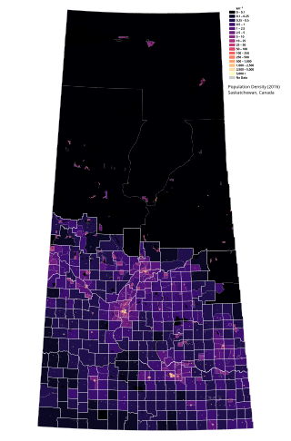
Saskatchewan is the middle province of Canada's three Prairie provinces. It has an area of 651,900 km2 (251,700 mi2) and a population of 1,132,505 (Saskatchewanians) as of 2021. Saskatchewan's population is made of 50.3% women and 49.7% men. Most of its population lives in the Southern half of the province.

<span class="mw-page-title-main">Maillardville</span> Neighbourhood of Coquitlam in Lower Mainland, British Columbia, Canada

Maillardville is a community on the south slope of the city of Coquitlam, British Columbia, Canada.

According to the 2021 census, the City of Edmonton had a population of 1,010,899 residents, compared to 4,262,635 for all of Alberta, Canada. The total population of the Edmonton census metropolitan area (CMA) was 1,418,118, making it the sixth-largest CMA in Canada.

<span class="mw-page-title-main">Saskatoon metropolitan area</span> Census Metropolitan Area in Saskatchewan, Canada

The Saskatoon region is the greater metropolitan area of Saskatoon, Saskatchewan. As of 2021 the Statistics Canada estimates the region's population to be 317,480 people.

<span class="mw-page-title-main">Demographics of Calgary</span>

In the 2021 Census, the City of Calgary had a population of 1,306,784 residents, representing 30.7% of the 4,262,635 residents in all of Alberta, and 3.5% compared to a population of 36,991,981 in all of Canada. The total population of the Calgary census metropolitan area (CMA) was 1,481,806. Calgary is the largest city in Alberta, and the third-largest municipality and fifth-largest metropolitan area in Canada, as of 2021.

The demographics of Winnipeg reveal the city to be a typically Canadian one: multicultural and multilingual. Winnipeg is also prominent in the size and ratio of its First Nations population, which plays an important part in the city's makeup. About 12.4% of Winnipeggers are of Indigenous descent, which vastly exceeds the national average of 5.0%.

<span class="mw-page-title-main">Burnaby North—Seymour</span> Federal electoral district in British Columbia, Canada

Burnaby North—Seymour is a federal electoral district in British Columbia. It encompasses a portion of British Columbia previously included in the electoral districts of Burnaby—Douglas and North Vancouver.

<span class="mw-page-title-main">Burnaby South</span> Federal electoral district in British Columbia, Canada

Burnaby South is a federal electoral district in British Columbia. It encompasses a portion of British Columbia previously included in the electoral districts of Burnaby—Douglas and Burnaby—New Westminster.

South Asian Canadians in Metro Vancouver are the third-largest pan-ethnic group in the region, comprising 369,295 persons or 14.2 percent of the total population as of 2021. Sizable communities exist within the city of Vancouver along with the adjoining city of Surrey, which houses one of the world's largest South Asian enclaves.

References

  1. 1 2 Government of Canada, Statistics Canada (September 2, 2022). "Census Profile, 2021 Census of Population Profile table 9330233.00 British Columbia [Census tract]". www12.statcan.gc.ca.
  2. 1 2 Government of Canada, Statistics Canada (September 2, 2022). "Census Profile, 2021 Census of Population Profile table 9330223.01 British Columbia [Census tract]". www12.statcan.gc.ca.
  3. 1 2 Government of Canada, Statistics Canada (September 2, 2022). "Census Profile, 2021 Census of Population Profile table 9330223.02 British Columbia [Census tract]". www12.statcan.gc.ca.
  4. "Town Centres". City of Burnaby . Retrieved May 24, 2024.
  5. "Biography – EDMONDS, HENRY VALENTINE – Volume XII (1891-1900)". Dictionary of Canadian Biography . Retrieved May 24, 2024.
  6. Vanderdeen, Lauren (March 14, 2024). "Burnaby's long-awaited arena to finally open next month". Burnaby Now. Retrieved May 24, 2024.
  7. "Does Burnaby have the world's most super-diverse neighbourhood? (Part 2)". Vancouver Sun.
  8. Government of Canada, Statistics Canada (February 8, 2017). "Census Profile, 2016 Census – 9330233.00 [Census tract], British Columbia and Vancouver [Census metropolitan area], British Columbia". www12.statcan.gc.ca.
  9. Government of Canada, Statistics Canada (February 8, 2017). "Census Profile, 2016 Census – 9330223.01 [Census tract], British Columbia and Vancouver [Census metropolitan area], British Columbia". www12.statcan.gc.ca.
  10. Government of Canada, Statistics Canada (February 8, 2017). "Census Profile, 2016 Census – 9330223.02 [Census tract], British Columbia and Vancouver [Census metropolitan area], British Columbia". www12.statcan.gc.ca.
  11. Government of Canada, Statistics Canada (November 27, 2015). "NHS Profile, 9330233.00, British Columbia, 2011". www12.statcan.gc.ca.
  12. Government of Canada, Statistics Canada (November 27, 2015). "NHS Profile, 9330223.01, British Columbia, 2011". www12.statcan.gc.ca.
  13. Government of Canada, Statistics Canada (November 27, 2015). "NHS Profile, 9330223.02, British Columbia, 2011". www12.statcan.gc.ca.
  14. Government of Canada, Statistics Canada (July 23, 2020). "2006 Census Tract profiles Census tract profile for 0233.00 (CT), Vancouver (CMA) and British Columbia". www12.statcan.gc.ca.
  15. Government of Canada, Statistics Canada (July 23, 2020). "2006 Census Tract profiles Census tract profile for 0223.01 (CT), Vancouver (CMA) and British Columbia". www12.statcan.gc.ca.
  16. Government of Canada, Statistics Canada (July 23, 2020). "2006 Census Tract profiles Census tract profile for 0223.02 (CT), Vancouver (CMA) and British Columbia". www12.statcan.gc.ca.
  17. Government of Canada, Statistics Canada (December 23, 2013). "2001 Census Area Profiles Profile of Citizenship, Immigration, Birthplace, Generation Status, Ethnic Origin, Visible Minorities and Aboriginal Peoples, for Census Metropolitan Areas, Tracted Census Agglomerations and Census Tracts, 2001 Census". www12.statcan.gc.ca. Retrieved April 13, 2024.
  18. Government of Canada, Statistics Canada (December 23, 2013). "Population and Dwelling Counts for Census Metropolitan Areas, Census Agglomerations and Census Tracts, 2001 and 1996 Censuses - 100% Data". www12.statcan.gc.ca. Retrieved April 13, 2024.