Burnaby is a city in British Columbia, Canada, part of Metro Vancouver and immediately to the east of the City of Vancouver. It is the third-largest city in British Columbia by population, following Vancouver and nearby Surrey. Burnaby was incorporated in 1892 and achieved its City status in 1992, 100 years after incorporation. It is the seat of Metro Vancouver's regional government.

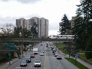
Metrotown is an elevated station on the Expo Line of Metro Vancouver's SkyTrain rapid transit system, and is located along Central Boulevard, directly across from the Metropolis at Metrotown shopping centre, in Burnaby, British Columbia, Canada. As of 2019, it is the second-busiest station in the SkyTrain system.

Metropolis at Metrotown is a three-storey shopping mall complex in Metrotown, Burnaby, British Columbia, Canada. It is the largest mall in British Columbia, and the third-largest in Canada behind Alberta's West Edmonton Mall and Ontario's Square One Shopping Centre, with 27 million customer visits annually. The mall is located adjacent to Metrotown station on the SkyTrain rapid transit system. Three office buildings are part of the complex along Central Boulevard.
Kingsway is a major thoroughfare that crosses through the Canadian cities of Vancouver and Burnaby, British Columbia. The road runs diagonally from northwest to southeast, emerging from Vancouver's Main Street just south of East 7th Avenue and becoming 12th Street at the Burnaby–New Westminster border.

East Vancouver is a region within the city of Vancouver, British Columbia, Canada. Geographically, East Vancouver is bordered to the north by Burrard Inlet, to the south by the Fraser River, and to the east by the city of Burnaby. East Vancouver is divided from Vancouver's "West Side" by Ontario St.

Renfrew–Collingwood is a large neighbourhood that lies on the eastern side of Vancouver, British Columbia, Canada, on its boundary with Burnaby and encompassing an area that was one of the earlier developed regions of the city. It is a diverse area that includes a substantial business community in several areas, as well as some of the fastest-growing residential sectors of Vancouver. In 2011, the neighbourhood had a population of 50,500, 38.4% of whom claim Chinese as their first language.

The Crystal Mall is an ethnic shopping mall oriented towards the local Chinese community in Burnaby, British Columbia, Canada. It is located at 4500 Kingsway at the intersection with Willingdon Avenue in Metrotown, directly adjoined to the Hilton Metrotown Vancouver Hotel. A 26 floor residential tower called Residence at the Crystal was also constructed that connects to the rest of the shopping complex.
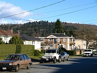
North Burnaby is a general name for a large neighbourhood in the City of Burnaby, British Columbia, that includes a number of smaller ones. It stretches from Boundary Road in the west to Burnaby Mountain with Simon Fraser University in the east and bounded by Burrard Inlet to the north and the Lougheed Highway to the south. It is a desirable place to live for many local and immigrant families which is reflected by real-estate prices that keep climbing and have doubled in the last 15 years.

Brentwood Park, or simply Brentwood, is a neighbourhood in North Burnaby, British Columbia, between Willingdon Avenue to the west and Springer Avenue to the east. Hastings Street separates it from the Capitol Hill area to the north, while Lougheed Highway marks the dividing line between this residential area and an area of commercial and industrial land to the south.
Parkcrest is a hillside neighbourhood in North Burnaby adjacent to Kensington Park which gave it its name. It has a long rectangular shape stretched north to south and is bounded by Springer Avenue to the west and Kensington Avenue to the east. To the north its border runs along Hastings Street, its southern border lies along the Lougheed Highway and Skytrain tracks. Its elevation gradually lowers to the south and ends up in Central Valley, quite low above the level of Burnaby Lake.
Lochdale is a single-family neighbourhood in the north-eastern part of Burnaby, near Burnaby Mountain. It lies between Kensington Ave to the west and Duthie Ave to the east. Hastings Street marks its northern limits while Halifax Street closes the rectangle in the south. Additionally, a large hillside residential area between Burnaby Mountain Parkway and Greystone Drive also belongs to Lochdale. Several major thoroughfares connecting north and south run through this neighbourhood - the earlier mentioned Kensington Avenue, Duthie Avenue, and Sperling Avenue.
Montecito, for administrative and planning purposes also known as "Sperling-Broadway", is a neighbourhood in Burnaby, British Columbia, Canada.

Willingdon Heights is a neighbourhood in Burnaby, British Columbia, Canada. It is named after a major Burnaby thoroughfare Willingdon Avenue connecting North Burnaby with Kingsway and the Metrotown area in the south.
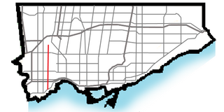
Royal York Road, historically known as Church Street or New Church Street, is a north-south arterial road in Toronto, Ontario, Canada. It is a concession road, 5 concessions (10 km) west of Yonge Street, and runs through many residential neighbourhoods, most notably Mimico and the Kingsway. It is classified as a "minor arterial" road by the city of Toronto.
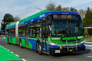
The R4 41st Ave is an express bus route with bus rapid transit elements in Metro Vancouver, British Columbia, Canada. Part of TransLink's RapidBus network, it replaced the 43 Express that travelled along 41st Avenue, a major east–west route that connects the University of British Columbia (UBC) to the SkyTrain system's Oakridge–41st Avenue station on the Canada Line and Joyce–Collingwood station on the Expo Line.
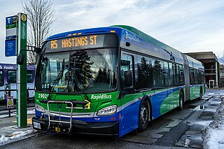
The R5 Hastings St is an express bus service with bus rapid transit elements in Metro Vancouver, Canada. Part of TransLink's RapidBus network, it travels along Hastings Street, a major east–west route, and connects Simon Fraser University to the SkyTrain system's Burrard station on the Expo Line in Downtown Vancouver. It replaced the 95 B-Line route on January 6, 2020.

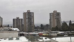
Metrotown is a town centre serving the southwest quadrant of Burnaby, British Columbia, Canada. It is one of the city's four officially designated town centres, as well as one of Metro Vancouver's regional town centres. It is the downtown of the City of Burnaby.
Maywood is a mainly-rental low-income residential neighborhood in Burnaby, and is a part of the larger Metrotown area. The neighborhood consists of low-rise apartments built during the population boom in the Metrotown area in the 1970s, and 1980s, although the neighborhood is quickly changing. Geographically, the Maywood neighbourhood's boundaries are Grange Street and Kingsway to the north, Nelson Avenue and Bennett and Bonsor Streets to the east, Imperial Street to the south and Boundary Road to the west, and it includes Central Park.

South Slope, sometimes referred to as Southern Burnaby, is a mainly single-family neighborhood in Burnaby in British Columbia, Canada, just southeast of Metrotown. It borders Suncrest, an all single-family home neighbourhood to the west, and goes as far east as Edmonds. Although the northern boundary of South Slope is Rumble Street, many residents north of the street consider themselves living in South Slope, including South Slope Elementary, and Burnaby South Secondary School. The neighbourhood gets its name from the steep slope it is located on. The neighbourhood is one of the oldest parts of the city, which can be seen be seen in Nelson Elementary, which is over a hundred years old, and dozens of Heritage Homes.