Fredericksburg, Indiana

Last updated
Fredericksburg, Indiana
Fredericksburg, Indiana.jpg
Washington County Indiana Incorporated and Unincorporated areas Fredericksburg Highlighted 1825720.svg
Location of Fredericksburg in Washington County, Indiana.
Coordinates: 38°25′57″N86°11′24″W / 38.43250°N 86.19000°W / 38.43250; -86.19000
Country United States
State Indiana
County Washington
Township Posey
Area
[1]
  Total1.09 sq mi (2.83 km2)
  Land1.07 sq mi (2.78 km2)
  Water0.02 sq mi (0.05 km2)
Elevation
[2]
614 ft (187 m)
Population
 (2020)
  Total129
  Density120.00/sq mi (46.32/km2)
Time zone UTC-5 (Eastern (EST))
  Summer (DST) UTC-5 (EST)
ZIP code
47120
Area code(s) 812, 930
FIPS code 18-25720 [3]
GNIS feature ID434794 [2]

Fredericksburg is an unincorporated community in Posey Township, Washington County, in the U.S. state of Indiana. [4] The population was 85 at the 2010 census, at the time it was a town.

Contents

History

Fredericksburg was laid out in 1815. [5] It was named for Frederick Royse, the original owner of the town site. [6] Fredericksburg was incorporated as a town in 1859. [7] The town disincorporated in June 2012. [8]

The Fredericksburg post office has been in operation since 1819. [9]

Geography

Fredericksburg is located at 38°25′57″N86°11′24″W / 38.43250°N 86.19000°W / 38.43250; -86.19000 (38.432609, -86.190128). [10] It is located on the Blue River, just downriver from the confluence of its North and South Forks. The river was a valuable resource in the town's beginning as the construction of a water mill brought growth and prosperity to the town. As electricity nullified the need to be located near water, the river became a liability. The town, located on a floodplain, is prone to flooding. The frequent flooding pushed the town into decline, encouraging many residents and businesses to flee the town or move to higher land.

According to the 2010 census, Fredericksburg has a total area of 1.01 square miles (2.62 km2), of which 0.99 square miles (2.56 km2) (or 98.02%) is land and 0.02 square miles (0.05 km2) (or 1.98%) is water. [11]

Demographics

Historical population
CensusPop.Note
2010 85
2020 12951.8%
U.S. Decennial Census [12]

2010 census

As of the census [13] of 2010, there were 85 people, 35 households, and 22 families living in the town. The population density was 85.9 inhabitants per square mile (33.2/km2). There were 41 housing units at an average density of 41.4 per square mile (16.0/km2). The racial makeup of the town was 92.9% White, 2.4% Native American, and 4.7% from two or more races. Hispanic or Latino of any race were 5.9% of the population.

There were 35 households, of which 34.3% had children under the age of 18 living with them, 40.0% were married couples living together, 17.1% had a female householder with no husband present, 5.7% had a male householder with no wife present, and 37.1% were non-families. 37.1% of all households were made up of individuals, and 20% had someone living alone who was 65 years of age or older. The average household size was 2.43 and the average family size was 3.18.

The median age in the town was 33.3 years. 29.4% of residents were under the age of 18; 8.3% were between the ages of 18 and 24; 28.2% were from 25 to 44; 17.7% were from 45 to 64; and 16.5% were 65 years of age or older. The gender makeup of the town was 55.3% male and 44.7% female.

2000 census

As of the census [3] of 2000, there were 92 people, 41 households, and 25 families living in the town. The population density was 91.7 inhabitants per square mile (35.4/km2). There were 44 housing units at an average density of 43.9 per square mile (16.9/km2). The racial makeup of the town was 100.00% White. Hispanic or Latino of any race were 1.09% of the population.

There were 41 households, out of which 29.3% had children under the age of 18 living with them, 43.9% were married couples living together, 12.2% had a female householder with no husband present, and 36.6% were non-families. 31.7% of all households were made up of individuals, and 9.8% had someone living alone who was 65 years of age or older. The average household size was 2.24 and the average family size was 2.77.

In the town, the population was spread out, with 21.7% under the age of 18, 8.7% from 18 to 24, 34.8% from 25 to 44, 17.4% from 45 to 64, and 17.4% who were 65 years of age or older. The median age was 39 years. For every 100 females, there were 109.1 males. For every 100 females age 18 and over, there were 100.0 males.

The median income for a household in the town was $21,250, and the median income for a family was $31,563. Males had a median income of $25,000 versus $35,250 for females. The per capita income for the town was $10,626. There were 21.4% of families and 23.5% of the population living below the poverty line, including 19.0% of under eighteens and 23.1% of those over 64.

Notable people

Related Research Articles

<span class="mw-page-title-main">Milltown, Indiana</span> Town in Indiana, United States

Milltown is a town in Whiskey Run Township in Crawford County, Indiana and in Blue River and Spencer townships in Harrison County. The population was 818 at the time of the 2010 census.

<span class="mw-page-title-main">Pierceton, Indiana</span> Town in Indiana, United States

Pierceton is a town in Washington Township, Kosciusko County, in the U.S. state of Indiana. The population was 928 at the 2020 census.

<span class="mw-page-title-main">Kingsbury, Indiana</span> Town in Indiana, United States

Kingsbury is a town in Washington Township, LaPorte County, Indiana, just northwest of the intersection of U.S. Route 35 and U.S. Route 6. The town was founded in 1835 and incorporated on March 3, 1941. During 1940 - 1941, the Kingsbury Ordnance Plant (KOP) was built for use during World War II. The plant closed after the war but reopened during the Korean War, closing permanently in 1959. The population was 242 at the 2010 census. It is included in the Michigan City, Indiana-La Porte, Indiana Metropolitan Statistical Area. The town has its own fire department, KVFD, and a Greek revival style First Baptist church built in 1851 with its own graveyard and Winchell Cemetery.

<span class="mw-page-title-main">Morgantown, Indiana</span> Town in Indiana, United States

Morgantown is a town at the intersection of Indiana state routes 135 and 252 in Jackson Township, Morgan County, in the U.S. state of Indiana. The population was 1,014 at the 2020 census.

<span class="mw-page-title-main">Marshall, Indiana</span> Town in Indiana, United States

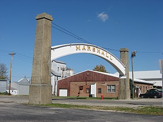
Marshall is a town in Washington Township, Parke County, Indiana, United States. As of the 2010 census, the population was 324.

<span class="mw-page-title-main">Lynn, Indiana</span> Town in Indiana, United States

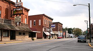
Lynn is a town in Washington Township, Randolph County, in the U.S. state of Indiana. The population was 1,097 at the 2010 census.

<span class="mw-page-title-main">Campbellsburg, Indiana</span> Town in Indiana, United States

Campbellsburg is a town in Brown Township, Washington County, in the U.S. state of Indiana. The population was 585 at the 2010 census.

<span class="mw-page-title-main">Hardinsburg, Indiana</span> Town in Indiana, United States

Hardinsburg is a town in Posey Township, Washington County, in the U.S. state of Indiana. The population was 222 at the 2020 census.

<span class="mw-page-title-main">Little York, Indiana</span> Town in Indiana, United States

Little York is a town in Gibson Township, Washington County, in the U.S. state of Indiana. The population was 192 at the 2010 census.

<span class="mw-page-title-main">Livonia, Indiana</span> Town in Indiana, United States

Livonia is a town in Madison Township, Washington County, in the U.S. state of Indiana. The population was 128 at the 2010 census.

<span class="mw-page-title-main">Saltillo, Indiana</span> Town in Indiana, United States

Saltillo is a town in Brown Township, Washington County, in the U.S. state of Indiana. The population was 92 at the 2010 census.

<span class="mw-page-title-main">Rockwell, Iowa</span> City in Iowa, United States

Rockwell is a city in Cerro Gordo County, Iowa, United States. The population was 1,071 at the time of the 2020 census. It is part of the Mason City Micropolitan Statistical Area.

<span class="mw-page-title-main">Fredericksburg, Iowa</span> City in Iowa, United States

Fredericksburg is a city in Chickasaw County, Iowa, United States. The population was 987 at the time of the 2020 census.

<span class="mw-page-title-main">Castanea, Pennsylvania</span> Census-designated place in Pennsylvania, United States

Castanea is a census-designated place (CDP) in Castanea Township, Clinton County, Pennsylvania, United States. The population was 1,125 at the 2010 census.

<span class="mw-page-title-main">Fredericksburg, Lebanon County, Pennsylvania</span> Census-designated place in Pennsylvania, United States

Fredericksburg is an unincorporated community and census-designated place (CDP) in Bethel Township, Lebanon County, Pennsylvania, United States. The population was 1,784 at the 2020 census, up from 1,357 at the 2010 census and 987 at the 2000 census.

<span class="mw-page-title-main">Hurricane, West Virginia</span> City in West Virginia, United States

Hurricane is a city in Putnam County, West Virginia, United States. The population was 6,977 at the 2020 census. Located roughly equidistant from Charleston and Huntington, it is part of the Huntington–Ashland metropolitan area.

<span class="mw-page-title-main">Irving, Wisconsin</span> Town in Wisconsin, United States

Irving is a town in Jackson County, Wisconsin, United States. The population was 602 at the 2000 census.

<span class="mw-page-title-main">North Crows Nest, Indiana</span> Town in Indiana, United States

North Crows Nest is a town in Washington Township, Marion County, Indiana, United States. It is approximately 7 miles (11 km) north of downtown Indianapolis. The population was 44 at the 2020 census. It has existed as an "included town" since 1970, when it was incorporated into Indianapolis as part of Unigov. It is part of Indianapolis, but retains town governmental powers under IC 36-3-1-11.

<span class="mw-page-title-main">Williams Creek, Indiana</span> Town in Indiana, United States

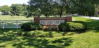
Williams Creek is a town in Washington Township, Marion County, Indiana, United States. It is located about 9 miles (14 km) north of downtown Indianapolis. The population was 430 at the 2020 census. It has existed as an "included town" since 1970, when it was incorporated into Indianapolis as part of Unigov. It is part of Indianapolis, but retains a functioning town government under IC 36-3-1-11.

<span class="mw-page-title-main">Wynnedale, Indiana</span> Town in Indiana, United States

Wynnedale is a town in Washington Township, Marion County, Indiana, United States. The population was 215 at the 2020 census. It has existed as an "included town" since 1970, when it was incorporated into Indianapolis as part of Unigov. It is part of Indianapolis, but retains a functioning town government under IC 36-3-1-11.

References

  1. "2020 U.S. Gazetteer Files". United States Census Bureau. Retrieved March 16, 2022.
  2. 1 2 U.S. Geological Survey Geographic Names Information System: Fredericksburg, Indiana
  3. 1 2 "U.S. Census website". United States Census Bureau . Retrieved 2008-01-31.
  4. "Fredericksburg, Indiana". Geographic Names Information System . United States Geological Survey, United States Department of the Interior . Retrieved 2016-07-07.
  5. History of Lawrence, Orange, and Washington Counties, Indiana: From the Earliest Time to the Present. Higginson Book Company. 1884. pp.  786.
  6. Stevens, Warder William; Davis, Lulie (1916). Centennial History of Washington County, Indiana: Its People, Industries and Institutions. McDowell Publications. p. 596.
  7. Biographical and Historical Souvenir for the Counties of Clark, Crawford, Harrison, Floyd, Jefferson, Jennings, Scott, and Washington, Indiana. Chicago Printing Company. 1889. pp.  262.
  8. "Washington County Communities". Archived from the original on 2015-11-08. Retrieved 2015-09-10.
  9. "Washington County". Jim Forte Postal History. Archived from the original on August 7, 2016. Retrieved July 7, 2016.
  10. "US Gazetteer files: 2010, 2000, and 1990". United States Census Bureau. 2011-02-12. Retrieved 2011-04-23.
  11. "G001 - Geographic Identifiers - 2010 Census Summary File 1". United States Census Bureau. Archived from the original on 2020-02-13. Retrieved 2015-07-16.
  12. "Census of Population and Housing". Census.gov. Retrieved June 4, 2016.
  13. "U.S. Census website". United States Census Bureau . Retrieved 2012-12-11.