
Braselton is a town in Barrow, Gwinnett, Hall, and Jackson counties in the U.S. state of Georgia, approximately 43 miles (69 km) northeast of Atlanta. As of the 2010 census, the town had a population of 7,511, and in 2018 the estimated population was 11,652.

Warner Robins is a city in Houston and Peach counties in the U.S. state of Georgia. It is currently the state's eleventh-largest incorporated city, with a population of 80,308 in the 2020 census.
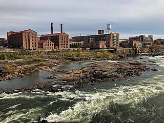
Columbus is a consolidated city-county located on the west-central border of the U.S. state of Georgia. Columbus lies on the Chattahoochee River directly across from Phenix City, Alabama. It is the county seat of Muscogee County, with which it officially merged in 1970; the original merger excluded Bibb City, which joined in 2000 after dissolving its own city charter.

Cedartown is a city and the county seat of Polk County, Georgia, United States. As of the 2020 census, the city had a population of 10,190. Cedartown is the principal city of the Cedartown micropolitan area, which is included in the Atlanta–Athens-Clarke–Sandy Springs combined statistical area.

Blairsville is a city and the county seat of Union County, on the northern border of Georgia, United States. It was founded near the Nottely River, which was dammed in 1942 as part of the Tennessee Valley Authority project, forming Lake Nottely. As of the 2020 census, the city had a population of 616.

The city of Sandersville is the county seat of Washington County, Georgia, United States. The population was 5,813 in 2020. It is also a part of the Central Savannah River Area. Sandersville is known as the "Kaolin Capital of the World" due to its abundance of kaolin.

Helen is a small city in White County, Georgia, United States, located along the Chattahoochee River. The population was 531 at the 2020 census. The city has now been made over, as a tourist attraction, to look like an old-world Bavarian village. This idea was suggested by John Kollock, an Atlanta artist.

George Town is the capital and largest city in the Cayman Islands, located on Grand Cayman. As of 2022, the city had a population of 40,957, making it the largest city of all the British Overseas Territories.

The Tioughnioga River is a 34.2-mile-long (55.0 km) tributary of the Chenango River in central New York in the United States. It drains a dissected plateau area east of the Finger Lakes at the northernmost edge of the watershed of the Susquehanna River.
South Korea is made up of 22 first-tier administrative divisions: 6 metropolitan cities, 1 special city, 1 special self-governing city, and 14 provinces, including three special self-governing provinces and five claimed by the ROK government. These are further subdivided into a variety of smaller entities, including cities, counties, districts, towns, townships, neighborhoods and villages.

Nanae is a town located in Oshima Subprefecture, Hokkaido, Japan. In April 2017, the town had an estimated population of 28,514, with 13,639 households, and a population density of 130/km2 (340/sq mi). The total area is 216.61 km2 (83.63 sq mi).

Shikabe is a town located in Oshima Subprefecture, Hokkaido, Japan.
An incorporated town is a town that is a municipal corporation.

Phalaborwa is a town in the Mopani District Municipality, Limpopo province, South Africa.

Tzaneen is a large tropical garden town situated in the Mopani District Municipality of the Limpopo province in South Africa. It is situated in a high rainfall fertile region with tropical and subtropical agriculture taking place in a 20,000 square kilometres (7,700 sq mi) region. It is Limpopo's second largest town after Polokwane.

The Greater Accra Region has the smallest area of Ghana's 16 administrative regions, occupying a total land surface of 3,245 square kilometres. This is 1.4 per cent of the total land area of Ghana. It is the most populated region, with a population of 5,455,692 in 2021, accounting for 17.7 per cent of Ghana's total population.
Ga-Rankuwa is a large settlement located about 37 km north-west of Pretoria. Provincially it is in Gauteng province, but it used to fall in Bophuthatswana during the apartheid years, and under the North West province until the early 2000s.
Mabopane is a residential township in South Africa. It is situated in the Tshwane Metropolitan Municipality, to the north of Pretoria in Gauteng.

Hkamti Township or Khamti Township is a township in Hkamti District in the Sagaing Region of Burma (Myanmar). The principal town is Hkamti. As of 2014 the township had a population of 47,658 people and covered an area of 8,174 square kilometres (3,156 sq mi). The township is dominated by the Chindwin River and its tributaries as well as thickly forested areas. Nearly half the active working population are employed in agriculture, forestry or fishing. The township is a producer of rice and has gold and jade reserves.

Nima is a Zongo residential town in the Greater Accra Region of Ghana. The town is popular because of its market – the Nima market. The name Nima has its etymology from the Ga Language which literally means the "city of the King". Nii means King in the Ga language, while the word city in the same language is mann. There have been a few contrasting views about the name, however, with some pointing to the town's Muslim community to say Nima was a reference to the Arabic word, "Ni'ma", which means blessings.


