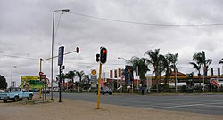
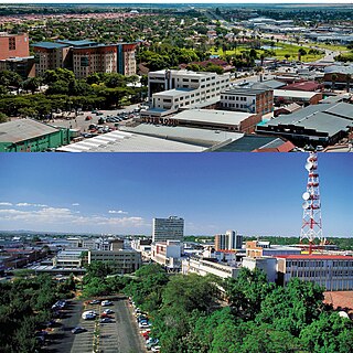
Giyani is a town situated in the north-eastern part of Limpopo Province,[2]South Africa. It is the administrative capital of the Mopani District Municipality and a former capital of the defunct GazankuluBantustan. The town of Giyani has seven sections: Section A, Section D1, Section D2, Section E, Section F, Kremetart, and Giyani CBD. Risinga View and Church View are new residential areas in Giyani, but they fall under the local traditional leaders. The Giyani CBD is nicknamed Benstore, and this name is commonly used by residents of the region. Giyani is surrounded by a number of villages with rich Tsonga cultural activities, administered by the Greater Giyani Local Municipality.
In 1969, the Gazankulu government named a new ward at Elim Hospital 'Giyani Ward' in honor of the Gazankulu capital. The Current Mayor of Greater Giyani municipality is Thandi Zitha of ANC.[3]
Giyani was established during the 1960s as the capital city of Gazankulu, on land belonging to the Homu Royal Family.[4] The Risinga Community (under headman Chabalala) originally came from the Elim district, next to the township of Waterval.
The Old Parliament Buildings in Giyani, the ministerial houses, and the Palace of the Chief Minister of Gazankulu were built on what used to be the Chief's Kraal and headquarters of the Risinga Community. Across the main road, the Risinga Community used to drive their herds of cattle for grazing at a place known today as Giyani Golf Course. Giyani Section E, Section A, Sections D1 and D2, and the CBD of Giyani, known as Bendstore, were villages of the Risinga Community. The Risinga Community was forcefully removed from their land during the 1960s[5] in order to make way for the new capital of Gazankulu, and they were relocated to the foothills of Man'ombe Mountain in Homu Block 14 and Makoxa Village with their chief, Hosi Homu Chabalala.[5]
Land claims
The Risinga Community, under Hosi Homu Chabalala, successfully claimed back their land, which includes Giyani Section E, Section A, Sections D1 and D2, and some parts of Section F. The whole of Man'ombe Mountain Nature Reserve and the entire Giyani CBD were given back to Hosi Homu Chabalala under the settlements scheme with the government. While the other Chabalala headman, Hosi Siyandhanim, successfully claimed some parts of Giyani Section E and Section F and the western portion of Giyani CBD, Mapuve, Jim Nghalalume, and Siyandhani as host villages,
Hosi Maswanganyi (Mavhusa) also successfully claimed back their land, which includes: Gandlanani, Basani, N'wamankena, Dingamadzi, Sikhunyani, Kremetart, Dzingidzingi A, B, and C, Bode A and B, Mencisi, and Maswanganyi Village. Hosi Khakhala also successfully claimed back their land, which includes: Muyexe Block 01, Mninginisi Block 02, Mninginisi Block 03, N'wadzekudzeku Block 04, Shivulani Block 05A, Mbatlo Block 05B, Mavalani Block 06, Thomo Block 07, Khakhala Block 08A, Mhlava Block 08B, and Gawula Block 09 Village.
Culture
Most residents of Giyani speak Xitsonga[6] as their first language. The Tsonga women perform the xibelani dance[7]'and called the dance Xigaza, while the men enjoy mpuluto and makhwaya. The Tsonga people also engage in a custom dance called mchongolo. Xibelani is an African skirt designed to make the wearer's hips look bigger so that the hip movement during the xibelani dance can be more apparent. The Tsonga people have their own distinct music when the xibelani dance is performed.
The staple diet in Giyani is maize porridge (vuswa or pap in Afrikaans) and rice, often eaten with meat, chicken, and vegetables (matsavu).
"Giyani" is one of the tracks on the album "Third World Child" by Johnny Clegg and his band Savuka, written about leaving the stress of Johannesburg to get some peace and quiet in Giyani.[8]
Climate
Giyani is situated within the sub-tropical zone.[9] It can be very hot in the summer, reaching a maximum temperature of 41°C in the summer and 25°C during the winter. Winters are mild during the day and cold during the night.
The rainy season is between September and March, while the winter season is from April to August.[10]
Economy
Giyani's economy is predominately rural-based. Cattle ranching and the production of maize, peanuts, tomatoes, potatoes, mangoes, and bananas form the backbone of farming.[11] With the economic boom, Giyani has now become a major retail and entertainment center for the local population. Modern shopping centers, with all the well-known chain stores presented, have vastly uplifted the local trade.[12]
Residential areas
Residential areas in the area surrounding Giyani CBD include Giyani Sections A, E, and F, D1, D2, and Kremetart [1].
Two more residential areas, Risinga View and Church View, aka Homu Block 15, have recently been established. These two fall under local traditional leaders.
Other communities under Traditional Leaders (Tihosi) include Siyandhani, Dzingi-dzingi, Ka-Ndhambi, Mageva, Bambeni, Daniel (Makhwivirini), Maphata, Munghonghoma, Ngove, Khaxani, Mphagani, Xitlakati, Mayephu, N'wa-Marhanga, Xamfana, Nkomo A, Kheyi, Loloka, Maswanganyi, Mbhedle, Mushiane, Mayephu, Dzumeri Township, Hluvukani, Khaxani(Mhintlwa), Makhuva, Xawela Bloc 23, Xikhumba, Mbawula, Phalaubeni, Hlomela, Ndindani, Vuhehli, Nkomo B, Nkomo C, N'wa-Khuwani, Bambeni, Mzilela, Matsotsosela, Dzumeri RDP, Homu, Sikhunyani, Mninginisi, Xikukwani,Mavalani, Nkurhi, Tomu, Basani.
Education
Some of the independent schools in Giyani include Khanyisa Education Centre,[13] Risinga Secondary School, Nkwangulatilo Education Centre,[14] Nyukani Education Centre, High Quality Education Centres, Giyani College of Technology and Management, and Muhluri Combine School. Public schools include Kheto Nxumayo Agricultural High School and Giyani High School.
The R81 is the major road that runs through Giyani. It links Giyani to Polokwane and Malamulele and joins the R524 to Punda Maria entrance gate of the Kruger National Park. The R81[16] joins the N1 to Pretoria and Johannesburg in Polokwane, next to the Mall of the North.
Giyani's location in the warm African bushveld makes it attractive for both local and international visitors. The Giyani Golf Course is home to zebras, giraffes, bushbucks, and some other herbivores; however, the viewing of these animals has not yet been commercialized.
At the moment, there are a number of bed and breakfast and guest house facilities for tourists. A few are: Hanyani Lodge, Riverside Guest House, Xisaka Bed and Breakfast, Tihosi Guest House, Elridge Mountain Lodge, Rosanna Guest House, Nwayitelo Lodge, and Mopani Guest House.
Limpopo Lodge (formerly Giyani Hotel) is situated in the center of town and managed by the Oasis Group. Man'ombe Nature Reserve is located 6km east of Giyani.
Giyani also borders Kruger National Park on the western side of the Northern Region. Historically, Giyani had no entry point to Kruger National Park, even though Giyani shares a long border with Kruger National Park. There was a plan to open a new gate, known as Shangoni Gate, at Muyexe Village, 30km north-east of Giyani town. This gate was supposed to bring much-needed development to the nearby villages of Muyexe, Mahonisi, and Mtititi, where unemployment is 80%.[21] These villages have been historically poor, despite the fact that they border one of the world's best safari destinations.
Related Research Articles
Polokwane, formerly and sometimes also known as Pietersburg, is the capital city of the Limpopo Province in South Africa. It is the country's largest urban centre north of Gauteng. It was one of the nine host cities of the 2010 FIFA World Cup.
Limpopo is the northernmost province of South Africa. It is named after the Limpopo River, which forms the province's western and northern borders. The capital and largest city in the province is Polokwane, while the provincial legislature is situated in Lebowakgomo.
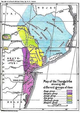
The Tsonga people are a Bantu ethnic group primarily native to Southern Mozambique and South Africa. They speak Xitsonga, a Southern Bantu language. A very small number of Tsonga people are also found in Zimbabwe and Northern Eswatini. The Tsonga people of South Africa share some history with the Tsonga people of Southern Mozambique, and have similar cultural practices, but differ in the dialects spoken.
Tzaneen is a large tropical garden town situated in the Mopani District Municipality of the Limpopo province in South Africa. It is situated in a high rainfall fertile region with tropical and subtropical agriculture taking place in a 20,000 square kilometres (7,700 sq mi) region. It is Limpopo's second largest town after Polokwane.
Gazankulu was a bantustan in South Africa, intended by the apartheid government to be a semi-independent homeland for the Tsonga people. It was located in both the Northern Transvaal, now Limpopo province and Eastern Transvaal, now Mpumalanga province.
The Diocese of St Mark the Evangelist is a diocese in the Anglican Church of Southern Africa, in the geographical area of the Limpopo province in the north of South Africa.
Malamulele can refer to the town of Malamulele or the area of Malamulele. Both the town and area are in the Limpopo province of South Africa and predominantly occupied by Tsonga people. Malamulele town has one provincial road and one regional road; the R81 to Giyani and the R524 to Thohoyandou respectively. Malamulele is flanked by two rivers, Levubu River (Rivhubye) to the west and Letaba River to the east, meanwhile the Shingwedzi River runs from Malamulele West to Malamulele East, joining the Olifants in Mozambique on its way to the Indian Ocean. Malamulele is the seat of the Collins Chabane Local Municipality.
The Levubu River or Levuvhu is located in the northern Limpopo province of South Africa. Some of its tributaries, such as the Mutshindudi River and Mutale River rise in the Soutpansberg Mountains.
Bushbuckridge Municipality is a local municipality within the Ehlanzeni District Municipality, in the Mpumalanga province of South Africa. Commercial farming, which consists of pine and bluegum plantations, tobacco, cotton, sub-tropical fruits and vegetables is practised in the municipality's countryside. The municipality includes the southern part of the Kruger National Park. Bushbuckridge is the largest local municipality in Mpumalanga in terms of land size.
Green Farm is a village in the province of Limpopo in South Africa. The village is situated in the north east region of Limpopo province within the newly demarcated Collins Chabane Local Municipality. It used to be part of the Thulamela local municipality, Vhembe district. The village is located
Waterval is a residential township in front of Elim Hospital, it is situated in the Hlanganani district of the former Tsonga homeland of Gazankulu, alongside the R578 road to Giyani in the Limpopo province of South Africa. Waterval includes Njhakanjhaka, Lemana, Elim Hospital, Elim Mall, Hubyeni Shopping centre, Magangeni but excludes Shirley village, which is a separate and stand alone farm, sharing a legal boundary with Waterval and Mbhokota village to the east.
Namakgale is a large township lying 12 km outside Phalaborwa in Mopani District in the Limpopo province of South Africa. Its nearest neighbouring townships are Lulekani, Makhushane, Maseke and Mashishimale on the R71 road to Gravelotte (GaMaenetje). It is next to the Kruger National Park on the north eastern part of the Limpopo province previously Northern Transvaal. The township enjoys the annual Marula festival during the months of February and March, when the ripe Marula fruit harvest is at its peak, and the Marula traditional beer is brewed. This is home to the Amarula liqueur is harvested, and the pulp is shipped to Cape Town for further processing. The citizens of Namakgale will enjoy the Mopani worms first harvest during March and April, and the second harvest in December. the Mopani tree and the Morula tree are very important to the residents of the Namakgale as they bring important community subsistence farming.
Tiyani is a village situated on the banks of the Middle Letaba Dam in the Hlanganani District of the former Gazankulu homeland, which currently form part of the Vhembe District Municipality in the Limpopo province of South Africa.
The R578 is a Regional Route in South Africa that connects Louis Trichardt with Giyani via Waterval and Bungeni.
Xawela is a village in Greater Giyani Local Municipality in the Limpopo province of South Africa. The village was founded in the early 1965 by the homeland or bantustan system under the homeland of Gazankulu.
Ga-Sebotse, also known as Pinkie, is a large village in Ga-Matlala in the Blouberg Local Municipality of the Capricorn District Municipality of the Limpopo province of South Africa. It is located 73 km northwest of Polokwane and 37 km southwest of Senwabarwana.
Bennet Skheto Baloyi known by his stage name President Benny Mayengani is a South African Xitsonga singer. He rose to fame following the release of his debut studio album Tiba Ben in 2011.
Fumani N Shilubana, is a South African actor, director and producer. He is best known for his roles in the popular films Zama Zama, My Father's War and Kalushi: The Story of Solomon Mahlangu. His the founder of FatherFigureZA, a Foundation that seeks to integrate man back into the family unit and former Chairman of Midrand Heat Basketball Club. In 2022 May 6 with Yerhu Film Commission they launched Yerhu News a Xitsonga News bulletin that plays on YouTube every Friday at 19:00.
Chritian Nkakareng Rakgoale is a South African politician. As of June 2022, she has been the Member of the Executive Council (MEC) for Public Works, Roads and Infrastructure in the Limpopo provincial government. She previously served as the MEC for Social Development from May 2019 to June 2022. Rakgoale was elected to the Limpopo Provincial Legislature in May 2019. Before that, she served as the Executive Mayor of the Mopani District Municipality. Rakgoale is a member of the African National Congress.
Pule Josiah Shayi is a South African politician who has served as the mayor of Mopani District Municipality since 2019. Before that, he was Mayor of Ba-Phalaborwa Local Municipality from 2016 to 2019. He is best known as the Regional Chairperson of the African National Congress (ANC) in the Mopani region, an office he has held since 2017.
This page is based on this Wikipedia article Text is available under the CC BY-SA 4.0 license; additional terms may apply. Images, videos and audio are available under their respective licenses.