Garrett, Washington

Last updated

Garrett, Washington
CDP
Walla Walla County Washington Incorporated and Unincorporated areas Garrett Highlighted.svg
Location of Garrett, Washington
Coordinates: 46°3′46″N118°23′4″W / 46.06278°N 118.38444°W / 46.06278; -118.38444
CountryUnited States
State Washington
County Walla Walla
Area
  Total2.1 sq mi (5.5 km2)
  Land2.1 sq mi (5.5 km2)
  Water0.0 sq mi (0.0 km2)
Elevation
768 ft (234 m)
Population
 (2020) [1]
  Total1,771
  Density840/sq mi (320/km2)
Time zone UTC-8 (Pacific (PST))
  Summer (DST) UTC-7 (PDT)
FIPS code 53-26245 [2]
GNIS feature ID1512234 [3]

Garrett is a census-designated place (CDP) in Walla Walla County, Washington, United States. The population was 1,419 at the 2010 census.

Contents

Geography

Garrett is located at 46°3′46″N118°23′4″W / 46.06278°N 118.38444°W / 46.06278; -118.38444 (46.062643, -118.384364). [4] According to the United States Census Bureau, the CDP has a total area of 2.1 square miles (5.5 km2), all of it land.

Climate

According to the Köppen Climate Classification system, Apple Valley has a semi-arid climate, abbreviated "BSk" on climate maps. [5]

Demographics

Historical population
CensusPop.Note
2000 1,022
2010 1,41938.8%
2020 1,77124.8%

As of the census [2] of 2000, there were 1,022 people, 407 households, and 291 families residing in the CDP. The population density was 482.4 people per square mile (186.1/km2). There were 419 housing units at an average density of 197.8/sq mi (76.3/km2). The racial makeup of the CDP was 92.56% White, 0.20% Native American, 1.17% Asian, 4.50% from other races, and 1.57% from two or more races. Hispanic or Latino of any race were 5.38% of the population.

There were 407 households, out of which 31.2% had children under the age of 18 living with them, 62.9% were married couples living together, 6.1% had a female householder with no husband present, and 28.5% were non-families. 24.8% of all households were made up of individuals, and 12.0% had someone living alone who was 65 years of age or older. The average household size was 2.51 and the average family size was 2.98.

In the CDP, the age distribution of the population shows 25.0% under the age of 18, 4.9% from 18 to 24, 24.6% from 25 to 44, 26.8% from 45 to 64, and 18.8% who were 65 years of age or older. The median age was 43 years. For every 100 females, there were 95.8 males. For every 100 females age 18 and over, there were 93.2 males.

The median income for a household in the CDP was $38,750, and the median income for a family was $48,203. Males had a median income of $38,854 versus $24,643 for females. The per capita income for the CDP was $18,895. About 3.3% of families and 8.0% of the population were below the poverty line, including 10.1% of those under age 18 and 5.4% of those age 65 or over.

Related Research Articles

<span class="mw-page-title-main">Walla Walla County, Washington</span> County in Washington, United States

Walla Walla County is a county located in the U.S. state of Washington. As of the 2020 census, its population was 62,584. The county seat and largest city is Walla Walla. The county was formed on April 25, 1854 and is named after the Walla Walla tribe of Native Americans.

<span class="mw-page-title-main">South Whittier, California</span> Census designated place in California, United States

South Whittier is an unincorporated community and census-designated place in Los Angeles County, California just south of the city of Whittier. As of the 2020 census, the CDP had a total population of 56,415, down from 57,156 at the 2010 census.

<span class="mw-page-title-main">Springville, California</span> Census-designated place in California, United States

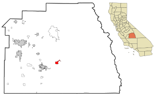
Springville is a census-designated place (CDP) in Tulare County, California, United States. The population was 967 at the 2020 census, up from 934 at the 2010 census.

<span class="mw-page-title-main">Matlacha Isles-Matlacha Shores, Florida</span> Census-designated place in Florida, United States

Matlacha Isles-Matlacha Shores is an unincorporated community and census-designated place (CDP) in Lee County, Florida, United States. The population was 227 at the 2020 census, down from 229 at the 2010 census. It is part of the Cape Coral-Fort Myers, Florida Metropolitan Statistical Area.

<span class="mw-page-title-main">East Missoula, Montana</span> CDP in Montana, United States

East Missoula is a census-designated place (CDP) in Missoula County, Montana, United States. It is part of the Missoula, Montana Metropolitan Statistical Area'. The population was 2,157 at the 2010 census, an increase from its population of 2,070 in 2000.

<span class="mw-page-title-main">Custer, Montana</span> Census-designated place in Montana, United States

Custer is a census-designated place (CDP) in Yellowstone County, Montana, United States. The population was 145 at the 2000 census.

<span class="mw-page-title-main">Sea Breeze, North Carolina</span> CDP in North Carolina, United States

Sea Breeze is a census-designated place (CDP) in New Hanover County, North Carolina, United States. The population was 1,969 at the 2010 census, up from 1,312 in 2000. It is part of the Wilmington Metropolitan Statistical Area.

<span class="mw-page-title-main">East Berwick, Pennsylvania</span> Census-designated place in Pennsylvania, United States

East Berwick is a census-designated place (CDP) in Salem Township, Luzerne County, Pennsylvania, United States. The population was 2,007 at the 2010 census.

<span class="mw-page-title-main">La Sal, Utah</span> CDP in Utah, United States

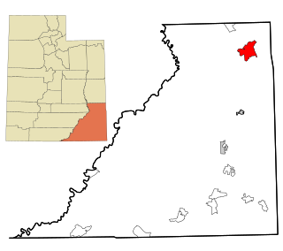
La Sal is a census-designated place (CDP) in northeastern San Juan County, Utah, United States. The population was 339 at the 2000 census. The name comes from the La Sal Mountains which means in Spanish "The Salt". The area is known for its uranium resources.

<span class="mw-page-title-main">Claypool Hill, Virginia</span> Census-designated place in Virginia, United States

Claypool Hill is a census-designated place (CDP) in Tazewell County, Virginia, United States. The population was 1,776 at the 2010 census, which was up from the 1,719 reported in 2000. Claypool is part of the Bluefield WV-VA micropolitan area which has a population of 107,578.

<span class="mw-page-title-main">Roosevelt, Washington</span> Census-designated place in Washington, United States

Roosevelt is an unincorporated community and census-designated place (CDP) in Klickitat County, Washington, United States. The population was 152 at the 2020 census. The Roosevelt Regional Landfill, one of the largest landfills in the United States, is located at Roosevelt.

<span class="mw-page-title-main">Greenwater, Washington</span> CDP in Washington, United States

Greenwater is a census-designated place (CDP) in the northwest United States in Pierce County, Washington. Southeast of Seattle, the population was 67 at the 2010 census, down from 91 in 2000. At the 2020 census, the population was 95.

<span class="mw-page-title-main">Burbank, Washington</span> CDP in Washington, United States

Burbank is a census-designated place (CDP) in Walla Walla County, Washington, United States, where the Snake River meets the Columbia. The population was 3,291 at the 2010 census. Named for Luther Burbank, the city is located just east of Pasco and Kennewick, across the Snake and Columbia Rivers, respectively. Burbank is part of the Tri-Cities, WA urban area, despite being located in the Walla Walla metropolitan area.

<span class="mw-page-title-main">College Place, Washington</span> City in Washington, United States

College Place is a city in Walla Walla County, Washington, United States. It neighbors the larger city of Walla Walla, and had a population of 9,902 at the 2020 census.

<span class="mw-page-title-main">Dixie, Washington</span> CDP in Washington, United States

Dixie is a census-designated place (CDP) in Walla Walla County, Washington, United States. The population was 197 at the 2010 census.

<span class="mw-page-title-main">Prescott, Washington</span> City in Washington, United States

Prescott is a city in central Walla Walla County, Washington. The population was 372 at the 2020 census.

<span class="mw-page-title-main">Touchet, Washington</span> CDP in Washington, United States

Touchet is a census-designated place (CDP) in Walla Walla County, Washington, United States. The population was 421 at the 2010 census.

<span class="mw-page-title-main">Walla Walla East, Washington</span> CDP in Washington, United States

Walla Walla East is a census-designated place (CDP) in Walla Walla County, Washington, United States. The population was 1,672 at the 2010 census.

<span class="mw-page-title-main">Wallula, Washington</span> CDP in Washington, United States

Wallula is a census-designated place (CDP) in Walla Walla County, Washington, United States. The population was 179 at the 2010 census.

Wonder Lake is a former census-designated place (CDP) in McHenry County, Illinois, United States. The population was 7,463 at the 2000 census. The CDP has been annexed by the village of Wonder Lake.

References

  1. "Census Bureau profile: Garrett, Washington". United States Census Bureau. May 2023. Retrieved May 10, 2024.
  2. 1 2 "U.S. Census website". United States Census Bureau . Retrieved January 31, 2008.
  3. "US Board on Geographic Names". United States Geological Survey. October 25, 2007. Retrieved January 31, 2008.
  4. "US Gazetteer files: 2010, 2000, and 1990". United States Census Bureau. February 12, 2011. Retrieved April 23, 2011.
  5. Climate Summary for Garrett, Washington