Geography of Abkhazia

Last updated

Map of Abkhazia Abkhazia detail map2.png
Map of Abkhazia

Abkhazia is a region in South Caucasus. It is a de facto independent republic, but internationally is mostly recognized as part of Georgia.

Contents

Geography

Abkhazia covers an area of about 8,660 square kilometres (3,340 sq mi) [1] at the western end of Georgia, on the north shore of the Black Sea. The Caucasus Mountains to the north and the northeast divide Abkhazia from Circassia. To the east, the region is bordered by Svaneti. To the southeast, Abkhazia is bounded by Samegrelo; and on the south and southwest by the Black Sea. The topography is varied as it ranges from the lowlands around the Black Sea to the high peaks in the north.

The region is extremely mountainous (nearly 75% is classified as mountains or foothills) and settlement is largely confined to the coast and a number of deep, well-watered valleys. [1] The Greater Caucasus Mountain Range runs along the region's northern border. The Gagra, Bzyb, and Kodori Ranges branch off from the Main Caucasus Range. The highest peaks of Abkhazia are in the northeast and east (along the border with Svaneti) and several exceed 4,000 meters (13,123 ft) above sea level. The highest mountain is Dombai-Ulgen (4,046 m or 13,274 ft).

Landscape

Ritsa lake Ritsa1.jpg
Ritsa lake

The landscapes of Abkhazia range from coastal forests (endemic Pitsunda pine forests near Bichvinta/Pitsunda) and citrus plantations, to eternal snows and glaciers to the north of the republic. Because of Abkhazia's complex topographic setting, most of the territory has been spared from significant human cultivation and development. Therefore, a large portion of Abkhazia (nearly 70% of the territory) is still covered by forests today. Abkhazia is also well known for the high number of endemic species of plants that are found only in the Caucasus, only in Georgia, or only in Abkhazia. The forests of Abkhazia used to be more prevalent and have since been cleared drastically. They consisted of oak, beech, and hornbeam. [1] Southeastern Abkhazia, a part of the Colchis Lowland, is still covered by Colchian forests (alder, hornbeam, oak, beech), or by citrus and tea plantations.

The world's deepest known cave, Krubera (Voronja) Cave, is located in Abkhazia's western Caucasus mountains. The latest survey (as of September 2007) has measured the vertical span of this cave system as 2,191 m (7,188 ft) between its highest and lowest explored points.

Gagra Range Gagra Mountains, Abkhazia, Montane meadows.jpg
Gagra Range

The foothills, up to an elevation of 600 meters (1,969 ft) above sea level, are covered by deciduous forests (with evergreen elements), and include tree species such as oak, hornbeam, beech, and buxus. The forest covers from 600 to 1,800 meters (1,969 to 5,906 ft) above sea level and is made up of both deciduous and coniferous tree species. The most common species are beech, spruce, and fir. The mixed forest zone is home to some of the tallest trees in Europe and the world, where some specimens of the Nordmann Fir (especially around Lake Ritsa) reach heights of over 70 meters (230 ft). The zone extending 1,800 to 2,900 meters (5,906 to 9,514 ft) above sea level is made up of either subalpine forests or alpine meadows. Territory lying above 2,900 meters (9,514 ft) is mainly covered by eternal snows and glaciers.

Climate

View of the Caucasus mountains from Pitsunda cape Ridge view from pitsunda cape.jpg
View of the Caucasus mountains from Pitsunda cape

Because of Abkhazia's proximity to the Black Sea, its climate is very mild, considering the northern latitude. The Caucasus Mountains are greatly responsible for moderating the region's climate, as they shield Abkhazia from cold northerly winds.

The coastal areas of the Republic have a subtropical climate, where the average annual temperature in most regions is around 15  °C (59  °F ). Average winter (January) temperatures vary between 4 and 6 °C (39.2 and 42.8 °F), while average summer (July) temperatures are anywhere between 22 and 23 °C (71.6 and 73.4 °F). The coastal territory rarely experiences strong frosts during the winter.

Higher elevations of Abkhazia, above 1,000 meters (3,281 ft) above sea level have a maritime, mountain climate, experiencing relatively cold winters and long, warm summers. Elevations above 2,000 meters (6,562 ft) above sea level have colder winters and shorter summers. Abkhazia's highest regions have a cold, summerless climate throughout the year.

Abkhazia receives high amounts of precipitation, but is known for its unique micro-climate (transitional from subtropical to mountain) along most of its coast, causing lower levels of humidity. The annual precipitation along the coast ranges from 1,200 to 1,400 mm (47.2 to 55.1 in). [1] The foothills, the lower ranges, and the interior gorges of the Republic receive anywhere between 1,000 to 1,800 mm (39.4 to 70.9 in) of precipitation annually. Some of the interior gorges that are sheltered from the moist influences of the Black Sea receive the lowest amounts of precipitation. The higher mountainous regions receive 1,700 to 3,500 mm (66.9 to 137.8 in) of precipitation per year. Although there is usually no significant snowfall in the coastal regions, the mountains of Abkhazia do receive significant amounts of snow. Avalanches in the northeast sometimes pose a threat to populated areas. Snow depths often exceed 5 meters (16.4 ft) or 500 cm (196.9 in) in some of the high, mountainous areas facing the Black Sea. The climate is mild, which in the Soviet times caused it to become a popular holiday destination known as the "Georgian Riviera".

Climate data for Sukhumi
MonthJanFebMarAprMayJunJulAugSepOctNovDecYear
Mean daily maximum °C (°F)10.0
(50.0)
10.7
(51.3)
12.8
(55.0)
16.8
(62.2)
20.4
(68.7)
24.2
(75.6)
26.5
(79.7)
26.8
(80.2)
24.1
(75.4)
20.3
(68.5)
15.6
(60.1)
12.0
(53.6)
18.3
(65.0)
Mean daily minimum °C (°F)2.2
(36.0)
2.7
(36.9)
4.5
(40.1)
8.3
(46.9)
12.2
(54.0)
16.2
(61.2)
19.0
(66.2)
18.6
(65.5)
14.8
(58.6)
10.4
(50.7)
6.6
(43.9)
3.9
(39.0)
10.0
(49.9)
Average precipitation mm (inches)102
(4.0)
76
(3.0)
102
(4.0)
102
(4.0)
92
(3.6)
89
(3.5)
83
(3.3)
107
(4.2)
120
(4.7)
114
(4.5)
104
(4.1)
108
(4.3)
1,199
(47.2)
Average rainy days171516151211101010121616160
Source 1: climatebase.ru [2]
Source 2: Georgia Travel Climate Information [3]

See also

Related Research Articles

<span class="mw-page-title-main">Geography of Ecuador</span>

Ecuador is a country in western South America, bordering the Pacific Ocean at the Equator, for which the country is named. Ecuador encompasses a wide range of natural formations and climates, from the desert-like southern coast to the snowcapped peaks of the Andes mountain range to the plains of the Amazon Basin. Cotopaxi in Ecuador is one of the world's highest active volcanos. It also has a large series of rivers that follow the southern border and spill into the northwest area of Peru.

<span class="mw-page-title-main">Geography of Georgia (country)</span>

Georgia is a country in the Caucasus region, on the coast of the Black Sea. Sometimes considered a transcontinental country, it is located at the intersection of Eastern Europe and West Asia, and is today generally regarded as part of Europe. It is bordered to the north and northeast by Russia, to the south by Turkey and Armenia, and to the southeast by Azerbaijan.

<span class="mw-page-title-main">Geography of Russia</span>

Russia is the largest country in the world, covering over 17,125,192 km2 (6,612,074 sq mi), and encompassing more than one-eighth of Earth's inhabited land area. Russia extends across eleven time zones, and has the most borders of any country in the world, with sixteen sovereign nations.

<span class="mw-page-title-main">Subarctic climate</span> Climate characterised by long, usually very cold winters, and short, cool summers

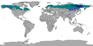
The subarctic climate is a continental climate with long, cold winters, and short, warm to cool summers. It is found on large landmasses, often away from the moderating effects of an ocean, generally at latitudes from 50°N to 70°N, poleward of the humid continental climates. Subarctic or boreal climates are the source regions for the cold air that affects temperate latitudes to the south in winter. These climates represent Köppen climate classification Dfc, Dwc, Dsc, Dfd, Dwd and Dsd.

<span class="mw-page-title-main">Caucasus Mountains</span> Mountain system at the intersection of Europe, Asia, and the Middle East

The Caucasus Mountains is a mountain range at the intersection of Asia and Europe. Stretching between the Black Sea and the Caspian Sea, they are surrounded by the Caucasus region and are home to Mount Elbrus, the highest peak in Europe at 5,642 metres (18,510 ft) above sea level.

<span class="mw-page-title-main">Temperate rainforest</span> Forests in the temperate zone

Temperate rainforests are rainforests with coniferous or broadleaf forests that occur in the temperate zone and receive heavy rain.

<span class="mw-page-title-main">Svaneti</span> Historic province of Georgia

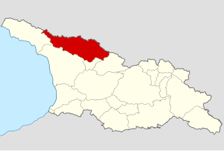
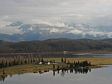
Svaneti or Svanetia is a historic province in the northwestern part of Georgia. Running along the Greater Caucasus range, Svaneti is one of the most mountainous regions of Georgia. It is largely inhabited by the Svans, an ethnic subgroup of Georgians.

<span class="mw-page-title-main">Meskheti Range</span> Mountain range in southwestern Georgia

Meskheti Range is a part of the Lesser Caucasus mountain range in Meskheti region, in southwestern Georgia.

<span class="mw-page-title-main">Trialeti Range</span>

Trialeti Range is an east-west mountain range of the Lesser Caucasus Mountains in the Samtskhe–Javakheti region of southern Georgia.

<span class="mw-page-title-main">Bzyb (river)</span> River in northwestern Abkhazia

The Bzyb or Bzipi is one of the two largest rivers of Abkhazia and the twelfth longest river in Georgia. The river valley has rich biodiversity of herbaceous garden plants, particularly in the gorge section in the upper reaches where the most prominent and colourful bellflower Campanula mirabilis with profuse growth of 100 flowers per plant is given the name, the "Queen of the Abkhazian flora". During 1904-1917 it served as the border between the Russian Empire's Sukhumi Okrug and the Black Sea Governorate.

<span class="mw-page-title-main">Mount Agepsta</span> Mountain in the Gagra Range of the Caucasus Mountains System

Mount Agepsta is a mountain in the Gagra Range of the Caucasus Mountains system located in Abkhazia, Georgia.

<span class="mw-page-title-main">Climate of Azerbaijan</span>

The climate of Azerbaijan is very diverse. Nine out of eleven existing climate zones are present in Azerbaijan.

<span class="mw-page-title-main">Caucasus mixed forests</span> Ecoregion

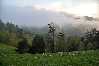
The Caucasus mixed forests is a temperate broadleaf and mixed forests ecoregion in the Caucasus Mountains, as well as the adjacent Lesser Caucasus range and the eastern end of the Pontic Mountains.

<span class="mw-page-title-main">Forests of Azerbaijan</span>

The total forest area of Azerbaijan is 1,021,880 ha or 11.8% of the country's area. The forest biomes consist of temperate deciduous forests, temperate broadleaf and mixed forests, temperate coniferous forests and riparian forests. Specialists estimate that in the 8th-9th centuries the forest cover was around 30-35%, most of it situated in mountainous areas.

<span class="mw-page-title-main">North Ossetia Nature Reserve</span> Nature reserve in North Ossetia, Russia

North Ossetia Nature Reserve is a Russian 'zapovednik' in the high mountains on the northern slope of the Caucasus Mountains with the heights ranging from 650 meters - 4,249 meters. There are 76 glaciers in the reserve with a total area of 37 km2 (14 sq mi). The site is centered on the Ardon River valley, in the Alagirsky District of North Ossetia-Alania. It was formally created in 1967, and covers a total area of 29,000 ha (110 sq mi).

<span class="mw-page-title-main">Kintrishi Strict Nature Reserve</span> Protected nature area in Georgia (country)

Kintrishi Strict Nature Reserve is a protected area in Kobuleti Municipality, Adjara region of Georgia in the upper part of the Kintrishi River at an altitude of 300–2,500 meters above sea level between the village of Tskhemvani (Tskhemlovana) and Khino Mountain in the Meskheti Range. It was established in 1959 to preserve relict humid forests and wetlands, in addition to its high number of endemic and threatened flora and fauna. Because of the ancient forests and high biodiversity within the nature reserve, it was inscribed on the UNESCO World Heritage List in 2021 as part of the Colchic Rainforests and Wetlands site.

<span class="mw-page-title-main">Liakhvi Strict Nature Reserve</span> Protected nature area in Georgia (country)

Liakhvi Strict Nature Reserve is a protected area in the historic region Shida Kartli on the southern slope of the Greater Caucasus range in the northeastern part of Tskhinvali District and in Akhalgori Municipality of Georgia. The reserve's main goal is protecting flora and fauna in surrounding mountainous region. In general Patara Liakhvi gorge has many tourist attractions : ethnological, bird-watching and botanical.

<span class="mw-page-title-main">Yalta Mountain-Forest Nature Reserve</span> Nature reserve in Crimea

Yalta Mountain-Forest Nature Reserve is a protected nature reserve that covers the southwestern ranges of the Crimean Mountains, along the south coast of the Crimean Peninsula. The reserve is in the administrative district of Yalta Municipality

Aapsta is a river in Abkhazia, Georgia. It originates on the southern slopes of the Achbikhvdar ridge in the Gudauta pass area in beech forests at 1445 meters above sea level; flows into the Black Sea between the village Tskuara (Primorskoe) and the city Gudauta.

<span class="mw-page-title-main">Egrisi Range</span> Mountain range in Caucasia

Egrisi Range, also known as the Samegrelo Range or the Odishi Range, is an east–west mountain range that runs parallel to the Greater Caucasus Mountain Range in the Samegrelo-Zemo Svaneti region of Georgia. The Range is connected to the Greater Caucasus Mountain Range via the Svaneti Range. The length of the Egrisi Range is 62 kilometres and the width is 37 kilometres. The Range is bounded by the Tskhenistsqali River Valley to the east and the Enguri River Valley to the west.

References

  1. 1 2 3 4 Hoiberg, Dale H., ed. (2010). "Abkhazia" . Encyclopædia Britannica. Vol. I: A-ak Bayes (15th ed.). Chicago, Illinois: Encyclopædia Britannica Inc. pp.  33. ISBN   978-1-59339-837-8.
  2. "Sukhumi". climatebase.ru. Retrieved 2020-04-23.
  3. "Georgia, Sukhumi climate information". Travel-climate.com. Archived from the original on 2016-03-03. Retrieved 2016-06-26.