Geography of Mongolia

Last updated

Geography of Mongolia
Mongolia CIA map.png
Map showing the major cities and the neighbouring countries of Mongolia
Continent Asia
Region East Asia
Coordinates 46°0′N105°0′E / 46.000°N 105.000°E / 46.000; 105.000
Area Ranked 18
  Total1,564,116 [1]  km2 (603,909 sq mi)
  Land99.3%
  Water0.7%
Borders Russia: 3,485 kilometres (2,165 mi)
China: 4,676 kilometres (2,906 mi)
Highest point Khüiten Peak
4,374 m (14,350 ft)
Lowest point Hoh Nuur
560 m (1,840 ft)
Longest river Orkhon River
1,124 kilometres (698 mi)
Largest lake Uvs Lake by area: 3,350 km2 (1,290 sq mi)
Khövsgöl Nuur by volume: 480.7 km3 (115.3 cu mi)
ClimateDesert; continental
TerrainVast semidesert and desert plains, grassy steppe, mountains in west and southwest
Natural resourcesOil, coal, copper, molybdenum, tungsten, phosphates, tin, nickel, zinc, fluorspar, gold, silver, iron
Natural hazardsDust storms; grassland and forest fires; drought
Environmental issuesLimited natural freshwater; the burning of soft coal for power; poor enforcement of environmental laws; severe air pollution in Ulaanbaatar; deforestation, overgrazing, soil erosion; desertification and poor mining practise

Mongolia is a landlocked country in East Asia, located between China and Russia. The terrain is one of mountains and rolling plateaus, with a high degree of relief. [2] The total land area of Mongolia is 1,564,116 square kilometres. [3] Overall, the land slopes from the high Altai Mountains of the west and the north to plains and depressions in the east and the south. [2] The Khüiten Peak in extreme western Mongolia on the Chinese border is the highest point (4,374 m (14,350 ft)). [2] The lowest point is at 560 m (1,840 ft), is the Hoh Nuur or lake Huh. [1] The country has an average elevation of 1,580 m (5,180 ft). [2]

Contents

The landscape includes one of Asia's largest freshwater lakes (Lake Khövsgöl), many salt lakes, marshes, sand dunes, rolling grasslands, alpine forests, and permanent mountain glaciers. [2] Northern and western Mongolia are seismically active zones, with frequent earthquakes and many hot springs and extinct volcanoes. [2] The nation's closest point to any ocean is approximately 645 kilometres (401 mi) from the country's easternmost tip, bordering North China to Jinzhou in Liaoning province, China along the coastline of the Bohai Sea.

Mountain regions

Altai Mountains, Sayan Mountains and Khangai Mountains Altay-Sayan map en.png
Altai Mountains, Sayan Mountains and Khangai Mountains

Mongolia has four major mountain ranges. [2] The highest is the Altai Mountains, which stretch across the western and the southwestern regions of the country on a northwest-to-southeast axis. [2] The range contains the country's highest peak, the 4,374 m (14,350 ft) high Khüiten Peak. [2]

The Khangai Mountains, mountains also trending northwest to southeast, occupy much of central and north-central Mongolia. [2] These are older, lower, and more eroded mountains, with many forests and alpine pastures. [2]

The Khentii Mountains, trending from northeast to southwest for about 400 kilometres (250 mi), occupy central Mongolia's north eastern part. The northern parts are covered in taiga, while the southern parts are filled with dry steppe. The range forms the watershed between the Arctic Ocean (via Lake Baikal) and the Pacific Ocean basins. Rivers originating in the range include the Onon, Kherlen, Menza and Tuul. [4] These mountains also house the capital of Ulaanbaatar.

The Khövsgöl Mountains occupy the north of the country. It trends from north to south and generally has a lot of steep peaks. Young mountain range with Alpine characteristics, high gradient, with narrow cliffs. [4]

Much of eastern Mongolia is occupied by a plain, and the lowest area is a southwest-to-northeast trending depression that reaches from the Gobi Desert region in the south to the eastern frontier. [2]

Rivers and lakes

Topography of Mongolia Mongolia Topography.png
Topography of Mongolia

Some of Mongolia's waterways drain to the oceans, but many finish at Endorheic basins in the deserts and the depressions of Inner Asia. [5] Rivers are most extensively developed in the north, and the country's major river system is that of the Selenge, which drains via Lake Baikal to the Arctic Ocean. [2] Some minor tributaries of Siberia's Yenisei River, which also flows to the Arctic Ocean, rise in the mountains of northwestern Mongolia. [2] In northeastern Mongolia the Onon River drains into the Pacific Ocean through the Shilka River in Russia and the Amur (Heilong Jiang) rivers, [2] forming the tenth longest river system in the world.

The southern portion of Mongolia is taken up by the Gobi Desert, while the northern and western portions are mountainous. Mongolia 1996 CIA map.jpg
The southern portion of Mongolia is taken up by the Gobi Desert, while the northern and western portions are mountainous.

Many rivers of western Mongolia end at lakes in the Central Asian Internal Drainage Basin, most often in the Great Lakes Depression, or at Hulun Lake, Ulaan Lake or Ulungur Lake. [6] The few streams of southern Mongolia do not reach the sea but run into lakes or deserts. [2]

Mongolia's largest lake by area, Uvs Lake is in the Great Lakes Depression. Mongolia's largest lake by volume of water, Lake Khövsgöl, drains via the Selenge river to the Arctic Ocean. One of the most easterly lakes of Mongolia, Hoh Nuur, at an elevation of 557 metres, is the lowest point in the country. [7] In total, the lakes and rivers of Mongolia cover 10,560 square kilometres, or 0.67% of the country. [1]

Climate

Overview

Mongolia map of Koppen climate classification zones. Koppen-Geiger Map MNG present.svg
Mongolia map of Köppen climate classification zones.

Mongolia has a high elevation, with a cold and dry climate. [2] It has an extreme continental climate with long, cold winters and short summers, during which most precipitation falls. [2] The country averages 257 cloudless days a year, and it is usually at the center of a region of high atmospheric pressure. [2] Precipitation is highest in the north, which averages 200 to 350 millimeters (7.9 to 13.8 in) per year, and lowest in the south, which receives 100 to 200 millimeters (3.9 to 7.9 in). [2] The extreme south is the Gobi Desert, some regions of which receive no precipitation at all in most years. [2] The name Gobi is a Mongol word meaning desert, depression, salt marsh, or steppe, but which usually refers to a category of arid rangeland with insufficient vegetation to support marmots but with enough to support camels. [2] Mongols distinguish Gobi from desert proper, although the distinction is not always apparent to outsiders unfamiliar with the Mongolian landscape. [2] Gobi rangelands are fragile and are easily destroyed by overgrazing, which results in expansion of the true desert, a stony waste where not even Bactrian camels can survive. [2]

Average temperatures over most of the country are below freezing from November through March and are above freezing in April and October. [2] Winter nights can drop to −40 °C (−40.0 °F) in most years. [8] Summer extremes reach as high as 38 °C (100.4 °F) in the southern Gobi region and 33 °C (91.4 °F) in Ulaanbaatar. [2] Most of Mongolia is covered by discontinuous permafrost (grading to continuous at high altitudes),[ citation needed ] which makes construction, road building, and mining difficult. [2] All rivers and freshwater lakes freeze over in the winter, and smaller streams commonly freeze to the bottom. [2] Ulaanbaatar lies at 1,351 meters (4,432 ft) above sea level in the valley of the Tuul River. [2] Located in the relatively well-watered north, it receives an annual average of 310 millimetres (12.2 in) of precipitation, almost all of which falls in July and in August. [2] Ulaanbaatar has an average annual temperature of −2.9 °C (26.8 °F) and a frost-free period extending on the average from mid-May to late August. [2]

Mongolia's weather is characterized by extreme variability and short-term unpredictability in the summer, and the multiyear averages conceal wide variations in precipitation, dates of frosts, and occurrences of blizzards and spring dust storms. [2] Such weather poses severe challenges to human and livestock survival. [2] Official statistics list less than 1% of the country as arable, 8 to 10% as forest, and the rest as pasture or desert. [2] Grain, mostly wheat, is grown in the valleys of the Selenge river system in the north, but yields fluctuate widely and unpredictably as a result of the amount and the timing of rain and the dates of killing frosts. [2]

Climate data for Ulaanbaatar city weather station (WMO identifier: 44292)
MonthJanFebMarAprMayJunJulAugSepOctNovDecYear
Record high °C (°F)−2.6
(27.3)
11.3
(52.3)
17.8
(64.0)
28.0
(82.4)
33.5
(92.3)
38.3
(100.9)
39.0
(102.2)
34.9
(94.8)
31.5
(88.7)
22.5
(72.5)
13.0
(55.4)
6.1
(43.0)
39.0
(102.2)
Mean daily maximum °C (°F)−15.6
(3.9)
−9.6
(14.7)
−0.7
(30.7)
9.7
(49.5)
17.8
(64.0)
22.5
(72.5)
24.5
(76.1)
22.3
(72.1)
16.7
(62.1)
7.6
(45.7)
−5.0
(23.0)
−13.5
(7.7)
6.4
(43.5)
Daily mean °C (°F)−21.6
(−6.9)
−16.6
(2.1)
−7.4
(18.7)
2.0
(35.6)
10.1
(50.2)
15.7
(60.3)
18.2
(64.8)
16.0
(60.8)
9.6
(49.3)
0.5
(32.9)
−11.9
(10.6)
−19.0
(−2.2)
−0.4
(31.3)
Mean daily minimum °C (°F)−25.9
(−14.6)
−22.2
(−8.0)
−13.6
(7.5)
−4.3
(24.3)
3.3
(37.9)
9.6
(49.3)
12.9
(55.2)
10.6
(51.1)
3.6
(38.5)
−4.8
(23.4)
−15.7
(3.7)
−22.9
(−9.2)
−5.8
(21.6)
Record low °C (°F)−42.2
(−44.0)
−42.2
(−44.0)
−38.9
(−38.0)
−26.1
(−15.0)
−16.1
(3.0)
−3.9
(25.0)
−0.2
(31.6)
−2.2
(28.0)
−13.4
(7.9)
−22.0
(−7.6)
−37.0
(−34.6)
−37.8
(−36.0)
−42.2
(−44.0)
Average precipitation mm (inches)2
(0.1)
3
(0.1)
4
(0.2)
10
(0.4)
21
(0.8)
46
(1.8)
64
(2.5)
70
(2.8)
27
(1.1)
10
(0.4)
6
(0.2)
4
(0.2)
267
(10.5)
Average rainy days0.10.030.227131614820.20.263
Average snowy days877730.30.20.42681059
Average relative humidity (%)78736148465460635960717862
Mean monthly sunshine hours 179.1204.8265.2262.5299.3269.0249.3258.3245.7227.5177.4156.42,794.5
Source 1: Pogoda.ru.net [9]
Source 2: NOAA (sun, 1961–1990) [10]
Climate data for Choibalsan
MonthJanFebMarAprMayJunJulAugSepOctNovDecYear
Record high °C (°F)1.3
(34.3)
8.4
(47.1)
21.4
(70.5)
29.5
(85.1)
36.8
(98.2)
41.2
(106.2)
39.1
(102.4)
38.3
(100.9)
31.6
(88.9)
28.0
(82.4)
15.2
(59.4)
3.5
(38.3)
41.2
(106.2)
Mean daily maximum °C (°F)−14.4
(6.1)
−10.7
(12.7)
−0.5
(31.1)
10.5
(50.9)
19.0
(66.2)
24.9
(76.8)
26.6
(79.9)
24.4
(75.9)
18.0
(64.4)
8.8
(47.8)
−3.4
(25.9)
−11.8
(10.8)
7.6
(45.7)
Daily mean °C (°F)−20.5
(−4.9)
−17.7
(0.1)
−7.8
(18.0)
2.6
(36.7)
11.3
(52.3)
17.6
(63.7)
19.8
(67.6)
17.9
(64.2)
10.6
(51.1)
1.5
(34.7)
−9.8
(14.4)
−17.6
(0.3)
0.7
(33.2)
Mean daily minimum °C (°F)−25.5
(−13.9)
−23.9
(−11.0)
−14.8
(5.4)
−4.1
(24.6)
3.8
(38.8)
10.8
(51.4)
14.4
(57.9)
12.1
(53.8)
4.9
(40.8)
−4.2
(24.4)
−15.2
(4.6)
−22.7
(−8.9)
−5.4
(22.3)
Record low °C (°F)−41.6
(−42.9)
−38.3
(−36.9)
−36.6
(−33.9)
−20.3
(−4.5)
−8.7
(16.3)
0.5
(32.9)
4.4
(39.9)
2.1
(35.8)
−6.0
(21.2)
−20.3
(−4.5)
−29.9
(−21.8)
−36.4
(−33.5)
−41.6
(−42.9)
Average precipitation mm (inches)1.6
(0.06)
1.9
(0.07)
2.9
(0.11)
6.3
(0.25)
14.4
(0.57)
39.0
(1.54)
57.4
(2.26)
43.3
(1.70)
27.2
(1.07)
7.7
(0.30)
3.3
(0.13)
2.6
(0.10)
207.6
(8.16)
Average precipitation days (≥ 1.0 mm)0.61.00.71.63.25.78.78.14.61.61.10.937.8
Mean monthly sunshine hours 198.5212.0266.1264.0294.9307.3297.9287.1258.2239.2199.5177.63,002.3
Source: NOAA (1961-1990) [11]

Zud

Goats that died as result of a zud Zud 2.JPG
Goats that died as result of a zud

Although winters are generally cold and clear, and livestock can survive, under various weather conditions livestock are unable to graze and die in large numbers. [2] A winter in which this occurs is known as a zud; causes include blizzards, drought, extreme cold, and freezing rain. [12] Such losses of livestock, which are an inevitable and, in a sense, normal consequence of the climate, have made it difficult for planned increases in livestock numbers to be achieved. [2]

Seasonal blizzards

Snow covers Mongolia in patches in this image from December 21, 2003. Snowfall is normally light and blows away quickly during the winter, so to see this much snow on the ground at once is rather unusual. Mongolia.A2003355.0615.500m.jpg
Snow covers Mongolia in patches in this image from December 21, 2003. Snowfall is normally light and blows away quickly during the winter, so to see this much snow on the ground at once is rather unusual.

Severe blizzards can occur in the region. The winters of 1970–1971, 2000–2001, 2008–2009 and 2009–2010 were particularly harsh, featuring extremely severe zuds.

The blizzards of December 2011 blocked many roads, and killed 16,000 livestock and 10 people. [13] [14] The Mongolian State Emergency Commission said it was the coldest winter in thirty years and, like the preceding harsh summer drought, [13] [14] could have been the result of global warming. The United Nations provided major aid due to the high level of damage caused. [15]

In the snowstorms between the 8 and 28 May 2008, 21 people were killed and 100 others went missing in seven provinces in eastern Mongolia. [16] [17] [18] The toll finally reached at least 52 people and 200,000 livestock by the end of June. [19] Most of the victims were herders who froze to death along with their livestock. [16] It was the worst cold snap since the founding of the modern state in 1922.

Snowstorms in December 2009 – February 2010 also killed 8,000,000 livestock and 60 people. [20]

Climate change

Visualisation of temperature change in Mongolia, 1901 to 2020. Temperature Bar Chart Asia-Mongolia--1901-2020--2021-07-13.png
Visualisation of temperature change in Mongolia, 1901 to 2020.

Climate change has threatened the ways of life for traditional pastoralist herders, as it is a driving factor of disruptive dzuds and gans, also known as extreme climatic events or natural disasters. Winter storms, drought periods, and extreme temperatures have become more frequent. [21] Leading up to 2000, there were approximately 20 extreme events per year, but since 2000, this number has doubled to 40 events per year. Between 2008 and 2010 Mongolia experienced 153 extreme events, most of which being strong winds, storms, and floods from run-off. [22]

Since 1940, the average year wise temperature in Mongolia has increased by at least 1.8 °C. This temperature shift is deemed responsible for an increase in grassland aridity, and as a result, a lowering of the production of biomass. The Gobi desert is expected to creep northward at approximately 6–7 km / year, which is expected to further limit pastureland. [21]

Another result of these meteorological shifts is expected to be precipitation that occurs in concentrated bursts and cannot be absorbed by the soil. The rising temperatures will also melt high mountain glaciers, degrade permafrost, and will cause more transpiration from plants. [21]

Mongolia, specifically for Ulaanbaatar's vulnerable neighborhoods, is receiving help from the European Investment Bank in converting neighborhoods vulnerable to climate change into more climate-resilient and ecological districts. Plans call for constructing 10,000 houses in 20 environmentally friendly neighborhoods with easy access to businesses and nearby employment. [23] [24] Women-led families in Mongolia will have preferential access to this new green affordable housing, and 40% of workplaces and at least 40% of green mortgage loans will go to women-led companies. [23] [24]

In April 2024, Bloomberg reported that climate change is significantly impacting Mongolia, particularly through the increasing frequency of "dzud" events, with six occurrences in the last decade causing the loss of around 5.9 million animals, or 9% of the country's livestock. The nation has experienced a temperature rise of 2.5°C over the past 80 years, exacerbating environmental degradation and economic challenges. Despite livestock production accounting for just 10% of GDP, it supports over 80% of the rural populace. The latest dzud event affected almost the entire country, resulting in a 7% increase in Mongolia's consumer price index and higher fodder costs, which also impact the vital cashmere industry. International and national initiatives are focusing on sustainable practices and renewable energy to mitigate these climate change effects. [25]

A forest in Mongolia, after a forest fire. Fire Destroyed Forest in Mongolia.jpg
A forest in Mongolia, after a forest fire.

Ecoregions

Endorheic lake in Northern Mongolia Uureg Nuur.jpg
Endorheic lake in Northern Mongolia

Resources and land use

Land use:
arable land: 9.10%
permanent crops: 0%
other: 99.61% (2011)

Irrigated land: 843 km² (2011)

Total renewable water resources: 34.8 km 3 (2011)

See also

Related Research Articles

<span class="mw-page-title-main">Selenga</span> River in Mongolia and Russia

The Selenga or Selenge is a major river in Mongolia and Buryatia, Russia. Originating from its headwater tributaries, the Ider and the Delger mörön, it flows for 992–1,024 kilometres (616–636 mi) before draining into Lake Baikal. The Selenga therefore makes up the most distant headwaters of the Yenisey-Angara river system.

<span class="mw-page-title-main">Bayankhongor Province</span> Province (aimag) of Mongolia

The Bayankhongor Province or Bayanhongor Aimag is one of the 21 aimags (provinces) of Mongolia. It is located in the southwest of the country and, at 116,000 square kilometers, it is one of the largest aimags. The capital of the aimag shares the provincial name, Bayankhongor.

<span class="mw-page-title-main">Khovd Province</span> Mongolian province

Khovd is one of the 21 aimags (provinces) of Mongolia, located in the west of the country. Its capital is also named Khovd.

<span class="mw-page-title-main">Zavkhan Province</span> Mongolian province

Zavkhan is one of the 21 aimags (provinces) of Mongolia, located in the west of the country, 1,104 km from Ulaanbaatar. Its capital is Uliastai. The aimag is named after the Zavkhan River, which forms the border between Zavkhan and Gobi-Altai aimag.

<span class="mw-page-title-main">Zud</span> Mass die-off of livestock in Mongolia

A zud, dzud of dzhut, zhut, djut, jut is a disaster in steppe, semi-desert and desert regions in Mongolia and Central Asia in which large numbers of livestock die, primarily due to starvation, being unable to graze due to particular severe climatic conditions. Various kinds of zud are recognized, depending on the particular type of climatic conditions. In winter it may be caused by an impenetrable ice crust, in summer it may happen due to drought.

<span class="mw-page-title-main">Mongolian–Manchurian grassland</span> Ecoregion in East Asia

The Mongolian-Manchurian grassland, also known as the Mongolian-Manchurian steppe or Gobi-Manchurian steppe, in the temperate grassland biome, is an ecoregion in East Asia covering parts of Mongolia, the Chinese Autonomous region of Inner Mongolia, and Northeast China.

<span class="mw-page-title-main">Gobi Desert</span> Desert in East Asia

The Gobi Desert is a large, cold desert and grassland region in northern China and southern Mongolia and is the sixth largest desert in the world. The name of the desert comes from the Mongolian word Gobi, used to refer to all of the waterless regions in the Mongolian Plateau, while in Chinese Gobi is used to refer to rocky, semi-deserts such as the Gobi itself rather than sandy deserts.

<span class="mw-page-title-main">Wildlife of Mongolia</span> Flora and fauna of Mongolia

The wildlife of Mongolia consists of flora, fauna and funga found in the harsh habitats dictated by the diverse climatic conditions found throughout the country. In the north, there are salty marshes and fresh-water sources. The centre has desert steppes. In the south, there are semi deserts as well as the hot Gobi desert in the south, the fifth-largest desert in the world.

<span class="mw-page-title-main">Saylyugemsky National Park</span>

Saylyugemsky National Park sits at the mountainous "X" where the borders of Russia, Kazakhstan, Mongolia and China meet in the Altai Mountains of central Asia. Because of its remoteness and position at the meeting points of mountains, steppes, desert and forest, it is a globally important natural reserve for biodiversity. The park was formally established in 2010–2012, with a particular purpose of protecting the vulnerable Altai argali mountain sheep and the endangered Snow leopard. The component Saylyugem Mountains are a ridge of the Altai, and stretch to the northeast to the Sayan Mountains. The climate is cold and semi-arid. Administratively, the park is located in the Kosh-Agachsky District of the Altai Republic. While ecotourism has a stated role, visits to the territory currently require special passes from park administration, and activities are limited to roads and trails.

<span class="mw-page-title-main">Transbaikal conifer forests</span> Ecoregion in southern Siberia and Mongolia

The Transbaikal conifer forests ecoregion covers a 1,000 km by 1,000 km region of mountainous southern taiga stretching east and south from the shores of Lake Baikal in the Southern Siberia region of Russia, and including part of northern Mongolia. Historically, the area has been called "Dauria", or Transbaikal. It is in the Palearctic realm, and mostly in the boreal forests/taiga biome with a subarctic, humid climate. It covers 200,465 km2 (77,400 sq mi).

<span class="mw-page-title-main">Environmental issues in Mongolia</span>

There are many pressing environmental issues in Mongolia that are detrimental to both human and environmental wellness. These problems have arisen in part due to natural factors, but increasingly because of human actions. One of these issues is climate change, which will be responsible for an increase in desertification, natural disasters, and land degradation. Another is deforestation, which is expanding due to human recklessness, pests, disease, and fires. Mongolian lands are becoming more arid through desertification, a process that is being exacerbated due to irresponsible land use. Additionally, more and more species are disappearing and at risk for extinction. Moreover, especially in population centers, Mongolians deal with air and water pollution caused by industrialization.

<span class="mw-page-title-main">Katon-Karagay National Park</span>

Katon-Karagay National Park is the largest national park in Kazakhstan, located on the eastern edge of the country, in the Southern Altai Mountains. The park fills the west side of the "X" where the borders of Kazakhstan, Russia, China, and Mongolia meet. The highest peak in Siberia, is on the Russian border in the Katun Range. The park is in Katonkaragay District of East Kazakhstan Region, 1,000 kilometres (620 mi) southeast of the capital city of Astana.

<span class="mw-page-title-main">Altai montane forest and forest steppe</span> Ecoregion in the Altai Mountains

The Altai montane forest and forest steppe ecoregion covers patches of the subalpine forest belt on the Altai Mountains, crossing the border region where Russia, Kazakhstan, Mongolia and China meet. The region has high biodiversity, as it is located in transition zones between different ecoregions, altitudes, and climate zones. It is in the Palearctic realm, with a Cold semi-arid climate. It covers 35,199,998 km2 (13,590,795 sq mi).

<span class="mw-page-title-main">Sayan montane conifer forests</span> Coniferous forests in Russia and Mongolia

The Sayan montane conifer forests ecoregion covers the mid-elevation levels of the Sayan Mountains, the high mountain range between the taiga of Siberia, Russia to the north, and the steppes of Mongolia to the south. The slopes of the mountains at the mid-altitudes are covered by Temperate coniferous forest. The ecoregion is in the Palearctic realm, with a cold semi-arid climate. It covers 35,741,835 km2 (13,800,000 sq mi).

<span class="mw-page-title-main">Selenge–Orkhon forest steppe</span> Ecoregion in Mongolia

The Selenge–Orkhon forest steppe ecoregion stretches across north central Mongolia, and follows the Selenga River northeast into Russia. The ecoregion is itself at high elevations, but surrounded by higher mountain ranges. As a transition zone between taiga and steppe, it features conifer forests on the north slopes of mountains, and pine/aspen stands on southern slopes. It has an area of 227,660 square kilometres (87,900 sq mi).

<span class="mw-page-title-main">Altai alpine meadow and tundra</span> Ecoregion in the Altai Mountains

The Altai alpine meadow and tundra ecoregion is a terrestrial ecoregion covering the higher elevation of the Altai Mountains at the center of the "X" formed by the borders separating Russia, Kazakhstan, China, and Mongolia. The mountain peaks are the farthest north in Central Asia, separating the plains of Siberia to the north from the hot, dry deserts to the south. Altitudes above 2,400 meters display characteristics of tundra, with patches of alpine meadows and some trees immediately below the treeline. The ecoregion is in the montane grasslands and shrublands biome, and the Palearctic realm, with a humid continental climate. It covers an area of 90,132 square kilometres (34,800 sq mi).

<span class="mw-page-title-main">Khangai Mountains alpine meadow</span> National park in Mongolia

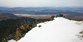
The Khangai Mountains alpine meadows ecoregion runs along the central ridge of the Khangai Mountains in central Mongolia. The slopes to the north are conifer forests, the lowlands to the south are semi-arid steppe. The Khangai are an "island" mountain range surrounded by lower forest steppe and semi-arid regions of central Mongolia. Most of the region is now protected by Tarvagatai Nuruu National Park and Khangai Nuruu National Park.

<span class="mw-page-title-main">Gobi Lakes Valley desert steppe</span> Ecoregion in Mongolia

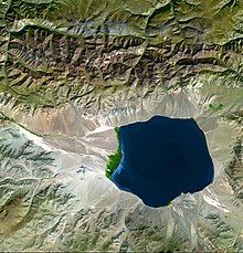
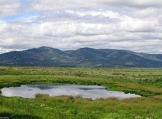
The Gobi Lakes Valley desert steppe ecoregion covers the narrow, flat valley in southwestern Mongolia that lies between the Khangai Mountains, and the Gobi-Altai Mountains. The region is known as the "Valley of the Lakes" because runoff from the mountains collect in lakes that have no outlet to the sea. Although the valley is a semi-arid desert steppe, it has areas of wetlands near the lakes that are important habit for water birds.

<span class="mw-page-title-main">Khangai Nuruu National Park</span> National park in Mongolia

Khangai Nuruu National Park stretches in a west-to-east band across the middle of the Khangai Mountains, with the eastern half following the upper Orkhon River valley. There are a variety of habitat types in the park: steppe, riparian forests, larch taiga, and alpine meadows.

References

  1. 1 2 3 PD-icon.svg This article incorporates public domain material from "Mongolia". The World Factbook (2024 ed.). CIA. 2022.  (Archived 2022 edition.)
  2. 1 2 3 4 5 6 7 8 9 10 11 12 13 14 15 16 17 18 19 20 21 22 23 24 25 26 27 28 29 30 31 32 33 34 35 36 37 PD-icon.svg This article incorporates text from this source, which is in the public domain :DeGlopper, Donald R. (1991). "The Society and Its Environment". In Worden, Robert L.; Savada, Andrea Matles (eds.). Mongolia: a country study. Washington, D.C.: Federal Research Division, Library of Congress. OCLC   622910663.
  3. "Population by sex, annual rate of population change, surface area and density" (PDF). United Nations Statistics Division. 2020. Retrieved February 12, 2022.
  4. 1 2 E, Batchuluun; G, Ymchaa; Ts, Ser-Od; Ts, Tsendsuren; L, Odmandah (2019). Газарзүй VIII (2 ed.). Ulaanbaatar, Mongolia. p. 34. ISBN   978-99978-61-09-2. Archived from the original on 2021-02-25. Retrieved 2020-06-20.{{cite book}}: CS1 maint: location missing publisher (link)
  5. "Hydrogeology of an arid endorheic basin (Tsagaan Els, Dornogobi, Mongolia): field data and conceptualization, three-dimensional groundwater modeling, and water budget - ProQuest". www.proquest.com. Retrieved 2024-05-31.
  6. "Rivers and Water". Mongolia Travel Guide. Archived from the original on 27 November 2016. Retrieved 26 November 2016.
  7. Central Asian Review, Volume 15. Central Asian Research Centre. 1967. Retrieved 26 November 2016.
  8. "Climate of the World: Mongolia | weatheronline.co.uk". www.weatheronline.co.uk.
  9. КЛИМАТ УЛАН-БАТОРА (in Russian). Pogoda.ru.net. Retrieved 4 January 2015.
  10. "Ulaanbaatar Climate Normals 1961–1990". National Oceanic and Atmospheric Administration. Archived from the original on 2017-10-10. Retrieved 4 January 2015.
  11. "Choibalsan Climate Normals 1961-1990". National Oceanic and Atmospheric Administration . Retrieved January 13, 2013.
  12. Leary, Neil; Conde, Cecilia; Kulkarni, Jyoti; Pulhin, Juan; Nyong, Anthony (2008). Climate Change and Vulnerability. Earthscan. ISBN   978-1-84977-080-4.
  13. 1 2 "Breaking News, Latest News and Videos". CNN. 2014-02-19. Archived from the original on 2013-03-24. Retrieved 2020-10-30.
  14. 1 2 "Asian Disaster Reduction Center(ADRC)". www.adrc.asia.
  15. [ permanent dead link ]
  16. 1 2 "21 dead in Mongolian snowstorms" . Retrieved 2010-01-13.[ dead link ]
  17. "Heavy snowstorm kills 21 in Mongolia - People's Daily Online". en.people.cn. Archived from the original on 2012-10-11. Retrieved 2020-10-30.
  18. "Snowstorm kills 21 in Mongolia - Thaindian News". Archived from the original on 2016-03-03. Retrieved 2010-01-13.
  19. "At least 52 dead in Mongolia snowstorm - Channel NewsAsia". Archived from the original on 2012-12-02. Retrieved 2010-01-16.
  20. "The UB Post-Leading English News - Snow Storm Casualties". Archived from the original on 2010-01-18. Retrieved 2010-01-16.
  21. 1 2 3 Taylor, Marcus (2015). The Political Ecology of Climate Change Adaptation : Livelihoods, Agrarian Change and the Conflicts of Development. Routledge. pp. Chapter 8.
  22. "REPORT ON STATE OF THE ENVIRONMENT OF MONGOLIA, 2008-2010" (PDF). Ministry of Nature, Environment and Tourism. Archived from the original (PDF) on 2020-05-08. Retrieved 2016-11-03.
  23. 1 2 "ADB to Help Ulaanbaatar Transform its Ger Areas into Eco-Districts". Asian Development Bank. 2018-08-28. Retrieved 2022-10-24.
  24. 1 2 adbheadhoncho (2018-08-24). "Ulaanbaatar Green Affordable Housing and Resilient Urban Renewal Sector Project". Asian Development Bank. Retrieved 2022-10-24.
  25. "Mongolia's Livestock Are Being Killed by Winter Climate Disasters". Bloomberg.com. 2024-04-06. Retrieved 2024-04-06.

46°00′N105°00′E / 46.000°N 105.000°E / 46.000; 105.000