This article needs additional citations for verification .(May 2007) |

The geology of Turkey is the product of a wide variety of tectonic processes that have shaped Anatolia over millions of years, a process which continues today as evidenced by frequent earthquakes and occasional volcanic eruptions.
Contents
- Background
- Geological history
- Plate tectonics
- Rocks
- Earthquakes
- See also
- External links
- Notes
- References
- Further reading

Turkey's varied landscapes are the product of a wide variety of tectonic processes that have shaped Anatolia over millions of years and continue today as evidenced by frequent earthquakes and occasional volcanic eruptions. Except for a relatively small portion of its territory along the Syrian border that is a continuation of the Arabian Platform, Turkey geologically is part of the great Alpide belt that extends from the Atlantic Ocean to the Himalaya Mountains. This belt was formed during the Paleogene Period, as the Arabian, African, and Indian continental plates began to collide with the Eurasian plate. This process is still at work today as the African Plate converges with the Eurasian Plate and the Anatolian Plate escapes towards the west and southwest along strike-slip faults. These are the North Anatolian Fault Zone, which forms the present-day plate boundary of Eurasia near the Black Sea coast, and the East Anatolian Fault Zone, which forms part of the boundary of the North Arabian Plate in the southeast. As a result, Turkey lies on one of the world's seismically most active regions.[ citation needed ]
However, many of the rocks exposed in Turkey were formed long before this process began. Turkey contains outcrops of Precambrian rocks, (more than 520 million years old; Bozkurt et al., 2000). The earliest geological history of Turkey is poorly understood, partly because of the problem of reconstructing how the region has been tectonically assembled by plate motions. Turkey can be thought of as a collage of different pieces (possibly terranes) of ancient continental and oceanic lithosphere stuck together by younger igneous, volcanic, and sedimentary rocks.

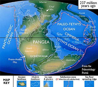
During the Mesozoic era (about 250 to 66 million years ago) a large ocean (Tethys Ocean), floored by oceanic lithosphere existed in-between the supercontinents of Gondwana and Laurasia (which lay to the south and north respectively; Robertson & Dixon, 2006). This large oceanic plate was consumed at subduction zones (see subduction zone). At the subduction trenches the sedimentary rock layers that were deposited within the prehistoric Tethys Ocean buckled, were folded, faulted, and tectonically mixed with huge blocks of crystalline basement rocks of the oceanic lithosphere. These blocks form a very complex mixture or mélange of rocks that include mainly serpentinite, basalt, dolerite and chert (e.g. Bergougnan, 1975). The Eurasian margin, now preserved in the Pontides (the Pontic Mountains along the Black Sea coast), is thought to have been geologically similar to the Western Pacific region today (e.g. Rice et al., 2006). Volcanic arcs (see volcanic arc) and backarc basins (see back-arc basin) formed and were emplaced onto Eurasia as ophiolites (see ophiolite) as they collided with microcontinents (literally relatively small plates of continental lithosphere; e.g. Ustaomer and Robertson, 1997). These microcontinents had been pulled away from the Gondwanan continent further south. Turkey is therefore made up of several different prehistorical microcontinents.[ citation needed ]
During the Cenozoic folding, faulting, and uplifting, accompanied by volcanic activity and intrusion of igneous rocks was related to major continental collision between the larger Arabian and Eurasian plates (e.g. Robertson & Dixon, 1984).
Present-day earthquakes range from barely perceptible tremors to major movements measuring five or higher on the open-ended Richter scale. Turkey's most severe earthquake in the twentieth century occurred in Erzincan on the night of December 28–29, 1939; it devastated most of the city and caused an estimated 160,000 deaths. Earthquakes of moderate intensity often continue with sporadic aftershocks over periods of several days or even weeks. The most earthquake-prone part of Turkey is an arc-shaped region stretching from the general vicinity of Kocaeli to the area north of Lake Van on the border with Armenia and Georgia.

Turkey's terrain is structurally complex. A central massif composed of uplifted blocks and downfolded troughs, covered by recent deposits and giving the appearance of a plateau with rough terrain, is wedged between two folded mountain ranges that converge in the east. True lowlands are confined to the Ergene Ovası (Ergene Plain) in Thrace, extending along rivers that discharge into the Aegean Sea or the Sea of Marmara, and to a few narrow coastal strips along the Black Sea and Mediterranean Sea coasts.[ citation needed ]
Nearly 85% of the land is at an elevation of at least 450 meters; the average and median altitude of the country is 1,332 and 1,128 meters, respectively. In Asiatic Turkey, flat or gently sloping land is rare and largely confined to the deltas of the Kızıl River, the coastal plains of Antalya and Adana, and the valley floors of the Gediz River and the Büyükmenderes River, and some interior high plains in Anatolia, mainly around Tuz Gölü (Salt Lake) and Konya Ovası (Konya Plain). Moderately sloping terrain is limited almost entirely outside Thrace to the hills of the Arabian Platform along the border with Syria.
More than 80% of the land surface is rough, broken, and mountainous, and therefore is of limited agricultural value (see Agriculture, ch. 3). The terrain's ruggedness is accentuated in the eastern part of the country, where the two mountain ranges converge into a lofty region with a median elevation of more than 1,500 meters, which reaches its highest point along the borders with Armenia, Azerbaijan, and Iran. Turkey's highest peak, Mount Ararat (Ağrı Dağı) — 5,137 meters high — is situated near the point where the boundaries of the four countries meet.