Gibney Beach

Last updated
Gibney Beach in 1998 Oppenheimer beach.jpg
Gibney Beach in 1998

Gibney Beach, or Oppenheimer Beach, is a beach on Hawksnest Bay on northern Saint John in the United States Virgin Islands. The beach's names originate from Nancy Flagg Gibney and J. Robert Oppenheimer and their families, the owners of the beach in the mid-20th century. The beach has been mostly accessible to the public since its acquisition, and a community center has been created on the property, where Oppenheimer’s house used to be.

Contents

History

The Taino inhabited St. John's north shore in the period around 1100 CE. They established one of several villages on what is now known as Hawksnest Point, between Hawksnest and Caneel Bay.

Early European settlers named this part of Hawksnest Bay "Fortuna Bay", a name that appears on Peter Lotharios Oxholm's manuscript map, drawn in 1780. This eastern shore of the Bay was part of the large Susannaberg sugar plantation at the top of the watershed. It was split off with Estate Denis Bay and 140 acres (0.57 km2) in 1906, and separated from Denis Bay in 1920. A small bay rum oil still was operational on the property in the late 19th century, and a tiny factory distilled rum from sugarcane for manufacture of the bay rum cologne. John Lindquist, owner of much of St. John's north shore in the early 20th century, planted coconuts, bananas, and other fruit trees on this property, on neighboring Denis Bay, and at his home at Cinnamon Bay.

Land area and owners

In 1950, former New York City residents Robert Gibney and his wife, Nancy Flagg Gibney, purchased the property. Robert was a writer, artist, and friend of Thomas Merton; Nancy was a feature editor for Vogue. Before the purchase, Gibney Beach was known as Hawksnest Beach. The original 40-acre (160,000 m2) parcel of land the Gibneys purchased has been divided and sold in a number of ways over the years. Some of the beach area is now part of the Virgin Islands National Park. A small piece of land, on the far northeastern section of the beach, was sold in 1957 to J. Robert Oppenheimer, an atomic scientist and member of the Manhattan Project. The house was later refurbished by the government and opened as a community center. [1]

The Gibneys

Robert and Nancy Gibney came to St. John on their honeymoon in 1946. [2] Robert was 31 at the time and Nancy was 25. They planned to spend a few months in the islands; in order to stay this extended time, Nancy had to quit her job. Robert planned to write a novel while in the islands. [3] The Gibneys rented a small cottage on Cruz Bay Beach. Later, when friends Julius and Cleome Wadsworth, who lived on Denis Bay, moved back to the United States for the summer, the Gibneys stayed in their home rent-free. When the Wadsworths returned the next winter, the Gibneys were not yet ready to leave, so they moved into a shed on Henley Cay, an 11-acre (45,000 m2) island on Caneel Bay. [2] At the time this was the only housing available, and the Gibneys ended up living there for the next three years. In 1950 Robert's father died and left Robert and Nancy enough money to buy land on St. John. They purchased 40 acres (160,000 m2) of land on Hawksnest Bay and made it their own. Their house was built in the center of the beach from rocks found on site. Gibney Beach became home to Robert, Nancy, and their three children. Robert home-schooled all three. [2] He worked for Caneel Bay during the expansion of the resort in the 1950s. In the 1960s he became a librarian in Cruz Bay. Nancy wrote short stories. Women's magazines such as McCall's and Redbook published her works. [3]

Robert died in 1973 and Nancy in 1980; both are interred in a Cruz Bay cemetery. The couple left the beach property to their children; the land was divided among them. Ed Gibney, their firstborn child, is a lifelong resident of Saint John and works as a surveyor. [3] His sister Eleanor is on the board of the St. John Historical Society. She too is a lifelong resident on St. John, having grown up on her family's beachfront property. For 15 years she worked for the Caneel Bay Resort, becoming the chief horticulturalist. She is the author of A Field Guide to Native Trees and Plants of East End, St. John U.S. Virgin Islands. She married Gary Ray and they have two children. [3] The Gibneys' second son, John, died in 2003. He lived on Gibney Beach, planting and tending to a garden of tropical trees. John Gibney's remains are interred on the property within his garden. [1]

The Oppenheimers

After living on the beach for seven years, the Gibneys were forced to sell part of their land to J. Robert Oppenheimer in 1957 due to financial problems. Oppenheimer is known as "the father of the atomic bomb". The Gibneys sold the most northeastern part of the land to Oppenheimer and his wife, Kitty, who built a vacation home. After their death, the Oppenheimers left the land to their daughter, Toni. Toni died in 1976 and left the property to "the people of St. John". The land is now a public park. [2] The house was left in disrepair and frequently vandalized until the Virgin Islands government took over the property and created a community center. Now, the center can be rented out by paying a small fee for such events as senior citizen outings, Boy Scout meetings, concerts, picnics, weddings, and birthday parties. [2]

Property dispute

The Gibneys' property sale to the Oppenheimers created significant controversy between the families and the local community.

To avoid overdevelopment, the Gibneys had a series of deed restrictions placed on the selling of their land. The deed restricted the property to a one-family dwelling. To preserve the natural environment, the Gibneys had to approve the placement of any structure. They also placed deed restrictions that prohibited rental of the property. And they had the right to repurchase the property if and when the Oppenheimers wanted to sell the land. This first right of refusal was the most important part of the deed to the Gibneys. At first, the Gibneys' deed did not seem to restrict the Oppenheimers, but they began renting their vacation cottage soon after it was built, through the local real estate agency. The Gibneys disapproved, and the Oppenheimers argued the tenants they were renting to were "just friends of theirs". When Robert Oppenheimer died, Kitty began construction on a tool shed on the property line between the Gibneys and the Oppenheimers, and was too close to the beach according to the Gibneys. That Christmas, both buildings the Oppenheimers built were again rented to friends. A number of lawsuits followed, and the Virgin Islands Police Department was called to intervene on several occasions. [4]

After Kitty died, the Oppenheimers' land was left to their daughter Toni. Toni later died by suicide and left the land to "the people of St. John for a public park and recreation". The Gibneys rejected the idea of a public park and expressed to Robert Meyner, Toni's executor to estate, their right of first refusal. In Meyner's responses he declared that their right of first refusal applied only to a sale, not a donation. The Gibneys fought back, warning Meyner they would engage in a new deed saying only a one-family residence could be built. Meyner responded that there would be no need for future buildings. [4]

Even with the deterioration of the building and property after Toni's death, the Gibneys persisted in their fight. They wanted to regain control of the property, but faced numerous delays. When Robert Gibney died in 1973, Nancy kept fighting. She died in 1980 with the conflict unresolved. The National Park Beach took over the property at Hawksnest Beach and a parking lot, changing area, pit toilets, barbecue grills, tables, benches, and sheltered pavilions were added. The beach's visiting population grew. The land became known as Hawksnest Beach and the smaller section Gibney Beach. The Virgin Islands government took ownership of the Oppenheimers' land. They renovated the house and made improvements to the land; it is now a community center. A large iron gate was placed at the entrance to the Gibneys' property on the North Shore Road to prevent cars from entering. Two driveways serve as the entrances to the Gibneys' private property. [4]

National Park Service

Today, much of Gibney Beach is under the stewardship of the United States Virgin Islands National Park. The 2 acres (8,100 m2) of the waterfront land were the first major acquisition by the Virgin Islands National Park since January 4, 1979, when it acquired the Annaberg estate. On August 15, 1997, Robert and Nancy Gibney's children optioned their portion of the beachfront property to The Trust of Public Land, an organization working in partnership with The Friends of the Virgin Islands National Park. Friends is a nonprofit organization dedicated to protecting and preserving the natural and cultural resources of the Virgin Islands’ National Parks. As the official private sector partner to the Park, Friends is a membership organization that raises funds from individuals, corporations, and foundations to supplement the Park's budget. [5] At the time, the remaining 5 acres (20,000 m2) of the Gibneys' land was valued at over $3.5 million. The Gibneys were not concerned about the money; they agreed to sell the land to the Trust for less than the market price. It became clear that without creative compromise, there would not be adequate resources to compensate Ed and Eleanor Gibney. Consequently, Ed agreed to subdivide his property to include all of his beachfront but somewhat less than his total acreage. Eleanor agreed to retain a right to remain on her property for 30 years in exchange for the reduced price. [5]

Wildlife

St. John has 140 species of birds, 302 species of fish, 7 species of amphibians, 22 species of mammals, and 740 species of plants. There are also about 50 coral species, many gorgonians, and sponges. The only mammal native to Saint John is the bat, but many non-native animals have been introduced to the island over the years, such as dogs, cats, donkeys, sheep, deer, and pigs. [6]

Plant life

Inside the forests off the shore of Gibney Beach, there is also an abundance of plant life. Gibney Beach lies on the eastern coast of the island and is characterized by dry forest vegetation. Cacti such as the barbed-wire cactus ( Acanthocereus tetragonus ), prickly pear ( Opuntia spp.), organ pipe cactus ( Pilosocereus royenii ), and Turk's cap cactus ( Melocactus intortus ) are prominent in the area. These cacti grow alongside shrubs, such as maran (Croton flavens var. rigidula), and thorn bushes like casha ( Acacia tortuosa ) and catch-and-keep (Acacia retusa). The thorny nature of these forests make them difficult to navigate. Mangrove forests can also be found off Gibney Beach. Mangrove trees alter the shoreline, changing salinity, tidal inundation and oxygenation of the soil. Red mangroves ( Rhizophora mangle ) are the most common and grow in the ocean. They have specialized prop roots that protect shorelines and serve as nurseries for many marine animals. Other mangrove species that can be found on the coast are the black mangrove ( Avicennia germinans ), white mangrove ( Laguncularia racemosa ), and buttonwood mangrove ( Conocarpus erectus ). [7] Other more exotic trees can be found in residential areas off Gibney Beach. Gardens often include orchids, heliconia, ylang-ylang trees, and fruit trees such as coconut, star fruit, bananas, and mango. [8]

On the coast

The coast of Gibney Beach is also full of wildlife. The sand that makes up Gibney beach is made primarily from two sources, marine algae and living coral reefs. Sea turtles occasionally visit the beach to lay eggs. Sandpipers and other shore birds are often on the beach, searching for small crabs and mollusks that live beneath the sand. [7]

A view from the ocean on Gibney Beach. A view from the ocean on Gibney Beach.jpg
A view from the ocean on Gibney Beach.

Ocean life

Gibney Beach is not a big attraction for snorkelers because much of the marine life off Gibney Beach was significantly damaged during a heavy rain during the excavation for the Myrah Keating Smith Clinic. Soil was washed down into the bay and resulted in turbidity that damaged much of the coral life in the bay. The coral reefs are slowly coming back to life, bringing more animal marine life with them. [1]

Gibney Beach's reefs include brain coral, elkhorn, staghorn, pillar coral, boulder coral, and fire coral. These are colorful and contain a variety of fish and other aquatic creatures. Atop these large coral bodies sit sea fans, sea whips and sea plumes. [7]

Common fish off Gibney Beach include goatfish, grunts, tangs, parrotfish, angelfish, squirrelfish, trunkfish, trumpetfish, yellowtail snapper, blue runners, groupers, butterflyfish, damselfish, squirrelfish, porcupinefish, wrasses, octopuses, and eels. The reefs also house a number of invertebrates, including sponges, starfish, sea urchins, sea worms, crabs, lobsters, and sea anemones. [1] [7]

Tourism

Gibney Beach is on North Shore Road (Route 20), about 2.1 miles (3.4 km) from Mongoose Junction in downtown Cruz Bay. There are no signs that lead to Gibney, no parking, and no facilities. There is only a small gravel road leading down to the beach, blocked off by a tall white gate to keep cars out. There is a small opening in the gate allowing entrance by foot. In front of the gate, a small portion of the road is open where about four cars will tightly fit. Even though it is open to the public, the beach has a very private feel.

Gibney Beach neighbors Hawksnest Beach. The entrance is the third driveway on the left if passing Hawksnest. To the right of the driveway is the Oppenheimer part of the beach. The southwestern part is Gibney. While they are nearly the same beach, the Oppenheimer house is open to the public but the Gibney house sections are private. In the Virgin Islands, public domain property is from the sea to the first line of vegetation. Behind the first line of vegetation, the Gibney Beach property belongs to the Gibney family.

Villas

Two villas on the beach are available for rent by visitors and tourists: the Gibney Garden Cottage and the Gibney Beach Cottage, both directly on the beach. The cottages can be rented separately or together. Botanical gardens surrounding the villas are filled with orchids, heliconia, ylang ylang trees and fruit trees consisting of exotic plants and fruits, including coconuts and star fruit. [8]

Gibney beach has limited parking, and there are no hotels or condos to rent on the land. A few homes within easy walking distance of Gibney Beach are popular with visitors and tourists. Tourists also have a scenic and easy drive on paved roads into shops and restaurants of Cruz Bay nearby. [9]

Activities

For simply relaxing on the beach and enjoying the nature of St. John, many people, both tourists and locals alike, visit Gibney Beach for its quieter atmosphere. This private, “off-the-beaten-path” quality of Gibney Beach is because there are no water sport rentals, eateries, and only limited parking available. [9] Sea grape trees and palms line the shore creating shade. There are tree-covered picnic tables for those who wish to bring their own meal and enjoy family and friends at the beach. There is no admission charge at Gibney Beach. [10]

Snorkeling

Although it is not the favored snorkeling area in St. John, the most popular activity at Gibney Beach is snorkeling. This is due to the accessibility of waters and the waters’ appropriate conditions for the most novice to advanced snorkeling. [10] The snorkeling here is also popular because of the vast array of coral and fish that are visible on the fringing reef in the area. In addition to the plants and animals, there is a sunken sailboat that is accessible to explore while snorkeling. The best snorkeling here is during the summer. [1]

The Community Center at Gibney Beach was once the home of the Oppenheimer family. Now this portion of the beach is public and offers the best access to the reef. Here, the white sand is soft and the water is shallow and ideal for beginners. For more advanced snorkeling, one can continue north on the eastern coastline to Perkins Cay and Denis Bay. The deeper waters range from six to ten feet deep. [1] [10]

Much of the colorful reef life is very close to the shore. It is possible to see sections of boulder, fire, brain, and elkhorn coral. Spottings of both small and medium schools are fish are common. The fish close to the shore, visible while snorkeling, include: parrotfish, squirrelfish, trunkfish, trumpetfish, goatfish, grunt, and tang. There are also predator fish like the yellowtail snapper and the blue runner. [1]

Local entertainment

Local reggae and calypso bands sometimes perform at Gibney Beach at the Community Center. [1]

Related Research Articles

<span class="mw-page-title-main">Fitzroy Island National Park</span> Protected area in Queensland, Australia

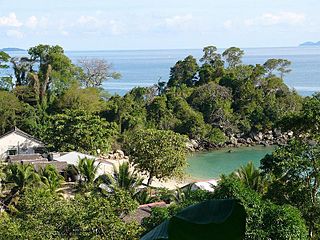
Fitzroy Island National Park is a gazetted protected area covering Fitzroy Island, in Far North Queensland, Queensland, Australia. Fitzroy Island, is a continental island located 22 kilometres (14 mi) east of Cairns on the mainland.

<span class="mw-page-title-main">Biscayne National Park</span> American national park located south of Miami, Florida

Biscayne National Park is an American national park located south of Miami, Florida in Miami-Dade County. The park preserves Biscayne Bay and its offshore barrier reefs. Ninety-five percent of the park is water, and the shore of the bay is the location of an extensive mangrove forest. The park covers 172,971 acres and includes Elliott Key, the park's largest island and northernmost of the true Florida Keys, formed from fossilized coral reef. The islands farther north in the park are transitional islands of coral and sand. The offshore portion of the park includes the northernmost region of the Florida Reef, one of the largest coral reefs in the world.

<span class="mw-page-title-main">Virgin Islands National Park</span> 14,700 acres in St. John, Virgin Islands (US) managed by the National Park Service

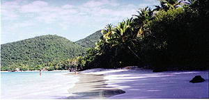
The Virgin Islands National Park is an American national park preserving about 60% of the land area of Saint John in the United States Virgin Islands, as well as more than 5,500 acres of adjacent ocean, and nearly all of Hassel Island, just off the Charlotte Amalie, Saint Thomas harbor.

<span class="mw-page-title-main">Saint John, U.S. Virgin Islands</span> One of the main islands of the United States Virgin Islands

Saint John is one of the Virgin Islands in the Caribbean Sea and a constituent district of the United States Virgin Islands (USVI), an unincorporated territory of the United States.

The Virgin Islands Coral Reef National Monument is a U.S. National Monument located off Saint John, Virgin Islands.

<span class="mw-page-title-main">Salt River Bay National Historical Park and Ecological Preserve</span> National Park Service unit in the U.S. Virgin Islands

Salt River Bay National Historic Park and Ecological Preserve is a unit of the National Park Service on the island of St. Croix in the U.S. Virgin Islands. It preserves upland watersheds, mangrove forests, and estuarine and marine environments that support threatened and endangered species. It also contains the Columbus Landing Site, a National Historic Landmark that is the only known site where members of a Columbus expedition set foot on what is now United States territory. The site is marked by Fort Salé, a remaining earthworks fortification from the French period of occupation, about 1617. The park also preserves prehistoric and colonial-era archeological sites including the only existing example of a ball court in the US Virgin Islands.

<span class="mw-page-title-main">Caneel Bay</span> Point of interest on the island of St. John, USVI

Caneel Bay was a resort set on a 170-acre peninsula in the Virgin Islands National Park. The resort, near picturesque beaches, is a vacation destination in the Caribbean. It is located on the northwest side of St. John, US Virgin Islands. The resort is within Virgin Islands National Park, on property once owned by Laurance Rockefeller, and operates under a unique agreement with the US National Park Service. The RUE agreement enables the resort to operate with a unique tax-free, rent-free status since 2004.

<span class="mw-page-title-main">Trunk Bay</span> Body of water in the U.S. Virgin Islands

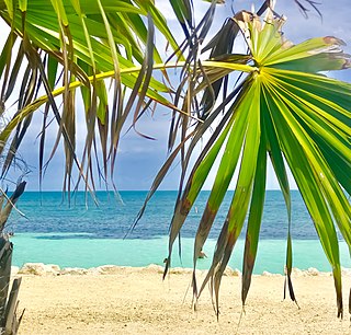
Trunk Bay is a body of water and a beach on St. John in the United States Virgin Islands. Trunk Bay is part of the Virgin Islands National Park. Trunk Bay is named for the Leatherback turtle, which is endemic to the USVI and are locally known as trunks. The beach area is divided into two halves, the main Trunk Bay beach and swim area and Burgesman Cove which is located on the west end of Trunk Bay near Jumby Bay. Its amenities include a snack bar, showers and restrooms, a lifeguard, and an underwater trail for snorkeling its coral reef. Trunk Bay has consistently been voted one of the top beaches in the world.

<span class="mw-page-title-main">Magens Bay</span>

Magens Bay is a bay in the Northside region on Saint Thomas, United States Virgin Islands, in the Caribbean.

Tumon Bay is a bay in the United States territory of Guam, opening to the Philippine Sea. It is bounded to the north by Two Lovers Point and to the south by Ypao Point. The entirety of the bay falls within the Tumon Bay Marine Preserve, also known as the Tumon Bay Marine Preserve Area (MPA) and Tumon Preserve, one of five marine preserves on Guam. The Preserve measures 4.54 square kilometers and is roughly two miles long. The platform of the fringing reef that separates the open ocean from the lagoon is up to 1,450 feet (440 m) wide. and up to one mile from the shore. The bay is located off of the Tumon area, the tourist center of the island, in the village of Tamuning. The bay is extensively utilized for recreation and fishing.

<span class="mw-page-title-main">Bahia Honda Key</span> Island in Florida, United States

Bahia Honda is an island in the lower Florida Keys.

Waterlemon Cay is a small cay surrounded by a fringing reef located in Leinster Bay on Saint John, U.S. Virgin Islands. It is named after the water lemon.

<span class="mw-page-title-main">San Andrés (island)</span> One of the two principal islands of San Andrés and Providencia, Colombia

San Andrés is a coral island in the Caribbean Sea. Politically part of Colombia, and historically tied to the United Kingdom, San Andrés and the nearby islands of Providencia and Santa Catalina form the department of San Andrés, Providencia and Santa Catalina. San Andrés, in the southern group of islands, is the largest of Colombia. The official languages of the department are Spanish, English, and San Andrés–Providencia Creole.

<span class="mw-page-title-main">Ankify</span> Place in Antsiranana, Madagascar

Ankify is a peninsula located in the district of Ambanja, region of Diana in northern Madagascar. It is located at 13°32′10″S48°21′15″E and faces Nosy Be and Nosy Komba islands. A small harbor allows boardings to these destinations. At its very north end, the village named Doany is bordered by a coral reef.

<span class="mw-page-title-main">Tropical salt pond ecosystem</span> Buffer zone between terrestrial and marine ecosystems

Salt ponds are a natural feature of both temperate and tropical coastlines. These ponds form a vital buffer zone between terrestrial and marine ecosystems. Contaminants such as sediment, nitrates and phosphates are filtered out by salt ponds before they can reach the ocean. The depth, salinity and overall chemistry of these dynamic salt ponds fluctuate depending on temperature, rainfall, and anthropogenic influences such as nutrient runoff. The flora and fauna of tropical salt ponds differ markedly from those of temperate ponds. Mangrove trees are the dominant vegetation of tropical salt pond ecosystems, which also serve as vital feeding and breeding grounds for shore birds.

<span class="mw-page-title-main">Fauna of the United States Virgin Islands</span>

The fauna of the United States Virgin Islands consists of 144 species of birds, 22 species of mammals, 302 species of fish and 7 species of amphibians. The wildlife of the U.S.V.I. includes numerous endemic species of tropical birds, fish, and land reptiles as well as sea mammals. The only endemic land mammals are six species of native bats: the greater bulldog bat, Antillean fruit-eating bat, red fruit bat, Brazilian free-tailed bat, velvety free-tailed bat and the Jamaican fruit bat. Some of the nonnative land mammals roaming the islands are the white-tailed deer, small Asian mongoose, goats, feral donkeys, rats, mice, sheep, hogs, dogs and cats.

The St. Croix East End Marine Park (STXEEMP) was established to "protect territorially significant marine resources, and promote sustainability of marine ecosystems, including coral reefs, sea grass beds, wildlife habitats and other resources, and to conserve and preserve significant natural areas for the use and benefit of future generations." It is the U.S. Virgin Islands’ first territorially designated and managed marine protected area (MPA).

Oil Nut Bay is a coral reef bay situated on the northeast coast of Virgin Gorda in the British Virgin Islands, about 1 kilometre (0.62 mi) west of Pajaros Point.

<span class="mw-page-title-main">Coral reefs of the Virgin Islands</span> Marine ecosystems found in the Virgin Islands

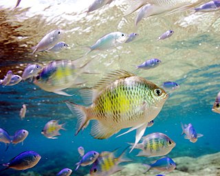
One of the marine ecosystems found in the Virgin Islands are the coral reefs. These coral reefs can be located between the islands of St. Croix, St. Thomas, and St. John. These coral reefs have an area of 297.9 km2, along with other marine habitats that are in between. The way these coral reefs grow are by coral larvae swimming freely and attaching themselves to hard surfaces around the islands and start to develop a skeleton on the outside of their skin to protect themselves from predators but also allow a new place for other coral larvae to attach to and grow on. These corals can form into three different structures; fringing reefs, which are reefs that are close to the shore, barrier reefs, which are reefs that are alongside the shore and is separated by deep water, and an atoll reef which is a coral reef that circles a lagoon or body of water.

<span class="mw-page-title-main">Piti Bomb Holes Marine Preserve</span>

Piti Bomb Holes Marine Preserve is a marine protected area comprising all of Piti Bay on the western coast of Guam, located off of the village of Piti in the Philippine Sea. The defining "bomb hole" features, named because they look like bomb craters in the reef flat, are actually natural percolation pits where fresh water filters into the shallow lagoon at a depth of 25 to 30 feet. The largest pit houses the commercial Fish Eye Marine Park tourist attraction, which includes a wooden pier to a underwater observatory and a Seawalker tour of the lagoon bottom. It is visited by more than 200,000 people annually. The Piti preserve is the most ecologically diverse of Guam's five marine preserves. The pit around Fish Eye is a popular snorkeling and recreational diving site.

References

  1. 1 2 3 4 5 6 7 8 "St John Beach Guide". Archived from the original on 2007-10-13. Retrieved 2007-10-20.
  2. 1 2 3 4 5 "See St. John" . Retrieved 2007-10-20.
  3. 1 2 3 4 "St John Historical Society". Archived from the original on 2011-07-28. Retrieved 2007-10-05.
  4. 1 2 3 "Oppenheimer Beach". St. John History. Archived from the original on 2015-07-17. Retrieved 2007-10-30.
  5. 1 2 "Friends of Virgin Islands National Park Newsletter". Archived from the original on 2007-04-16. Retrieved 2007-10-01.
  6. "Nature and Science" . Retrieved 2007-10-15.
  7. 1 2 3 4 "Friends of VINP". Archived from the original on 2007-06-25. Retrieved 2007-10-17.
  8. 1 2 "Gibney Villas". Archived from the original on 2006-11-08. Retrieved 2007-10-17.
  9. 1 2 "Hawksnest". Archived from the original on 2007-10-20. Retrieved 2007-10-12.
  10. 1 2 3 "Abroad at Gibney". Archived from the original on 2011-07-12. Retrieved 2007-10-12.

18°21′09″N64°46′35″W / 18.35250°N 64.77639°W / 18.35250; -64.77639