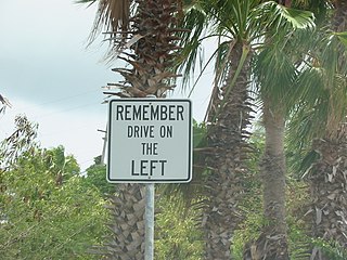
The United States Virgin Islands (USVI) is the only place under United States jurisdiction where the rule of the road is to drive on the left. However, virtually all passenger vehicles are left hand drive due to imports of U.S. vehicles.

Charlotte Amalie, located on St. Thomas, is the capital and the largest city of the United States Virgin Islands. It was founded in 1666 as Taphus. In 1691, the town was renamed to Charlotte Amalie after Charlotte Amalie of Hesse-Kassel (1650–1714), queen consort to King Christian V of Denmark-Norway. It has a deep-water harbor that was once a haven for pirates and is now one of the busiest ports of call for cruise ships in the Caribbean, with about 1.5 million-plus cruise ship passengers landing there annually. Protected by Hassel Island, the harbor has docking and fueling facilities, machine shops, and shipyards and was a U.S. submarine base until 1966. The Town has been inhabited for centuries. When Christopher Columbus arrived in 1493, the area was inhabited by Caribs, Arawaks, Ciboney and Taíno native peoples. It is on the southern shore at the head of Saint Thomas Harbor. In 2010 the City had a population of 18,481, which makes it the largest city in the Virgin Islands Archipelago. Hundreds of ferries and yachts pass by the Town each week.

The Port of Miami, styled as "PortMiami" but formally the Dante B. Fascell Port of Miami, is a major seaport located in Biscayne Bay at the mouth of the Miami River in Miami, Florida. It is the largest passenger port in the world, and one of the largest cargo ports in the United States.

Cinnamon Bay is a body of water and a beach on St. John island, within Virgin Islands National Park, in the United States Virgin Islands.

Great Stirrup Cay is a 268-acre (108 ha) island that is part of the Berry Islands in the Bahamas. Norwegian Cruise Line purchased the island from the Belcher Oil Company in 1977 and developed it into a private island for their cruise ship passengers. The northern part of the island has a sandy beach surrounded by rocks with snorkeling areas. The southern part features a helicopter airfield, a large area without vegetation, and numerous concrete blocks. These are all remnants of a previous U.S. military installation and satellite tracking station. The island's lighthouse was originally constructed in 1863 by the Imperial Lighthouse Service. Great Stirrup Cay is adjacent to Little Stirrup Cay, Royal Caribbean Cruises' private island.

Mount Sage National Park is a protected area of the British Virgin Islands. It is named after the highest peak of the island of Tortola, Mount Sage. The Mount Sage volcanic peak rises to a height of 1,716 feet (523 m), and is thus the highest point in all of the Virgin Islands. The park is located to the southwest of the island group's capital, Road Town. The park, which includes the mountain range, extends over an area of 96 acres (39 ha). The vegetation is of semi-rain forest type. There are many trails for trekking and hiking.
La Rosette is a settlement in Guadeloupe in the commune of Le Moule, on the island of Grande-Terre. It is located to the west of Lemercier and to the south of Palais-Sainte-Marguerite.
Tourism in Haiti is an industry that has generated just under a million arrivals in 2012, and is one of the main sources of revenue for the nation. With its favorable climate, second longest coastline of beaches and most mountainous ranges in the Caribbean, waterfalls, caves, colonial architecture and distinct cultural history, Haiti has had its history as an attractive destination for tourists. However, unstable governments have long contested its history and the country's economic development throughout the 20th century.
The Old Market of Roseau, also known as Old Market Plaza and Dawbiney Market Square, is a market located in Roseau, the capital of the Caribbean island of Dominica. Located behind what is today The Dominica Museum on the seafront, it was a thriving market during colonial times and the square was the place where all the major trading between Dominica and the surrounding islands took place, from commodities to slave trading. Public executions were held here. In 1988, the square was renovated as a craft center with shops, to display Dominica crafts. Today it contains stalls selling handcrafted jewelry, T-shirts, spices etc.

Catedral de Nuestra Señora de La Asunción is the seat of the Roman Catholic Diocese of Margarita and is located in La Asunción, Nueva Esparta state, on Margarita Island, Venezuela. Completed in 1571, it is the oldest church in Venezuela.
Divi Flamingo Beach Resort & Casino is a diving resort hotel and casino on the Caribbean island of Bonaire. The grounds include a scuba centre, bars, restaurants and casino reported to be the world's first "barefoot casino". The hotel has 141 rooms. The headquarters for Divi Resorts is located in Chapel Hill, NC.

Piscadera Bay is a waterway and a neighbourhood in the Netherlands Antilles. It is situated at the western side of Otrobanda, in the southern part of Willemstad, the capital of the southern Caribbean island of Curaçao. It contains a fort of the same name, the Caribbean Marine Biological Institute, and several hotels. It has a small beach, as well as a vacation village and holiday resort, with tennis courts and casinos. Sint Anna Bay is nearby. In the 17th century, maps of Piscadera Bay showed it to be a popular locale for fishing, with over 400 different species noted.
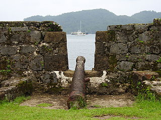
The fortifications on the Caribbean Side of Panama: Portobelo-San Lorenzo are military constructions, built by the Spanish Empire during the 17th and 18th centuries on the Caribbean coastline of Colón Province in Panama. The ruins are located on the coast of the province of Colón. In view of their cultural importance, the sites have been inscribed by UNESCO in 1980 as a World Heritage Site under Criteria (i) and (iv), with the description, "Magnificent examples of 17th- and 18th-century military architecture, these Panamanian forts on the Caribbean coast form part of the defence system built by the Spanish Crown to protect transatlantic trade."

Cas Cay is a fifty-acre (200,000-square-metre) undeveloped island, situated a mile south of Red Hook on the eastern side of Saint Thomas in the United States Virgin Islands. It is under the protection of the Department of Natural Resources. Ferries here depart from Compass Point Marina, right east of Nadir.

Steven Cay is a small scrub-covered and rocky Caribbean island, about 28 feet high and situated 0.5 miles west of Cruz Bay on Saint John in the United States Virgin Islands. It is a popular destination for snorkelers and scuba divers,.

Whistling Cay is a 19-acre (7.7 ha) islet, situated 300 yards (270 m) west of Mary Point on Saint John in the United States Virgin Islands. It is covered with trees and high cliffs in the north, where it reaches a 130-foot (40 m) elevation. A gravel beach is located on the southeast side of the island. It is separated from Saint John by the Fungi Passage, which has a depth of 21 feet (6.4 m).
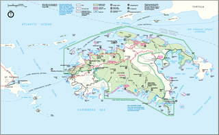
Leduck Island is an island in the United States Virgin Islands, also spelled LeDuck Island, which is located 0.5 miles east of Sabbat Point in Johns Folly, separated from Saint John by the Sabbat Channel. LeDuck Island lies by the entrance to Coral Bay and is 85 feet high. Leduck Island is located within the Virgin Islands National Park and is one of the largest offshore islands to Saint John, along with Grass Cay and Congo Cay.
Cinnamon Cay is a cay in the United States Virgin Islands, situated approximately 0.7 miles east of Trunk Cay in the Cinnamon Bay, and 100 yards from the shore at Cinnamon Bay Beach on Saint John island. It has a height of 32 feet. The islet is uninhabited, but regularly visited by scuba-divers, snorkelers and kayakers. Cinnamon Bay Watersports offers kayaks and snorkeling equipment for travelers to the cay. Cinnamon Cay is mostly covered with grass and cactus, and is located within the Virgin Islands National Park.

East End is an administrative subdistrict of the island of St. Thomas in the United States Virgin Islands. The largest community is Red Hook, while smaller communities include Benner, Nazareth, Nadir, Frydendal, and Smith Bay. The subdistrict includes the offshore islands of Great Saint James, Little Saint James, Bovoni Cay, Patricia Cay, Cas Cay, Rotto Cay, Thatch Cay, Shark Island, and Dog Island.
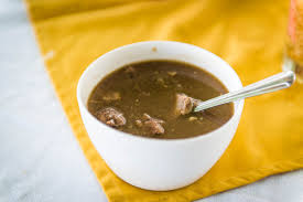
Goat water, also referred to as kiddy stew, is a stew that is a part of the national cuisine of the Caribbean island of Montserrat It has been described as a national dish of Montserrat. It has also been described as a national stew.


