Governador Celso Ramos

Last updated
Governador Celso Ramos
Municipality
Bandeira GovernadorCelsoRamos.png
Brasao do municipio de Governador Celso Ramos (SC).png
Brazil location map.svg
Red pog.svg
Governador Celso Ramos
Location in Brazil
Coordinates: 27°18′54″S48°33′32″W / 27.315°S 48.5589°W / -27.315; -48.5589 Coordinates: 27°18′54″S48°33′32″W / 27.315°S 48.5589°W / -27.315; -48.5589
CountryFlag of Brazil.svg  Brazil
Region South
State Santa Catarina
MesoregionGrande Florianópolis
Population
 (2020 [1] )
  Total14,606
Time zone UTC−3 (BRT)
Website governadorcelsoramos.sc.gov.br

Governador Celso Ramos is a municipality in the state of Santa Catarina in the South region of Brazil. [2] [3] [4] [5]

The municipality contains part of the 17,104 hectares (42,260 acres) offshore Marinha do Arvoredo Biological Reserve, a fully protected conservation unit established in 1990. [6]

See also

Related Research Articles

Biguaçu is a municipality in the state of Santa Catarina in the South region of Brazil.

Schroeder (Schröder) is a municipality in the state of Santa Catarina in the South region of Brazil.

<span class="mw-page-title-main">Maravilha, Santa Catarina</span> Municipality in South, Brazil

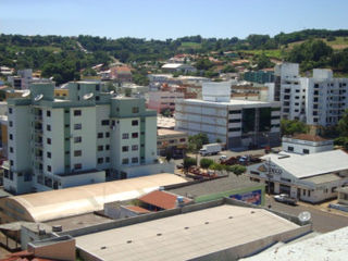
Maravilha, Santa Catarina is a municipality in the state of Santa Catarina in the South region of Brazil. It was created in 1958 out of the existing municipality of Palmitos.

Planalto Alegre is a municipality in the state of Santa Catarina in the South region of Brazil.

Saltinho, Santa Catarina is a municipality in the state of Santa Catarina in the South region of Brazil.

<span class="mw-page-title-main">Ouro Verde, Santa Catarina</span> Municipality in South, Brazil

Ouro Verde, Santa Catarina is a municipality in the state of Santa Catarina in the South region of Brazil.

<span class="mw-page-title-main">Tunápolis</span> Municipality in South, Brazil

Tunápolis is a municipality in the state of Santa Catarina in the South region of Brazil.

Bandeirante is a municipality in the state of Santa Catarina in the South region of Brazil.

<span class="mw-page-title-main">Sul Brasil</span> Municipality in South, Brazil

Sul Brasil is a municipality in the state of Santa Catarina in the South region of Brazil. It was created in 1961 by division of the municipality of Modelo.

Riqueza is a municipality in the state of Santa Catarina in the South region of Brazil.

Tigrinhos is a municipality in the state of Santa Catarina in the South region of Brazil.

Arvoredo is a municipality in the state of Santa Catarina in the South region of Brazil.

<span class="mw-page-title-main">Erval Velho</span> Municipality in South, Brazil

Erval Velho is a municipality in the state of Santa Catarina in the South region of Brazil.

Rio das Antas is a municipality in the state of Santa Catarina in the South region of Brazil.

Salto Veloso is a municipality in the state of Santa Catarina in the South region of Brazil.

<span class="mw-page-title-main">São Ludgero</span> Municipality in South, Brazil

São Ludgero is a municipality in the state of Santa Catarina in the South region of Brazil.

Timbé do Sul is a municipality in the state of Santa Catarina in the South region of Brazil.

Apiúna is a municipality in the state of Santa Catarina in the South region of Brazil.

<span class="mw-page-title-main">Gaspar, Santa Catarina</span> Municipality in South, Brazil

Gaspar, Santa Catarina is a municipality in the state of Santa Catarina in the South region of Brazil.

<span class="mw-page-title-main">Laurentino</span> Municipality in southern Brazil

Laurentino is a municipality in the state of Santa Catarina in the South region of Brazil.

References

  1. IBGE 2020
  2. "Divisão Territorial do Brasil" (in Portuguese). Divisão Territorial do Brasil e Limites Territoriais, Instituto Brasileiro de Geografia e Estatística (IBGE). July 1, 2008. Retrieved December 17, 2009.
  3. "Estimativas da população para 1º de julho de 2009" (PDF) (in Portuguese). Estimativas de População, Instituto Brasileiro de Geografia e Estatística (IBGE). August 14, 2009. Retrieved December 17, 2009.
  4. "Ranking decrescente do IDH-M dos municípios do Brasil" (in Portuguese). Atlas do Desenvolvimento Humano, Programa das Nações Unidas para o Desenvolvimento (PNUD). 2000. Archived from the original on October 3, 2009. Retrieved December 17, 2009.
  5. "Produto Interno Bruto dos Municípios 2002-2005" (PDF) (in Portuguese). Instituto Brasileiro de Geografia e Estatística (IBGE). December 19, 2007. Archived from the original (PDF) on October 2, 2008. Retrieved December 17, 2009.
  6. Unidade de Conservação: Reserva Biológica Marinha do Arvoredo (in Portuguese), MMA: Ministério do Meio Ambiente, retrieved 2016-04-27