Lages

Last updated
Lages
Municipality of Lages
Catedral de Lages.jpg
Lages - SC.jpg
Prefeitura Municipal de Lages.jpg
Centro, Lages - SC, Brazil - panoramio.jpg
Escola de Educacao Basica Vidal Ramos, Lages SC.jpg
Convento Franciscano Sao Jose - LAGES.jpg
Bandeira lages.svg
Brasao lages.png
Nickname: 
Princesa da Serra (Princess of the Serra)
SantaCatarina Municip Lages.svg
Location in the state of Santa Catarina and Brazil
Coordinates: 27°48′57″S50°19′33″W / 27.81583°S 50.32583°W / -27.81583; -50.32583
Country Brazil
Region South
State Santa Catarina
FoundedNovember 22, 1776
Government
   Mayor Antonio Ceron
Area
  Total2,644.313 km2 (1,643.099 sq mi)
Elevation
916 m (3,005 ft)
Population
 (2022) [1]
  Total164,981
  Density62.55/km2 (162.0/sq mi)
Time zone UTC-3 (UTC-3)
  Summer (DST) UTC-2 (UTC-2)
HDI (2010)0.770 – high [2]
Website www.lages.sc.gov.br

Lages is a Brazilian municipality located in the central part of the state of Santa Catarina, in the region known in Portuguese as "Planalto Serrano".

Contents

It is located in the mountain region of the state and is the largest municipality of it. It is the main city of this region, and borders the towns of Otacílio Costa, São Joaquim, and Correia Pinto. The main course of urban water is Carahá River.

Lages hosts an annual festival called Festa do Pinhão , that is famous throughout the country.

Economically, the city is known for its strong cattle breeding and wood processing factories.

History

In the beginning of the 17th century, the arrival of the first Europeans established the town. The growing of the Campos de Lajens was due to the opening of roads to reach the fields of the state Rio Grande do Sul. The people of São Paulo and Minas Gerais were attracted to this region due to the cattle-breeding business with the gauchos .

Very primitive documents mention Lajens as a stop for horse riders that were traveling from Sorocaba or São Paulo, transporting mules, horses and cattle. Correia Pinto, the founder, was a horse rider, and ran cattle groups from Lajens to São Paulo.

On November 22, 1766, Lajens was promoted to state from village. In 1820 it detached itself from São Paulo to be part of the state of Santa Catarina. On May 25, 1860, it was elevated to city status. In 1960 the city's name was changed to Lages with a "g" wrongly inserted.

During the Revolução Farroupilha, Lages belonged to the state of Rio Grande do Sul.

Lages is served by Antônio Correia Pinto de Macedo Airport and Planalto Serrano Regional Airport located in the adjoining municipality of Correia Pinto.

Geography

Lages is located in the mountain region of the state and is the largest municipality of it. It is the main city of this region, and borders the towns of Otacílio Costa, São Joaquim, and Correia Pinto. The main course of urban water is Carahá River.

Climate

Lages has a subtropical highland climate (Koppen: Cfb), with an annual mean temperature of 16 °C (61 °F). Winter temperatures can stay below freezing, with occurrence of frost and snow. During the summer, temperatures may reach 30 °C (86 °F) and droughts may occur.

Records

Data by INMET shows that the lowest temperature recorded in the city between 1961 and 2017 was −6 °C (21 °F) on 14 July 2000 [3] and the highest was 34.5 °C (94.1 °F) on 9 January 2006. [4] On 1 October 2001, the city accumulated a record of 177 millimetres (7.0 in) of precipitation in a period of 24 hours. Previous large accumulations include 122 millimetres (4.8 in) on 22 October 1979 and 117.2 millimetres (4.61 in) on 16 April 1971. [5]

With 671.4 millimetres (26.43 in), August 1983 was the month with the most accumulated precipitation. [6] The lowest relative humidity observed was of 20% on 13 November 1971. [7]

Climate data for Lages (1991–2020 normals, extremes 1961–2017)
MonthJanFebMarAprMayJunJulAugSepOctNovDecYear
Record high °C (°F)34.5
(94.1)
34.3
(93.7)
33.2
(91.8)
30.8
(87.4)
27.9
(82.2)
25.6
(78.1)
26.9
(80.4)
31.0
(87.8)
32.4
(90.3)
32.6
(90.7)
34.4
(93.9)
33.9
(93.0)
34.5
(94.1)
Mean daily maximum °C (°F)26.8
(80.2)
26.6
(79.9)
25.3
(77.5)
22.6
(72.7)
18.8
(65.8)
17.3
(63.1)
17.2
(63.0)
19.4
(66.9)
19.7
(67.5)
21.7
(71.1)
24.0
(75.2)
26.1
(79.0)
22.1
(71.8)
Daily mean °C (°F)20.6
(69.1)
20.6
(69.1)
19.2
(66.6)
16.7
(62.1)
13.0
(55.4)
11.5
(52.7)
11.1
(52.0)
12.8
(55.0)
13.9
(57.0)
16.2
(61.2)
17.9
(64.2)
19.9
(67.8)
16.1
(61.0)
Mean daily minimum °C (°F)16.3
(61.3)
16.4
(61.5)
15.2
(59.4)
12.7
(54.9)
9.1
(48.4)
7.6
(45.7)
7.0
(44.6)
8.1
(46.6)
9.8
(49.6)
12.2
(54.0)
13.4
(56.1)
15.3
(59.5)
11.9
(53.4)
Record low °C (°F)5.4
(41.7)
7.0
(44.6)
2.3
(36.1)
−0.7
(30.7)
−3.4
(25.9)
−5.8
(21.6)
−6.0
(21.2)
−4.8
(23.4)
−4.0
(24.8)
0.2
(32.4)
2.9
(37.2)
3.2
(37.8)
−6.0
(21.2)
Average precipitation mm (inches)177.6
(6.99)
167.0
(6.57)
126.6
(4.98)
115.1
(4.53)
120.7
(4.75)
126.7
(4.99)
159.3
(6.27)
125.6
(4.94)
175.0
(6.89)
201.4
(7.93)
138.1
(5.44)
149.1
(5.87)
1,782.2
(70.17)
Average precipitation days (≥ 1.0 mm)1312108889810121011119
Average relative humidity (%)78.880.180.681.884.185.584.080.180.681.177.176.680.9
Mean monthly sunshine hours 199.8173.8181.2158.9145.4128.6145.5166.8141.6150.4195.7195.11,982.8
Source: Instituto Nacional de Meteorologia [8] [9] [10] [11] [12] [13] [14] [15] Absolute temperature records: 1 January 1961 to 3 April 2017) [3] [4]

Neighborhoods

Lages contains seventy-two neighborhoods: [16]

Related Research Articles

<span class="mw-page-title-main">Pirapora</span> Municipality in Southeast, Brazil

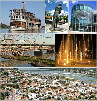
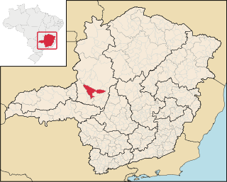
Pirapora is a municipality in northcentral Minas Gerais in Brazil. The population is 56,640 in an area of 550 km². The name Pirapora comes from the Tupi words for "fish" + "jump", referring to the piracema season when a mass migration of fishes ascends the São Francisco River to spawn.

<span class="mw-page-title-main">Boa Esperança, Espírito Santo</span> Municipality in Southeast, Brazil

Boa Esperança is a municipality located in the Brazilian state of Espírito Santo. Its population was 15,092 (2020) and its area is 429 km². Its average altitude is 140 meters above sea level.

<span class="mw-page-title-main">São Mateus, Espírito Santo</span> Municipality in Southeast, Brazil

São Mateus is a municipality located in the Brazilian state of Espírito Santo. Its population was estimated at 132,642 in 2020, and its area is 2,346 km². São Mateus is located at 36 meters above sea level.

<span class="mw-page-title-main">Patos de Minas</span> Municipality in Southeast, Brazil

Patos de Minas is a municipality in the state of Minas Gerais in Brazil.

<span class="mw-page-title-main">Sobral, Ceará</span> Municipality in Northeast, Brazil

Sobral is a municipality in the state of Ceará, Brazil.

<span class="mw-page-title-main">Arinos</span> Place in Minas Gerais, Brazil

Arinos is a municipality in northern Minas Gerais state in Brazil. Arinos is located east of the Federal District on the Urucuia River, a major tributary of the São Francisco. The city is 333 km from Brasília.

<span class="mw-page-title-main">Alagoinhas</span> Place in Nordeste, Brazil

Alagoinhas is a city in the Brazilian state of Bahia. It is located at around 12°8′9″S38°25′8″W. It was founded in 1852. In 1974, the city was made the seat of the Roman Catholic Diocese of Alagoinhas.

<span class="mw-page-title-main">Iguaba Grande</span> Municipality in Southeast, Brazil

Iguaba Grande is a municipality located in the Brazilian state of Rio de Janeiro. Its population was 28,837 (2020) and its area is 54 km².

<span class="mw-page-title-main">Santa Vitória do Palmar</span> City in South, Brazil

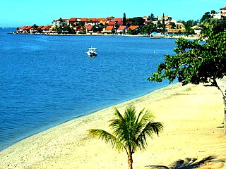
Santa Vitória do Palmar is a Brazilian city and municipality. It is the southernmost municipality in Brazil, located in the state of Rio Grande do Sul. To the west of the municipality is the Lagoa Mirim and beyond that is Uruguay; to the east and southeast lies the Atlantic Ocean, and to the north is the city of Rio Grande. To the south, it borders the municipality of Chuí and Uruguay.

<span class="mw-page-title-main">Climate of Brazil</span> Overview of the climate of Brazil

The climate in Brazil varies considerably from mostly tropical north to temperate zones south of the Tropic of Capricorn.

<span class="mw-page-title-main">Conceição do Mato Dentro</span> Place in Southeast, Brazil

Conceição do Mato Dentro is a Brazilian municipality located in the state of Minas Gerais. The city belongs to the mesoregion Metropolitana de Belo Horizonte and to the microregion of Conceição do Mato Dentro.

<span class="mw-page-title-main">Bom Jesus, Rio Grande do Sul</span> Municipality in Rio Grande do Sul, Brazil

Bom Jesus is a municipality in the state of Rio Grande do Sul, Brazil. Its population was approximately 11,309 in 2020.

<span class="mw-page-title-main">Encruzilhada do Sul</span> Municipality in Rio Grande do Sul, Brazil

Encruzilhada do Sul is a municipality in the state of Rio Grande do Sul, Brazil.

<span class="mw-page-title-main">Juramento</span> Municipality in the north of the Brazilian state of Minas Gerais

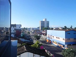
Juramento is a municipality in the north of the Brazilian state of Minas Gerais. As of 2020 the population was 4,345 in a total area of 432 km2. It became a municipality in 1953.

<span class="mw-page-title-main">São Joaquim</span> Municipality in South, Brazil

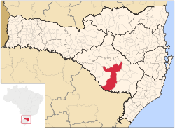
São Joaquim is a municipality in the state of Santa Catarina, situated in southern Brazil. Its population in 2020 was 27,139 inhabitants. Located in the Planalto Serrano, it lies 136 km from Tubarão, 81 km from Lages and 227 km from Florianópolis. The town is home to a variety of ethnic groups, including Italian, German, Portuguese, Japanese and Afro-Brazilians. There are also many people from other states in Brazil, especially from Rio Grande do Sul.

<span class="mw-page-title-main">Cametá</span> Place in Norte, Brazil

Cametá is a Brazilian municipality in the state of Pará.

<span class="mw-page-title-main">Floriano, Piauí</span> Municipality in Northeast, Brazil

Floriano is a Brazilian municipality in the state of Piauí. It was founded by the Arabs and Syrians. It is situated in the physiographic zone of the Médio Parnaíba, on the right side of the Parnaíba River, in front of the city of Barão de Grajaú, in the Maranhão. It is also intersected by the rivers Gurguéia and Itaueira.

Barra do Corda is a municipality in the state of Maranhão in the Northeast region of Brazil.

<span class="mw-page-title-main">Monte Alegre, Pará</span> Municipality in Northern, Brazil

Monte Alegre, Pará is a municipality in the state of Pará in the Northern region of Brazil. It is located along the Amazon River in northern Brazil.

<span class="mw-page-title-main">Taguatinga, Tocantins</span> Municipality in North Region, Brazil

Taguatinga is a municipality in the state of Tocantins in Brazil.

References

  1. "Population". Instituto Brasileiro de Geografia e Estatística. Retrieved 16 February 2024.
  2. "Ranking - Índice de Desenvolvimento Humano Municipal - 2010" (PDF). United Nations Development Programme (UNDP). Archived from the original (PDF) on July 8, 2014. Retrieved August 1, 2013.
  3. 1 2 "BDMEP - série histórica - dados diários - temperatura mínima (°C) - Lages". Instituto Nacional de Meteorologia. Retrieved 17 July 2015.
  4. 1 2 "BDMEP - série histórica - dados diários - temperatura máxima (°C) - Lages". Instituto Nacional de Meteorologia. Retrieved 17 July 2015.
  5. "BDMEP - série histórica - dados diários - precipitação (mm) - Lages". Instituto Nacional de Meteorologia. Retrieved 17 July 2015.
  6. "BDMEP - série histórica - dados mensais - precipitação total (mm) - Lages". Instituto Nacional de Meteorologia. Retrieved 2 May 2014.
  7. "BDMEP - série histórica - dados horários - umidade relativa (%) - Lages". Instituto Nacional de Meteorologia. Retrieved 17 July 2015.
  8. "Temperatura Máxima Mensal e Anual (°C)". Normais Climatológicas do Brasil 1991-2020 (in Portuguese). Instituto Nacional de Meteorologia. Archived from the original on 24 March 2022. Retrieved 20 May 2024.
  9. "Temperatura Média Compensada Mensal e Anual (°C)". Normais Climatológicas do Brasil 1991-2020 (in Portuguese). Instituto Nacional de Meteorologia. Archived from the original on 24 March 2022. Retrieved 20 May 2024.
  10. "Temperatura Mínima Mensal e Anual (°C)". Normais Climatológicas do Brasil 1991-2020 (in Portuguese). Instituto Nacional de Meteorologia. Archived from the original on 24 March 2022. Retrieved 20 May 2024.
  11. "Precipitação Acumulada Mensal e Anual (mm)". Normais Climatológicas do Brasil 1991-2020 (in Portuguese). Instituto Nacional de Meteorologia. Archived from the original on 24 March 2022. Retrieved 20 May 2024.
  12. "Número de dias no mês ou no ano com precipitação maior ou igual a (1 mm) (dias)". Normais Climatológicas do Brasil 1991-2020 (in Portuguese). Instituto Nacional de Meteorologia. Archived from the original on 24 March 2022. Retrieved 20 May 2024.
  13. "Umidade Relativa do Ar Compensada Mensal e Anual (%)". Normais Climatológicas do Brasil 1991-2020 (in Portuguese). Instituto Nacional de Meteorologia. Archived from the original on 24 March 2022. Retrieved 20 May 2024.
  14. "Insolação Total (horas)". Normais Climatológicas do Brasil 1991-2020 (in Portuguese). Instituto Nacional de Meteorologia. Archived from the original on 24 March 2022. Retrieved 20 May 2024.
  15. "Normais Climatológicas do Brasil". Instituto Nacional de Meteorologia. Retrieved 13 May 2018.
  16. "Bairros da cidade Lages". Guia Mais. Archived from the original on 20 February 2017.
  17. "Araucária, Lages". City Facts. Archived from the original on 29 October 2021.
  18. "Boqueirão, Lages". City Facts. Archived from the original on 29 October 2021.
  19. "Dom Daniel, Lages". City Facts. Archived from the original on 29 October 2021.
  20. "Frei Rogério, Lages". City Facts. Archived from the original on 7 November 2021.
  21. "Ponte Grande, Lages". City Facts. Archived from the original on 29 October 2021.
  22. "Pte. Grande". Google maps.
  23. "Santa Mônica, Lages". City Facts. Archived from the original on 3 November 2021.
  24. "Vista Alegre, Lages". City Facts. Archived from the original on 3 November 2021.