Google proves that this exists, but it does not provide anything that suggests this is notable by our standards.(proposed by Drmies )
If you can address this concern by improving, copyediting, sourcing, renaming, or merging the page, please edit this page and do so. You may remove this message if you improve the article or otherwise object to deletion for any reason. Although not required, you are encouraged to explain why you object to the deletion, either in your edit summary or on the talk page. If this template is removed, do not replace it.
The article may be deleted if this message remains in place for seven days, i.e., after 23:44, 5 November 2023 (UTC).
Expired [[WP:PROD|prod]], concern was: Google proves that this exists, but it does not provide anything that suggests this is notable by our standards.
Currently, GpsDrive uses raster images of maps, but plans for its development include the utilization of vector data from projects such as OpenStreetMap. Speech output is supported if Festival software is running. GpsDrive is designed to work with all Garmin GPS receivers having a serial port, as well as other GPS receivers with NMEA protocol support.
The Global Positioning System (GPS), originally Navstar GPS, is a satellite-based radio navigation system owned by the United States government and operated by the United States Space Force. It is one of the global navigation satellite systems (GNSS) that provide geolocation and time information to a GPS receiver anywhere on or near the Earth where there is an unobstructed line of sight to four or more GPS satellites. It does not require the user to transmit any data, and operates independently of any telephonic or Internet reception, though these technologies can enhance the usefulness of the GPS positioning information. It provides critical positioning capabilities to military, civil, and commercial users around the world. Although the United States government created, controls and maintains the GPS system, it is freely accessible to anyone with a GPS receiver.
A waypoint is an intermediate point or place on a route or line of travel, a stopping point or point at which course is changed, the first use of the term tracing to 1880. In modern terms, it most often refers to coordinates which specify one's position on the globe at the end of each "leg" (stage) of an air flight or sea passage, the generation and checking of which are generally done computationally.
NMEA 0183 is a combined electrical and data specification for communication between marine electronics such as echo sounder, sonars, anemometer, gyrocompass, autopilot, GPS receivers and many other types of instruments. It has been defined and is controlled by the National Marine Electronics Association (NMEA). It replaces the earlier NMEA 0180 and NMEA 0182 standards. In leisure marine applications it is slowly being phased out in favor of the newer NMEA 2000 standard, though NMEA 0183 remains the norm in commercial shipping.
Wardriving is the act of searching for Wi-Fi wireless networks, usually from a moving vehicle, using a laptop or smartphone. Software for wardriving is freely available on the internet.
GPX, or GPS Exchange Format, is an XML schema designed as a common GPS data format for software applications. It can be used to describe waypoints, tracks, and routes. It is an open format and can be used without the need to pay license fees. Location data is stored in tags and can be interchanged between GPS devices and software. Common software applications for the data include viewing tracks projected onto various map sources, annotating maps, and geotagging photographs based on the time they were taken.
The automatic identification system (AIS) is an automatic tracking system that uses transceivers on ships and is used by vessel traffic services (VTS). When satellites are used to receive AIS signatures, the term Satellite-AIS (S-AIS) is used. AIS information supplements marine radar, which continues to be the primary method of collision avoidance for water transport. Although technically and operationally distinct, the ADS-B system is analogous to AIS and performs a similar function for aircraft.
KisMAC is a wireless network discovery tool for Mac OS X. It has a wide range of features, similar to those of Kismet. The program is geared toward network security professionals, and is not as novice-friendly as similar applications. Distributed under the GNU General Public License, KisMAC is free software.
Microsoft Streets & Trips, known in other countries as Microsoft AutoRoute, is a discontinued mapping program developed and distributed by Microsoft. Functionally, the last version is a subset of Microsoft MapPoint targeted at the average consumer to do a variety of map related tasks in the North American region including the United States, Canada, and Mexico, such as route planning.
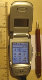
The Motorola A780 is the second cellular PDA running the Linux operating system.
Since the Global Positioning System (GPS) was introduced in the late 1980s there have been many attempts to integrate it into a navigation-assistance system for blind and visually impaired people.
A pulse per second is an electrical signal that has a width of less than one second and a sharply rising or abruptly falling edge that accurately repeats once per second. PPS signals are output by radio beacons, frequency standards, other types of precision oscillators and some GPS receivers. Precision clocks are sometimes manufactured by interfacing a PPS signal generator to processing equipment that aligns the PPS signal to the UTC second and converts it to a useful display. Atomic clocks usually have an external PPS output, although internally they may operate at 9,192,631,770 Hz. PPS signals have an accuracy ranging from a 12 picoseconds to a few microseconds per second, or 2.0 nanoseconds to a few milliseconds per day based on the resolution and accuracy of the device generating the signal.
gpsd is a computer software program that collects data from a Global Positioning System (GPS) receiver and provides the data via an Internet Protocol (IP) network to potentially multiple client applications in a server-client application architecture. Gpsd may be run as a daemon to operate transparently as a background task of the server. The network interface provides a standardized data format for multiple concurrent client applications, such as Kismet or GPS navigation software.
Satellite navigation software or GNSS navigation software usually falls into one of the following two categories:
Navigation with route calculation and directions from the software to the user of the route to take, based on a vector-based map, normally for motorized vehicles with some motorized forms added on as an afterthought.
Navigation tracking, often with a map "picture" in the background, but showing where you have been, and allowing "routes" to be preprogrammed, giving a line you can follow on the screen. This type can also be used for geocaching.
A satellite navigation device, satnav device or satellite navigation receiver is a user equipment that uses one or more of several global navigation satellite systems (GNSS) to calculate the device's geographical position and provide navigational advice. Depending on the software used, the satnav device may display the position on a map, as geographic coordinates, or may offer routing directions.
Computer cartography is the art, science, and technology of making and using maps with a computer. This technology represents a paradigm shift in how maps are produced, but is still fundamentally a subset of traditional cartography. The primary function of this technology is to produce maps, including creation of accurate representations of a particular area such as, detailing major road arteries and other points of interest for navigation, and in the creation of thematic maps. Computer cartography is one of the main functions of geographic information systems (GIS), however, GIS is not necessary to facilitate computer cartography and has functions beyond just making maps. The first peer-reviewed publications on using computers to help in the cartographic process predate the introduction of full GIS by several years.
The Ricoh 500SE digital compact camera is suitable for outdoor photography and networkability. Capability includes external information such as GPS position or barcode numbers within the image headers. External vendors sell hardware and software for workflows involving GPS positioning or barcode scanning. Most NMEA compliant bluetooth GPS receivers can be used with this camera through its built in bluetooth communication capability. The body is resistant to dust and water, making it robust for many environments.
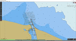
OpenSeaMap is a software project collecting freely usable nautical information and geospatial data to create a worldwide nautical chart. This chart is available on the OpenSeaMap website, and can also be downloaded for use as an electronic chart for offline applications.
A software GNSS receiver is a Global Navigation Satellite System (GNSS) receiver that has been designed and implemented using software-defined radio.
OpenCPN is a free software maritime chart plotter and navigation software for use underway or as a planning tool. Developed by a team of active sailors and tested in real world conditions, it has multiple supported chart formats and a variety of data inputs.
This article contains a list with gratis satellite navigation software for a range of devices. Some of the free software mentioned here does not have detailed maps or the ability to follow streets or type in street names. However, in many cases, it is also that which makes the program free, avoid the need of an Internet connection, and make it very lightweight. Very basic programs like this may not be suitable for road navigation in cars, but serve their purpose for navigation while walking or trekking, and for use at sea. To determine the GPS coordinates of a destination, one can use sites such as GPScoordinates.eu and GPS visualizer.
This page is based on this Wikipedia article Text is available under the CC BY-SA 4.0 license; additional terms may apply. Images, videos and audio are available under their respective licenses.