
Drainage is the natural or artificial removal of a surface's water and sub-surface water from an area with excess water. The internal drainage of most agricultural soils can prevent severe waterlogging, but many soils need artificial drainage to improve production or to manage water supplies.

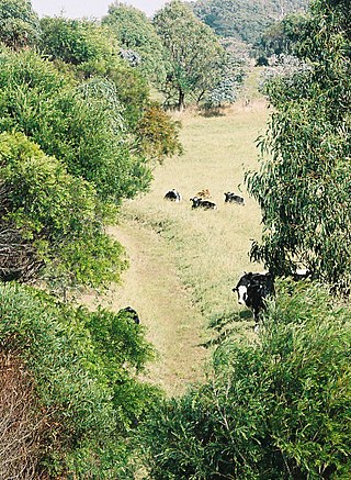
A gully is a landform created by running water, mass movement, or commonly a combination of both eroding sharply into soil or other relatively erodible material, typically on a hillside or in river floodplains or terraces. Gullies resemble large ditches or small valleys, but are metres to tens of metres in depth and width, are characterized by a distinct 'headscarp' or 'headwall' and progress by headward erosion. Gullies are commonly related to intermittent or ephemeral water flow, usually associated with localised intense or protracted rainfall events or snowmelt. Gullies can be formed and accelerated by cultivation practices on hillslopes in farmland, and they can develop rapidly in rangelands from existing natural erosion forms subject to vegetative cover removal and livestock activity.

Permeable paving surfaces are made of either a porous material that enables stormwater to flow through it or nonporous blocks spaced so that water can flow between the gaps. Permeable paving can also include a variety of surfacing techniques for roads, parking lots, and pedestrian walkways. Permeable pavement surfaces may be composed of; pervious concrete, porous asphalt, paving stones, or interlocking pavers. Unlike traditional impervious paving materials such as concrete and asphalt, permeable paving systems allow stormwater to percolate and infiltrate through the pavement and into the aggregate layers and/or soil below. In addition to reducing surface runoff, permeable paving systems can trap suspended solids, thereby filtering pollutants from stormwater.

Terrain or relief involves the vertical and horizontal dimensions of land surface. The term bathymetry is used to describe underwater relief, while hypsometry studies terrain relative to sea level. The Latin word terra means "earth."

A French drain is a trench filled with gravel or rock, or both, with or without a perforated pipe that redirects surface water and groundwater away from an area. The perforated pipe is called a weeping tile. When the pipe is draining, it "weeps", or exudes liquids. It was named during a time period when drainpipes were made from terracotta tiles.

A berm is a level space, shelf, or raised barrier separating areas in a vertical way, especially partway up a long slope. It can serve as a terrace road, track, path, a fortification line, a border/separation barrier for navigation, good drainage, industry, or other purposes.

Earthworks are engineering works created through the processing of parts of the earth's surface involving quantities of soil or unformed rock.

Soil conservation is the prevention of loss of the topmost layer of the soil from erosion or prevention of reduced fertility caused by over usage, acidification, salinization or other chemical soil contamination.

In earthmoving, cut and fill is the process of constructing a railway, road or canal whereby the amount of material from cuts roughly matches the amount of fill needed to make nearby embankments to minimize the amount of construction labor.
Keyline design is a landscaping technique of maximizing the beneficial use of the water resources of a tract of land. The "keyline" is a specific topographic feature related to the natural flow of water on the tract. Keyline design is a system of principles and techniques of developing rural and urban landscapes to optimize use of their water resources.

A gravel road is a type of unpaved road surfaced with gravel that has been brought to the site from a quarry or stream bed. Gravel roads are common in less-developed nations, and also in the rural areas of developed nations such as Canada and the United States. In New Zealand, and other Commonwealth countries, they may be known as metal roads. They may be referred to as "dirt roads" in common speech, but that term is used more for unimproved roads with no surface material added. If well constructed and maintained, a gravel road is an all-weather road.
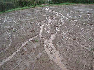
In hillslope geomorphology, a rill is a shallow channel cut into soil by the erosive action of flowing surface water. Similar but smaller incised channels are known as microrills; larger incised channels are known as gullies.

Surface runoff is the unconfined flow of water over the ground surface, in contrast to channel runoff. It occurs when excess rainwater, stormwater, meltwater, or other sources, can no longer sufficiently rapidly infiltrate in the soil. This can occur when the soil is saturated by water to its full capacity, and the rain arrives more quickly than the soil can absorb it. Surface runoff often occurs because impervious areas do not allow water to soak into the ground. Furthermore, runoff can occur either through natural or human-made processes.
Landslide mitigation refers to several human-made activities on slopes with the goal of lessening the effect of landslides. Landslides can be triggered by many, sometimes concomitant causes. In addition to shallow erosion or reduction of shear strength caused by seasonal rainfall, landslides may be triggered by anthropic activities, such as adding excessive weight above the slope, digging at mid-slope or at the foot of the slope. Often, individual phenomena join to generate instability over time, which often does not allow a reconstruction of the evolution of a particular landslide. Therefore, landslide hazard mitigation measures are not generally classified according to the phenomenon that might cause a landslide. Instead, they are classified by the sort of slope stabilization method used:

A buffer strip is an area of land maintained in permanent vegetation that helps to control air quality, soil quality, and water quality, along with other environmental problems, dealing primarily on land that is used in agriculture. Buffer strips trap sediment, and enhance filtration of nutrients and pesticides by slowing down surface runoff that could enter the local surface waters. The root systems of the planted vegetation in these buffers hold soil particles together which alleviate the soil of wind erosion and stabilize stream banks providing protection against substantial erosion and landslides. Farmers can also use buffer strips to square up existing crop fields to provide safety for equipment while also farming more efficiently.
The topography of central Seattle was radically altered by a series of regrades in the city's first century of urban settlement, in what might have been the largest such alteration of urban terrain at the time.

Surface irrigation is where water is applied and distributed over the soil surface by gravity. It is by far the most common form of irrigation throughout the world and has been practiced in many areas virtually unchanged for thousands of years.
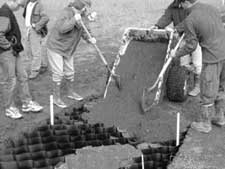
Cellular confinement systems (CCS)—also known as geocells—are widely used in construction for erosion control, soil stabilization on flat ground and steep slopes, channel protection, and structural reinforcement for load support and earth retention. Typical cellular confinement systems are geosynthetics made with ultrasonically welded high-density polyethylene (HDPE) strips or novel polymeric alloy (NPA)—and expanded on-site to form a honeycomb-like structure—and filled with sand, soil, rock, gravel or concrete.

A check dam is a small, sometimes temporary, dam constructed across a swale, drainage ditch, or waterway to counteract erosion by reducing water flow velocity. Check dams themselves are not a type of new technology; rather, they are an ancient technique dating from the second century AD. Check dams are typically, though not always, implemented in a system of several dams situated at regular intervals across the area of interest.

A level spreader is an erosion control device designed to reduce water pollution by mitigating the impact of high-velocity stormwater surface runoff. It is used both on construction sites and for permanent applications such as drainage for roads and highways. The device reduces the energy level in high-velocity flow by converting it into sheet flow, and disperses the discharged water so that it may be infiltrated into soil.


