Hakatai Shale

Last updated
Hakatai Shale
Stratigraphic range:
Meso-Proterozoic,
1,200±50 Ma?
Grand Canyon with Snow 4.JPG
Three approximate equal-thickness formations outcropping below Isis Temple-prominence at north perimeter, Granite Gorge
(Unkar Group)–Shinumo Quartzite (vertical cliffs), upon basalt sills, upon orange-red Hakatai Shale, upon Bass Formation.
Dk blackish canyons are the Granite Gorge Vishnu Basement Rocks.
Type Geological formation
Unit of Unkar Group (5 units)
Underlies Shinumo Quartzite – (unit 3)
Overlies Bass Formation – (unit 1)
Thickness985 feet (300 m) approximate maximum
Lithology
Primary shale
Other siltstone, sandy siltstone, and sandstone (subarkose, arkose and quartz arenite)
Location
Region Arizona, Grand Canyon
Isis Temple region, southwest Bright Angel Canyon, at north side, Granite Gorge, and along Colorado River, also,
numerous side canyons to Granite Gorge / Colorado River
Country United States
(Southwest United States)
Type section
Named forHakatai Canyon
Named byNoble (1914) [1]
Basalt dike in orange-red Hakatai Shale along Colorado River at Hance Rapid, river mile 76.5, Grand Canyon. Grand Canyon Supergroup Hakatai Shale with Basalt Dike.jpg
Basalt dike in orange-red Hakatai Shale along Colorado River at Hance Rapid, river mile 76.5, Grand Canyon.
Many layers of rock. Tonto Group and Unkar units. Shows the Vishnu rocks; but also the orange Hakatai Shale, Shinumo Quartzite, some Bass Formation?, etc. The upper massive layers show the white cliffs of Coconino Sandstone over the Supai Group redbeds that sit upon the Redwall Limestone. El canon grandioso, 9-15 (30597718082).jpg
Many layers of rock. Tonto Group and Unkar units. Shows the Vishnu rocks; but also the orange Hakatai Shale, Shinumo Quartzite, some Bass Formation?, etc. The upper massive layers show the white cliffs of Coconino Sandstone over the Supai Group redbeds that sit upon the Redwall Limestone.
Geologic stratigraphic column of strata exposed in and near the Grand Canyon showing stratigraphic units and major unconformities 2021 Revised USGS Geologic Stratigraphic Column of the Grand Canyon.jpg
Geologic stratigraphic column of strata exposed in and near the Grand Canyon showing stratigraphic units and major unconformities

The Hakatai Shale is a Mesoproterozoic rock formation with important exposures in the Grand Canyon, Coconino County, Arizona. It consists of colorful strata that exhibit colors varying from purple to red to brilliant orange. These colors are the result of the oxidation of iron-bearing minerals in the Hakatai Shale. It consists of lower and middle members that consist of bright-red, slope-forming, highly fractured, argillaceous mudstones and shale and an upper member composed of purple and red, cliff-forming, medium-grained sandstone. Its thickness, which apparently increases eastwards, varies from 137 to 300 m (449 to 984 ft). In general, the Hakatai Shale and associated strata of the Unkar Group rocks dip northeast (10–30°) toward normal faults that dip 60° or more toward the southwest. This can be seen at the Palisades fault in the eastern part of the main Unkar Group outcrop area (below East Rim). In addition, thick, prominent, and dark-colored basaltic sills and dikes cut across the purple to red to brilliant orange strata of the Hakatai Shale. [2] [3] [4]

Contents

The bright orange-red slopes of the Hakatai Shale contrasts sharply against the grayish outcrops of the Bass Formation. The outcrop of the Hakatai Shale also contrasts greatly with the steep cliffs formed by Shinumo Quartzite as seen at the base of Isis Temple. In the central Grand Canyon north of Grand Canyon Village and viewed from the south at the South Rim, the bright orange-red unit can be seen below the Isis Temple and Cheops Pyramid landforms at the intersection of Bright Angel Canyon and Granite Gorge; the Bright Angel Trail from the South Rim traverses through the geographic region to the north, the North Kaibab Trail in Bright Angel Canyon. [2] [4]

The Hakatai Shale is part of a conformable sequence of sedimentary strata that comprise the Unkar Group. The Unkar Group is about 1,600 to 2,200 m (5,200 to 7,200 ft) thick and composed, in ascending order, of the Bass Formation, Hakatai Shale, Shinumo Quartzite, Dox Formation, and Cardenas Basalt. In ascending order, the Unkar Group is overlain by the Nankoweap Formation, about 113 to 150 m (371 to 492 ft) thick; the Chuar Group, about 1,900 m (6,200 ft) thick; and the Sixtymile Formation, about 60 m (200 ft) thick. The Grand Canyon Supergroup, of which the Unkar Group is the lowermost part, overlies deeply eroded granites, gneisses, pegmatites, and schists that comprise Vishnu Basement Rocks. [2] [5] [6]

Description

~closeup of bedding in Hakatai Shale
(view downstream, ~west/northwest from Grandview Point, near East Rim, Grand Canyon) Desert View Grandview 3 (15358762918).jpg
~closeup of bedding in Hakatai Shale
(view downstream, ~west/northwest from Grandview Point, near East Rim, Grand Canyon)

Typically, the Hakatai Shale is subdivided into three informal members. In ascending order they are the Hance Rapids (lower), Cheops Pyramid (middle), and Stone Creek (upper) members. The total thickness of the Hakatai Shale varies from 135 m (443 ft) at Hance Rapids to nearly 300 m (980 ft) at the type section in Hakatai Canyon in the Shinumo Creek area. [2] [7]

First, the Hance Rapids (lower) member consists of purple to reddish-purple mudstone, interbedded sandy siltstone, and rare occurrences of thin-bedded subarkose- to quartz arenite. Beds of the lower member of the Hakatai Shale grade upward into the fine-grained middle member, with a boundary drawn at or very near their color change. Second, the Cheops Pyramid (middle) member consists of mudstone, siltstone, and subordinate sandy siltstone that exhibit a striking reddish-orange color. These distinctively red-colored strata are commonly mottled with small to large (up to 10 cm and more across), non-red, spherical to spheroidal reduction spots. These mottles have dark-gray to greenish-gray central nuclei that contain very dark gray to black central cores. Finally, the Stone Creek (upper) member of the Hakatai Shale consists of pale purple or lavender, fine- to coarse-grained, crossbedded coarse arkose. [7] [8] [9]

Basaltic sills and dikes intrude all of the Unkar Group below the Cardenas Basalt. Sills intruded only the Bass Formation and Hakatai Shale. Dikes intrude the Hakatai Shale, Shinumo Quartzite, and Dox Formation. The sills range in thickness from 23 m (75 ft) at Hance Rapids, eastern Grand Canyon, to 300 m (980 ft) in Hakatai Canyon in the Shinumo Creek area. The feeder dikes to these sills are not exposed. However, the feeder dikes for the Cardenas Basalt can be traced, discontinuously, to within a few meters of its base. Adjacent to the sills, the Hatakai Shale has been altered to knotted hornfels containing porphyroblasts of andalusite and cordierite that have been replaced by muscovite and green chlorite, respectively. [2]

Contacts

In the eastern part of the Grand Canyon, the contact between the Hatakai Shale with underlying Bass Formation is typically gradational over an interval of a meter or so. For example, in Red Canyon, the contact consists of an interval in which stromatolitic limestone of the Bass Formation is intimately interbedded with coarse deposits of the overlying Hakatai Shale. In the eastern part of the Grand Canyon, the contact is sharp, but conformable. [2] [10]

The contact between the Hatakai Shale and the overlying Shinumo Quartzite is a distinct, significant disconformity. This disconformity is sharp and locally truncates cross-beds, and channel forms, within the sandstones of the underlying Hatakai Shale. Within the lower subarkose of the Shinumo Sandstone, a basal lag of conglomerate, which contains basement clasts up to 5 cm (2.0 in) across, lies on the eroded surface that forms this disconformity. This basal conglomerate contains quartzite clasts that lack any known equivalents in the Grand Canyon region. As documented by the dating of detrital zircons, this disconformity is estimated to represent a period of about 75 million years. [2] [7]

The contact between the Tapeats Sandstone and Hatakai Shale and the rest of the folded and faulted Unkar Group is a prominent angular unconformity, which is part of the Great Unconformity. The differential erosion of the Unkar Group left resistant beds of the Cardenas Basalt and Shinumo Quartzite as topographic highs, ancient monadnocks, that are now buried by sandstones, shales, and conglomerates of the Tapeats Sandstone. These monadnocks served locally as sources of coarse-grained sediments during the marine transgression that deposited the Tapeats Sandstone and other members of the Tonto Group. The contact between the Hatakai Shale and the Tapeats Sandstone forms part of a relatively flat surface that lies between the monadnocks. [2]

Fossils

Stromatolites have been found within spectacular exposures of the Hatakai Shale in Rodgers Canyon. At this outcrop, they occur in the transitional zone between it and the Bass Formation where stromatolitic carbonate beds are intimately interbedded with coarse deposits of the Hakatai Shale. The base of these deposits contains stromatolite onchaloids, small algal mounds, that are built upon coarse clasts of sandstone-conglomerate. [10] In addition, the dark gray to black central cores of the reduction mottles found in the Cheops Pyramid (middle) member is possible of organic (stromatolitic?) origin. [7]

A number of spurious and discredited reports about other types of fossils found in the Hatakai Shale have been made. In one case, apparent trails of metazoans were reported from the Hatakai Shale. [11] However, these reported trace fossils are now regarded to be nonbiogenic pseudofossils. [12]

Depositional environments

The strata comprising the Hance Rapids (lower) member is interpreted to have accumulated beneath shallow, low-energy waters. The change from Bass Formation to the lower member likely represent the waning stages of marine deposition during which the Bass Formation accumulated. The Cheops Pyramid (middle) member is regarded to have accumulated either in a shallow, near-shore marine environment or in coastal plain mudflats, or deltas. The greenish gray reduction mottles are similar in nature to reduction mottles observed in the lower middle and upper members of the Dox Formation, which are regarded as having accumulated in nonmarine environments. The Stone Creek (upper) member is of probable marine deltaic origin. [2] [8] [9]

Age

The Hatakai Shale is between 1,253 and 1,104 million years old. It is younger than a layer of volcanic ash in the underlying Bass Formation that has been dated at 1,253 million years. In addition, the 40Ar/39Ar dating of detrital muscovite from the basal, Escalante Creek Member of the overlying Dox Formation indicates that it is younger than 1,140 million years. The overlying Dox Formation is older than the age of the Cardenas Basalt, which is 1,104 million years. [13] [14]

Isis Temple-Cheops Pyramid horst

Isis Temple-Cheops Pyramid is a small horst, located close to the geographic center of the Grand Canyon. It is bordered on the east by the Bright Angel Fault and on the south by Granite Gorge; the Bright Angel Fault continues to the south-southwest across Granite Gorge and up Garden Creek, up the Bright Angel Trail to the South Rim. The north side of Isis Temple-Cheops Pyramid is bordered by the approximate east-west, Grandview Fault.

See also

Related Research Articles

<span class="mw-page-title-main">Geology of the Grand Canyon area</span> Aspect of geology

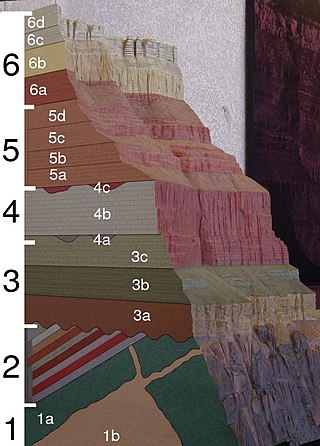
The geology of the Grand Canyon area includes one of the most complete and studied sequences of rock on Earth. The nearly 40 major sedimentary rock layers exposed in the Grand Canyon and in the Grand Canyon National Park area range in age from about 200 million to nearly 2 billion years old. Most were deposited in warm, shallow seas and near ancient, long-gone sea shores in western North America. Both marine and terrestrial sediments are represented, including lithified sand dunes from an extinct desert. There are at least 14 known unconformities in the geologic record found in the Grand Canyon.

<span class="mw-page-title-main">Great Unconformity</span> Gap in geological strata

Of the many unconformities (gaps) observed in geological strata, the term Great Unconformity is frequently applied to either the unconformity observed by James Hutton in 1787 at Siccar Point in Scotland, or that observed by John Wesley Powell in the Grand Canyon in 1869. Both instances are exceptional examples of where the contacts between sedimentary strata and either sedimentary or crystalline strata of greatly different ages, origins, and structure represent periods of geologic time sufficiently long to raise great mountains and then erode them away.

<span class="mw-page-title-main">Tonto Group</span> Cambrian geologic unit in the Grand Canyon region, Arizona

The Tonto Group is a name for an assemblage of related sedimentary strata, collectively known by geologists as a Group, that comprises the basal sequence Paleozoic strata exposed in the sides of the Grand Canyon. As currently defined, the Tonto groups consists of the Sixtymile Formation, Tapeats Sandstone, Bright Angel Shale, Muav Limestone, and Frenchman Mountain Dolostone. Historically, it included only the Tapeats Sandstone, Bright Angel Shale, and Muav Limestone. Because these units are defined by lithology and three of them interfinger and intergrade laterally, they lack the simple layer cake geology as they are typically portrayed as having and geological mapping of them is complicated.

<span class="mw-page-title-main">Muav Limestone</span> Cambrian geologic formation found in the Southwestern United States

The Muav Limestone is a Cambrian geologic formation within the 5-member Tonto Group. It is a thin-bedded, gray, medium to fine-grained, mottled dolomite; coarse- to medium-grained, grayish-white, sandy dolomite and grayish-white, mottled, fine-grained limestone. It also contains beds of shale and intraformational conglomerate. The beds of the Muav Limestone are either structureless or exhibit horizontally laminations and cross-stratification. The Muav Limestone forms cliffs or small ledges that weather a dark gray or rusty-orange color. These cliffs or small ledges directly overlie the sloping surfaces of the Bright Angel Shale. The thickness of this formation decreases eastward from 250 feet (76 m) in the western Grand Canyon to 45 feet (14 m) in the eastern Grand Canyon. To the west in southern Nevada, its thickness increases to 830 feet (250 m) in the Frenchman Mountain region.

<span class="mw-page-title-main">Tapeats Sandstone</span> Cambrian geologic formation found in the Southwestern United States

Except where underlain by the Sixtymile Formation, the Tapeats Sandstone is the Cambrian geologic formation that is the basal geologic unit of the Tonto Group. Typically, it is also the basal geologic formation of the Phanerozoic strata exposed in the Grand Canyon, Arizona, and parts of northern Arizona, central Arizona, southeast California, southern Nevada, and southeast Utah. The Tapeats Sandstone is about 230 feet (70 m) thick, at its maximum. The lower and middle sandstone beds of the Tapeats Sandstone are well-cemented, resistant to erosion, and form brownish, vertical cliffs that rise above the underlying Precambrian strata outcropping within Granite Gorge. They form the edge of the Tonto Platform. The upper beds of the Tapeats Sandstone form the surface of the Tonto Platform. The overlying soft shales and siltstones of the Bright Angel Shale underlie drab-greenish slopes that rise from the Tonto Platform to cliffs formed by limestones of the Muav Limestone and dolomites of the Frenchman Mountain Dolostone.

<span class="mw-page-title-main">Cardenas Basalt</span> Rock formation in the Grand Canyon, Arizona

The Cardenas Basalt, also known as either the Cardenas Lava or Cardenas Lavas, is a rock formation that outcrops over an area of about 310 km2 (120 mi2) in the eastern Grand Canyon, Coconino County, Arizona. The lower part of the Cardenas Basalt forms granular talus slopes. Its upper part forms nearly continuous low cliffs that are parallel to the general course of the Colorado River. The most complete, readily accessible, and easily studied exposure of the Cardenas Basalt lies in Basalt Canyon. This is also its type locality.

<span class="mw-page-title-main">Unkar Group</span> Sequence of geologic strata of Proterozoic age

The Unkar Group is a sequence of strata of Proterozoic age that are subdivided into five geologic formations and exposed within the Grand Canyon, Arizona, Southwestern United States. The Unkar Group is the basal member of the 8-member Grand Canyon Supergroup. The Unkar is about 1,600 to 2,200 m thick and composed, in ascending order, of the Bass Formation, Hakatai Shale, Shinumo Quartzite, Dox Formation, and Cardenas Basalt. The Cardenas Basalt and Dox Formation are found mostly in the eastern region of Grand Canyon. The Shinumo Quartzite, Hakatai Shale, and Bass Formation are found in central Grand Canyon. The Unkar Group accumulated approximately between 1250 and 1104 Ma. In ascending order, the Unkar Group is overlain by the Nankoweap Formation, about 113 to 150 m thick; the Chuar Group, about 1,900 m (6,200 ft) thick; and the Sixtymile Formation, about 60 m (200 ft) thick. These are all of the units of the Grand Canyon Supergroup. The Unkar Group makes up approximately half of the thickness of the 8-unit Supergroup.

<span class="mw-page-title-main">Nankoweap Formation</span> Neoproterozoic geologic sequence of the Grand Canyon Supergroup

The Neoproterozoic Nankoweap Formation, is a thin sequence of distinctive red beds that consist of reddish brown and tan sandstones and subordinate siltstones and mudrocks that unconformably overlie basaltic lava flows of the Cardenas Basalt of the Unkar Group and underlie the sedimentary strata of the Galeros Formation of the Chuar Group. The Nankoweap Formation is slightly more than 100 m in thickness. It is informally subdivided into informal lower and upper members that are separated and enclosed by unconformities. Its lower (ferruginous) member is 0 to 15 m thick. The Grand Canyon Supergroup, of which the Nankoweap Formation is part, unconformably overlies deeply eroded granites, gneisses, pegmatites, and schists that comprise Vishnu Basement Rocks.

<span class="mw-page-title-main">Isis Temple</span> Landform in the Grand Canyon, Arizona

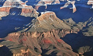
Isis Temple is a prominence in the Grand Canyon, Arizona, Southwestern United States. It is located below the North Rim and adjacent to the Granite Gorge along the Colorado River. The Trinity Creek and canyon flow due south at its west border; its north, and northeast border/flank is formed by Phantom Creek and canyon, a west tributary of Bright Angel Creek; the creeks intersect about 3 mi (4.8 km) southeast, and 1.0 mi (1.6 km) north of Granite Gorge. The Isis Temple prominence, is only about 202 ft (62 m) lower than Grand Canyon Village, the main public center on Grand Canyon’s South Rim.

<span class="mw-page-title-main">Grand Canyon Supergroup</span> Sequence of sedimentary strata

The Grand Canyon Supergroup is a Mesoproterozoic to a Neoproterozoic sequence of sedimentary strata, partially exposed in the eastern Grand Canyon of Arizona. This group comprises the Unkar Group, Nankoweap Formation, Chuar Group and the Sixtymile Formation, which overlie Vishnu Basement Rocks. Several notable landmarks of the Grand Canyon, such as the Isis Temple and Cheops Pyramid, and the Apollo Temple, are surface manifestations of the Grand Canyon Supergroup.

<span class="mw-page-title-main">Tanner Graben</span> Landform in the Grand Canyon, Arizona

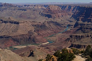
Located directly downstream of the Little Colorado River confluence with the Colorado River, the Tanner Graben, in the Grand Canyon, Arizona, US is a prominence and cliffside rock formation below the East Rim. Tanner Graben is located riverside, on the Colorado River, on a north-northwest bank at Mile 68.5, and lies opposite Tanner Canyon. The Tanner Rapid, created by Tanner Creek lies at the riverside foot of the graben. The graben is a pronounced feature because of the black Cardenas Basalt that forms the middle section of the graben, presumably free of debris accumulation by its cliff face steepness, and winds, and airflow drainage that course through the Colorado River's canyons; unprotected side canyons of Cardenas Basalt show accumulations as a slope-forming geologic unit, with little showing of black basalt.

<span class="mw-page-title-main">Bass Formation</span> Lithostratigraphic unit found in Arizona, US

The Bass Formation, also known as the Bass Limestone, is a Mesoproterozoic rock formation that outcrops in the eastern Grand Canyon, Coconino County, Arizona. The Bass Formation erodes as either cliffs or stair-stepped cliffs. In the case of the stair-stepped topography, resistant dolomite layers form risers and argillite layers form steep treads. In general, the Bass Formation in the Grand Canyon region and associated strata of the Unkar Group-rocks dip northeast (10°–30°) toward normal faults that dip 60+° toward the southwest. This can be seen at the Palisades fault in the eastern part of the main Unkar Group outcrop area. In addition, thick, prominent, and dark-colored basaltic sills intrude across the Bass Formation.

<span class="mw-page-title-main">Shinumo Quartzite</span> Mesoproterozoic rock formation in the Grand Canyon, Arizona

The Shinumo Quartzite also known as the Shinumo Sandstone, is a Mesoproterozoic rock formation, which outcrops in the eastern Grand Canyon, Coconino County, Arizona,. It is the 3rd member of the 5-unit Unkar Group. The Shinumo Quartzite consists of a series of massive, cliff-forming sandstones and sedimentary quartzites. Its cliffs contrast sharply with the stair-stepped topography of typically brightly-colored strata of the underlying slope-forming Hakatai Shale. Overlying the Shinumo, dark green to black, fissile, slope-forming shales of the Dox Formation create a well-defined notch. It and other formations of the Unkar Group occur as isolated fault-bound remnants along the main stem of the Colorado River and its tributaries in Grand Canyon.

Typically, the Shinumo Quartzite and associated strata of the Unkar Group dip northeast (10°–30°) toward normal faults that dip 60+° toward the southwest. This can be seen at the Palisades fault in the eastern part of the main Unkar Group outcrop area.

<span class="mw-page-title-main">Dox Formation</span> Landform in the Grand Canyon, Arizona

The Dox Formation, also known as the Dox Sandstone, is a Mesoproterozoic rock formation that outcrops in the eastern Grand Canyon, Coconino County, Arizona. The strata of the Dox Formation, except for some more resistant sandstone beds, are relatively susceptible to erosion and weathering. The lower member of the Dox Formation consists of silty-sandstone and sandstone, and some interbedded argillaceous beds, that form stair-stepped, cliff-slope topography. The bulk of the Dox Formation typically forms rounded and sloping hill topography that occupies an unusually broad section of the canyon.

<span class="mw-page-title-main">Vishnu Basement Rocks</span> Lithostratigraphic unit in the Grand Canyon, Arizona

The Vishnu Basement Rocks is the name recommended for all Early Proterozoic crystalline rocks exposed in the Grand Canyon region. They form the crystalline basement rocks that underlie the Bass Limestone of the Unkar Group of the Grand Canyon Supergroup and the Tapeats Sandstone of the Tonto Group. These basement rocks have also been called either the Vishnu Complex or Vishnu Metamorphic Complex. These Early Proterozoic crystalline rocks consist of metamorphic rocks that are collectively known as the Granite Gorge Metamorphic Suite; sections of the Vishnu Basement Rocks contain Early Paleoproterozoic granite, granitic pegmatite, aplite, and granodiorite that have intruded these metamorphic rocks, and also, intrusive Early Paleoproterozoic ultramafic rocks.

<span class="mw-page-title-main">Bright Angel Shale</span> Cambrian geologic formation found in the Southwestern United States

The Bright Angel Shale is one of five geological formations that comprise the Cambrian Tonto Group. It and the other formations of the Tonto Group outcrop in the Grand Canyon, Arizona, and parts of northern Arizona, central Arizona, southeast California, southern Nevada, and southeast Utah. The Bright Angel Shale consists of locally fossiliferous, green and red-brown, micaceous, fissile shale (mudstone) and siltstone with local, thicker beds of brown to tan sandstone and limestone. It ranges in thickness from 57 to 450 feet. Typically, its thin-bedded shales and sandstones are interbedded in cm-scale cycles. They also exhibit abundant sedimentary structures that include current, oscillation, and interference ripples. The Bright Angel Shale also gradually grades downward into the underlying Tapeats Sandstone. It also complexly interfingers with the overlying Muav Limestone. These characters make the upper and lower contacts of the Bright Angel Shale often difficult to define. Typically, its thin-bedded shales and sandstones erode into green and red-brown slopes that rise from the Tonto Platform up to cliffs formed by limestones of the overlying Muav Limestone and dolomites of the Frenchman Mountain Dolostone.

The Neoproterozoic Chuar Group consists of 5,250 feet (1,600 m) of fossiliferous, unmetamorphosed sedimentary strata that is composed of about 85% mudrock. The Group is the approximate upper half of the Grand Canyon Supergroup, overlain by the thin, in comparison, Sixtymile Formation, the top member of the multi-membered Grand Canyon Supergroup.

<span class="mw-page-title-main">Sixtymile Formation</span> Cambrian geologic formation found in Grand Canyon, Arizona

The Sixtymile Formation is a very thin accumulation of sandstone, siltstone, and breccia underlying the Tapeats Sandstone that is exposed in only four places in the Chuar Valley. These exposures occur atop Nankoweap Butte and within Awatubi and Sixtymile Canyons in the eastern Grand Canyon, Arizona. The maximum preserved thickness of the Sixtymile Formation is about 60 meters (200 ft). The actual depositional thickness of the Sixtymile Formation is unknown owing to erosion prior to deposition of the Tapeats Sandstone.

<span class="mw-page-title-main">Cheops Pyramid</span> Landform in the Grand Canyon, Arizona

Cheops Pyramid is a 5,401-foot-elevation (1,646-meter) summit located in the Grand Canyon, in Coconino County of Arizona, US.

<span class="mw-page-title-main">Ochoa Point</span> Landform in the Grand Canyon, Arizona

Ochoa Point is a 4,761-foot-elevation cliff-summit located in the eastern Grand Canyon, in Coconino County of northern Arizona, US. The landform is on a southeast ridgeline from Apollo Temple, with the Ochoa Point prominence on its southeast terminus. Ochoa Point is 1.0 mi from Apollo Temple, 1.5 mi northwest from the southeast-flowing Colorado River, and 3.5 miles due-west from the south terminus of the East Rim, Grand Canyon.

Ochoa Point’s southwest cliff-flank, and Apollo Temple’s southwest arm, contain the dp-black Basalt Cliffs ; the Cardenas Basalt lies upon brilliantly colored reddish Dox Formation low-angle, erosion-slopes of five Unkar Group members. What makes Ochoa Point distinctive, the next rock unit above is the colorful, layered (banded), Nankoweap Formation. These rock layers all slope at approximately 15 degrees, and are topped by the short-cliff, horizontal Tapeats Sandstone.

References

  1. Noble, LF (1914) The Shinumo Quadrangle, Grand Canyon District, Arizona. Bulletin. no. 549. US Geological Survey, Reston, Virginia. 100 pp.
  2. 1 2 3 4 5 6 7 8 9 Hendricks, JD, and GM Stevenson (2003) Grand Canyon Supergroup: Unkar Group. In SS Beus and M Morales, eds., pp. 39–52, Grand Canyon Geology, 2nd ed. Oxford University Press, New York.
  3. Billingsley, GH (2000) Geologic Map of the Grand Canyon 30 × 60 Quadrangle, Coconino and Mohave Counties, Northwestern Arizona, Pamphlet to accompany Geologic Investigations Series I–2688 Version 1.0.U.S. Geological Survey, Reston, Virginia. 15 pp.
  4. 1 2 Beus, SS, RR Rawson, RO Dalton, GM Stevenson, VS Reed, and TM Daneker (1974) Preliminary report on the Unkar Group (Precambrian) in Grand Canyon, Arizona. In TNV Karlstrom, GA Swann, and RL Eastwood, ed., pp. 34–53, Geology of northern Arizona, with notes on archaeology and paleoclimate; Part 1, Regional studies. Geological Society of America, Rocky Mountain Section, Boulder, Colorado. 407 pp.
  5. Elton, DP, and EH McKee (1982) Age and correlation of the late Proterozoic Grand Canyon disturbance, northern Arizona. Geological Society of America Bulletin. 93(8): 681–99.
  6. Karlstrom, KE, BR Ilg, Bradley, D Hawkins, ML Williams, G Dumond, KK. Mahan, and SA Bowring, Samuel (2012) Vishnu Basement Rocks of the Upper Granite Gorge: Continent formation 1.84 to 1.66 billion years ago. In JM Timmons and KE Karlstrom, eds., pp. 7–24, Grand Canyon geology: Two billion years of earth's history. Special Paper no 294, Geological Society of America, Boulder, Colorado.
  7. 1 2 3 4 Timmons, JM, KE Karlstrom, MT Heizler, SA Bowring, GE Gehrels, and LJ Crossey, (2005) Tectonic inferences from the ca. 1254–1100 Ma Unkar Group and Nankoweap Formation, Grand Canyon: Intracratonic deformation and basin formation during protracted Grenville orogenesis. Geological Society of America Bulletin. 117(11–12): 1573–95.
  8. 1 2 Reed VS (1976) Stratigraphy and depositional environment of the Hakatai Shale, Grand Canyon, Arizona. Unpublished Master's Thesis, Northern Arizona University, Flagstaff, Arizona. 163 pp.
  9. 1 2 Elston, DP (1989) Middle and late Proterozoic Grand Canyon Supergroup, Arizona. In DP Elston, GH Billingsley, and RA Young, RA., eds., pp. 94–105, Geology of the Grand Canyon, Northern Arizona (with Colorado River Guides). American Geophysical Union Fieldtrip Guidebook T115/315 for International Geologic Congress, 28th. American Geophysical Union, Washington DC. 239 pp.
  10. 1 2 Timmons, JM, J Bloch,K Fletcher, KE Karlstrom, M Heizler, and LJ Crossey (2012) The Grand Canyon Unkar Group: Mesoproterozoic basin formation in the continental interior during supercontinent assembly. In JM Timmons and KE Karlstrom, eds., pp. 24–47, Grand Canyon Geology: Two Billion Years of Earth's History. Special Paper no. 489, Geological Society of America, Boulder, Colorado.
  11. Glaessner, MF (1965) Pre-Cambrian life – Problems and perspectives Geological Society of London Proceedings. 1626: 165–69.
  12. Cloud, P (1973) Pseudofossils: A Plea for Caution. Geology. 1(3): 123–27.
  13. Heizler, MT., KE Karlstrom, and MJ Timmons (1999) Where have all the old micas gone? New Mexico Geology. 21(2):34.
  14. Timmons, JM, KE Karlstrom, CM Dehler, JW Geissman, and MT Heizler (2001) Proterozoic multistage (ca. 1.1 and 0.8 Ga) extension recorded in the Grand Canyon Supergroup and establishment of northwest- and north-trending tectonic grains in the southwestern United States. Geological Society of America Bulletin. 113(2):163– 180.

Further reading