Harrington, Washington

Last updated

Harrington, Washington
Bank block 1904.jpg
Lincoln County Washington Incorporated and Unincorporated areas Harrington Highlighted.svg
Location of Harrington, Washington
Coordinates: 47°28′49″N118°15′20″W / 47.48028°N 118.25556°W / 47.48028; -118.25556
Country United States
State Washington
County Lincoln
Area
[1]
  Total0.39 sq mi (1.01 km2)
  Land0.39 sq mi (1.01 km2)
  Water0.00 sq mi (0.00 km2)
Elevation
2,146 ft (654 m)
Population
 (2020)
  Total429
  Density1,100/sq mi (420/km2)
Time zone UTC-8 (Pacific (PST))
  Summer (DST) UTC-7 (PDT)
ZIP codes
99134, 99154
Area code 509
FIPS code 53-29745 [2]
GNIS feature ID1505401 [3]
Website www.harringtonbiz.com

Harrington is a city in Lincoln County, Washington, United States. The population was 429 at the 2020 census. It was named after W.P. Harrington, a banker from Colusa, California, who had heavily invested in local land. [4]

Contents

History

Harrington was first settled in 1879 by Adam Edward Ludy and Jacob Ludy. [5] [6] Harrington was officially incorporated on April 17, 1902.

Geography

Harrington is located at 47°28′49″N118°15′20″W / 47.48028°N 118.25556°W / 47.48028; -118.25556 (47.480251, -118.255422). [7]

According to the United States Census Bureau, the city has a total area of 0.38 square miles (0.98 km2), all of it land. [8]

Climate

According to the Köppen Climate Classification system, Harrington has a dry-summer Humid continental climate, abbreviated "Dsb" on climate maps.

Climate data for Harrington, Washington (1991–2020 normals, extremes 1961–2020)
MonthJanFebMarAprMayJunJulAugSepOctNovDecYear
Record high °F (°C)57
(14)
62
(17)
71
(22)
89
(32)
95
(35)
106
(41)
102
(39)
105
(41)
98
(37)
87
(31)
68
(20)
59
(15)
106
(41)
Mean daily maximum °F (°C)34.9
(1.6)
40.6
(4.8)
51.0
(10.6)
59.8
(15.4)
68.9
(20.5)
75.4
(24.1)
85.4
(29.7)
85.1
(29.5)
75.9
(24.4)
60.3
(15.7)
44.2
(6.8)
34.3
(1.3)
59.6
(15.3)
Daily mean °F (°C)28.9
(−1.7)
32.6
(0.3)
40.2
(4.6)
46.3
(7.9)
54.2
(12.3)
59.8
(15.4)
67.1
(19.5)
66.8
(19.3)
59.1
(15.1)
47.1
(8.4)
35.9
(2.2)
28.0
(−2.2)
47.2
(8.4)
Mean daily minimum °F (°C)22.9
(−5.1)
24.7
(−4.1)
29.3
(−1.5)
32.8
(0.4)
39.5
(4.2)
44.1
(6.7)
48.8
(9.3)
48.6
(9.2)
42.2
(5.7)
33.8
(1.0)
27.7
(−2.4)
21.8
(−5.7)
34.7
(1.5)
Record low °F (°C)−25
(−32)
−27
(−33)
−1
(−18)
15
(−9)
17
(−8)
24
(−4)
27
(−3)
27
(−3)
19
(−7)
−4
(−20)
−20
(−29)
−25
(−32)
−27
(−33)
Average precipitation inches (mm)1.59
(40)
1.05
(27)
1.38
(35)
0.97
(25)
1.13
(29)
0.91
(23)
0.37
(9.4)
0.32
(8.1)
0.43
(11)
1.16
(29)
1.54
(39)
1.79
(45)
12.64
(321)
Average snowfall inches (cm)7.8
(20)
3.3
(8.4)
1.4
(3.6)
0.2
(0.51)
0.0
(0.0)
0.0
(0.0)
0.0
(0.0)
0.0
(0.0)
0.0
(0.0)
0.1
(0.25)
3.4
(8.6)
7.3
(19)
23.5
(60)
Average precipitation days (≥ 0.01 in)10.47.89.56.87.15.62.82.63.47.010.710.283.9
Average snowy days (≥ 0.1 in)4.92.61.70.20.10.00.00.00.00.12.56.018.1
Source: NOAA [9] [10]

Demographics

Historical population
CensusPop.Note
1910 661
1920 88233.4%
1930 519−41.2%
1940 5455.0%
1950 62013.8%
1960 575−7.3%
1970 489−15.0%
1980 5073.7%
1990 449−11.4%
2000 426−5.1%
2010 424−0.5%
2020 4291.2%
U.S. Decennial Census [11]
2020 Census [12]

2010 census

As of the 2010 census, [13] there were 424 people, 184 households, and 119 families residing in the city. The population density was 1,115.8 inhabitants per square mile (430.8/km2). There were 219 housing units at an average density of 576.3 per square mile (222.5/km2). The racial makeup of the city was 92.7% White, 0.9% African American, 3.5% Native American, 0.7% from other races, and 2.1% from two or more races. Hispanic or Latino of any race were 2.8% of the population.

There were 184 households, of which 25.0% had children under the age of 18 living with them, 52.2% were married couples living together, 9.2% had a female householder with no husband present, 3.3% had a male householder with no wife present, and 35.3% were non-families. 32.6% of all households were made up of individuals, and 15.2% had someone living alone who was 65 years of age or older. The average household size was 2.30 and the average family size was 2.87.

The median age in the city was 46.1 years. 22.4% of residents were under the age of 18; 5.9% were between the ages of 18 and 24; 18.9% were from 25 to 44; 29.2% were from 45 to 64; and 23.6% were 65 years of age or older. The gender makeup of the city was 47.4% male and 52.6% female.

2000 census

As of the 2000 census, [2] there were 426 people, 187 households, and 115 families residing in the city. The population density was 1,122.2 people per square mile (432.8/km2). There were 235 housing units at an average density of 619.1 per square mile (238.8/km2). The racial makeup of the city was 97.18% White, 1.41% Native American, 0.23% Asian, and 1.17% from two or more races. Hispanic or Latino of any race were 0.94% of the population

There were 187 households, out of which 27.3% had children under the age of 18 living with them, 51.9% were married couples living together, 7.0% had a female householder with no husband present, and 38.0% were non-families. 36.4% of all households were made up of individuals, and 15.0% had someone living alone who was 65 years of age or older. The average household size was 2.25 and the average family size was 2.92

In the city, the population was spread out, with 25.6% under the age of 18, 4.2% from 18 to 24, 22.3% from 25 to 44, 25.1% from 45 to 64, and 22.8% who were 65 years of age or older. The median age was 43 years. For every 100 females, there were 100.0 males. For every 100 females age 18 and over, there were 98.1 males

The median income for a household in the city was $29,792, and the median income for a family was $45,000. Males had a median income of $30,625 versus $16,563 for females. The per capita income for the city was $17,744. About 3.8% of families and 12.0% of the population were below the poverty line, including 7.7% of those under age 18 and 7.7% of those age 65 or over

Notable people

See also

Related Research Articles

<span class="mw-page-title-main">Walla Walla County, Washington</span> County in Washington, United States

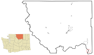
Walla Walla County is a county located in the U.S. state of Washington. As of the 2020 census, its population was 62,584. The county seat and largest city is Walla Walla. The county was formed on April 25, 1854 and is named after the Walla Walla tribe of Native Americans.

<span class="mw-page-title-main">Lincoln County, Washington</span> County in Washington, United States

Lincoln County is a county located in the U.S. state of Washington. As of the 2020 census, the population was 10,876, making it the fifth-least populous county in the state. The county seat and largest city is Davenport.

<span class="mw-page-title-main">Monrovia, Indiana</span> Town in Indiana, United States

Monrovia is a town in Monroe Township, Morgan County, in the U.S. state of Indiana. The population was 1,643 at the 2020 census, up from 1,063 in 2010.

<span class="mw-page-title-main">North Washington, Iowa</span> City in Iowa, United States

North Washington is a city in Chickasaw County, Iowa, United States. The population was 112 at the time of the 2020 census.

<span class="mw-page-title-main">Harrington, Maine</span> Town in the state of Maine, United States

Harrington is a town in Washington County, Maine, United States. The population was 962 at the 2020 census. Harrington is an old seafaring and shipbuilding village.

Northfield is a town in Washington County, Maine, United States. The population was 178 at the 2020 census.

<span class="mw-page-title-main">Ryegate, Montana</span> Town in Montana, United States

Ryegate is a town in, and the county seat of, Golden Valley County, Montana, United States. The population was 223 at the 2020 census. Ryegate is situated on the north bank of the Musselshell River.

<span class="mw-page-title-main">Brock, Nebraska</span> Village in Nebraska, United States

Brock is a village in Nemaha County, Nebraska, United States. The population was 122 at the 2020 census.

<span class="mw-page-title-main">Lyons, Pennsylvania</span> Borough in Pennsylvania, United States

Lyons is a borough that is located in Berks County, Pennsylvania, United States. The population was 439 at the time of the 2020 census.

<span class="mw-page-title-main">Grapeland, Texas</span> City in Texas, United States

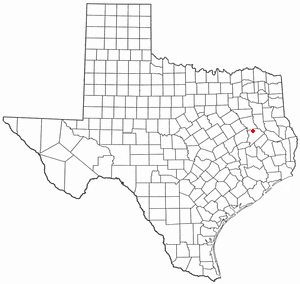
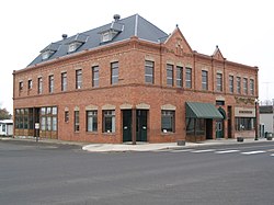
Grapeland is a city in Houston County, Texas, United States. Its population was 1,465 as of the 2020 census.

<span class="mw-page-title-main">Starbuck, Washington</span> Town in Washington, United States

Starbuck is a town in Columbia County, Washington, United States. The population was 119 at the 2020 census.

<span class="mw-page-title-main">George, Washington</span> City in Washington, United States

George is a city in Grant County, Washington, United States. The population was 809 at the 2020 census. The "humorous homage" to President George Washington has landed George, Washington on lists of unusual place names.

<span class="mw-page-title-main">Hartline, Washington</span> Town in Washington, United States

Hartline is a town in Grant County, Washington, United States. The population was 180 at the 2020 census. The high school for the Almira-Coulee/Hartline school district was located here, but moved to Coulee City, Washington in 2008. The name "Hartline" is an Americanized spelling of the German last name "Hartlein" and is an uncommon last name.

<span class="mw-page-title-main">Elmer City, Washington</span> Town in Washington, United States

Elmer City is a town in Okanogan County, Washington, United States. The population was 239 at the 2020 census.

<span class="mw-page-title-main">Nespelem, Washington</span> Town in Washington, United States

Nespelem is a town in Okanogan County, Washington, United States. The population was 180 at the 2020 census. The town is located on the Colville Indian Reservation. The name Nespelem is derived from a local Native American term meaning "large flat meadow".

<span class="mw-page-title-main">Spangle, Washington</span> City in Washington, United States

Spangle is a city in Spokane County, Washington, United States. The population was 278 at the 2010 census. The name comes from William Spangle, an early pioneer.

<span class="mw-page-title-main">Prescott, Washington</span> City in Washington, United States

Prescott is a city in central Walla Walla County, Washington. The population was 372 at the 2020 census.

<span class="mw-page-title-main">Malden, Washington</span> Town in Washington, United States

Malden is a town in Whitman County, eastern Washington, United States. The population was 216 at the 2020 census. 80 percent of the buildings were destroyed by a wildfire on September 7, 2020.

Sherwood is a town in Clark County in the U.S. state of Wisconsin. The population was 252 at the 2000 census. The unincorporated community of Nevins is located in the town.

<span class="mw-page-title-main">Coulee Dam, Washington</span> Town in Washington, United States

Coulee Dam is a town in Douglas, Grant, and Okanogan counties in the state of Washington. The Douglas County portion of Coulee Dam is part of the Wenatchee–East Wenatchee Metropolitan Statistical Area. The population was 1,211 as of the 2020 census.

References

  1. "2019 U.S. Gazetteer Files". United States Census Bureau. Retrieved August 7, 2020.
  2. 1 2 "U.S. Census website". United States Census Bureau . Retrieved January 31, 2008.
  3. "Harrington". Geographic Names Information System . United States Geological Survey, United States Department of the Interior.
  4. Phillips, James W. Washington State Place Names. 8th ed. Seattle: University of Washington Press, 1971. Print.
  5. Armstrong, Jack (1996). Wagons to Californey, 1864 : The story of Adam Edward Ludy 1831-1910 and the "Ludy Letters" 1906-1915. Denver Public Library. p. 51.{{cite book}}: CS1 maint: location missing publisher (link)
  6. Majors, Harry M. (1975). Exploring Washington. Van Winkle Publishing Co. p. 106. ISBN   978-0-918664-00-6.
  7. "US Gazetteer files: 2010, 2000, and 1990". United States Census Bureau. February 12, 2011. Retrieved April 23, 2011.
  8. "US Gazetteer files 2010". United States Census Bureau . Retrieved December 19, 2012.
  9. "NOWData - NOAA Online Weather Data". National Oceanic and Atmospheric Administration. Retrieved December 11, 2023.
  10. "Summary of Monthly Normals 1991-2020". National Oceanic and Atmospheric Administration. Retrieved December 11, 2023.
  11. United States Census Bureau. "Census of Population and Housing" . Retrieved August 31, 2014.
  12. "Census Bureau profile: Harrington, Washington". United States Census Bureau. May 2023. Retrieved May 14, 2024.
  13. "U.S. Census website". United States Census Bureau . Retrieved December 19, 2012.