
Spokane County is a county located in the U.S. state of Washington. As of the 2020 census, its population was 539,339, making it the fourth-most populous county in Washington. The largest city and county seat is Spokane, the second largest city in the state after Seattle. The county is named after the Spokane tribe.

Fall City is an unincorporated community and census-designated place (CDP) in King County, Washington, United States, 25 miles (40 km) east of Seattle. The community lies along the Snoqualmie River and Raging River. The population was 2,032 as of the 2020 census.

Spokane is the largest city in and seat of government of Spokane County, Washington, United States. It is in eastern Washington, along the Spokane River, adjacent to the Selkirk Mountains, and west of the Rocky Mountain foothills, 92 miles (148 km) south of the Canadian border, 18 miles (30 km) west of the Washington–Idaho border, and 279 miles (449 km) east of Seattle, along I-90.

Nine Mile Falls is an unincorporated community in Spokane County, Washington and Stevens County, Washington, United States. The community straddles the Spokane River 9 miles (14 km) away from downtown Spokane, at the location of a former falls that has been the site of Nine Mile Dam since 1908. Following the river, the community is located 16 miles (26 km) downstream from downtown.
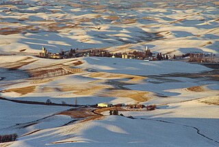
Steptoe is a small unincorporated rural town in Whitman County, Washington, United States. Steptoe is 11 miles north of the county seat, Colfax and is 43 miles south of Spokane. The ZIP Code for Steptoe is 99111.
Boistfort is an unincorporated community in the northwest United States, in Lewis County, Washington, about twenty miles (30 km) southwest of Chehalis. The original one-room school in Boistfort was established in 1853 and was the first school district in Lewis County and the Territory of Washington.

Elk is an unincorporated rural community in northern Spokane County, Washington, United States.

The history of Spokane, Washington in the northwestern United States developed because Spokane Falls and its surroundings were a gathering place for numerous cultures for thousands of years. The area's indigenous people settled there due to the fertile hunting grounds and abundance of salmon in the Spokane River. The first European to explore the Inland Northwest was Canadian explorer-geographer David Thompson, working as head of the North West Company's Columbia Department. At the nexus of the Little Spokane and the Spokane, Thompson's men built a new fur trading post, which is the first long-term European settlement in Washington state.
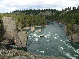
Riverside State Park is a Washington state park located 9 miles (14 km) northwest of Spokane in the community of Nine Mile Falls. The park protects 11,162 acres (4,517 ha) of Okanagan dry forest along the Spokane and Little Spokane rivers. It is the second largest state park in Washington after Mount Spokane State Park and is a popular recreation area for locals.
Dryden is a small unincorporated community in Chelan County, Washington, United States. It is situated along the Wenatchee River in the fertile Wenatchee Valley between the towns of Cashmere and Leavenworth. The community serves as a supply and shipping point for local farms and orchards.

Monitor is a small unincorporated community in Chelan County, Washington, United States. It is situated along the Wenatchee River about 8 miles upstream from its junction with the Columbia River in the fertile Wenatchee Valley.
Valley is a census-designated place and unincorporated community in Stevens County, Washington, United States. In the 2010 census the population was 146.
Mica is an unincorporated community in Spokane County, Washington, United States. Mica is located along State Route 27 12 miles (19 km) southeast of downtown Spokane. Mica had a post office with ZIP code 99023.

Fort Colville was a U.S. Army post in the Washington Territory located three miles (5 km) north of current Colville, Washington. During its existence from 1859 to 1882, it was called "Harney's Depot" and "Colville Depot" during the first two years, and finally "Fort Colville". Brigadier General William S. Harney, commander of the Department of Oregon, opened up the district north of the Snake River to settlers in 1858 and ordered Brevet Major Pinkney Lugenbeel, 9th Infantry Regiment to establish a military post to restrain the Indians lately hostile to the U. S. Army's Northwest Division and to protect miners who flooded into the area after first reports of gold in the area appeared in Western Washington newspapers in July 1855.

Buckeye is an unincorporated community in Spokane County, in the U.S. state of Washington.
Denison is an unincorporated community in Spokane County, in the U.S. state of Washington. The community is located on U.S. Route 395 19 miles due north of Downtown Spokane and about seven miles beyond that city's northern suburban developments. Denison lends its name to two roads in the area, Denison Road and Denison-Chattaroy Road, both of which intersect with Route 395 in the immediate vicinity of Denison. The city of Deer Park is four miles to the north.

Hazard is an unincorporated community in Spokane County, in the U.S. state of Washington.

Peone is an unincorporated community in Spokane County, in the U.S. state of Washington.
Rodna is an extinct town in Spokane County, in the U.S. state of Washington. The GNIS classifies it as a populated place.

