Sprague, Washington

Last updated
Sprague
Sprague, Washington
Sprague Washington IMG 1491.jpg
Lincoln County Washington Incorporated and Unincorporated areas Sprague Highlighted.svg
Location of Sprague, Washington
Coordinates: 47°17′56″N117°58′39″W / 47.29889°N 117.97750°W / 47.29889; -117.97750 Coordinates: 47°17′56″N117°58′39″W / 47.29889°N 117.97750°W / 47.29889; -117.97750
Country United States
State Washington
County Lincoln
Area
[1]
  Total1.05 sq mi (2.72 km2)
  Land1.05 sq mi (2.72 km2)
  Water0.00 sq mi (0.00 km2)
Elevation
1,903 ft (580 m)
Population
 (2010) [2]
  Total446
  Estimate 
(2019) [3]
460
  Density437.26/sq mi (168.88/km2)
Time zone UTC-8 (Pacific (PST))
  Summer (DST) UTC-7 (PDT)
ZIP code
99032
Area code(s) 509
FIPS code 53-67175 [4]
GNIS feature ID1508614 [5]
Website sprague-wa.us

Sprague is a small city in Lincoln County, Washington, United States. The population was 446 at the 2010 census. The city was platted in 1880 and named for former American Civil War Union general John Wilson Sprague.

Contents

History

Mary Queen of Heaven Catholic Church in Sprague, Washington. Sprague Mary Queend of Heaven Catholic Church IMG 1492.jpg
Mary Queen of Heaven Catholic Church in Sprague, Washington.

Sprague was first settled by William Newman, who established an inn at the location. [6]

Sprague was officially incorporated on November 28, 1883. Originally called Hoodooville after William Burrows, a local character called Hoodoo Billy, the name was changed to honor General John W. Sprague, a railroad executive. [7]

Sprague was destroyed by fire on August 3, 1895. [6] The fire and subsequent decision by the Northern Pacific Railroad to not rebuild in the town resulted in the relocation of the county seat, held by Sprague after an election in 1884, to Davenport in 1896 after a controversial vote. [8] [9]

Mary Queen of Heaven Catholic Church in Sprague, Washington was originally built in 1883. The current church was built in a Gothic Revival style and erected in 1902, just south of the site of the original church and blessed by the Bishop of Nesqually. It was placed on the National Register of Historic Places by the U.S. Department of Interior in 1990. [10]

Geography

Sprague is located at 47°17′56″N117°58′39″W / 47.29889°N 117.97750°W / 47.29889; -117.97750 (47.298974, -117.977532). [11] It is at the junction of Interstate 90 and State Route 23, northeast of Sprague Lake. It is approximately 23 miles (37 km) from Ritzville and 36 miles (58 km) from Spokane. [12]

According to the United States Census Bureau, the city has a total area of 0.63 square miles (1.63 km2), all of it land. [13]

Climate

According to the Köppen climate classification system, Sprague is located in the transition zone between a dry-summer humid continental climate, and a semi-arid climate.

Climate data for Sprague
MonthJanFebMarAprMayJunJulAugSepOctNovDecYear
Record high °F (°C)59
(15)
64
(18)
75
(24)
90
(32)
99
(37)
106
(41)
109
(43)
110
(43)
102
(39)
92
(33)
72
(22)
62
(17)
110
(43)
Average high °F (°C)34.1
(1.2)
41.6
(5.3)
51.1
(10.6)
60.8
(16.0)
70
(21)
77.6
(25.3)
87.1
(30.6)
85.7
(29.8)
76.3
(24.6)
62.4
(16.9)
45.4
(7.4)
37.4
(3.0)
60.8
(16.0)
Average low °F (°C)18.7
(−7.4)
24.7
(−4.1)
29
(−2)
34.1
(1.2)
40.7
(4.8)
46.7
(8.2)
51.1
(10.6)
49.3
(9.6)
42.4
(5.8)
34.3
(1.3)
27.8
(−2.3)
23.4
(−4.8)
35.2
(1.8)
Record low °F (°C)−31
(−35)
−33
(−36)
0
(−18)
14
(−10)
21
(−6)
27
(−3)
31
(−1)
31
(−1)
20
(−7)
4
(−16)
−15
(−26)
−21
(−29)
−33
(−36)
Average precipitation inches (mm)1.74
(44)
1.45
(37)
1.26
(32)
1.03
(26)
1.10
(28)
1.00
(25)
0.43
(11)
0.47
(12)
0.77
(20)
1.18
(30)
2.02
(51)
2.03
(52)
14.48
(368)
Average snowfall inches (cm)8.3
(21)
3.8
(9.7)
1.4
(3.6)
0.1
(0.25)
0
(0)
0
(0)
0
(0)
0
(0)
0
(0)
0.1
(0.25)
2.6
(6.6)
6.5
(17)
22.9
(58)
Average precipitation days10886763347101183
Source: [14]

Demographics

Historical population
CensusPop.
1890 1,689
1900 695−58.9%
1910 1,11059.7%
1920 822−25.9%
1930 639−22.3%
1940 6410.3%
1950 598−6.7%
1960 597−0.2%
1970 550−7.9%
1980 473−14.0%
1990 410−13.3%
2000 49019.5%
2010 446−9.0%
2019 (est.)460 [3] 3.1%
U.S. Decennial Census [15]

2010 census

As of the census [2] of 2010, there were 447 people, 197 households, and 128 families residing in the city. The population density was 707.9 inhabitants per square mile (273.3/km2). There were 236 housing units at an average density of 374.6 per square mile (144.6/km2). The racial makeup of the city was 94.2% White, 2.0% Native American, 1.6% Asian, 0.4% from other races, and 1.8% from two or more races. Hispanic or Latino of any race were 3.6% of the population.

There were 197 households, of which 26.4% had children under the age of 18 living with them, 51.8% were married couples living together, 9.1% had a female householder with no husband present, 4.1% had a male householder with no wife present, and 35.0% were non-families. 32.5% of all households were made up of individuals, and 15.2% had someone living alone who was 65 years of age or older. The average household size was 2.26 and the average family size was 2.81.

The median age in the city was 46.5 years. 23.1% of residents were under the age of 18; 4.9% were between the ages of 18 and 24; 19.9% were from 25 to 44; 32.5% were from 45 to 64; and 19.5% were 65 years of age or older. The gender makeup of the city was 51.1% male and 48.9% female.

2000 census

As of the census [4] of 2000, there were 490 people, 216 households, and 130 families residing in the city. The population density was 780.8 people per square mile (300.3/km2). There were 242 housing units at an average density of 385.6 per square mile (148.3/km2). The racial makeup of the city was 93.47% White, 2.65% Native American, 0.41% Asian, 1.63% from other races, and 1.84% from two or more races. Hispanic or Latino of any race were 2.65% of the population.

There were 216 households, out of which 26.4% had children under the age of 18 living with them, 49.5% were married couples living together, 7.4% had a female householder with no husband present, and 39.4% were non-families. 32.9% of all households were made up of individuals, and 14.4% had someone living alone who was 65 years of age or older. The average household size was 2.27 and the average family size was 2.92.

In the city, the population was spread out, with 24.5% under the age of 18, 6.5% from 18 to 24, 21.6% from 25 to 44, 26.3% from 45 to 64, and 21.0% who were 65 years of age or older. The median age was 43 years. For every 100 females, there were 95.2 males. For every 100 females age 18 and over, there were 91.7 males.

The median income for a household in the city was $29,079, and the median income for a family was $31,750. Males had a median income of $30,833 versus $21,875 for females. The per capita income for the city was $15,912. About 8.9% of families and 13.2% of the population were below the poverty line, including 21.4% of those under age 18 and 6.6% of those age 65 or over.

Notable people

Related Research Articles

Tobin, California Census-designated place in California, United States

Tobin is a census-designated place (CDP) in Plumas County, California, United States. The population was 12 at the 2010 census, up from 11 at the 2000 census.

Winchester, Indiana City in Indiana, United States

Winchester is a city in White River Township, Randolph County, in the U.S. state of Indiana. The population was 4,935 at the 2010 census. The city is the county seat of Randolph County. It is the home of Winchester Speedway.

Charlotte, Iowa City in Iowa, United States

Charlotte is a city in Clinton County, Iowa, United States. The population was 389 at the 2020 census.

Clemons, Iowa City in Iowa, United States

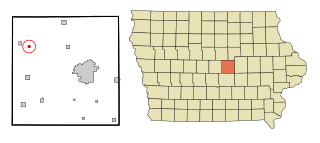
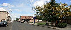
Clemons is a city in Marshall County, Iowa, United States. The population was 140 at the 2020 census.

Ogema, Minnesota City in Minnesota, United States

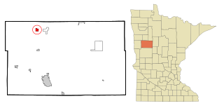
Ogema is a city in Becker County, Minnesota, United States. The population was 208 at the 2020 census.

Hitterdal, Minnesota City in Minnesota, United States

Hitterdal is a city in Clay County, Minnesota, United States. The population was 199 at the 2020 census.

St. Vincent, Minnesota City in Minnesota, United States

St. Vincent is a hamlet in Kittson County, Minnesota, United States. The population was 57 at the 2020 census.

Lakeland Shores, Minnesota City in Minnesota, United States

Lakeland Shores is a city in Washington County, Minnesota, United States. The population was 311 at the 2010 census.

Altura, Minnesota City in Minnesota, United States

Altura is a city in Winona County, Minnesota, United States. The population was 493 at the 2010 census.

Hagaman, formerly Hagamans Mills, is a village in Montgomery County, New York, United States. The population was 1,292 at the 2010 census. It is named after Joseph Hagaman, the founding father.

Vinton, Ohio Village in Ohio, United States

Vinton is a village in Gallia County, Ohio, United States. The population was 222 at the 2010 census. It is part of the Point Pleasant, WV–OH Micropolitan Statistical Area.

Pleasant Run Farms, Ohio Census-designated place in Ohio, United States

Pleasant Run Farms is a census-designated place (CDP) in Hamilton County, Ohio, United States. The population was 4,654 at the 2010 census.

Ravensdale, Washington Census-designated place in Washington, United States

Ravensdale is a census-designated place (CDP) in King County, Washington, United States. The population was 555 at the 2020 census.

Spangle, Washington City in Washington, United States

Spangle is a city in Spokane County, Washington, United States. The population was 278 at the 2010 census. The name comes from William Spangle, an early pioneer.

Prescott, Washington City in Washington, United States

Prescott is a city in central Walla Walla County, Washington. The population was 318 at the 2010 census.

Colton, Washington Town in Washington, United States

Colton is a town in Whitman County, Washington, United States. The population was 418 at the 2010 census.

Garfield, Washington Town in Washington, United States

Garfield is a city in Whitman County, Washington, United States. The population was 597 at the 2010 census, down from 641 in 2000.

Oakesdale, Washington Town in Washington, United States

Oakesdale is a town in Whitman County, Washington, United States. The population was 422 at the 2010 census.

Tekoa, Washington City in Washington, United States

Tekoa is a small farming town in Whitman County, Washington, United States. The population was 778 at the 2010 census.

Junior, West Virginia Town in West Virginia, United States

Junior is a town in Barbour County, West Virginia, United States, situated along the Tygart Valley River. The population was 520 at the 2010 census.

References

  1. "2019 U.S. Gazetteer Files". United States Census Bureau. Retrieved August 7, 2020.
  2. 1 2 "U.S. Census website". United States Census Bureau . Retrieved 2012-12-19.
  3. 1 2 "Annual Estimates of the Resident Population for Incorporated Places in Washington: April 1, 2010 to July 1, 2019". United States Census Bureau. May 2020. Retrieved May 27, 2020.
  4. 1 2 "U.S. Census website". United States Census Bureau . Retrieved 2008-01-31.
  5. "Sprague". Geographic Names Information System . United States Geological Survey.
  6. 1 2 Majors, Harry M. (1975). Exploring Washington. Van Winkle Publishing Co. p. 111. ISBN   978-0-918664-00-6.
  7. "Profile for Sprague, Washington". ePodunk. Archived from the original on 2004-11-05. Retrieved 2010-05-28.
  8. Steele, Richard F.; Rose, Arthur P. (1904). An Illustrated History of the Big Bend Country, Embracing Lincoln, Douglas, Adams and Franklin Counties. Spokane, Washington: Western Historical Publishing Company. pp.  106–110. OCLC   8990120 . Retrieved February 2, 2017 via Google Books.
  9. "National Register Information System". National Register of Historic Places . National Park Service. July 9, 2010.
  10. "US Gazetteer files: 2010, 2000, and 1990". United States Census Bureau. 2011-02-12. Retrieved 2011-04-23.
  11. Washington State Department of Transportation (2014). Washington State Highways, 2014–2015 (PDF) (Map). Olympia, Washington: Washington State Department of Transportation. § E8. Retrieved January 13, 2018.
  12. "US Gazetteer files 2010". United States Census Bureau. Archived from the original on 2012-01-24. Retrieved 2012-12-19.
  13. "SPRAGUE, WASHINGTON (457956)". Western Regional Climate Center. Retrieved November 18, 2015.
  14. United States Census Bureau. "Census of Population and Housing" . Retrieved August 31, 2014.