Hebron, New Hampshire

Last updated

Hebron, New Hampshire
Town
HebronNH TownHallAndLibrary.jpg
Town Hall and Library
Hebron Town Seal.png
Grafton-Hebron-NH.png
Coordinates: 43°41′37″N71°48′24″W / 43.69361°N 71.80667°W / 43.69361; -71.80667
Country United States
State New Hampshire
County Grafton
Incorporated 1792
VillagesHebron
East Hebron
Government
   Select Board
  • Richard James, Chair
  • Paul Hazelton
  • Patrick Moriarty
  Town AdministratorKaren Sanborn
Area
[1]
  Total19.26 sq mi (49.88 km2)
  Land17.01 sq mi (44.05 km2)
  Water2.25 sq mi (5.84 km2)  11.70%
Elevation
623 ft (190 m)
Population
 (2020) [2]
  Total632
  Density37/sq mi (14.3/km2)
Time zone UTC-5 (Eastern)
  Summer (DST) UTC-4 (Eastern)
ZIP code
03241
Area code 603
FIPS code 33-35220
GNIS feature ID0873622
Website www.hebronnh.gov

Hebron is a town in Grafton County, New Hampshire, United States. The population was 632 at the 2020 census. [2] Settlements include the town center and the village of East Hebron.

Contents

History

First settled in 1765, Hebron was incorporated in 1792 from a portion of the extinct township of Cockermouth (now Groton), combined with a portion of what was then called West Plymouth. Most early settlers arrived from New England towns, with no known first-generation emigrants from Europe. The surface was rough, the soil rather stubborn; nevertheless, farming was the primary occupation. Other industries developed after the Mayhew Turnpike was built in 1803, connecting northern towns and lumber harvesting with southern cities and mills. [3] In 1859 the population was 565, when Hebron contained one store and a tannery. [4] By the 1920s, tourism developed into a major occupation, including summer lodges and winter skiing. [5]

Geography

Hebron sits at the north end of Newfound Lake, the fourth-largest lake in New Hampshire. The Cockermouth River, the primary feeder to the lake, enters the town from Groton to the west and passes the town center before entering the lake. Hebron lies fully within the Merrimack River watershed. [6] The highest point in Hebron is a knob with an elevation of 2,240 feet (680 m) above sea level just south of the summit of Tenney Mountain, near the town's northernmost point.

The town center, Hebron village, is located near the northwestern corner of Newfound Lake, at the intersection of North Shore Road, West Shore Road, and Groton Road. New Hampshire Route 3A passes through the eastern part of town, following the east shore of Newfound Lake. The village of East Hebron is located near the northeastern end of the lake, close to the intersection of Route 3A with North Shore Road.

According to the United States Census Bureau, the town has a total area of 19.3 square miles (49.9 km2), of which 17.0 square miles (44.0 km2) are land and 2.2 square miles (5.8 km2) are water, comprising 11.70% of the town. [1]

Demographics

Historical population
CensusPop.Note
1800 281
1810 563100.4%
1820 5721.6%
1830 538−5.9%
1840 508−5.6%
1850 56511.2%
1860 475−15.9%
1870 382−19.6%
1880 329−13.9%
1890 245−25.5%
1900 214−12.7%
1910 213−0.5%
1920 184−13.6%
1930 1977.1%
1940 151−23.4%
1950 130−13.9%
1960 15317.7%
1970 23452.9%
1980 34949.1%
1990 38610.6%
2000 45918.9%
2010 60231.2%
2020 6325.0%
U.S. Decennial Census [2] [7]

As of the census [8] of 2000, there were 459 people, 206 households, and 146 families residing in the town. The population density was 27.3 inhabitants per square mile (10.5/km2). There were 517 housing units at an average density of 30.7 per square mile (11.9/km2). The racial makeup of the town was 95.86% White, 0.44% African American, 0.22% Native American, 0.22% Asian, 1.74% from other races, and 1.53% from two or more races.

There were 206 households, out of which 20.4% had children under the age of 18 living with them, 63.1% were married couples living together, 5.8% had a female householder with no husband present, and 29.1% were non-families. 23.3% of all households were made up of individuals, and 10.2% had someone living alone who was 65 years of age or older. The average household size was 2.23 and the average family size was 2.60.

In the town, the population was spread out, with 16.1% under the age of 18, 6.3% from 18 to 24, 18.7% from 25 to 44, 30.7% from 45 to 64, and 28.1% who were 65 years of age or older. The median age was 50 years. For every 100 females, there were 97.0 males. For every 100 females age 18 and over, there were 91.5 males.

The median income for a household in the town was $47,639, and the median income for a family was $54,688. Males had a median income of $37,857 versus $30,625 for females. The per capita income for the town was $30,196. About 2.6% of families and 2.8% of the population were below the poverty line, including 6.8% of those under age 18 and 2.3% of those age 65 or over.

Education

The town is within the Newfound Area School District. [9] Bridgewater-Hebron Village School is in Bridgewater. The district's secondary schools are Newfound Memorial Middle School, and Newfound Regional High School in Bristol.

Notable people

See also

Related Research Articles

<span class="mw-page-title-main">Grafton County, New Hampshire</span> County in New Hampshire, United States

Grafton County is a county in the U.S. state of New Hampshire. As of the 2020 census, the population was 91,118. Its county seat is the town of Haverhill. In 1972, the county courthouse and other offices were moved from Woodsville, a larger village within the town of Haverhill, to North Haverhill.

<span class="mw-page-title-main">Sebago, Maine</span> Town in Maine, United States

Sebago is a town in Cumberland County, Maine, United States. The population was 1,911 at the 2020 census. It is part of the Portland–South Portland–Biddeford, Maine metropolitan statistical area.

<span class="mw-page-title-main">Hebron, Maine</span> Town in the state of Maine, United States

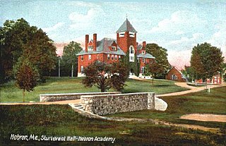
Hebron is a town in Oxford County, Maine, United States. Hebron is included in the Lewiston-Auburn, Maine metropolitan New England city and town area. The town's history has always been interconnected with Hebron Academy, a co-ed college preparatory boarding school which is located in the town's heart. The population was 1,223 at the 2020 census. There is an elementary school, Hebron Station School, located on Station Road.

Otisfield is a town in Oxford County, Maine, United States. Otisfield is included in the Lewiston-Auburn, Maine metropolitan New England city and town area. The population was 1,853 at the 2020 census. Otisfield is a summer recreation area and home to Seeds of Peace Camp and Camp Arcadia.

<span class="mw-page-title-main">Barnstead, New Hampshire</span> Town in New Hampshire, United States

Barnstead is a town in Belknap County, New Hampshire, United States. The population was 4,915 at the 2020 census, up from 4,593 at the 2010 census. Home to the Suncook Lakes, Barnstead includes the villages of Center Barnstead, Barnstead Parade and South Barnstead.

<span class="mw-page-title-main">New Hampton, New Hampshire</span> Town in New Hampshire, United States

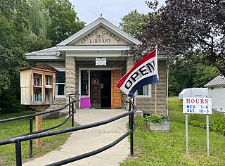
New Hampton is a town in Belknap County, New Hampshire, United States. The population was 2,377 at the 2020 census. A winter sports resort area, New Hampton is home to George Duncan State Forest and to the New Hampton School, a private preparatory school established in 1821.

<span class="mw-page-title-main">Effingham, New Hampshire</span> Town in New Hampshire, United States

Effingham is a town in Carroll County, New Hampshire, United States. At the 2020 census, the town population was 1,691, up from 1,465 at the 2010 census. Effingham includes the villages of Effingham Falls, Effingham, Center Effingham, and South Effingham. Pine River State Forest is in the south.

<span class="mw-page-title-main">Wakefield, New Hampshire</span> Town in New Hampshire, United States

Wakefield is a town in Carroll County, New Hampshire, United States. The population was 5,201 at the 2020 census. The town includes the villages of Wakefield Corner, East Wakefield, North Wakefield, Sanbornville, Union, Woodman and Province Lake. Wakefield Corner, popular with tourists, is a picturesque hilltop village of antique buildings. The state of Maine forms the eastern border of Wakefield.

<span class="mw-page-title-main">Gilsum, New Hampshire</span> Town in New Hampshire, United States

Gilsum is a town in Cheshire County, New Hampshire, United States. The population was 752 at the 2020 census. Home to Bear's Den Natural Area, Gilsum includes Gilsum Lower Village.

<span class="mw-page-title-main">Errol, New Hampshire</span> Town in New Hampshire, United States

Errol is a town in Coös County, New Hampshire, United States. The population was 298 at the 2020 census. It is located north of the White Mountains along Route 16 at its intersection of Route 26. It has a municipal airport with a single, unpaved runway.

<span class="mw-page-title-main">Alexandria, New Hampshire</span> Town in New Hampshire, United States

Alexandria is a town in Grafton County, New Hampshire, United States. The population was 1,776 at the 2020 census, up from 1,613 at the 2010 census. Newfound Lake is in the northeast corner, with Wellington State Park on the western shore. The town is home to Welton Falls State Forest. Cardigan Mountain State Park, with Mount Cardigan, is in the west. Another attraction is Mowglis Mountain, named for Rudyard Kipling's Jungle Book hero.

<span class="mw-page-title-main">Bridgewater, New Hampshire</span> Town in New Hampshire, United States

Bridgewater is a town in Grafton County, New Hampshire, United States. The population was 1,160 at the 2020 census.

<span class="mw-page-title-main">Groton, New Hampshire</span> Town in New Hampshire, United States

Groton is a town in Grafton County, New Hampshire, United States. The population was 569 at the 2020 census.

<span class="mw-page-title-main">Orange, New Hampshire</span> Town in New Hampshire, United States

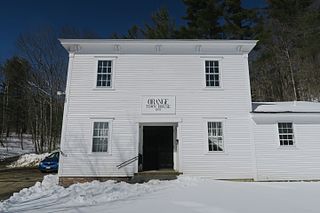
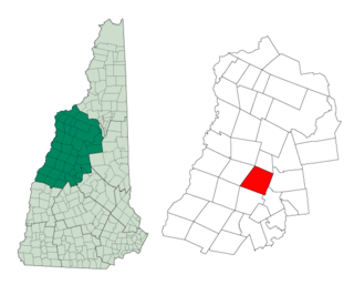
Orange is a town in Grafton County, New Hampshire, United States. The population was 277 at the 2020 census, down from 331 at the 2010 census.

<span class="mw-page-title-main">Rumney, New Hampshire</span> Town in New Hampshire, United States

Rumney is a town in Grafton County, New Hampshire, United States. The population was 1,498 at the 2020 census. The town is located at the southern edge of the White Mountain National Forest.

<span class="mw-page-title-main">Danbury, New Hampshire</span> Town in New Hampshire, United States

Danbury is a town in Merrimack County, New Hampshire, United States. The population was 1,250 at the 2020 census.

<span class="mw-page-title-main">Sutton, New Hampshire</span> Town in New Hampshire, United States

Sutton is a town in Merrimack County, New Hampshire, United States. The population was 1,978 at the 2020 census. Sutton includes the villages of Sutton Mills, North Sutton, South Sutton and East Sutton. North Sutton is home to Wadleigh State Park on Kezar Lake.

<span class="mw-page-title-main">Ryegate, Vermont</span> Town in Vermont, United States

Ryegate is a town in Caledonia County, Vermont, United States. The population was 1,165 at the 2020 census. The town contains the villages of South Ryegate, East Ryegate, and Ryegate Corner.

<span class="mw-page-title-main">Bristol, New Hampshire</span> Town in New Hampshire, United States

Bristol is a town in Grafton County, New Hampshire, United States. The population was 3,244 at the 2020 census. It is home to Wellington State Park, Sugar Hill State Forest, and Profile Falls on the Smith River. Surrounded by hills and lakes, Bristol includes the lower two-thirds of Newfound Lake, a resort area.

<span class="mw-page-title-main">Enfield, New Hampshire</span> Town in New Hampshire, United States

Enfield is a town in Grafton County, New Hampshire, United States. The population was 4,465 at the 2020 census. The town includes the villages of Enfield, Enfield Center, Upper Shaker Village, Lower Shaker Village, Lockehaven, and Montcalm.

References

  1. 1 2 "2021 U.S. Gazetteer Files – New Hampshire". United States Census Bureau. Retrieved November 29, 2021.
  2. 1 2 3 "Hebron town, Grafton County, New Hampshire: 2020 DEC Redistricting Data (PL 94-171)". U.S. Census Bureau. Retrieved November 29, 2021.
  3. New Hampshire Economic and Labor Market Information Bureau Profile
  4. Coolidge, Austin J.; John B. Mansfield (1859). A History and Description of New England. Boston, Massachusetts: A.J. Coolidge. p.  521. coolidge mansfield history description new england 1859.
  5. Collins, Ron. "A Brief History of Hebron, NH" . Retrieved May 28, 2007.
  6. Foster, Debra H.; Batorfalvy, Tatianna N.; Medalie, Laura (1995). Water Use in New Hampshire: An Activities Guide for Teachers. U.S. Department of the Interior and U.S. Geological Survey.
  7. "Census of Population and Housing". Census.gov. Retrieved June 4, 2016.
  8. "U.S. Census website". United States Census Bureau . Retrieved January 31, 2008.
  9. "Central Office". Newfound Area School District. Retrieved April 11, 2020.