
The Willamette River is a major tributary of the Columbia River, accounting for 12 to 15 percent of the Columbia's flow. The Willamette's main stem is 187 miles (301 km) long, lying entirely in northwestern Oregon in the United States. Flowing northward between the Oregon Coast Range and the Cascade Range, the river and its tributaries form the Willamette Valley, a basin that contains two-thirds of Oregon's population, including the state capital, Salem, and the state's largest city, Portland, which surrounds the Willamette's mouth at the Columbia.
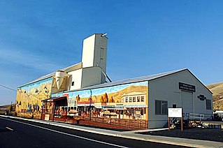
Heppner is a city in, and the county seat of, Morrow County, Oregon, United States. As of 2010, the population was 1,291. Heppner is part of the Pendleton-Hermiston Micropolitan Area. Heppner is named after Henry Heppner, a prominent Jewish-American businessman.

Ione is a city in Morrow County, Oregon, United States. The population was 329 at the 2010 census. It is part of the Pendleton–Hermiston Micropolitan Statistical Area.

Lexington is a city in Morrow County, Oregon, United States. The population was 238 at the 2010 census. It is part of the Pendleton–Hermiston Micropolitan Statistical Area.

Detroit Dam is a gravity dam on the North Santiam River between Linn County and Marion County, Oregon. It is located in the Cascades, about 5 mi (8.0 km) west of the city of Detroit. It was constructed between 1949 and 1953 by the United States Army Corps of Engineers. The dam created 400-foot (120 m) deep Detroit Lake, more than 9 miles (14 km) long with 32 miles (51 km) of shoreline.

The Calapooia River is an 80-mile (130 km) tributary of the Willamette River in the U.S. state of Oregon.

Hurricane Diane was the first Atlantic hurricane to cause more than an estimated $1 billion in damage, including direct costs and the loss of business and personal revenue. It formed on August 7 from a tropical wave between the Lesser Antilles and Cape Verde. Diane initially moved west-northwestward with little change in its intensity, but began to strengthen rapidly after turning to the north-northeast. On August 12, the hurricane reached peak sustained winds of 105 mph (165 km/h), making it a Category 2 hurricane. Gradually weakening after veering back west, Diane made landfall near Wilmington, North Carolina, as a strong tropical storm on August 17, just five days after Hurricane Connie struck near the same area. Diane weakened further after moving inland, at which point the United States Weather Bureau noted a decreased threat of further destruction. The storm turned to the northeast, and warm waters from the Atlantic Ocean helped produce record rainfall across the northeastern United States. On August 19, Diane emerged into the Atlantic Ocean southeast of New York City, becoming extratropical two days later and completely dissipating by August 23.

New Bullards Bar Dam is a variable radius concrete arch dam constructed in the early 1960s in California on the North Yuba River. Located near the town of Dobbins in Yuba County, the dam forms the New Bullards Bar Reservoir, which can hold about 969,600 acre⋅ft (1.1960×10⁹ m3) of water. The dam serves for irrigation, drinking water and hydroelectric power generation.
Floods in the United States are generally caused by excessive rainfall, excessive snowmelt, and dam failure. Below is a list of flood events that were of significant impact to the country during the 20th century, from 1900 through 1999, inclusive.

The Middle Fork Willamette River is one of several forks that unite to form the Willamette River in the western part of the U.S. state of Oregon. It is approximately 115 miles (185 km) long, draining an area of the Cascade Range southeast of Eugene, which is at the southern end of the Willamette Valley.
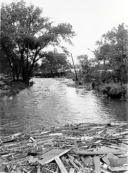
The Black Hills Flood of 1972, also known as the Rapid City Flood, was the most detrimental flood in South Dakota history, and one of the deadliest floods in U.S. history. The flood took place on June 9–10, 1972 in the Black Hills of Western South Dakota. 15 inches (380 mm) of rain in a small area over the Black Hills caused Rapid Creek and other waterways to overflow. Severe flooding of residential and commercial properties in Rapid City occurred when Canyon Lake Dam became clogged with debris and failed in the late evening hours of June 9 resulting in 238 deaths and 3,057 injuries. Over 1,335 homes and 5,000 automobiles were destroyed. The value of property damage was estimated to be over US$160 million in 1972 dollars. Flooding also occurred in Battle, Spring, Bear Butte, and Boxelder creeks.

The 1979 Easter flood was one of the most costly and devastating floods to ever occur in Mississippi, United States, with $500–700 million in damages. $1.87 billion in 2020 dollars. It was the result of the Pearl River being overwhelmed by severe rain upstream. Floodwaters sent the Pearl River 15 feet above flood stage. More than 17,000 residents of Jackson, Flowood, Pearl, Richland, and other settlements in the Jackson metropolitan area were forced from their homes. The flooding of the Pearl River placed most of the streets of Jackson, the state's capital city, under several feet of water.

Willow Creek Dam is a dam in Morrow County of the U.S. state of Oregon, located just east of Heppner's city limits. It was the first major dam in the United States constructed of roller-compacted concrete.

Big Butte Creek is a 12-mile-long (19 km) tributary of the Rogue River in the U.S. state of Oregon. It drains approximately 245 square miles (635 km2) of Jackson County. Its two forks, the North Fork and the South Fork, both begin high in the Cascade Range near Mount McLoughlin. Flowing predominantly west, they meet near the city of Butte Falls. The main stem flows generally northwest until it empties into the Rogue Falls was incorporated in 1911, and remains the only incorporated town within the watershed's boundaries.

Willow Creek is a 79-mile (127 km) long tributary of the Columbia River, located in the U.S. state of Oregon. It drains 880 square miles (2,279 km2) of Morrow and Gilliam counties. Arising in the Blue Mountains, it flows generally northwest to its confluence with the Columbia River upstream of Arlington.

The Christmas flood of 1964 was a major flood in the United States' Pacific Northwest and some of Northern California between December 18, 1964, and January 7, 1965, spanning the Christmas holiday. Considered a 100-year flood, it was the worst flood in recorded history on nearly every major stream and river in coastal Northern California and one of the worst to affect the Willamette River in Oregon. It also affected parts of southwest Washington, Idaho, and Nevada. In Oregon, 17 or 18 people died as a result of the disaster, and it caused hundreds of millions of dollars in damage. The flooding on the Willamette covered 152,789 acres (61,831.5 ha). The National Weather Service rated the flood as the fifth most destructive weather event in Oregon in the 20th century. California Governor Pat Brown was quoted as saying that a flood of similar proportions could "happen only once in 1,000 years," and it was often referred to later as the Thousand Year Flood. The flood killed 19 people, heavily damaged or completely devastated at least 10 towns, destroyed all or portions of more than 20 major highway and county bridges, carried away millions of board feet of lumber and logs from mill sites, devastated thousands of acres of agricultural land, killed 4,000 head of livestock, and caused $100 million in damage in Humboldt County, California, alone.

The Parvin Bridge is a covered bridge located in Lane County, Oregon, U.S. near Dexter. It was built in 1921 as a single-lane 75-foot (23 m) bridge across Lost Creek, a tributary of the Middle Fork Willamette River.

Hills Creek Dam is a dam about 4 miles (6.4 km) southeast of Oakridge in Lane County, Oregon, United States. It impounds Hills Creek Reservoir, which has a surface area of 2,735 acres (1,107 ha) and a shoreline of roughly 44 miles (71 km), on the Middle Fork Willamette River.

The South Fork McKenzie River is a tributary, about 31 miles (50 km) long, of the McKenzie River in the U.S. state of Oregon. It begins at about 4,500 feet (1,400 m) above sea level near Mink Lake in the Three Sisters Wilderness of the Cascade Range. Flowing northwest within Lane County, it meets the McKenzie River about 60 miles (97 km) from the larger river's confluence with the Willamette River.
Fall Creek Lake is a reservoir in Lane County, in the U.S. state of Oregon. It is about 22 miles (35 km) southeast of Eugene on Fall Creek, immediately upstream from Unity Bridge, a covered bridge. The communities of Unity, at the bridge site, and Lowell, south of Unity, are near the lake. The unincorporated community of Jasper is further downstream, below the confluence of Fall Creek with the Middle Fork Willamette River.
