Related Research Articles

Pottersville is an unincorporated hamlet in Howell County, Missouri, United States. It is located approximately ten miles west of West Plains. Besides a few homes, only a post office and fire station are located there. The ZIP Code for Pottersville is 65790.
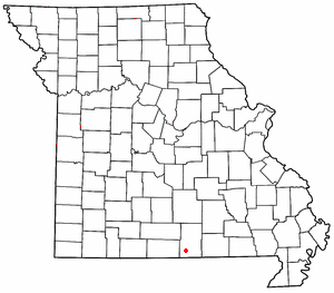
Hocomo is a small unincorporated community in Howell County, Missouri, United States. It is located approximately thirteen miles southwest of West Plains on U.S. Route 160.
Coldspring is an unincorporated community in north central Douglas County, in the Ozarks of southern Missouri. The community is located on Missouri Route 76 and Clever Creek.
Larissa is an historic town located along Hunter Creek in Douglas County, Missouri, United States. The GNIS classifies it as a populated place. Larissa was located on the north part of the floodplain of Hunter Creek, along county road VV-210, at an elevation of 935 feet. The location is approximately one mile upstream (northwest) of the Crystal Springs fish hatchery.

Topaz is an unincorporated community in northeast Douglas County, Missouri, United States. Topaz is an old mill site located on the North Fork River. Access to the community is from Missouri Route 76 via either Missouri Route EE or Missouri Route E.
Arditta is an unincorporated community in southwest Howell County, in the Ozarks of southern Missouri. Arditta is located on U.S. Route 160 between Egypt Grove and Caulfield. It is approximately twelve miles southwest of West Plains.
Bennetts Bayou is a stream in the U.S. states of Arkansas and Missouri. The stream source is in Howell County, Missouri, just south of US Route 160 west of Hocomo. The stream flows southwest into Ozark County, Missouri, and under Missouri Route 142 on the east side of Bakersfield. It then flows south through the extreme northwest corner of Fulton County, Arkansas, and into the northwest corner of Baxter County, Arkansas. It continues to the southwest and enters the northeast arm of Norfork Lake to the east of Gamaliel, Arkansas. The similarly named Bennetts River runs subparallel to Bennetts Bayou just to the southeast.
Bly is an extinct town in southwest Howell County, in the Ozarks of southern Missouri. The location is on Bennetts Bayou, approximately 3.5 miles southeast of Caulfield.
Chapel is an unincorporated community in northeastern Howell County, in the U.S. state of Missouri. The community is located on county road 2680, east of Missouri Route W, and approximately four miles south-southeast of Mountain View. The Chapel Hill Church and historic school lie just west of Route W.
Crider is an unincorporated community in western Howell County, in the U.S. state of Missouri. Crider is approximately ten miles west of West Plains and about two miles northwest of Pottersville and is located on Missouri Route AD.
Cull is an unincorporated community in eastern Howell County, in the U.S. state of Missouri. The community is located on a county road south of U.S. Route 160 and is approximately nine miles east of West Plains, near the eastern border of the county. The community of Rover in Oregon County lies about two miles to the east.
Cureall is an unincorporated community in Howell County, in the U.S. state of Missouri.
Egypt Grove is an unincorporated community in southwest Howell County, in the U.S. state of Missouri. The community is located along US Route 160, east of Caulfield.
Frankville is an unincorporated community in southern Howell County, in the U.S. state of Missouri. The community is located at the intersection of U.S. Route 60 and county road 8660, approximately two miles southeast of West Plains.
Fruitville is an unincorporated community in southeast Howell County, in the U.S. state of Missouri.
Leota is an unincorporated community in southwestern Howell County, in the U.S. state of Missouri. The community is located on Missouri Route 142 and is approximately two miles north of the Missouri - Arkansas state line.
Noblett Creek is a stream in Douglas and Howell counties in the Ozarks of southern Missouri.
Sterling is an unincorporated community in northwest Howell County, in the U.S. state of Missouri. The community is located adjacent to the railroad just east of U.S. Route 63, approximately one mile south of the county line.
Trask is an unincorporated community in northern Howell County, in the U.S. state of Missouri. The community is located on Missouri Route V, approximately one mile south of U.S. Route 60 between Willow Springs and Mountain View.
Benton Township is an inactive township in Howell County, in the U.S. state of Missouri.
References
- 1 2 U.S. Geological Survey Geographic Names Information System: Horton
- ↑ Siloam Springs, Missouri 7.5 Minute Topographic Quadrangle, USGS, 2004
- ↑ "Howell County Place Names, 1928–1945 (archived)". The State Historical Society of Missouri. Archived from the original on June 24, 2016. Retrieved October 10, 2016.
{{cite web}}: CS1 maint: bot: original URL status unknown (link) - ↑ "Post Offices". Jim Forte Postal History. Retrieved October 10, 2016.
Municipalities and communities of Howell County, Missouri, United States | ||
|---|---|---|
| Cities |  | |
| Townships | ||
| CDPs | ||
| Other unincorporated communities | ||
| Ghost towns | ||
36°52′13″N92°04′27″W / 36.87028°N 92.07417°W
| | This Howell County, Missouri state location article is a stub. You can help Wikipedia by expanding it. |