The local service district of the same name, which included only part of the parish, was amalgamated into the Regional Municipality of Grand Tracadie–Sheila on July 1, 2014,[8] causing some misunderstanding of its status.
on the north by a line beginning at the northwestern corner of grant 255 on the western side of Lavigne Road, a bit south of the end of Chemin Gauvin est, easterly to a point on the prolongation of the rear line of the tier of grants on the eastern bank of the Pokemouche River, 300 chains (6.035km) inland, then southeasterly along the grants to Grande Anse, then southeasterly and southwesterly along the shore to the mouth of the Pokemouche River;
on the south by a line beginning at the Old Tracadie Gully, across Tracadie Bay, up LeBouthillier Brook to Route 11, then southwesterly along grant lines to the north line of grant 145 on the north side of Route 160 and along the grant to where it strikes the Saint-Isidore Parish line;
on the west by a line running northwesterly from Saint-Raymond Road, at the southeastern corner of grant 144 on the south side of Route 160, to the southern line of Range 6 in the Paquetville South Settlement, which runs along the south side of Val-Doucet Road farther west, then northeastern and northwesterly along Range 6 to the Pokemouche River; then northeasterly in a direct line to the southernmost corner of the tier of grants west of Lavigne Road, then northwest along the rear of four grants in the tier to the northern line of Inkerman.
Governance
The Regional Municipality of Tracadie includes the southern part of the parish, the boundary running generally along the rear lines of grants along the Pokemouche River, Cowans Creek, and the South Branch Pokemouche River below McConnell Brook; the barrier islands along the outer edge of Tracadie Bay are also part of the regional municipality. From east to west, the communities of Four Roads, Six Roads, Boudreau Road, Sainte-Rose-Gloucester, Gaspereau, and Haut-Sainte-Rose are within the regional municipality, as is the part of Pont-Landry within this parish.
In addition to basic LSD services, all LSDs assessed for the voluntary services of street lighting and community & recreation services.[17] Running east to west, the local service districts and Indian reserve were:
Inkerman Centre contained the peninsula east of the South Branch Pokemouche River, all of Inkerman Parish east from the junction of Nardini Road and Route 345, and all of Caraquet Parish south of the wetlands along Jules Brook. The community of Inkerman comprises the peninsula, Inkerman Ferry the area east of the Pokemouche River; the former community of Pokemouche Junction, centred around Nardini Road and Allée Connolly, has been absorbed by Inkerman Ferry. Established in 1970 to provide street lighting.[18] Originally it included Four Roads as far west as Green Point Road but was otherwise much smaller than today; it expanded in 1987 on all sides,[19] lost Évangéline in 1988,[20] and lost Four Roads to Tracadie in 2015.[21] Now part of Shippagan.[5]
Evangéline (French Évangéline) included grants along Route 345 from the junction with Nardini Road west to the junction with Route 11, as well as a short stretch of Route 335. Established in 1988 from parts of Inkerman Centre and Pokemouche;[20] the corresponding taxing authority was Évangeline.[17] The name Waugh appears on the area cadastral map; the Waugh post office was renamed Evangeline in 1949.[22] Now mostly part of Caraquet, with a small area in the southeastern border part of Shippagan.[5]
Pokemouche straddled the Pokemouche River along Route 11; the southern portion comprised grants along the western side of the South Branch Pokemouche River north of McConnell Brook, along the Pokemouche between South Branch Portage River and Cowans Creek, and along Pokemouche Cross Road; the northern portion included Pokemouche River grants west to the mouth of Whalens Brook and a strip of interior grants between the end of Basile Road and Route 350. The communities of Pokemouche and South River were in the southern portion, Upper Pokemouche in the northern; Walsh's Island was between the two. Established in 1987,[23] when it included all of Evangéline west of Route 335. Now part of Shippagan.[5]
Landry Office straddled the Pokemouche, with Landry Centre Road bridging the river. The southern portion included all Pokemouche River grants from the mouth of Cowans Creek to the Indian reserve, grants along the western, northern, and southern sides of Cowans Creek, and a half-dozen interior grants in its southeastern corner. The northern portion contained Pokemouche River grants from Whalens Brook to the end of Landry Road and interior grants along Landry, Godin, and Haché Roads and the west side of Basile Road. A small area west of the Indian reserve was isolated from the rest of the LSD and lacked highway access. The communities of Cowans Creek and Landry were in the southern portion, Haché Road in the northern portion. Established in 1988,[24] it originally ended near Gliddens Brook; Cowans Creek and the southeastern corner were added in 1989.[25] Now mostly part of Caraquet, with the westernmost two grants now part of Tracadie.[5]
Maltempec comprised all grants north of the Pokemouche River and west of the end of Landry Road. Its single community was originally spelt Maltampec. Established in 1987.[23] Now part of Hautes-Terres.[5]
The Pokemouche 13Indian reserve is on the southern bank of the Pokemouche River, west of the end of Cowans Creek. The reserve belongs to the Esgenoopetitj First Nation and was originally much larger, stretching east to Nowlans Brook; there is no highway access.
The following former LSDs were all annexed by Tracadie in 2014.[21]
The LSD of the parish of Inkerman was established in 1968,[26] when it included the entire parish. By 1989 it was reduced to the community of Six Roads and western Four Roads.
Sainte-Rose was established in 1988,[27] it was formed around the Ste. Rose Settlement, including the communities of Boudreau Road, Gaspereau, Haut-Sainte-Rose, and Sainte-Rose.
Pont Landry was established in 1986[28] and included the parish south of the Ste. Rose Settlement and grants along Route 355, and west of Carroll Road.
Communities
Communities at least partly within the parish;[14][15][16]bold indicates an incorporated entity or Indian reserve; italics indicate a name no longer in official use
Saumarez is a geographic parish in Gloucester County, New Brunswick, Canada.
Aberdeen is a geographic parish in Carleton County, New Brunswick, Canada, located in the interior east of the Saint John River.
A local service district (LSD) was a provincial administrative unit for the provision of local services in the Canadian province of New Brunswick. LSDs originally covered areas of the province that maintained some services but were not made municipalities when the province's former county municipalities were dissolved at the start of 1967; eventually all of rural New Brunswick was covered by the LSD system. They were defined in law by the Local Service Districts Regulation of the Municipalities Act. In 2017, the Municipalities Act was replaced by the Local Governance Act, which continued the Local Service Districts Regulation.
Pokemouche was a Canadian local service district in Gloucester County, in the northeast of New Brunswick, in the Acadian peninsula; it included the communities of Cowans Creek, Pokemouche, and Upper Pokemouche. It is now part of the town of Caraquet.
Bathurst is a geographic parish in Gloucester County, New Brunswick, Canada.
New Bandon is a geographic parish in Gloucester County, New Brunswick, Canada.
Paquetville is a geographic parish in Gloucester County, New Brunswick, Canada.
Caraquet is a geographic parish in Gloucester County, New Brunswick, Canada.
Shippegan is a geographic parish in Gloucester County, New Brunswick, Canada. Located in the northeastern corner of the province at the end of the Acadian Peninsula, the parish consists of the three main islands of Taylor, Lamèque, and Miscou, along with several smaller islands and tidal wetlands; Taylor Island is now joined to the mainland by an isthmus, which is crossed by a causeway.
Saint-Isidore is a geographic parish in Gloucester County, New Brunswick, Canada.
Allardville is a geographic parish in Gloucester County, New Brunswick, Canada,
Peel is a geographic parish in Carleton County, New Brunswick, Canada, situated on the eastern bank of the Saint John River.
Brighton is a geographic parish in Carleton County, New Brunswick, Canada, northeast of Woodstock, extending from the eastern bank of the Saint John River to the York County line.
Woodstock is a geographic parish in Carleton County, New Brunswick, Canada, surrounding the town of the same name on its landward side.
Pont-Landry is a community in Gloucester County, New Brunswick, located at the junction of Inkerman, Saint-Isidore, and Saumarez Parishes. It was grouped with the communities of Boishébert, Gaspereau, and Losier Settlement in 1986 to form the local service district of Pont Landry, which was annexed by the Regional Municipality of Grand Tracadie–Sheila in 2014.
Saint George is a geographic parish in Charlotte County, New Brunswick, Canada, located between St. Stephen and Saint John.
Dumbarton is a geographic parish in Charlotte County, New Brunswick, Canada, located inland north of St. George and south of Harvey.
Saint James is a geographic parish in Charlotte County, New Brunswick, Canada, located north of St. Stephen.
Saint David is a geographic parish in Charlotte County, New Brunswick, Canada, located northeast of St. Stephen and northwest of Saint Andrews.
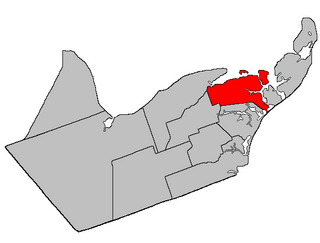
The Regional Municipality of Tracadie is the first and only regional municipality in the province of New Brunswick, Canada.
References
1 2 "Census Profile". Statistics Canada. 26 October 2022. Retrieved 29 October 2022.
↑ The Territorial Division Act[2] divides the province into 152 parishes, the cities of Saint John and Fredericton, and one town of Grand Falls. The Interpretation Act[3] clarifies that parishes include any local government within their borders.
↑ "18 Vic. c. 47 An Act for dividing the Parish of Saumarez, in the County of Gloucester, into two separate Parishes.". Acts of the General Assembly of Her Majesty's Province of New Brunswick, Passed in the Month of November, 1854, and in the Months of February, March, and April, 1855. Fredericton: Government of New Brunswick. 1855. pp.176–177. Available as a free ebook from Google Books.
↑ "33 Vic. c. 11 An Act to alter the Division Line between the Parishes of Saumarez and Inkerman, in the County of Gloucester.". Acts of the General Assembly of Her Majesty's Province of New Brunswick Passed in the Months of March & April 1870. Fredericton: Government of New Brunswick. 1870. p.20. Available as a free ebook from Google Books.
↑ "44 Vic. c. 34 An Act to erect part of the Parishes of Saumarez and Inkerman, in the County of Gloucester, into a separate Parish.". Acts of the General Assembly of Her Majesty's Province of New Brunswick. Passed in the Month of March 1881. Fredericton: Government of New Brunswick. 1881. pp.70–72. Available as a free ebook from Google Books.
1 2 3 4 "No. 18". Provincial Archives of New Brunswick. Department of Natural Resources and Energy Development. Retrieved 8 June 2021. Remainder of parish on maps 19 and 30 at same site.
1 2 3 4 "055"(PDF). Transportation and Infrastructure. Government of New Brunswick. Retrieved 8 June 2021. Remainder of parish on mapbooks 074–076 and 095 at same site.
↑ "Item: 16046". Library and Archives Canada. Retrieved 24 July 2021.
1 2 "Regulation 87-104 under the Municipalities Act (O.C. 87-642)". The Royal Gazette. 145. Fredericton: The Queen's Printer: 1288–1302. 19 August 1987.
↑ "Regulation 88-41 under the Municipalities Act (O.C. 88-118)". The Royal Gazette. 146. Fredericton: The Queen's Printer: 417–420. 6 April 1988.
↑ "Regulation 89-116 under the Municipalities Act (O.C. 89-649)". The Royal Gazette. 147. Fredericton: The Queen's Printer: 417–420. 20 September 1989.
↑ "Regulation 68–64 under the Municipalities Act (O. C. 68–592)". The Royal Gazette. 126. Fredericton: 407–408. 24 July 1968.
↑ "Regulation 88-149 under the Municipalities Act (O.C. 88-578)". The Royal Gazette. 146. Fredericton: The Queen's Printer: 1023–1024. 27 July 1988.
↑ "Regulation 86-1 under the Municipalities Act (O.C. 86-2)". The Royal Gazette. 144. Fredericton: The Queen's Printer: 95–103. 22 January 1986.
This page is based on this Wikipedia article Text is available under the CC BY-SA 4.0 license; additional terms may apply. Images, videos and audio are available under their respective licenses.


