
Savernake Forest stands on a Cretaceous chalk plateau between Marlborough and Great Bedwyn in Wiltshire, England. Its area is approximately 4,500 acres.
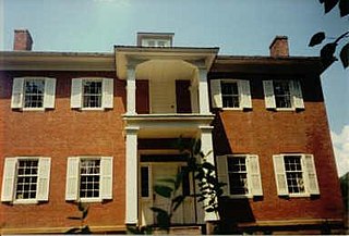
The Lusk Home and Mill Site was the first development in present Turkey Run State Park, Indiana's second oldest state park.

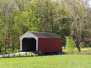
The Nevins Covered Bridge is a single span Burr Arch Truss covered bridge that crosses Little Raccoon Creek on County Road 130 East, just southeast of Catlin, Indiana. It was built in 1920 by Joseph A. Britton and Son. Prior to the reconstruction of the Bridgeton Bridge in 2006, the Nevins Bridge was the newest covered bridge in Parke County.

The Beeson Covered Bridge originally crossed Roaring Creek, one mile (1.6 km) northwest of Marshall, Indiana, on County Road 216, in Washington Township, Parke County. The bridge was moved to its current location in Billie Creek Village in December 1979.

The Jackson Covered Bridge also known as the Rockport Covered Bridge is located in the 'forgotten town' of Rockport, northwest of Bloomingdale, Parke County, Indiana, USA.

The Leatherwood Station Covered Bridge is a single span double Burr Arch Truss covered bridge structure that was built by Joseph A. Britton & Son in 1899. Originally it had sandstone abutments but when it was moved to Billie Creek Village they were replaced with concrete abutments with sandstone showing.

The Melcher Covered Bridge, also known as the "Klondyke Covered Bridge", "Marion Covered Bridge", or the "Leatherwood Covered Bridge" crosses Leatherwood Creek east of Montezuma, Indiana, and is a single-span Burr Arch Truss covered bridge structure that was built by Joseph J. Daniels in 1896.

The Narrows Covered Bridge crosses Sugar Creek at the eastern edge of Turkey Run State Park and is a single span Burr Arch Truss covered bridge structure that was built by Joseph A. Britton in 1882.
The Phillips Covered Bridge is southeast of Montezuma, Indiana in Parke County, Indiana and crosses Rocky Run, also known as Big Pond Creek. Unlike the rest of the bridges of Parke County, it is a single span King Post bridge structure, having no arches, that was built by Joseph A. Britton in 1909.
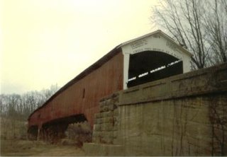
The West Union Covered Bridge formerly carried Tow Path Road over Sugar Creek north-northeast of Montezuma, Indiana. The two-span Burr Arch Truss covered bridge structure was built by Joseph J. Daniels in 1876. It is notable for being the longest standing covered bridge in Parke County, and one of the nation's best-preserved examples of the Burr truss.
Joseph Albert Britton (1839–1929), most commonly known as J.A. Britton, was a builder of bridges in Indiana. He created many works that survive and are listed on the U.S. National Register of Historic Places.

The Ballard Road Covered Bridge is a historic wooden covered bridge in the southwestern part of the U.S. state of Ohio. Built in the late nineteenth century and since bypassed, the bridge has been named a historic site.
The Armiesburg Covered Bridge was on the south side of Armiesburg, Indiana. The Long Truss with arch covered bridge structure was built by Henry Wolf in 1907 and destroyed by the Great Flood of 1913.
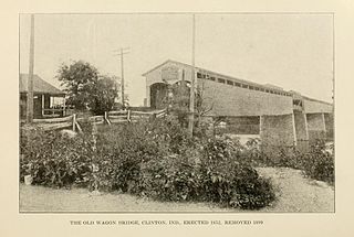
The Clinton Covered Bridge was on the east side of Clinton, Indiana. The Long Truss style bridge with double lanes, triple covered spans and one 70 foot draw span was built by Hirem Bishop in 1852-53 and destroyed by electric cutting wire in 1899.
The Greencastle Road Covered Bridge is a "lost" bridge in the truest of senses, not only is it gone, but the exact records of where, if at all, it existed have been lost to history. Henry Wolf probably built it sometime before 1863 on a section of Greencastle Road that no longer exists.
The Turkey Run Covered Bridge was north of Marshall, Indiana. The single-span Modified Queen Truss covered bridge structure was built by Joseph J. Daniels in 1865, 1866 or 1884, according to several conflicting sources, and dismantled in 1914 by order of the Parke County Commissioners, the abutments remain. It was one of two Queen Truss type covered bridges, the other being the JH Russell Covered Bridge
The Lusk Covered Bridge was once located north of Marshall, Indiana, United States. Two single-span dual lane Lattice Truss covered bridges were located at the site, one of which replaced the other. Salmon Lusk constructed the first bridge in 1840, and after its destruction by flood in 1847, Lusk constructed the second. Both bridges were located on private land; the only other such covered bridges in Parke County were the State Sanitorium Covered Bridge, the JH Russell Covered Bridge, and the Clinton Toll Bridge.
