Jessup Covered Bridge

Last updated
Jessup Covered Bridge
Coordinates 39°39′49.87″N87°15′23.68″W / 39.6638528°N 87.2565778°W / 39.6638528; -87.2565778 Coordinates: 39°39′49.87″N87°15′23.68″W / 39.6638528°N 87.2565778°W / 39.6638528; -87.2565778
CrossesLittle Raccoon Creek
Locale Parke, Indiana, United States
Official nameJessup Covered Bridge
Named for Jessup, Indiana
WGCB Number14-61-06x [1]
Characteristics
Total length175 ft (53 m)155ft +10ft overhangs on each end
Width16 ft (4.9 m) [2]
Height13 ft (4.0 m)
History
Constructed byJefferson P. Van Fossen
Built1910
Destroyed1989 Flood
Location
Jessup Covered Bridge

The Jessup Covered Bridge was north of Jessup, Indiana. The single-span Burr Arch covered bridge structure was built by the Jefferson P. Van Fossen in 1910 and destroyed by flood in 1989. [2]

Contents

History

Construction

Originally the main road to Rockville from Terre Haute was through Coxville, with this bridge it was shorter to go through what was originally Jessup Station. [3] By 1969 though the bridge had been bypassed and closed by a new bridge. However, a December flood in 1969 would give the bridge a new leese on life.

Move

It was decided, after the Adams Covered Bridge was destroyed by flood waters in 1969, that the Jessup Covered bridge could replace it. Elmer Buchta of Buchta Trucking was contracted for the 12-mile move to the Adams Bridge.

After several days of removing the south abutment, the bridge was jacked onto two sets of multi-wheeled dollies. On Tuesday, February 3, 1970, the Jessup Covered Bridge started its road trip to what would be its home for the next 20 years, until it would meet the same fate as its predecessor. The bridge was first pulled to Catlin where it took 3 1/2 hours to get around the two 90-degree turns. That night it was held at Catlin before making its way to Rockville on Wednesday. The trip was slowed because of three county bridges it had to pass over. The Highway Department had already applied a foot and a half of dirt on the bridge deck to lift the bridge over the concrete rails but additional cribbing was needed to allow the bridge to clear. That night the bridge was parked in front of Ferguson Lumber on S. Market Street on the south side of Rockville. On Thursday the bridge moved uphill to the courthouse square. The traffic lights had already been moved and the bridge made its right-hand turn onto U.S. 36. From there it probably traveled down U.S. 36 to Adams Road, which leads to the Adams Farm and the new location for the bridge.( 39°46′52″N87°8′42″W / 39.78111°N 87.14500°W / 39.78111; -87.14500 ) Over the weekend, however, disaster struck in the form of warming weather which allowed to ground to thaw, which brought the move to a halt until temperatures dropped on Monday so that by Wednesday the ground had refroze. On Wednesday the bridge was able to be pulled across a big field and jacked into its new location 12 miles upstream from its original location. [2]

Destruction

In 1989 a large tree broke the arches and collapsed the bridge. Again, like the Adams Covered Bridge before it, it was washed downstream, under the Sanitorium Covered Bridge and over the U.S. 36 concrete bridge, the former site of the Plank Road Covered Bridge, and jammed further downstream. By September 1990, Parke County Incorporated was attempting to acquire the Cedar Ford Covered Bridge from Shelby County, Indiana. Meanwhile, the County Highway Superintendent, Tom Martin, stated that the laminated floor boards, which is the major recurring maintenance performed on the covered bridges, had been recovered from the bridge but because the bridge would be too hard to recover from the creek bed and it was unneeded for other bridge repairs that it evidently wouldn't be removed intact. [2] [4]

See also

Related Research Articles

Parke County, Indiana County in Indiana, United States

Parke County lies in the western part of the U.S. state of Indiana along the Wabash River. The county was formed in 1821 out of a portion of Vigo County. According to the 2010 census, the population was 17,339, an increase of 0.6% from 17,241 in 2000. The county seat is Rockville.

Rockville, Indiana Town in Indiana, United States

Rockville is a town in Adams Township, Parke County, in the U.S. state of Indiana. The population was 2,607 at the 2010 census. The town is the county seat of Parke County. It is known as "The Covered Bridge Capital of the World".

Adams Township, Parke County, Indiana Township in Indiana, United States

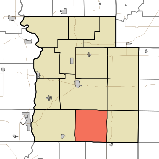
Adams Township is one of thirteen townships in Parke County, Indiana, United States. As of the 2010 census, its population was 5,825 and it contained 2,062 housing units.

Nevins Covered Bridge Place in Indiana listed on National Register of Historic Places

The Nevins Covered Bridge is a single span Burr Arch Truss covered bridge that crosses Little Raccoon Creek on County Road 130 East, just southeast of Catlin, Indiana. It was built in 1920 by Joseph A. Britton and Son. Prior to the reconstruction of the Bridgeton Bridge in 2006, the Nevins Bridge was the newest covered bridge in Parke County.

Crooks Covered Bridge

The Crooks Covered Bridge is a single span Burr Arch Truss structure that crosses Little Raccoon Creek built in 1855-1856 by Henry Wolf just southeast of Rockville, Indiana.

Beeson Covered Bridge

The Beeson Covered Bridge originally crossed Roaring Creek, one mile (1.6 km) northwest of Marshall, Indiana, on County Road 216, in Washington Township, Parke County. The bridge was moved to its current location in Billie Creek Village in December 1979.

Catlin Covered Bridge

The Catlin Covered Bridge is a single span Burr Arch truss covered bridge structure that was built by Clark McDaniel in 1907.

Sanitorium Covered Bridge Place in Indiana listed on National Register of Historic Places

The Sanitorium Covered Bridge is a bridged located east of Rockville, Indiana. The single-span Burr Arch covered bridge structure was built by Joseph A. Britton in 1913.

Wilkins Mill Covered Bridge Place in Indiana listed on National Register of Historic Places

The Wilkins Mill Covered Bridge is north of Rockville, Indiana. The single span Burr Arch Truss covered bridge structure was built by William Hendricks in 1906. The bridge is 120 feet (37 m) long, 16 feet (4.9 m) wide, and 13 feet (4.0 m) high.

Florida Township, Parke County, Indiana Township in Indiana, United States

Florida Township is one of thirteen townships in Parke County, Indiana, United States. As of the 2010 census, its population was 2,378 and it contained 1,073 housing units.

Raccoon Township, Parke County, Indiana Township in Indiana, United States

Raccoon Township is one of thirteen townships in Parke County, Indiana, United States. As of the 2010 census, its population was 659 and it contained 345 housing units.

Union Township, Parke County, Indiana Township in Indiana, United States

Union Township is one of thirteen townships in Parke County, Indiana, United States. As of the 2010 census, its population was 1,562 and it contained 1,451 housing units.

Joseph Albert Britton (1839–1929), most commonly known as J.A. Britton, was a builder of bridges in Indiana. He created many works that survive and are listed on the U.S. National Register of Historic Places.

Billie Creek Village is (was) a 70-acre open-air living history museum and park, filled with 38 historical buildings and structures, and hundred of antiques and artifacts. It is located at 39.7614298°N 87.2019582°W near Rockville, Adams Township, Parke County, Indiana in the area known as the "Covered Bridge Capital of the World" for the county's 31 covered bridges. It was formed in 1964/1965 by residents of Parke County, and opened its doors in 1969. The group Parke County, Inc. helped to form it, and a separate group, Billie Creek Village, Inc, was formed for operating it. The village took its name from nearby Williams Creek.

The Adams Covered Bridge was east of Rockville, Indiana. The single-span Burr Arch covered bridge structure was built by the Adams Construction in 1907 and destroyed by flood in 1969.

The Dooley Station Covered Bridge was east of Dooley Station, Indiana. The Burr arch truss style single span covered bridge crossed Little Raccoon Creek and was built by W.C. Carty in 1917 and destroyed by arson in 1960.

The Hollandsburg Covered Bridge was southeast of Hollandsburg, Indiana. The single-span Burr Arch covered bridge structure was built by J. J. Daniels in 1872 and torn down in 1930 during the expansion of U.S. Route 36 (US 36).

The Howard Covered Bridge was east of Rockville, Indiana. The single-span Burr Arch covered bridge structure was built by J. A. Britton in 1913 and torn down in 1931 or 1932 during the expansion of U.S. Route 36 (US 36).

The Plank Road Covered Bridge was east of Rockville, Indiana. The single-span Burr Arch covered bridge structure was built by Henry Wolf in either 1854 or 1859 and destroyed in the Great Flood of 1913.

The Weisner Covered Bridge was southwest of Catlin, Indiana. The single-span King Post covered bridge structure was built by Joseph A. Britton in 1908 and destroyed by flood in 1957.

References

  1. "Jessup Covered Bridge". Indiana Covered Bridges. Retrieved 19 February 2015.
  2. 1 2 3 4 "Jessup Covered Bridge". Covered Bridges. Archived from the original on 19 February 2015. Retrieved 19 February 2015.
  3. "Florida Township 1905". Indiana Genealogy Web. Retrieved 19 February 2015.
  4. "Jessup Covered Bridge 14-61-06x". Bridgehunter. July 8, 2010. Retrieved March 13, 2015.