
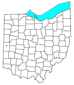
Darke County is a county in the U.S. state of Ohio. As of the 2020 census, the population was 51,881. Its county seat and largest city is Greenville. The county was created in 1809 and later organized in 1817. It is named for William Darke, an officer in the American Revolutionary War. Darke County comprises the Greenville, OH Micropolitan Statistical Area, which is also included in the Dayton-Springfield-Sidney, OH Combined Statistical Area.
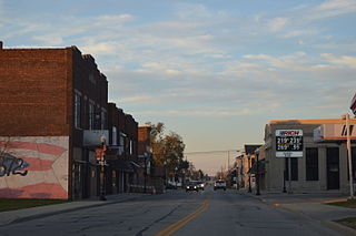
Bradford is a village in Darke and Miami counties in the U.S. state of Ohio. The population was 1,796 at the 2020 census.

The Stillwater River is a 69.3-mile-long (111.5 km) tributary of the Great Miami River in western Ohio in the United States. Via the Great Miami and Ohio rivers, it is part of the Mississippi River watershed.
Adams Township is one of the twenty townships of Darke County, Ohio, United States. The 2020 census found 3,343 people in the township.

State Route 242 was an east–west state highway in the west-central portion of Ohio. The western terminus of the route was at U.S. Route 127 approximately 5 miles (8.0 km) north of Greenville. Its eastern terminus was at a T-intersection with SR 121 adjacent to Darke County Airport about 1.5 miles (2.4 km) southwest of Versailles.
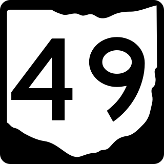
State Route 49 is a state highway in the western part of the U.S. state of Ohio. It begins in Drexel, an area within the city of Trotwood, at US 35 and runs northwesterly to Greenville, and then runs roughly along near the western edge of the state near the Indiana state line to the Michigan state line where it meets with Michigan's M-49.

State Route 502 is an east–west state highway in western Ohio, a U.S. state. The western terminus of the highway is at the Indiana state line approximately six miles (9.7 km) south of Union City, with the road continuing into the Hoosier State being locally maintained Greenville Pike. The eastern terminus of the highway is in downtown Greenville at a traffic circle where it meets a conglomeration of four other state highways: SR 49, 118, 121 and 571.

Brown Township is one of the twenty townships of Darke County, Ohio, United States. The 2020 census found 2,056 people in the township.
Greenville Township is one of the twenty townships of Darke County, Ohio, United States. The 2020 census found 17,159 people in the township, 4,373 of whom lived in the unincorporated parts of the township.

Jackson Township is one of the twenty townships of Darke County, Ohio, United States. The 2020 census found 2,668 people in the township.

Liberty Township is one of the twenty townships of Darke County, Ohio, United States. The 2020 census found 986 people in the township.

Richland Township is one of the twenty townships of Darke County, Ohio, United States. The 2020 census found 820 people in the township.

Twin Township is one of the twenty townships of Darke County, Ohio, United States. The 2020 census found 4,249 people in the township.

Van Buren Township is one of the twenty townships of Darke County, Ohio, United States. The 2020 census found 1,528 people in the township.

Clay Township is one of the nine townships of Montgomery County, Ohio, United States. As of the 2020 census the population was 8,876.

Dawn is an unincorporated community in northern Richland Township, Darke County, Ohio, United States. It lies at the intersection of U.S. Route 127 with Burch Road. It is located between the villages of Ansonia and Versailles, approximately 8 miles (12.75 km) north of Greenville, the county seat of Darke County.
Beamsville in an unincorporated community in central Richland Township, Darke County, Ohio, United States. It lies near the intersection of U.S. Route 127 and the Stillwater River, approximately 6 miles north of Greenville, the county seat of Darke County.

Ohio State Route 118 (SR 118) is a 55.30-mile (89.00 km) long north–south state highway in western Ohio, connecting the cities of Greenville and Van Wert. SR 118 runs northward through Darke, Mercer and Van Wert counties, starting from a roundabout with SR 49, SR 571, SR 121 and SR 502 in Greenville. The route crosses through the farming villages of Ansonia, St. Henry, Rossburg and Ohio City as well as the villages of Coldwater and Rockford. Just north of Rossburg, SR 118 serves Eldora Speedway, a clay oval racetrack owned by NASCAR driver Tony Stewart. The northern terminus of SR 118 is at a junction with U.S. Route 127 in the city of Van Wert.
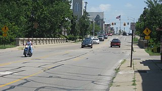
The Broadway Bridge is a historic arch bridge that spans Greenville Creek on the edge of downtown Greenville, a city in the far western part of the U.S. state of Ohio. Constructed in the early twentieth century, it carries one of the city's most important streets and connects the city's northern and southern sections. One of several large concrete bridges designed by a Cleveland engineer, it has been named a historic site.
Poplar Ridge is an unincorporated community in Darke County, in the U.S. state of Ohio.

