Pitsburg, Ohio

Last updated

Pitsburg, Ohio
Jefferson and Merrie in Pitsburg.jpg
Jefferson Street south of downtown
Darke County Ohio incorporated and unincorporated areas Pitsburg highlighted.svg
Location in Darke County and the state of Ohio.
Coordinates: 39°59′14″N84°29′16″W / 39.98722°N 84.48778°W / 39.98722; -84.48778
Country United States
State Ohio
County Darke
Township Monroe
Area
[1]
  Total0.17 sq mi (0.44 km2)
  Land0.17 sq mi (0.44 km2)
  Water0.00 sq mi (0.00 km2)
Elevation
[2]
1,024 ft (312 m)
Population
 (2020)
  Total381
  Density2,254.44/sq mi (868.32/km2)
Time zone UTC-5 (Eastern (EST))
  Summer (DST) UTC-4 (EDT)
ZIP code
45358
Area code(s) 937, 326
FIPS code 39-62890 [3]
GNIS feature ID2399680 [2]

Pitsburg is a village in Monroe Township, Darke County, Ohio, United States. The population was 381 at the 2020 census.

Contents

History

Pitsburg was founded under the name of "Arnettsville" in the 19th century, but it languished: an author writing in 1880 described it as "liv[ing] only in name and story." [4] The community revived over the next several decades; by 1914, the village included a school, a Methodist Episcopal church, multiple businesses, and over two hundred residents. [5]

Geography

According to the United States Census Bureau, the village has a total area of 0.19 square miles (0.49 km2), all land. [6]

Demographics

Historical population
CensusPop.Note
1900 157
1910 24052.9%
1920 30225.8%
1930 3113.0%
1940 305−1.9%
1950 35917.7%
1960 3949.7%
1970 46217.3%
1980 460−0.4%
1990 425−7.6%
2000 392−7.8%
2010 388−1.0%
2020 381−1.8%
U.S. Decennial Census [7]

2010 census

As of the census [8] of 2010, there were 388 people, 148 households, and 113 families living in the village. The population density was 2,042.1 inhabitants per square mile (788.5/km2). There were 160 housing units at an average density of 842.1 per square mile (325.1/km2). The racial makeup of the village was 98.7% White, 0.3% Native American, and 1.0% Asian.

There were 148 households, of which 37.2% had children under the age of 18 living with them, 62.2% were married couples living together, 10.1% had a female householder with no husband present, 4.1% had a male householder with no wife present, and 23.6% were non-families. 20.3% of all households were made up of individuals, and 8.1% had someone living alone who was 65 years of age or older. The average household size was 2.62 and the average family size was 2.98.

The median age in the village was 40.3 years. 27.1% of residents were under the age of 18; 7% were between the ages of 18 and 24; 24.5% were from 25 to 44; 27.6% were from 45 to 64; and 13.9% were 65 years of age or older. The gender makeup of the village was 47.9% male and 52.1% female.

2000 census

As of the census [3] of 2000, there were 392 people, 135 households, and 108 families living in the village. The population density was 2,066.5 inhabitants per square mile (797.9/km2). There were 158 housing units at an average density of 832.9 per square mile (321.6/km2). The racial makeup of the village was 97.96% White, 1.28% Native American, 0.26% Pacific Islander, and 0.51% from two or more races. Hispanic or Latino of any race were 0.51% of the population.

There were 135 households, out of which 44.4% had children under the age of 18 living with them, 69.6% were married couples living together, 5.9% had a female householder with no husband present, and 20.0% were non-families. 19.3% of all households were made up of individuals, and 3.7% had someone living alone who was 65 years of age or older. The average household size was 2.90 and the average family size was 3.25.

In the village, the population was spread out, with 36.0% under the age of 18, 6.6% from 18 to 24, 34.4% from 25 to 44, 19.4% from 45 to 64, and 3.6% who were 65 years of age or older. The median age was 28 years. For every 100 females there were 101.0 males. For every 100 females age 18 and over, there were 109.2 males.

The median income for a household in the village was $51,591, and the median income for a family was $62,273. Males had a median income of $44,500 versus $26,563 for females. The per capita income for the village was $18,763. None of the families and 4.0% of the population were living below the poverty line, including no under eighteens and 28.0% of those over 64.

Related Research Articles

<span class="mw-page-title-main">Darke County, Ohio</span> County in Ohio, United States

Darke County is a county in the U.S. state of Ohio. As of the 2020 census, the population was 51,881. Its county seat and largest city is Greenville. The county was created in 1809 and later organized in 1817. It is named for William Darke, an officer in the American Revolutionary War. Darke County comprises the Greenville, OH Micropolitan Statistical Area, which is also included in the Dayton-Springfield-Sidney, OH Combined Statistical Area.

<span class="mw-page-title-main">Ansonia, Ohio</span> Village in Ohio, United States

Ansonia is a village in Darke County, Ohio, United States. The population was 1,160 at the 2020 census.

<span class="mw-page-title-main">Arcanum, Ohio</span> Village in Ohio, United States

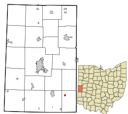
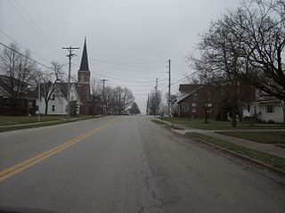
Arcanum is a village in Darke County, Ohio, United States. The population was 2,457 at the 2020 census.

<span class="mw-page-title-main">Castine, Ohio</span> Village in Ohio, United States

Castine is a village in Darke County, Ohio, United States. The population was 110 at the 2020 census.

<span class="mw-page-title-main">Gordon, Ohio</span> Village in Ohio, United States

Gordon is a village in Darke County, Ohio, United States. The population was 245 at the 2020 census.

<span class="mw-page-title-main">Hollansburg, Ohio</span> Village in Ohio, United States

Hollansburg is a village in Darke County, Ohio, United States. The population was 243 at the 2020 census.

<span class="mw-page-title-main">Ithaca, Ohio</span> Village in Ohio, United States

Ithaca is a village in Darke County, Ohio, United States. The population was 81 at the 2020 census.

<span class="mw-page-title-main">New Weston, Ohio</span> Village in Ohio, United States

New Weston is a village in Darke County, Ohio, United States. The population was 124 at the 2020 census.

<span class="mw-page-title-main">North Star, Ohio</span> Village in Ohio, United States

North Star is a village in Darke County, Ohio, United States. The population was 224 at the 2020 census.

<span class="mw-page-title-main">Osgood, Ohio</span> Village in Ohio, United States

Osgood is a village in Darke County, Ohio, United States. The population was 306 at the 2020 census.

<span class="mw-page-title-main">Palestine, Ohio</span> Village in Ohio, United States

Palestine is a village in Darke County, Ohio, United States. The population was 180 at the 2020 census.

<span class="mw-page-title-main">Rossburg, Ohio</span> Village in Ohio, United States

Rossburg is a village in Darke County, Ohio, United States. The population was 159 at the 2020 census.

<span class="mw-page-title-main">Yorkshire, Ohio</span> Village in Ohio, United States

Yorkshire is a village in Darke County, Ohio, United States. The population was 95 at the 2020 census.

<span class="mw-page-title-main">Antioch, Ohio</span> Village in Ohio, United States

Antioch is a village in Monroe County, Ohio, United States. The population was 71 at the 2020 census.

<span class="mw-page-title-main">Lewisville, Ohio</span> Village in Ohio, United States

Lewisville is a village in Monroe County, Ohio, United States. The population was 184 at the 2020 census.

<span class="mw-page-title-main">Stafford, Ohio</span> Village in Ohio, United States

Stafford is a village in Monroe County, Ohio, United States. The population was 71 at the 2020 census.

<span class="mw-page-title-main">Woodsfield, Ohio</span> Village in Ohio, United States

Woodsfield is a village and the county seat of Monroe County, Ohio, United States, located about 30 miles (48 km) northeast of Marietta. The population was 2,210 at the 2020 census.

<span class="mw-page-title-main">Wilson, Ohio</span> Village in Ohio, United States

Wilson is a village in Belmont and Monroe counties in the U.S. state of Ohio. The population was 129 at the 2020 census. It is part of the Wheeling metropolitan area.

<span class="mw-page-title-main">Bradford, Ohio</span> Village in Ohio, United States

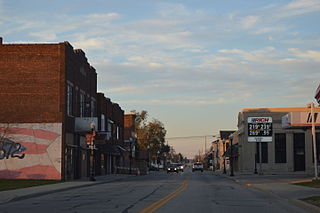
Bradford is a village in Darke and Miami counties in the U.S. state of Ohio. The population was 1,796 at the 2020 census.

<span class="mw-page-title-main">Burkettsville, Ohio</span> Village in Ohio, United States

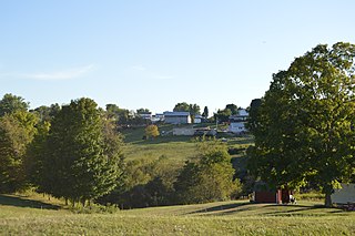
Burkettsville is a village in Darke and Mercer counties in the U.S. state of Ohio. The population was 272 at the 2020 census.

References

  1. "ArcGIS REST Services Directory". United States Census Bureau. Retrieved September 20, 2022.
  2. 1 2 U.S. Geological Survey Geographic Names Information System: Pitsburg, Ohio
  3. 1 2 "U.S. Census website". United States Census Bureau . Retrieved January 31, 2008.
  4. The History of Darke County, Ohio. W. H. Beers & Company. 1880. pp.  455.
  5. Wilson, Frazer Ells (1914). History of Darke County, Ohio, from its earliest settlement to the present time, Vol. 1. Milford, Ohio: Hobart Publishing Company. pp. 622–623.
  6. "US Gazetteer files 2010". United States Census Bureau. Archived from the original on January 12, 2012. Retrieved January 6, 2013.
  7. "Census of Population and Housing". Census.gov. Retrieved June 4, 2015.
  8. "U.S. Census website". United States Census Bureau . Retrieved January 6, 2013.

"Franklin Monroe". www.franklin-monroe.k12.oh.us. Franklin Monroe LSD. March 11, 2023. Retrieved March 11, 2023.