Josefina, Zamboanga del Sur

Last updated
Josefina
Municipality of Josefina
Seal of Josefina.png
Ph locator zamboanga del sur josefina.png
Map of Zamboanga del Sur with Josefina highlighted
OpenStreetMap
Josefina, Zamboanga del Sur
Philippines location map (square).svg
Red pog.svg
Josefina
Location within the Philippines
Coordinates: 8°12′52″N123°32′38″E / 8.2144°N 123.5439°E / 8.2144; 123.5439 Coordinates: 8°12′52″N123°32′38″E / 8.2144°N 123.5439°E / 8.2144; 123.5439
Country Philippines
Region Zamboanga Peninsula
Province Zamboanga del Sur
District 1st district
Founded November 11, 1977
Named for Josefina Herrera Cerilles
Barangays 14 (see Barangays)
Government
[1]
  Type Sangguniang Bayan
   Mayor Catalino A. Adapon
   Vice Mayor Alberto M. Etulle
   Representative Divina Grace C. Yu
   Municipal Council
Members
   Electorate 8,124 voters (2022)
Area
[2]
  Total56.35 km2 (21.76 sq mi)
Elevation
645 m (2,116 ft)
Highest elevation
1,434 m (4,705 ft)
Lowest elevation
288 m (945 ft)
Population
 (2020 census) [3]
  Total12,205
  Density220/km2 (560/sq mi)
   Households
2,986
Economy
   Income class 5th municipal income class
   Poverty incidence
28.08
% (2018) [4]
   Revenue 73.48 million (2020)
   Assets 292 million (2020)
   Expenditure 62.44 million (2020)
   Liabilities 96.94 million (2020)
Service provider
  ElectricityZamboanga del Sur 1 Electric Cooperative (ZAMSURECO 1)
Time zone UTC+8 (PST)
ZIP code
7027
PSGC
IDD : area code +63(0)62
Native languages Subanon
Cebuano
Chavacano
Tagalog
Website www.zds-josefina.gov.ph

Josefina, officially the Municipality of Josefina (Cebuano : Lungsod sa Josefina; Subanen: Benwa Josefina; Chavacano: Municipalidad de Josefina; Tagalog : Bayan ng Josefina), is a 5th class municipality in the province of Zamboanga del Sur, Philippines. According to the 2020 census, it has a population of 12,205 people. [3]

Contents

History

In the early years the lands of which is now Josefina was part of the Municipality of Aurora. In later years, Molave separated from Aurora and became a town; at that time Tambulig and the area now within the jurisdiction of the present municipality were still part of the former. Some years later Tambulig became independent and was recognized as a township with the land of Josefina still tagged as part of its territories. During this time the first Visayan settlers came to live in the area. These settlers came from Tudela, Misamis Occidental, a barrio part of Tambulig was established and was named Bagong Tudela.

Some years passed and the Paredes family, one of the first settlers, was able to acquire properties there and named it "Salug Estate". A member of the family was a rubber technologist at that time and worked in Borneo. He brought along his lessons and expertise and together with the locals, "the Subanen", planted his land with Rubber Trees. By then the Rubber Technologist, Nicholas Paredes, coined the name "New Town" for the new rubber plantation.

With the rubber plantation, the place was then locally called as "Gumahan". This became a new trading center and small businesses came bustling. With the increased activity in this new location it was then christened as "Upper Bagong Tudela". This eventually became the center of the new community.

In the early 1970s, the people of Gumahan and its outlying barrios made a move, through the leadership of Nicholas Paredes, to create a town. They were able to submit the proposal to congress, through the sponsorship of then Cong. Cerilles, and it passed the 2nd congressional reading. When scheduled for the 3rd and final congressional reading, Martial Law was declared dissolving the Congress.

On November 11, 1978, by virtue of Presidential Decree 1240, 13 barangays of Tambulig were separated and formed into the independent municipality Josefina. [5] During this time Nicholas Paredes (who was the point person of the township proposal) stood as the first Mayor (appointed). Mayor Paredes donated the land where now stands the Market Area, the school, the Municipal Hall and the Catholic Church. The town center is also located within the properties of the Paredes family.

Josefina was named after the mother of Congressman Cerilles, who was a known educator in Zamboanga Del Sur.

As to this day Josefina is still commonly known as "Gumahan".

Geography

Barangays

Josefina is politically subdivided into 14 barangays.

  • Bogo Calabat
  • Dawa (Diwa)
  • Ebarle
  • Gumahan (Poblacion)
  • Leonardo
  • Litapan
  • Lower Bagong Tudela
  • Mansanas
  • Moradji
  • Nemeño
  • Nopulan
  • Sebukang
  • Tagaytay Hill
  • Upper Bagong Tudela (Poblacion)

Climate

Climate data for Josefina, Zamboanga del Sur
MonthJanFebMarAprMayJunJulAugSepOctNovDecYear
Average high °C (°F)24
(75)
25
(77)
26
(79)
27
(81)
27
(81)
27
(81)
26
(79)
27
(81)
27
(81)
26
(79)
26
(79)
25
(77)
26
(79)
Average low °C (°F)19
(66)
19
(66)
19
(66)
20
(68)
21
(70)
21
(70)
20
(68)
20
(68)
20
(68)
20
(68)
20
(68)
20
(68)
20
(68)
Average precipitation mm (inches)69
(2.7)
44
(1.7)
37
(1.5)
29
(1.1)
87
(3.4)
137
(5.4)
131
(5.2)
141
(5.6)
143
(5.6)
134
(5.3)
68
(2.7)
53
(2.1)
1,073
(42.3)
Average rainy days9.97.67.48.121.626.526.426.625.824.315.110.4209.7
Source: Meteoblue [6]

Demographics

Population census of Josefina
YearPop.±% p.a.
1980 6,755    
1990 7,591+1.17%
1995 9,024+3.29%
2000 8,758−0.64%
2007 10,796+2.93%
2010 10,826+0.10%
2015 11,799+1.65%
2020 12,205+0.67%
Source: Philippine Statistics Authority [7] [8] [9] [10]

Economy

Related Research Articles

<span class="mw-page-title-main">Lakewood, Zamboanga del Sur</span> Municipality in Zamboanga del Sur, Philippines

Lakewood, officially the Municipality of Lakewood, is a 4th class municipality in the province of Zamboanga del Sur, Philippines. According to the 2020 census, it has a population of 21,559 people. 

<span class="mw-page-title-main">Buug</span> Municipality in Zamboanga Sibugay, Philippines

Buug, officially the Municipality of Buug, is a 3rd class municipality in the province of Zamboanga Sibugay, Philippines. According to the 2020 census, it has a population of 38,425 people. 

<span class="mw-page-title-main">Baliguian</span> Municipality in Zamboanga del Norte, Philippines

Baliguian, officially the Municipality of Baliguian, is a 3rd class municipality in the province of Zamboanga del Norte, Philippines. According to the 2020 census, it has a population of 23,771 people. 

<span class="mw-page-title-main">Gutalac</span> Municipality in Zamboanga del Norte, Philippines

Gutalac, officially the Municipality of Gutalac, is a 2nd class municipality in the province of Zamboanga del Norte, Philippines. According to the 2020 census, it has a population of 36,090 people. 

<span class="mw-page-title-main">Kalawit</span> Municipality in Zamboanga del Norte, Philippines

Kalawit, officially the Municipality of Kalawit, is a 4th class municipality in the province of Zamboanga del Norte, Philippines. According to the 2020 census, it has a population of 23,812 people. 

<span class="mw-page-title-main">La Libertad, Zamboanga del Norte</span> Municipality in Zamboanga del Norte, Philippines

La Libertad, officially the Municipality of La Libertad, is a 5th class municipality in the province of Zamboanga del Norte, Philippines. According to the 2020 census, it has a population of 8,119 people. 

<span class="mw-page-title-main">Labason</span> Municipality in Zamboanga del Norte, Philippines

Labason, officially the Municipality of Labason, is a 3rd class municipality in the province of Zamboanga del Norte, Philippines. According to the 2020 census, it has a population of 43,934 people. 

<span class="mw-page-title-main">Piñan</span> Municipality in Zamboanga del Norte, Philippines

Piñan, officially the Municipality of Piñan, is a fourth-class municipality in the province of Zamboanga del Norte, Philippines. According to the 2020 census, it has a population of 20,221 people. 

<span class="mw-page-title-main">Tampilisan</span> Municipality in Zamboanga del Norte, Philippines

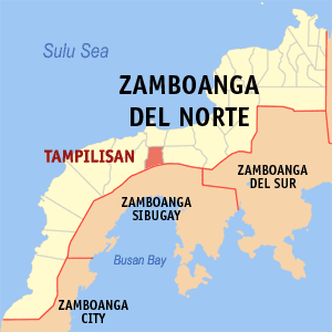
Tampilisan, officially the Municipality of Tampilisan, is a 4th class municipality in the province of Zamboanga del Norte, Philippines. According to the 2020 census, it has a population of 24,680 people. 

<span class="mw-page-title-main">Aurora, Zamboanga del Sur</span> Municipality in Zamboanga del Sur, Philippines

Aurora, officially the Municipality of Aurora, is a 2nd class municipality in the province of Zamboanga del Sur, Philippines. According to the 2020 census, it has a population of 52,995 people. 

<span class="mw-page-title-main">Dumingag</span> Municipality in Zamboanga del Sur, Philippines

Dumingag, officially the Municipality of Dumingag, is a 2nd class municipality in the province of Zamboanga del Sur, Philippines. According to the 2020 census, it has a population of 48,881 people. 

<span class="mw-page-title-main">Dimataling</span> Municipality in Zamboanga del Sur, Philippines

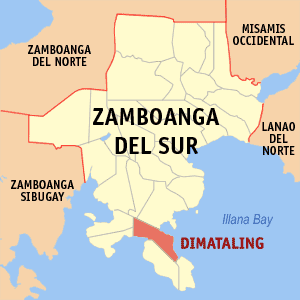
Dimataling, officially the Municipality of Dimataling, is a 4th class municipality in the province of Zamboanga del Sur, Philippines. According to the 2020 census, it has a population of 31,340 people. 

<span class="mw-page-title-main">Guipos</span> Municipality in Zamboanga del Sur, Philippines

Guipos, officially the Municipality of Guipos, is a 4th class municipality in the province of Zamboanga del Sur, Philippines. According to the 2020 census, it has a population of 21,738 people. 

<span class="mw-page-title-main">Mahayag</span> Municipality in Zamboanga del Sur, Philippines

Mahayag, officially the Municipality of Mahayag, is a 3rd class municipality in the province of Zamboanga del Sur, Philippines. According to the 2020 census, it has a population of 48,258 people. 

<span class="mw-page-title-main">Molave, Zamboanga del Sur</span> Municipality in Zamboanga del Sur, Philippines

Molave, officially known as the Municipality of Molave, is a 1st class municipality in the province of Zamboanga del Sur, Philippines. In the 2020 census, it had 53,140 people.  It is in the eastern part of the province of Zamboanga del Sur, and has an area of 21,685 hectares. The name "Molave" refers to the tree that was common in the area. Its economy is focused on agricultural production, and 1,378.5 hectares of fertile land is irrigated and planted with rice. Corn, coconut, cassava, banana, camote and various vegetables are also grown. These are marketed to neighboring towns and cities, and reach Cebu. Due to its strategic location, Molave is becoming the commercial hub of the Salug Valley. It is the most populous municipality in Zamboanga del Sur, and the third most populous in Region IX.

<span class="mw-page-title-main">San Miguel, Zamboanga del Sur</span> Municipality in Zamboanga del Sur, Philippines

San Miguel, officially the Municipality of San Miguel, is a 4th class municipality in the province of Zamboanga del Sur, Philippines. According to the 2020 census, it has a population of 19,838 people. 

<span class="mw-page-title-main">San Pablo, Zamboanga del Sur</span> Municipality in Zamboanga del Sur, Philippines

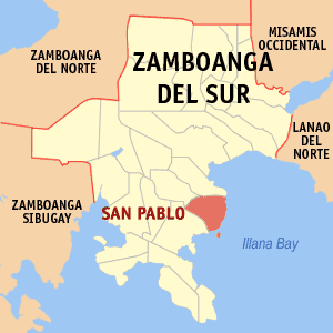
San Pablo, officially the Municipality of San Pablo, is a 4th class municipality in the province of Zamboanga del Sur, Philippines. According to the 2020 census, it has a population of 26,648 people. 

<span class="mw-page-title-main">Sominot</span> Municipality in Zamboanga del Sur, Philippines

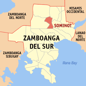
Sominot, officially the Municipality of Sominot, is a 5th class municipality in the province of Zamboanga del Sur, Philippines. According to the 2020 census, it has a population of 19,061 people. 

<span class="mw-page-title-main">Tabina</span> Municipality in Zamboanga del Sur, Philippines

Tabina, officially the Municipality of Tabina, is a 4th class municipality in the province of Zamboanga del Sur, Philippines. According to the 2020 census, it has a population of 25,734 people. 

<span class="mw-page-title-main">Tambulig</span> Municipality in Zamboanga del Sur, Philippines

Tambulig, officially the Municipality of Tambulig, is a 4th class municipality in the province of Zamboanga del Sur, Philippines. According to the 2020 census, it has a population of 37,480 people. 

References

  1. Municipality of Josefina | (DILG)
  2. "2015 Census of Population, Report No. 3 – Population, Land Area, and Population Density" (PDF). Philippine Statistics Authority. Quezon City, Philippines. August 2016. ISSN   0117-1453. Archived (PDF) from the original on May 25, 2021. Retrieved July 16, 2021.
  3. 1 2 Census of Population (2020). "Region IX (Zamboanga Peninsula)". Total Population by Province, City, Municipality and Barangay. PSA . Retrieved 8 July 2021.
  4. "PSA Releases the 2018 Municipal and City Level Poverty Estimates". Philippine Statistics Authority. 15 December 2021. Retrieved 22 January 2022.
  5. "Presidential Decree No. 1240: Creating the Municipality of Josefina in the Province of Zamboanga del Sur". The Lawphil Project. Arellano Law Foundation, Inc. Retrieved 21 July 2014.
  6. "Aurora: Average Temperatures and Rainfall". Meteoblue. Retrieved 1 May 2020.
  7. Census of Population (2015). "Region IX (Zamboanga Peninsula)". Total Population by Province, City, Municipality and Barangay. PSA . Retrieved 20 June 2016.
  8. Census of Population and Housing (2010). "Region IX (Zamboanga Peninsula)". Total Population by Province, City, Municipality and Barangay. NSO . Retrieved 29 June 2016.
  9. Censuses of Population (1903–2007). "Region IX (Zamboanga Peninsula)". Table 1. Population Enumerated in Various Censuses by Province/Highly Urbanized City: 1903 to 2007. NSO.
  10. "Province of Zamboanga del Sur". Municipality Population Data. Local Water Utilities Administration Research Division. Retrieved 17 December 2016.
  11. "Poverty incidence (PI):". Philippine Statistics Authority. Retrieved December 28, 2020.
  12. https://psa.gov.ph/sites/default/files/NSCB_LocalPovertyPhilippines_0.pdf; publication date: 29 November 2005; publisher: Philippine Statistics Authority.
  13. https://psa.gov.ph/sites/default/files/2003%20SAE%20of%20poverty%20%28Full%20Report%29_1.pdf; publication date: 23 March 2009; publisher: Philippine Statistics Authority.
  14. https://psa.gov.ph/sites/default/files/2006%20and%202009%20City%20and%20Municipal%20Level%20Poverty%20Estimates_0_1.pdf; publication date: 3 August 2012; publisher: Philippine Statistics Authority.
  15. https://psa.gov.ph/sites/default/files/2012%20Municipal%20and%20City%20Level%20Poverty%20Estima7tes%20Publication%20%281%29.pdf; publication date: 31 May 2016; publisher: Philippine Statistics Authority.
  16. https://psa.gov.ph/sites/default/files/City%20and%20Municipal-level%20Small%20Area%20Poverty%20Estimates_%202009%2C%202012%20and%202015_0.xlsx; publication date: 10 July 2019; publisher: Philippine Statistics Authority.
  17. "PSA Releases the 2018 Municipal and City Level Poverty Estimates". Philippine Statistics Authority. 15 December 2021. Retrieved 22 January 2022.