Tropical cyclone chases
As of September 2023, he has chased 76 cyclones across Australia, East Asia, and North America. Of his successful core penetrations, five were Category 5, twelve were Category 4, and seventeen were Category 3.
| Year | Date | Storm | Chase location | Landfall intensity (SSHWS) | Recorded pressure | Relative position | Team | Ref. |
|---|---|---|---|---|---|---|---|---|
| 1976 | August 9–10 | Hurricane Belle | Huntington, New York, United States | Category 1 hurricane | — | Inside eye | — | [17] |
| 1985 | September 27 | Hurricane Gloria | Huntington, New York, United States | Category 1 hurricane | 965 mbar (28.5 inHg) | Inside eye | — | [18] |
| 1991 | August 19 | Hurricane Bob | Providence, Rhode Island, United States | Category 2 hurricane | — | Eyewall | Solo | [19] |
| 1999 | August 22–23 | Hurricane Bret | Riviera, Texas, United States | Category 3 hurricane | — | Eyewall | Solo | [20] |
| 2005 | October 24 | Hurricane Wilma | Everglades City, Florida, United States | Category 3 hurricane | — | Inside eye | Tony Brite | [21] |
| 2007 | August 21 | Hurricane Dean | Chetumal, Quintana Roo, Mexico | Category 5 hurricane | — | Eyewall | Solo | [22] |
| 2008 | July 23 | Hurricane Dolly | Port Isabel, Texas, United States | Category 1 hurricane | — | Eyewall | Scott Brownfield | [23] |
| 2008 | September 1 | Hurricane Gustav | Berwick/Morgan City, Louisiana, United States | Category 2 hurricane | — | Inside eye | Scott Brownfield | [24] |
| 2008 | September 13 | Hurricane Ike | Texas City, Texas, United States | Category 2 hurricane | — | Inside eye | Solo | [25] |
| 2009 | September 13 | Hurricane Jimena | San Carlos, Baja California Sur, Mexico | Category 2 hurricane | — | Inside eye | Solo | [26] |
| 2010 | June 30 – July 1 | Hurricane Alex | Guadalupe Victoria, Tamaulipas, Mexico | Category 2 hurricane | — | Inside eye | Jorge González | [27] |
| 2010 | September 17 | Hurricane Karl | Veracruz City, Veracruz, Mexico | Category 3 hurricane | 985.9 mbar (29.11 inHg) | Inside eye | Solo | [28] |
| 2010 | October 24–25 | Hurricane Richard | Missed | — | — | — | Solo | [29] |
| 2011 | September 17 | Tropical Storm Don | Riviera Beach, Texas, United States | Tropical storm | 1,008.2 mbar (29.77 inHg) | Inside diffuse center | Cory Van Pelt | [30] |
| 2011 | August 27 | Hurricane Irene | Marshallberg, North Carolina, United States | Category 1 hurricane | 953.0 mbar (28.14 inHg) | Inside eye | Keith Nugent | [31] |
| August 28 | New York City/Island Park, New York | Tropical Storm | — | |||||
| 2011 | October 11–12 | Hurricane Jova | Emiliano Zapata, Jalisco, Mexico | Category 2 hurricane | 985.2 mbar (29.09 inHg) | Eyewall | Jim Edds | [32] |
| 2011 | October 27–28 | Hurricane Rina | Paamul, Quintana Roo, Mexico | Tropical storm | 996.5 mbar (29.43 inHg) | Inside center | Solo | [33] |
| 2012 | August 7–8 | Hurricane Ernesto | Buenvavista, Quintana Roo, Mexico | Category 2 hurricane | 975.0 mbar (28.79 inHg) | Eyewall | Solo | [34] |
| 2012 | August 28–29 | Hurricane Isaac | Galliano, Louisiana, United States | Category 1 hurricane | 970.0 mbar (28.64 inHg) | Inside eye | Solo | [35] |
| 2013 | September 16 | Hurricane Ingrid | Lavaderos, Tamaulipas, Mexico | Tropical storm | — | Eyewall | Jorge González | [36] |
| 2013 | October 5–6 | Typhoon Fitow | Miyakojima, Okinawa, Japan | Category 2 typhoon | — | Eyewall | James Reynolds, Mark Thomas | [37] |
| 2013 | October 7 | Typhoon Danas | Oku, Okinawa, Japan | Category 4 typhoon | 950.6 mbar (28.07 inHg) | Inside eye | James Reynolds, Mark Thomas | [38] |
| 2013 | October 11 | Typhoon Nari | Baler, Aurora, Philippines | Category 3 typhoon | — | Eyewall | James Reynolds | [39] |
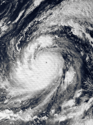
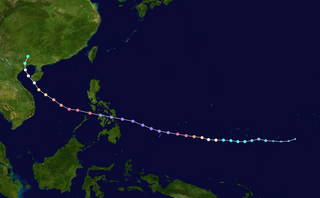
| 2013 | November 8 | Typhoon Haiyan | Tacloban, Leyte, Philippines | Category 5 super typhoon | 959.9 mbar (28.35 inHg) | Eyewall | James Reynolds, Mark Thomas | [40] |
| 2014 | July 8 | Typhoon Neoguri | Miyakojima, Okinawa, Japan | Did not make landfall | 964.8 mbar (28.49 inHg) | Outside eyewall | James Reynolds, Mark Thomas | [41] |
| 2014 | September 14–15 | Hurricane Odile | Cabo San Lucas, Baja California Sur, Mexico | Category 3 hurricane | 943.1 mbar (27.85 inHg) | Inside eye | Steve Crighton | [42] |
| 2014 | October 14 | Typhoon Vongfong | Kagoshima, Kagoshima Prefecture, Japan | Tropical storm | 975.5 mbar (28.81 inHg) | Inside center | Steve Crighton | [43] |
| 2015 | August 8 | Typhoon Soudelor | Hualien City, Hualien County, Taiwan | Category 3 typhoon | 952.8 mbar (28.14 inHg) | Inside eye | Anthony van Dyck | [44] |
| 2015 | August 23 | Typhoon Goni | Ishigaki, Okinawa, Japan | Category 3 typhoon | 944.2 mbar (27.88 inHg) | Eyewall | Solo | [45] |
| 2015 | September 28 | Typhoon Dujuan | Su'ao, Yilan, Taiwan | Category 4 typhoon | 958.3 mbar (28.30 inHg) | Inside eye | Solo | [46] |
| 2015 | October 23 | Hurricane Patricia | Emiliano Zapata, Jalisco, Mexico | Category 4 hurricane | 937.8 mbar (27.69 inHg) | Inside eye | Erik Sereno | [47] |
| 2016 | July 8 | Typhoon Nepartak | Taitung City, Taitung, Taiwan | Category 3 typhoon | 957.7 mbar (28.28 inHg) | Eyewall | Solo | [48] |
| 2016 | August 3–4 | Hurricane Earl | Belize City, Belize District, Belize | Category 1 hurricane | 982.2 mbar (29.00 inHg) | Inside eye | Solo | [49] |
| 2016 | September 1–2 | Hurricane Hermine | Hampton Springs, Florida, United States | Category 1 hurricane | 986.2 mbar (29.12 inHg) | Inside eye | Solo | [50] |
| 2016 | September 5–6 | Hurricane Newton | Cabo San Lucas, Baja California Sur, Mexico | Category 1 hurricane | 984.3 mbar (29.07 inHg) | Inside eye | Solo | [51] |
| 2016 | September 27 | Typhoon Megi | Hualien City, Hualien County, Taiwan | Category 3 typhoon | 949.2 mbar (28.03 inHg) | Inside eye | Anthony van Dyck | [52] |
| 2016 | October 6 | Hurricane Matthew | Nassau, New Providence, Bahamas | Category 4 hurricane | 977.8 mbar (28.87 inHg) | Outside eyewall | Solo | [53] |
| 2016 | October 19–20 | Typhoon Haima | Tuguegarao, Cagayan, Philippines | Category 4 typhoon | 942.0 mbar (27.82 inHg) | Inside eye | Solo | [54] |
| 2017 | March 28–29 | Cyclone Debbie | Gregory River, Queensland, Australia | Category 3 cyclone | 958.7 mbar (28.31 inHg) | Inside eye | Solo | [55] |
| 2017 | August 6 | Typhoon Noru | Toi, Miyazaki, Japan | Category 1 typhoon | 977.1 mbar (28.85 inHg) | Eyewall | Solo | [56] |
| 2017 | August 9–10 | Hurricane Franklin | Vega de Alatorre, Veracruz, Mexico | Category 1 hurricane | 990.4 mbar (29.25 inHg) | Inside eye | Solo | [57] |
| 2017 | August 25–26 | Hurricane Harvey | Rockport, Texas, United States | Category 4 hurricane | 940.8 mbar (27.78 inHg) | Inside eye | Solo | [58] |
| 2017 | September 10 | Hurricane Irma | Naples, Florida, United States | Category 3 hurricane | 940.0 mbar (27.76 inHg) | Inside eye | Solo | [59] |
| 2017 | September 20 | Hurricane Maria | Palmas del Mar, Puerto Rico, United States | Category 4 hurricane | 929.4 mbar (27.45 inHg) | Eyewall | Solo | [60] |
| 2017 | October 7–8 | Hurricane Nate | Ocean Springs, Mississippi, United States | Category 1 hurricane | 985.5 mbar (29.10 inHg) | Inside eye | Solo | [61] |
| 2017 | October 22–23 | Typhoon Lan | Omaezaki, Shizuoka, Japan | Category 2 typhoon | 952.8 mbar (28.14 inHg) | Inside eye | Solo | [62] |
| 2018 | August 21 | Typhoon Soulik | Kasaricho Oaza Yo, Kagoshima, Japan | Category 2 typhoon | — | Eyewall | Caroline Menzies | [63] |
| 2018 | August 23 | Typhoon Cimaron | Muroto, Kōchi, Japan | Category 1 typhoon | 973.7 mbar (28.75 inHg) | Inside eye | Caroline Menzies | [64] |
| 2018 | September 4 | Typhoon Jebi | Mihama, Wakayama, Japan | Category 3 typhoon | 967.1 mbar (28.56 inHg) | Eyewall | Oli Sloane | [65] |
| 2018 | September 15 | Typhoon Mangkhut | Buguey, Cagayan, Philippines | Category 5 super typhoon | 942.2 mbar (27.82 inHg) | Eyewall | Oli Sloane | [66] |
| 2018 | October 10 | Hurricane Michael | Callaway, Florida, United States | Category 5 hurricane | 923.2 mbar (27.26 inHg) | Inside eye | Oli Sloane, Matt Delaloye | [67] |
| 2018 | October 23 | Hurricane Willa | Palmito del Verde, Sinaloa, Mexico | Category 3 hurricane | 968.0 mbar (28.59 inHg) | Inside eye | Erik Sereno, Caroline Menzies | [68] |
| 2018 | October 30 | Typhoon Yutu | Dilasag, Aurora, Philippines | Category 3 typhoon | 960.4 mbar (28.36 inHg) | Eyewall | Caroline Menzies, James Levelle | [69] |
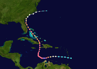
| 2019 | September 1 | Hurricane Dorian | Marsh Harbour, Abaco, Bahamas | Category 5 hurricane | 913.4 mbar (26.97 inHg) | Inside eye | Solo | [70] |
| 2019 | October 12–13 | Typhoon Hagibis | Shimoda, Shizuoka, Japan | Category 2 typhoon | 958.5 mbar (28.30 inHg) | Inside eye | Solo | [71] |
| 2019 | December 2–3 | Typhoon Kammuri | Legazpi, Albay, Philippines | Category 4 typhoon | 962.9 mbar (28.43 inHg) | Inside eye | Solo | [72] |
| 2020 | July 25 | Hurricane Hanna | Port Mansfield, Texas, United States | Category 1 hurricane | — | Inside eye | Solo | [73] |
| 2020 | August 3−4 | Hurricane Isaias | Ocean Isle Beach, North Carolina, United States | Category 1 hurricane | 990.3 mbar (29.24 inHg) | Inside eye | Solo | [74] |
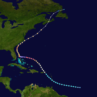
| 2020 | August 26−27 | Hurricane Laura | Sulphur, Louisiana, United States | Category 4 hurricane | 948.0 mbar (27.99 inHg) | Inside eye | Solo | [75] |
| 2020 | September 15−16 | Hurricane Sally | Gulf Shores, Alabama, United States | Category 2 hurricane | 968.2 mbar (28.59 inHg) | Inside eye | Solo | [76] |
| 2020 | October 6−7 | Hurricane Delta | Cancún, Quintana Roo, Mexico | Category 2 hurricane | — | Inside eye | Solo | [77] |
| October 9 | Estherwood, Louisiana, United States | 975.9 mbar (28.82 inHg) | Inside eye | Solo | [78] | |||
| 2020 | October 26−27 | Hurricane Zeta | Akumal, Quintana Roo, Mexico | Category 1 hurricane | 979.2 mbar (28.92 inHg) | Inside eye | Solo | [79] |
| October 28 | Bay St. Louis, Mississippi, United States | Category 2 hurricane | 979.6 mbar (28.93 inHg) | Eyewall | Solo | [80] | ||
| 2021 | August 16 | Tropical Storm Fred | Apalachicola, Florida, United States | Tropical storm | — | Inside eye | Solo | [81] |
| 2021 | August 19 | Hurricane Grace | Tulum, Quintana Roo, Mexico | Category 1 hurricane | 978.4 mbar (28.89 inHg) | Inside eye | Erik Sereno | [82] |
| August 20–21 | La Guadalupe/El Encanto, Veracruz, Mexico | Category 3 hurricane | 981.4 mbar (28.98 inHg) | Inside eye | Erik Sereno | [83] [84] | ||
| 2021 | August 29 | Hurricane Ida | Houma, Louisiana, United States | Category 4 hurricane | 966.6 mbar (28.54 inHg) | Eyewall | Chris Jackson | [85] |
| 2021 | September 9 | Hurricane Olaf | San José del Cabo, Baja California Sur, Mexico | Category 2 hurricane | 976.7 mbar (28.84 inHg) | Inside eye | Solo | [86] |
| 2021 | October 13 | Hurricane Pamela | Mármol de Salcido, Sinaloa, Mexico | Category 1 hurricane | 990.8 mbar (29.26 inHg) | Inside eye | Erik Sereno | [87] |
| 2021 | October 25 | Hurricane Rick | Ixtapa, Guerrero, Mexico | Category 2 hurricane | 1,001.5 mbar (29.57 inHg) | Eyewall | Nicola Rustichelli | [88] |
| 2022 | May 30 | Hurricane Agatha | Mazunte, Oaxaca, Mexico | Category 2 hurricane | 978.9 mbar (28.91 inHg) | Eyewall | Erik Sereno | [89] |
| 2022 | September 19 | Hurricane Fiona | Boca de Yuma, La Altagracia, Dominican Republic | Category 1 hurricane | 979.9 mbar (28.94 inHg) | Inside eye | Solo | [90] [91] |
| September 24 | Glace Bay, Nova Scotia, Canada | Category 2 post-tropical cyclone | 937.3 mbar (27.68 inHg) | Center | Solo | [92] [93] | ||
| 2022 | September 28 | Hurricane Ian | Punta Gorda, Florida, United States | Category 4 hurricane | 951.2 mbar (28.09 inHg) | Inside eye | Erik Fox | [92] [94] |
| September 30 | McClellanville/Georgetown/Garden City, South Carolina, United States | Category 1 hurricane | 979 mbar (28.9 inHg) | Inside eye | Erik Fox | [95] [96] | ||
| 2022 | October 3 | Hurricane Orlene | Caimanero, Sinaloa, Mexico | Category 1 hurricane | 991.3 mbar (29.27 inHg) | Inside eye | Erik Sereno | [97] |
| 2022 | October 23 | Hurricane Roslyn | Santa Cruz, Nayarit, Mexico | Category 3 hurricane | 962.4 mbar (28.42 inHg) | Inside eye | Erik Sereno | [98] [99] |
| 2022 | November 2 | Hurricane Lisa | Belize City, Belize District, Belize | Category 1 hurricane | 986.9 mbar (29.14 inHg) | Inside eye | Solo | [100] [101] |
| 2022 | November 9−10 | Hurricane Nicole | Stuart/Jensen Beach/Vero Beach, Florida, United States | Category 1 hurricane | 985.6 mbar (29.10 inHg) | Inside eye | Kevin Conrad | [102] [103] [104] |
| 2023 | August 30 | Hurricane Idalia | Perry/Athena, Florida, United States | Category 3 hurricane | 954.7 mbar (28.19 inHg) | Inside eye | Erik Fox, Parker Sigg | [105] [106] |
| 2023 | September 23 | Tropical Storm Ophelia | Atlantic Beach/New Bern, North Carolina, United States | Tropical storm | — | Inside eye | Solo | [107] [108] |
| 2023 | October 5 | Typhoon Koinu | Kenting, Pingtung, Taiwan | Category 4 typhoon | — | Inside eye | Anthony van Dyck | [109] |
| 2023 | October 10 | Hurricane Lidia | El Habal, Jalisco, Mexico | Category 4 hurricane | — | Eyewall | Erik Sereno | [110] |
2013 Typhoon Haiyan

On November 7, 2013, Morgerman flew with fellow chasers James Reynolds and Mark Thomas to Tacloban City in the Philippines to intercept one of the most powerful typhoons in the 21st century: Typhoon Haiyan.
They initially planned to ride out the storm south of the city, where the eye would ultimately make landfall; however, owing to a lack of sturdy shelters they opted to stay in Tacloban itself. [8] They set up at a four-story concrete hotel about 26 ft (7.9 m) above sea level. [8] [111] The chasers came prepared with a week's-worth of food and water. Around 6:45 a.m. local time, the northern eyewall began battering Tacloban and winds rapidly became violent. Morgerman described the winds to have a "tornado-like quality" at times. Windows and doors at the hotel blew out and the roof was torn off. Trees in the region were completely defoliated. Around 7:50 a.m. a powerful storm surge swept through the city, with flood waters reaching a depth of 4 ft (1.2 m) at Morgerman's location.
The fast-rising nature of the water incited panic, residents sheltering at the hotel scrambled to the building's second floor and some broke windows to escape their rooms. Morgerman jumped into the water to help people get from flooding rooms to the stairs. Thomas severely injured his leg in the water while assisting trapped people. [8]
Morgerman described the experience as traumatizing, witnessing the total devastation of Tacloban, bodies strewn across the streets, and "a city spiraling out of control". [8] The crew was stuck in Tacloban for three days, eventually "escaping" on November 10 by which time the Philippine military arrived with relief supplies. [111] Morgerman observed a minimum pressure of 959.9 mbar (28.35 inHg) in the eyewall of Haiyan. Extrapolating from his second measurement of 960.4 mbar (28.36 inHg), he estimated the central pressure to have been below 900 mbar (27 inHg). [40]
On November 5, 2023, Morgerman returned to the Philippines and met with Reynolds and Thomas in Tacloban City a day later to commemorate the 10th anniversary of the cyclone hitting the city. [112] They returned to the hotel that they rode the storm out in, and the hotel celebrated their return with a banner welcoming them back to the city. [113] Morgerman revisited locations that were memorable to him from his time chasing Haiyan and reviewed the city's recovery since then. [114] He also visited a burial site where hundreds of unidentified bodies were buried following the storm. [115] The trio also attended a commemoration ceremony at the Tacloban City Convention Center for the cyclone's victims and met with locals who remembered them from their time in the city, and later attended a lunch banquet with President Bongbong Marcos. [116] They also planted mangroves on an island the San Juanico Strait to "replace the ones lost in Haiyan". [117] Morgerman also visited a family who he had met during the storm and whom he had helped rescue their eldest daughter out of the water. [118]
2014 Hurricane Odile
In September 2014, Morgerman intercepted Hurricane Odile in Cabo San Lucas, Mexico. Successfully entering the eye, he recorded a pressure of 943.1 mbar (27.85 inHg). [42] Operational assessments of the hurricane's landfall intensity were taken into account for the release of catastrophe bonds funded by Wall Street and the World Bank. The bond system guaranteed a payout of $50 million for a storm with a pressure under 932 mbar (27.5 inHg); Odile's operational estimate was 930 mbar (27 inHg). However, his observations "upend[ed] the system" and the bonds were rescinded. This prevented vital recovery funds from being provided to the Government of Mexico. [119] The hurricane caused extensive damage throughout Baja California Sur, with insured losses estimated at $1.2 billion. [120] Industry experts later expressed concern over possible conflicts of interest with storm chasers and the catastrophe bonds. [119] [120]
2019 Hurricane Dorian

On August 31, 2019, Morgerman flew to Marsh Harbour, in the Bahamas to intercept Category 5 Hurricane Dorian. [121] Initially staging his chase in Treasure Cay, he ultimate chose to ride out the storm at Central Abaco Primary School—a designated concrete shelter—in Marsh Harbour. [122] [123] At 11:40 a.m. EDT on September 1, Morgerman reported board to be flying off the structures windows and children being wrapped in blankets for safety. [124] After tweeting this information, contact with Morgerman lost for two days before he was able to contact the Weather Channel. [122]
Around 2:00 p.m. EDT, Hurricane Dorian made landfall over the Abaco Islands with maximum sustained winds of 185 miles per hour (298 km/h), making it the strongest such storm on record in the Bahamas. [125] The eyewall of Dorian proved exceptionally violent, battering the school with "the force of a thousand sledgehammers". [126] He and others sheltering at the school held furniture against window shutters to prevent them from blowing in. [127] The school was largely destroyed in the first half of the hurricane, forcing Morgerman and those sheltering inside to evacuate to a sturdier government building during the calm of the eye. [122] During the eye, he recorded a pressure of 913.4 mbar (26.97 inHg), the lowest in his career. [70] Hundreds of residents, many injured during the storm, sought refuge in the structure for the second half of the hurricane. [122] After living in his car for two days, Morgerman arrived in Nassau by helicopter on September 3 before returning to the United States. He described Dorian as a "nuclear-grade hurricane" and "the most intense cyclone I’ve witnessed in 28 years of chasing". [122] [127]