Tropical Storm Fred (2021)

Last updated

Map key
  Tropical depression (≤38 mph, ≤62 km/h)
  Tropical storm (39–73 mph, 63–118 km/h)
  Category 1 (74–95 mph, 119–153 km/h)
  Category 2 (96–110 mph, 154–177 km/h)
  Category 3 (111–129 mph, 178–208 km/h)
  Category 4 (130–156 mph, 209–251 km/h)
  Category 5 (≥157 mph, ≥252 km/h)
  Unknown
Storm type
Disc Plain black.svg Tropical cyclone
Solid black.svg Subtropical cyclone
ArrowUp.svg Extratropical cyclone, remnant low, tropical disturbance, or monsoon depression

On August 4 at 12:00 UTC, the National Hurricane Center (NHC) noted a tropical wave which had formed in the central Atlantic. [2] Initially not deemed likely to develop, the wave's chances of development were raised on August 8 as it approached the Leeward Islands. [3] As thunderstorm activity began to consolidate, the disturbance proceeded to receive the designation as Potential Tropical Cyclone Six as it approached closer to the Leeward Islands at August 9 at 21:00 UTC, the classification "potential tropical cyclone" used by the NHC indicating a storm not yet a tropical cyclone but a land threat requiring issuance of forecasts. [4] The disturbance passed just south of Dominica, or 55 miles (89 km) south of Guadeloupe early on August 10, entering the Northeastern Caribbean Sea at around 09:00 UTC that day. [5] Despite having a well-organized appearance on satellite imagery resembling a cyclone at tropical storm strength, surface observations and data from a NOAA Hurricane Hunter aircraft flown into the disturbance earlier in the day confirmed the storm had not yet acquired a well-defined closed circulation. [6] Passing south of the Virgin Islands, radar imagery continued to affirm that the disturbance had not yet formed into a tropical cyclone with multiple areas of rotation being evident and not resembling a well-defined circulation. [7] However, following yet another hurricane hunter reconnaissance flight into the disturbance, data confirmed it was defined enough to be designated Tropical Storm Fred45 miles (72 km) south of Ponce, Puerto Rico on August 11 at 03:00 UTC. [8]

Tropical Storm Fred making landfall in the Dominican Republic on August 11 Fred 2021-08-11 1730Z.jpg
Tropical Storm Fred making landfall in the Dominican Republic on August 11

Fred's circulation continued to become better defined as reconnaissance aircraft data further confirmed the storm had intensified slightly with winds at 45 mph (72 km/h). Shortly after, Fred made landfall just west of Santo Domingo in the Dominican Republic at around 18:00 UTC that day. [9] Fred's circulation was quickly disrupted by the mountainous terrain of the island of Hispaniola, weakening to a tropical depression over the central part of the island early on August 12. [10] After emerging back over the waters north of the Windward Passage at 09:00 UTC, Fred had lost a majority of its thunderstorm activity over the center which itself had become broad and ill-defined, further exacerbated by 20 knots of westerly wind shear inflicted by an upper-level trough near Florida. [11] As Fred slowly drifted west-northwestward, continued unfavorable conditions led to Fred struggling to re-organize, with its mid-level and low-level centers being displaced around 50 miles (80 km) from each other according to reconnaissance aircraft data. [12] Fred shifted almost due westward and its low-level center moved inland over northern Cuba around 18:00 UTC on August 14. [13] Jogging a little further west than forecasted, continued land interaction with Cuba and wind shear caused Fred to degenerate into a tropical wave at 15:00 UTC on August 14, although advisories continued due to a potential land threat to Florida and the possibility of regeneration. [14]

The remnants of Fred turned northward into the Gulf of Mexico and began to re-organize, attaining gale-force winds and an organized band of thunderstorms to the east of its trough axis. [15] Furthermore, hurricane hunter reconnaissance data confirmed that the remnants had developed an organized circulation and that Fred had regenerated into a tropical storm at 12:40 UTC on August 15. [16] A lopsided tropical cyclone, most of the strongest winds were displaced to the east of the partially exposed center as the storm increased in strength once more. [17] Fred continued intensifying in a marginally favorable environment with 30 °C (86 °F) sea surface temperatures and a relatively moist atmosphere, with bursts of convection forming into a small central dense overcast over the center which was slightly more east than depicted as confirmed by reconnaissance aircraft. [18] Fred reached its peak intensity as a strong tropical storm with winds of 65 mph (105 km/h) at 18:00 UTC on August 16 shortly before making landfall a few miles southeast of Mexico Beach near Cape San Blas, Florida at a similar intensity around an hour later at 19:15 UTC. [19] [20] Fred rapidly weakened shortly after landfall, weakening to a tropical depression over Georgia by 09:00 UTC the next day. [21]

Preparations and impact

Caribbean

Fred caused $10 million in damage in the Caribbean. [22]

Lesser Antilles

Potential Tropical Cyclone Six approaching Puerto Rico on August 10. 06L 2021-08-10 1422Z-1922Z.gif
Potential Tropical Cyclone Six approaching Puerto Rico on August 10.

In Guadeloupe, Météo-France raised yellow wind alerts as the precursor disturbance to Fred approached the island country. [23] Martinique also received the same alert and reported gusty winds and rainfall as the wave passed just to the north of the island. [24]

Tropical storm watches were also issued across Dominica and Barbados and the previously mentioned islands with the designation of Potential Tropical Cyclone Six. [25]

Puerto Rico

With the designation of Potential Tropical Cyclone Six moving towards Puerto Rico, tropical storm warnings were raised on August 9. [26] By the next day, following the formation of Fred, heavy rain from the storm's outer rainbands produced heavy rainfall and brief but intense squalls which knocked out power to over 13,000 people in parts of the island. [27] [28] Governor Pedro Pierluisi noted that some gas stations shut down as large amounts of people came to fuel prior to the storm. [28] Eight shelters were also opened on the island, although only seven people sought refuge. [28] A 55 km/h (34 mph) wind gust was recorded in Lajas. [29]

Hispaniola

In the Dominican Republic, tropical storm warnings were issued as Fred approached the island on August 10. [26] Upon landfall near Santo Domingo, 400,000 people lost power across the country. [30] Flooded rivers causing the shutdown the country's aqueduct system caused more than 500,000 people to lose access to water. [31] [30] In Santo Domingo, 1,700 people were evacuated and at least 100 homes were damaged. [30] More than 47 communities were cut off and 4,025 people were displaced by flash flooding caused by the storm, while 805 homes in total were damaged across the country; at least 5 were entirely destroyed. [32] 47 flights were cancelled or delayed at Las Américas International Airport and La Isabela International Airport. [33] Social media reported street closures and the collapse of a bridge in Santo Domingo. [33]

In Haiti, the Civil Protection Unit issued a yellow level of vigilance (risk of impact at low to moderate intensity) as Fred crossed into the country. [34] The Directorate for Civil Protection reminded civilians to be cautious of floods and mudslides. [34]

United States

Fred caused a total of $1.1 billion in economic losses in the U.S. [22]

Florida

Tropical Storm Fred making landfall in Cape San Blas, Florida. KTLH loop of TS Fred landfall.gif
Tropical Storm Fred making landfall in Cape San Blas, Florida.

On August 15, tropical storm watches were issued for the majority of the Florida Panhandle as the remnants of Fred drifted northward. [35] As Fred regenerated and approached the state, the prior watches were upgraded to tropical storm warnings. [36] Franklin County officials issued an voluntary evacuation order later that same day. [37] Bay County officials warned residents to prepare for flooding rainfall events. [38] Fort Pickens was shut down on August 14 at 8:00 p.m. due to the approaching storm. [39]

Following landfall, more than 36,000 people in Florida reportedly lost electricity. [40] Schools in Bay County, Okaloosa County, and Santa Rosa County were immediately closed. [40] 7 inches (180 mm) of rain fell in Panama City within 24 hours, while 9 inches (229 mm) of rain reportedly fell in Southport, where serious flooding was evident. [41] [42] Several water rescues were carried out across Panama City, where many were rescued from their flooded homes, with no injuries reported. [43] Also in Panana City, a downed power line fell on top of a car with a man inside, trapping the man until he was rescued and hospitalized with a broken neck. [43] U.S. President Joe Biden approved the issuance of a state of emergency for 23 counties in the state soon after landfall. [44] [45] Fred brought storm surge flooding across St. George Island, Cape San Blas, and Port St. Joe, while the road to Indian Pass was blocked after being covered with over 5 feet of water [46] The bridge to St. George Island was closed shortly after wind gusts at or near hurricane-force battered the island. [46] A man in Bay County died after hydroplaning on a flooded road and falling into a ditch. [47]

Georgia

Tropical Depression Fred just east of Atlanta on August 17 Fred 2021-08-17 1903Z.jpg
Tropical Depression Fred just east of Atlanta on August 17

As Fred continued to move inland, tornado watches were issued by the National Weather Service for much of Georgia, South Carolina, and North Carolina. [48] There were 16 reports of tornadoes across the three states, while at least six of them were observed across Georgia, including but not limited to an EF1 tornado which touched down in Americus and damaged at least 100 homes and an apartment complex. [49] [50] An unconfirmed tornado hit Jeffersonville and ripped the roof off of a sports goods warehouse, while an EF1 tornado also destroyed a mobile home in Banks County northeast of Atlanta. [49] [51] A horse stable in Homer was destroyed by the same tornado, with the horses being rescued. [43] Metro Atlanta received around 2 inches (51 mm) of rain in hours. [52] A large tree was uprooted and fell on top of a home and hit a gas line in Atlanta, causing Georgia Power crews, Atlanta Gas Light crews and firefighters to rush to the scene. [53] Atlanta recorded nearly 3 inches of rain overnight, a record amount of rainfall for mid-August. [54] Major flooding hit areas along Interstate 85 in Georgia. [54]

North Carolina and South Carolina

Around 39,200 users of Duke Energy in the Carolinas lost electricity as trees across the state were knocked down while Fred moved north. [55] Even before Fred, some areas had as much as six inches of rain in three days, so the ground was saturated. [56] Fred caused record-breaking flooding in some portions of western North Carolina, with Asheville receiving over 10 inches (250 mm) of rain in a 48-hour period, leading to the issuance of a flash flood emergency. [57] [58] Residents in the nearby town of Swannanoa were asked to shelter-in-place due to the flash flooding. [58] Among the worst-hit areas, some homes were completely destroyed and several roads and bridges washed out. [59] River water levels were estimated to have swelled anywhere from 3 to 7 feet (0.9 to 2.1 m) higher than usual. [60] Mudslides blocked portions of Interstate 40 in Haywood County as well as other roads across western North Carolina. [61] Weather radar estimated that 10 to 12 inches of rain fell over the Pisgah National Forest area; nearby, in Cruso, 9.13 inches of rain was recorded within 24 hours. [43] Buncombe County recorded its worst two-day rainfall event in 50 years from August 16–17. [62] North Carolina Emergency Management deployed water rescue teams, while National Guard and Highway Patrol helicopters began searches around the same time. [63] Over 200 search and rescue personnel went house-to-house checking for survivors along the Pigeon River. [62] Several homes were ripped off their foundations and destroyed, a sheriff from the Haywood Counfy Sheriff Department noted. [62] The Pigeon River swelled 19.6 feet (6.0 meters) higher than usual and suffered its worst flooding recorded, higher than the floods caused by Hurricane Ivan in 2004. [64] [65] Central Haywood High School was deemed inoperable after flooding, forcing students to revert to remote learning. [64] In Cruso, North Carolina, 6 people died due to severe flooding in the region, the final missing individual's body being recovered on August 27. [66] [67] According to Haywood County Board of Commissioners chair Kevin Ensley, the community had $300 million in damage with 225 structures destroyed; Clyde had $18 million in damage. 687 homes in the county had some damage, and 20 NC DOT bridges were damaged and three destroyed. [68] Pisgah High School in Canton had significant damage to its athletic fields, especially the football stadium, and had to play home football games elsewhere. [69] Overall, US$11 million in damages was calculated in Transylvania County. [70]

A tornado was observed near the Hiddenite-Stony Point, North Carolina area. [55] Another tornado was reported in Iredell County, North Carolina near Statesville. [55] A funnel cloud was spotted near Drexel, North Carolina where power was reported to be out in the nearby town of Valdese. [55] A confirmed tornado also hit Lake Murray, South Carolina, downing power lines and trees. [71] Governor Roy Cooper issued a state of emergency for North Carolina on August 18. [72]

The Greenville, South Carolina area experienced a record number of tornado warnings on August 17. Thirty-six warnings were issued on that day. [73]

Northeast

The remnants of Fred spawned six tornadoes in Pennsylvania. An EF1 tornado touched down in Tilden Township in Berks County around 9 p.m. on August 18. At about 12:30 am on August 19, an EF1 tornado touched down from Souderton in Montgomery County to the area of Silverdale and Perkasie in Bucks County. [74] [75] Three more weak tornadoes touched down in New Jersey, Connecticut, and Massachusetts. [76] [77] Unrelated to tornadoes, parts of the Lehigh Valley saw over 4 inches (100 mm) of rain, [78] while Syracuse, New York recorded 4.90 inches (124 mm) of rain. [79] Flooding in northern Pennsylvania forced the Leonard Harrison State Park to temporarily close following the storm. [80] Heavy rain in Steuben County, New York triggered a flash flood emergency to be issued, requiring over 100 people to be rescued. [81] Over 2,000 customers lost power in Connecticut. [82]

See also

Related Research Articles

<span class="mw-page-title-main">Tropical Storm Fay (2008)</span> Atlantic tropical storm in 2008

Tropical Storm Fay was an unusual tropical storm that moved erratically across the state of Florida and the Caribbean Sea. The sixth named storm of the 2008 Atlantic hurricane season, Fay formed from a vigorous tropical wave on August 15 over the Dominican Republic. It passed over the island of Hispaniola, into the Gulf of Gonâve, across the island of Cuba, and made landfall on the Florida Keys late in the afternoon of August 18 before veering into the Gulf of Mexico. It again made landfall near Naples, Florida, in the early hours of August 19 and progressed northeast through the Florida peninsula, emerging into the Atlantic Ocean near Melbourne on August 20. Extensive flooding took place in parts of Florida as a result of its slow movement. On August 21, it made landfall again near New Smyrna Beach, Florida, moving due west across the Panhandle, crossing Gainesville and Panama City, Florida. As it zigzagged from water to land, it became the first storm in recorded history to make landfall in Florida four times. Thirty-six deaths were blamed on Fay. The storm also resulted in one of the most prolific tropical cyclone related tornado outbreaks on record. A total of 81 tornadoes touched down across five states, three of which were rated as EF2. Fay would cause around $560 million in damages throughout its lifespan.

<span class="mw-page-title-main">Potential Tropical Cyclone Ten</span> Tenth designated tropical disturbance during the 2017 Atlantic hurricane season

Potential Tropical Cyclone Ten was a damaging storm that was the tenth tropical disturbance designated by the National Hurricane Center (NHC) during the 2017 Atlantic hurricane season. The disturbance was deemed to have a very high chance of becoming a tropical cyclone while posing a threat to populated areas and was designated a "Potential Tropical Cyclone". The storm caused flooding and brought tropical storm-force winds to parts of the Southeastern United States and the Mid-Atlantic states, particularly Florida and the Carolinas, before going on to affect parts of Atlantic Canada. Potential Tropical Cyclone Ten was the tenth storm that had advisories issued on it by the NHC in 2017, and the only such system that failed to fully develop into a tropical cyclone during that Atlantic hurricane season. Potential Tropical Cyclone Ten originated from a tropical wave that moved off the coast of West Africa on August 13. The disturbance slowly tracked its way westward across the Atlantic Ocean, before reaching Florida in late August. The disturbance came close to developing into a tropical storm while it was situated off the coast of the Carolinas; however, strong wind shear and outflow from Hurricane Harvey prevented the storm from organizing into a tropical cyclone. The system transitioned into an extratropical cyclone instead, and became a strong hurricane-force low to the south of Newfoundland, before being absorbed by another extratropical system near Iceland on September 3.

<span class="mw-page-title-main">2021 Atlantic hurricane season</span> Hurricane season in the Atlantic Ocean

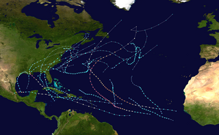
The 2021 Atlantic hurricane season was the third-most active Atlantic hurricane season on record in terms of number of tropical cyclones, although many of them were weak and short-lived. With 21 named storms forming, it became the second season in a row and third overall in which the designated 21-name list of storm names was exhausted. Seven of those storms strengthened into a hurricane, four of which reached major hurricane intensity, which is slightly above-average. The season officially began on June 1 and ended on November 30. These dates historically describe the period in each year when most Atlantic tropical cyclones form. However, subtropical or tropical cyclogenesis is possible at any time of the year, as demonstrated by the development of Tropical Storm Ana on May 22, making this the seventh consecutive year in which a storm developed outside of the official season.

<span class="mw-page-title-main">2021 Pacific hurricane season</span> Hurricane season in the Pacific Ocean

The 2021 Pacific hurricane season was a moderately active Pacific hurricane season, with above-average activity in terms of number of named storms, but below-average activity in terms of major hurricanes, as 19 named storms, 8 hurricanes, and 2 major hurricanes formed in all. It also had a near-normal accumulated cyclone energy (ACE). The season officially began on May 15, 2021 in the Eastern Pacific Ocean, and on June 1, 2021, in the Central Pacific in the Northern Hemisphere. The season ended in both regions on November 30, 2021. These dates historically describe the period each year when most tropical cyclogenesis occurs in these regions of the Pacific and are adopted by convention. However, the formation of tropical cyclones is possible at any time of the year, as illustrated by the formation of Tropical Storm Andres on May 9, which was the earliest forming tropical storm on record in the Eastern Pacific. Conversely, 2021 was the second consecutive season in which no tropical cyclones formed in the Central Pacific.

<span class="mw-page-title-main">Tropical Storm Imelda</span> Atlantic tropical storm in 2019

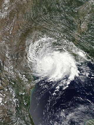
Tropical Storm Imelda was a tropical cyclone which was the fourth-wettest storm on record in the U.S. state of Texas, causing devastating and record-breaking floods in southeast Texas. The eleventh tropical cyclone and ninth named storm of the 2019 Atlantic hurricane season, Imelda formed out of an upper-level low that developed in the Gulf of Mexico and moved westward. Little development occurred until the system was near the Texas coastline, where it rapidly developed into a tropical storm before moving ashore shortly afterward on September 17. Imelda weakened after landfall, but continued bringing large amounts of flooding rain to Texas and Louisiana, before dissipating on September 21.

<span class="mw-page-title-main">Hurricane Lorena (2019)</span> Category 1 Pacific hurricane in 2019

Hurricane Lorena was a strong Pacific hurricane in September 2019 that brought heavy rainfall, flooding, and mudslides to Southwestern Mexico and the Baja California Peninsula and also brought severe weather to the U.S. state of Arizona. Lorena was the thirteenth named storm and seventh and final hurricane of the 2019 Pacific hurricane season. A tropical wave, originally from the North Atlantic, entered the East Pacific basin on September 16. With increasing thunderstorm development, Lorena formed as a tropical storm on September 17 alongside Tropical Storm Mario. Lorena made its passage northwestward and quickly gained strength before it made landfall as a Category 1 hurricane in Jalisco on September 19. Due to interaction with the mountainous terrain, Lorena weakened back to a tropical storm. After moving into the warm ocean temperatures of the Gulf of California, however, Lorena re-strengthened into a hurricane, and reached its peak intensity with 1-minute sustained winds of 85 mph (137 km/h) and a minimum barometric pressure of 985 millibars (29.1 inHg) Lorena made a second landfall in the Mexican state of Baja California Sur, and quickly weakened thereafter. Lorena weakened to a tropical storm over the Gulf of California, and became a remnant low on September 22, shortly after making landfall in Sonora as a tropical depression. The remnant low moved inland over Mexico, and eventually dissipated inland over Arizona on September 24.

<span class="mw-page-title-main">Tropical Storm Nestor (2019)</span> Atlantic tropical storm in 2019

Tropical Storm Nestor was a large but short-lived and disorganized tropical cyclone which caused widespread tornadoes and heavy rain in the Southeastern United States during mid-October 2019. The sixteenth depression and fourteenth named storm of the erratic 2019 Atlantic hurricane season, Nestor originated from a broad area of low pressure over the Western Caribbean. It emerged in the Gulf of Mexico and began to organize slightly, becoming Potential Tropical Cyclone Sixteen due to its threat to the Southeastern United States. It gained a sufficient enough of a circulation to be designated Tropical Storm Nestor near the Florida Panhandle early on October 18, crawling to the northeast, and then finally transitioning into an extratropical cyclone due to strong shear from a nearby upper-level low before making landfall on the Florida Panhandle on October 19.

<span class="mw-page-title-main">Tropical Storm Bertha (2020)</span> 2020 tropical storm in the North Atlantic Ocean

Tropical Storm Bertha was a rapidly forming and short-lived off-season tropical storm that affected the Eastern United States in late May 2020. The second named storm of the very active 2020 Atlantic hurricane season, Bertha originated from a trough in the Gulf of Mexico. The National Hurricane Center (NHC) only anticipated slight development as the trough moved over southern Florida, bringing torrential rainfall. The system rapidly organized on May 27 after it emerged into the western Atlantic Ocean, developing a small, well-defined circulation. That day, the disturbance developed into Tropical Storm Bertha east of Georgia, and a few hours later it moved ashore near Isle of Palms, South Carolina with peak winds of 50 mph (80 km/h). The storm weakened over land and dissipated late on May 28 over West Virginia.

<span class="mw-page-title-main">Tropical storms Amanda and Cristobal</span> East Pacific and Atlantic tropical storms in 2020

Tropical Storm Amanda and Tropical Storm Cristobal were two related, consecutive tropical storms that affected Central America, southern Mexico, the Central United States, and Canada in late May and early June 2020. The first tropical cyclone formed in the East Pacific and was named Amanda. After crossing Central America, it regenerated into a second one in the Gulf of Mexico and was named Cristobal. Amanda was the second tropical depression and the first named storm of the 2020 Pacific hurricane season, and Cristobal was the third named storm of the extremely active 2020 Atlantic hurricane season, and the earliest third named storm in the North Atlantic Ocean on record. Cristobal's regeneration date in the North Atlantic eclipsed the date set by Tropical Storm Colin in 2016, which formed on June 5. It was also the first Atlantic tropical storm formed in the month of June since Cindy in 2017, and the first June tropical cyclone to make landfall in Mexico since Danielle in 2016.

<span class="mw-page-title-main">Hurricane Dolores (2015)</span> Category 4 Pacific hurricane in 2015

Hurricane Dolores was a powerful and moderately damaging tropical cyclone whose remnants brought record-breaking heavy rains and strong winds to California. The seventh named storm, fourth hurricane, and third major hurricane of the record-breaking 2015 Pacific hurricane season, Dolores formed from a tropical wave on July 11. The system gradually strengthened, attaining hurricane status on July 13. Dolores rapidly intensified as it neared the Baja California peninsula, finally peaking as a Category 4 hurricane on the Saffir–Simpson scale with winds of 130 mph (215 km/h) on July 15. An eyewall replacement cycle began and cooler sea-surface temperatures rapidly weakened the hurricane, and Dolores weakened to a tropical storm two days later. On July 18, Dolores degenerated into a remnant low west of the Baja California peninsula.

<span class="mw-page-title-main">Hurricane Genevieve (2020)</span> Category 4 Pacific hurricane in 2020

Hurricane Genevieve was a strong tropical cyclone that almost made landfall on the Baja California Peninsula in August 2020. Genevieve was the twelfth tropical cyclone, eighth named storm, third hurricane, and second major hurricane of the 2020 Pacific hurricane season. The cyclone formed from a tropical wave that the National Hurricane Center (NHC) first started monitoring on August 10. The wave merged with a trough of low pressure on August 13, and favorable conditions allowed the wave to intensify into Tropical Depression Twelve-E at 15:00 UTC. Just six hours later, the depression became a tropical storm and was given the name Genevieve. Genevieve quickly became a hurricane by August 17, and Genevieve began explosive intensification the next day. By 12:00 UTC on August 18, Genevieve reached its peak intensity as a Category 4 hurricane, with maximum 1-minute sustained winds of 130 mph and a minimum central pressure of 950 millibars (28 inHg). Genevieve began to weaken on the next day, possibly due to cooler waters caused by Hurricane Elida earlier that month. Genevieve weakened below tropical storm status around 18:00 UTC on August 20, as it passed close to Baja California Sur. Soon afterward, Genevieve began to lose its deep convection and became a post-tropical cyclone by 21:00 UTC on August 21, eventually dissipating off the coast of Southern California late on August 24.

<span class="mw-page-title-main">Hurricane Marco (2020)</span> Category 1 Atlantic hurricane in 2020

Hurricane Marco was the first of two tropical cyclones to threaten the Gulf Coast of the United States within a three-day period. The thirteenth named storm and third hurricane of the record-breaking 2020 Atlantic hurricane season, Marco developed from a fast-moving tropical wave west of the Windward Islands and south of Jamaica on August 20. The fast motion of the wave inhibited intensification initially, but as the wave slowed down and entered a more favorable environment, the system developed into a tropical depression, which in turn rapidly intensified into a strong tropical storm. Due to strong wind shear, Marco's intensification temporarily halted. However, after entering the warm waters of the Gulf of Mexico on August 23, Marco briefly intensified into a hurricane, only to quickly weaken later that evening due to another rapid increase in wind shear. Marco subsequently weakened to a tropical depression before degenerating into a remnant low early the next morning. Marco's remnants subsequently dissipated on August 26.

<span class="mw-page-title-main">Hurricane Sally</span> Category 2 Atlantic hurricane in 2020

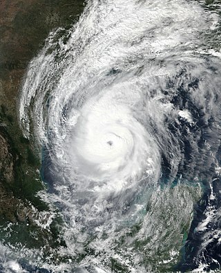
Hurricane Sally was a destructive and slow-moving Atlantic hurricane that was the first hurricane to make landfall in the U.S. state of Alabama since Ivan in 2004, coincidentally on the same date in the same place. The eighteenth named storm and seventh hurricane of the extremely active 2020 Atlantic hurricane season, Sally developed from an area of disturbed weather which was first monitored over the Bahamas on September 10. The system grew a broad area of low-pressure on September 11, and was designated as a tropical depression late that day. Early the next day, the depression made landfall at Key Biscayne and subsequently strengthened into Tropical Storm Sally that afternoon. Moderate northwesterly shear prevented significant intensification for the first two days, but convection continued to grow towards the center and Sally slowly intensified. On September 14, a center reformation into the center of the convection occurred, and data from a hurricane hunter reconnaissance aircraft showed that Sally had rapidly intensified into a strong Category 1 hurricane. However, an increase in wind shear and upwelling of colder waters halted the intensification and Sally weakened slightly on September 15 before turning slowly northeastward. Despite this increase in wind shear, it unexpectedly re-intensified, reaching Category 2 status early on September 16 before making landfall at peak intensity at 09:45 UTC on September 16, near Gulf Shores, Alabama, with maximum sustained winds of 110 mph (180 km/h) and a minimum central pressure of 965 millibars (28.5 inHg). The storm rapidly weakened after landfall before transitioning into an extratropical low at 12:00 UTC the next day. Sally's remnants lasted for another day as they moved off the coast of the Southeastern United States before being absorbed into another extratropical storm on September 18.

<span class="mw-page-title-main">Hurricane Paulette</span> Category 2 Atlantic hurricane in 2020

Hurricane Paulette was a strong and long-lived Category 2 Atlantic hurricane which became the first to make landfall in Bermuda since Hurricane Gonzalo did so in 2014. The sixteenth named storm and sixth hurricane of the record-breaking 2020 Atlantic hurricane season, Paulette developed from a tropical wave that left the coast of Africa on September 2. The wave eventually consolidated into a tropical depression on September 7. Paulette fluctuated in intensity over the next few days, due to strong wind shear, initially peaking as a strong tropical storm on September 8. It eventually strengthened into a hurricane early on September 13 as shear decreased. On September 14, Paulette made landfall in northeastern Bermuda as a Category 2 hurricane, while making a gradual turn to the northeast. The cyclone further strengthened as it moved away from the island, reaching its peak intensity with 1-minute sustained winds of 105 mph (169 km/h) and a minimum central atmospheric pressure of 965 mbar (28.5 inHg) on September 14. On the evening of September 15, Paulette began to weaken and undergo extratropical transition, which it completed on September 16. The hurricane's extratropical remnants persisted and moved southward then eastward, and eventually, Paulette regenerated into a tropical storm early on September 20 south of the Azores– which resulted in the U.S National Weather Service coining the phrase "zombie storm" to describe its unusual regeneration. Paulette's second phase proved short-lived, however, as the storm quickly weakened and became post-tropical again two days later. The remnant persisted for several days before dissipating south of the Azores on September 28. In total, Paulette was a tropical cyclone for 11.25 days, and the system had an overall lifespan of 21 days.

<span class="mw-page-title-main">Subtropical Storm Alpha (2020)</span> Atlantic subtropical storm in 2020

Subtropical Storm Alpha was the first subtropical or tropical cyclone ever observed to make landfall in mainland Portugal. The twenty-second tropical or subtropical cyclone and twenty-first named storm of the extremely active and record-breaking 2020 Atlantic hurricane season, Alpha originated from a large non-tropical low that was first monitored by the National Hurricane Center on 15 September. Initially not anticipated to transition into a tropical cyclone, the low gradually tracked south-southeastward for several days with little development. By early on 17 September, the low had separated from its frontal features and exhibited sufficient organization to be classified as a subtropical cyclone, as it approached the Iberian Peninsula, becoming a subtropical storm around that time. Alpha then made landfall just south of Figueira da Foz, Portugal during the evening of 18 September, then rapidly weakened as it moved over the mountainous terrain of Northeastern Portugal. The system degenerated into a remnant low on 19 September, when it was last noted.

<span class="mw-page-title-main">Tropical Storm Beta (2020)</span> Atlantic tropical storm in 2020

Tropical Storm Beta was a tropical cyclone that brought heavy rainfall, flooding, and severe weather to the Southeastern United States in September 2020. The twenty-third tropical depression and twenty-third named storm of the record-breaking 2020 Atlantic hurricane season, Beta originally formed from a trough of low pressure that developed in the northeastern Gulf of Mexico on September 10. The low moved slowly southwestward, with development hampered initially by the development of nearby Hurricane Sally. After Sally moved inland over the Southeastern United States and weakened, the disturbance became nearly stationary in the southwestern Gulf, where it began to organize. By September 16, the storm had gained a low-level circulation center and had enough organization to be designated as Tropical Depression Twenty-Two. The system held its intensity for a day due to the influence of strong wind shear and dry air, before eventually attaining tropical storm strength. It slowly moved northward and intensified to a mid-range tropical storm before dry air and wind shear halted its intensification. Beta then became nearly stationary on September 19, before starting to move west towards the Texas coast the next day, weakening as it approached. On September 21, Beta made landfall near Matagorda Peninsula, Texas as a minimal tropical storm. It subsequently weakened to a tropical depression the next day before becoming post-tropical early on September 23. Its remnants moved northeastward, before the center elongated and merged with a cold front early on September 25.

<span class="mw-page-title-main">Hurricane Delta</span> Category 4 Atlantic hurricane in 2020

Hurricane Delta was the record-tying fourth named storm of 2020 to make landfall in Louisiana, as well as the record-breaking tenth named storm to strike the United States in that year. The twenty-sixth tropical cyclone, twenty-fifth named storm, tenth hurricane, and third major hurricane of the record-breaking 2020 Atlantic hurricane season, Delta formed from a tropical wave which was first monitored by the National Hurricane Center (NHC) on October 1. Moving westward, the tropical wave began to quickly organize. A well-defined center of circulation formed with sufficiently organized deep convection on October 4, and was designated as Tropical Depression Twenty-six and soon thereafter, Tropical Storm Delta. Extremely rapid intensification ensued throughout October 5 into October 6, with Delta becoming a Category 4 hurricane within 28 hours of attaining tropical storm status. The rate of intensification was the fastest in the Atlantic basin since Hurricane Wilma in 2005. After peaking in intensity however, an unexpected increase in wind shear and dry air quickly weakened the small storm before it made landfall in Puerto Morelos, Mexico as a Category 2 hurricane with 105 mph (169 km/h) winds. It weakened some more over land before emerging into the Gulf of Mexico, where it was downgraded to a Category 1 hurricane. After that, it began to restrengthen, regaining Category 3 status late on October 8. It then turned northward and reached a secondary peak intensity of 953 mbar (28.14 inHg) and winds of 120 mph early on October 9. Delta then began to turn more north-northeastward into an area of cooler waters, higher wind shear, and dry air, causing it to weaken back to Category 2 status. Delta then made landfall at 23:00 UTC near Creole, Louisiana with winds of 100 mph (160 km/h) and a pressure of 970 mbar (29 inHg). The storm began to weaken more rapidly after landfall, becoming post-tropical just 22 hours later.

<span class="mw-page-title-main">Hurricane Zeta</span> Category 3 Atlantic hurricane in 2020

Hurricane Zeta was a late-season major hurricane in 2020 that made landfall on the Yucatán Peninsula and then in southeastern Louisiana, the latest on record to do so at such strength in the United States. Zeta was the record-tying sixth hurricane of the year to make landfall in the United States. The twenty-seventh named storm, twelfth hurricane and fifth major hurricane of the extremely active 2020 Atlantic hurricane season, Zeta formed from a broad area of low pressure that formed in the western Caribbean Sea on October 19. After battling wind shear, the quasi-stationary low organized into Tropical Depression Twenty-Eight on October 24. The system strengthened into Tropical Storm Zeta early on October 25 before becoming a hurricane the next day as it began to move northwestward. Hurricane Zeta made landfall on the Yucatán Peninsula late on October 26 and weakened while inland to a tropical storm, before moving off the northern coast of the peninsula on October 27. After weakening due to dry air entrainment, Zeta reorganized and became a hurricane again, and eventually a Category 2 hurricane, as it turned northeastward approaching the United States Gulf Coast on October 28. It continued to strengthen until it reached its peak intensity as a major Category 3 hurricane with 115-mile-per-hour (185 km/h) sustained winds and a minimum pressure of 970 mbar (28.64 inHg) as it made landfall at Cocodrie, Louisiana, that evening. Zeta continued on through Mississippi and parts of Alabama with hurricane-force winds. Zeta gradually weakened as it accelerated northeastward, and became post-tropical on October 29, as it moved through central Virginia, dissipating shortly afterwards off the coast of New Jersey. After bringing accumulating snow to parts of New England, the extratropical low-pressure system carrying Zeta's remnant energy impacted the United Kingdom on November 1 and 2.

<span class="mw-page-title-main">Tropical Storm Claudette (2021)</span> Atlantic tropical storm in 2021

Tropical Storm Claudette was a weak tropical cyclone that caused heavy rain and tornadoes across the Southeastern United States in June 2021, leading to severe damage. The third named storm of the 2021 Atlantic hurricane season, Claudette originated from a broad trough of low pressure over the Bay of Campeche on June 12. The disturbance moved erratically over the region for the next several days, before proceeding northward with little development due to unfavorable upper-level winds and land interaction. Despite this, the National Hurricane Center (NHC) initiated advisories on it as a Potential Tropical Cyclone late on June 17, due to its imminent threat to land. The disturbance finally organized into Tropical Storm Claudette at 00:00 UTC on June 19 just before landfall in southeast Louisiana. Claudette weakened to a depression as it turned east-northeastward before moving through Mississippi, Alabama, Georgia, and South Carolina. Baroclinic forcing then caused Claudette to reintensify into a tropical storm over North Carolina early on June 21 before it accelerated into the Atlantic Ocean later that day. Soon afterward, it degenerated into a low-pressure trough on the same day, before being absorbed into another extratropical cyclone on the next day.

<span class="mw-page-title-main">Tropical Storm Danny (2021)</span> Atlantic tropical storm in 2021

Tropical Storm Danny was a weak and short-lived tropical cyclone that caused minor damage to the U.S. states of South Carolina and Georgia. The fourth named storm of the 2021 Atlantic hurricane season, the system formed from an area of low-pressure that developed from an upper-level trough over the central Atlantic Ocean on June 22. Moving west-northwestward, the disturbance gradually developed as convection, or showers and thunderstorms, increased over it. Although it was moving over the warm Gulf Stream, the organization of the disturbance was hindered by strong upper-level wind shear. By 18:00 UTC of June 27, as satellite images showed a well-defined center and thunderstorms, the system was upgraded to a tropical depression by the National Hurricane Center (NHC). At 06:00 UTC on the next day, the system further strengthened into Tropical Storm Danny east-southeast of Charleston, South Carolina. Danny continued its track towards South Carolina while slowly strengthening, subsequently reaching its peak intensity at that day of 45 mph (72 km/h) and a minimum central pressure of 1,009 mbar (29.8 inHg) at 18:00 UTC. Danny then made landfall in Pritchards Island, north of Hilton Head, in a slightly weakened state at 23:20 UTC on the same day, with winds of 40 mph (64 km/h) and indicating that Danny weakened prior to moving inland. The system then weakened to a tropical depression over east-central Georgia, before dissipating shortly afterward.

References

  1. "Billion-Dollar Weather and Climate Disasters: Events". October 8, 2021.
  2. Stewart, Stacy (August 9, 2021). "Five-Day Graphical Tropical Weather Outlook". www.nhc.noaa.gov. Miami, Florida: National Hurricane Center. Retrieved August 9, 2021.
  3. Brown, Daniel (August 8, 2021). "Five-Day Graphical Tropical Weather Outlook". www.nhc.noaa.gov. Miami, Florida: National Hurricane Center. Retrieved August 17, 2021.
  4. Brown, Daniel; Papin, Philippe (August 9, 2021). "Potential Tropical Cyclone Six Discussion Number 1". www.nhc.noaa.gov. Miami, Florida: National Hurricane Center . Retrieved August 10, 2021.
  5. Pasch, Richard (August 10, 2021). "Potential Tropical Cyclone Six Public Advisory Number 3". www.nhc.noaa.gov. Miami, Florida: National Hurricane Center. Retrieved August 17, 2021.
  6. Beven, Jack (August 10, 2021). "Potential Tropical Cyclone Six Forecast Discussion Number 4". www.nhc.noaa.gov. Miami, Florida: National Hurricane Center. Retrieved August 17, 2021.
  7. Beven, Jack (August 10, 2021). "Potential Tropical Cyclone Six Forecast Discussion Number 4". www.nhc.noaa.gov. Miami, Florida: National Hurricane Center. Retrieved August 17, 2021.
  8. Stewart, Stacy (August 11, 2021). "Tropical Storm Fred Forecast Discussion Number 6". www.nhc.noaa.gov. Miami, Florida: National Hurricane Center. Retrieved August 17, 2021.
  9. Beven, Jack (August 11, 2021). "Tropical Storm Fred Public Advisory Number 8A". www.nhc.noaa.gov. Miami, Florida: National Hurricane Center. Retrieved August 17, 2021.
  10. Stewart, Stacy (August 12, 2021). "Tropical Depression Fred Public Advisory Number 9A". www.nhc.noaa.gov. Miami, Florida: National Hurricane Center. Retrieved August 17, 2021.
  11. Cangialosi, John (August 12, 2021). "Tropical Depression Fred Forecast Discussion Number 11". www.nhc.noaa.gov. Miami, Florida: National Hurricane Center. Retrieved August 17, 2021.
  12. Stewart, Stacy (August 13, 2021). "Tropical Depression Fred Forecast Discussion Number 14". www.nhc.noaa.gov. Miami, Florida: National Hurricane Center. Retrieved August 17, 2021.
  13. Brennan, Michael (August 12, 2021). "Tropical Depression Fred Public Advisory Number 16A". www.nhc.noaa.gov. Miami, Florida: National Hurricane Center. Retrieved August 17, 2021.
  14. Beven, Jack (August 14, 2021). "Remnants of Fred Forecast Discussion Number 20". www.nhc.noaa.gov. Miami, Florida: National Hurricane Center. Retrieved August 17, 2021.
  15. Stewart, Stacy (August 15, 2021). "Remnants of Fred Forecast Discussion Number 23". www.nhc.noaa.gov. Miami, Florida: National Hurricane Center. Retrieved August 17, 2021.
  16. Beven, Jack (August 15, 2021). "Tropical Storm Fred Tropical Cyclone Update". www.nhc.noaa.gov. Miami, Florida: National Hurricane Center. Retrieved August 17, 2021.
  17. Brown, Daniel (August 16, 2021). "Tropical Storm Fred Forecast Discussion Number 26". www.nhc.noaa.gov. Miami, Florida: National Hurricane Center. Retrieved August 17, 2021.
  18. Pasch, Richard (August 16, 2021). "Tropical Storm Fred Forecast Discussion Number 28". www.nhc.noaa.gov. Miami, Florida: National Hurricane Center. Retrieved August 17, 2021.
  19. Pasch, Richard (August 16, 2021). "Tropical Storm Fred Public Advisory Number 28A". www.nhc.noaa.gov. Miami, Florida: National Hurricane Center. Retrieved August 17, 2021.
  20. Pasch, Richard; Hagen, Andrew (August 16, 2021). "Tropical Storm Fred Tropical Cyclone Update". www.nhc.noaa.gov. Miami, Florida: National Hurricane Center. Retrieved August 17, 2021.
  21. Stewart, Stacy (August 17, 2021). "Tropical Depression Fred Public Advisory Number 31". www.nhc.noaa.gov. Miami, Florida: National Hurricane Center. Retrieved August 17, 2021.[ permanent dead link ]
  22. 1 2 Global Catastrophe Recap August 2021 (PDF) (Report). Aon Benfield. September 10, 2021. Retrieved September 10, 2021.
  23. "La zone suspecte numérotée 94L devrait traverser les petites antilles cette nuit". www.cycloneoi.com (in French). Retrieved August 17, 2021.
  24. "Une onde tropicale avec de fortes pluies orageuses et du vent passe sur la Martinique en début de soirée". Martinique la 1ère (in French). August 9, 2021. Retrieved August 17, 2021.
  25. "Tropical storm watches issued as Potential Tropical Cyclone 6 heads for Caribbean » Yale Climate Connections". Yale Climate Connections. August 9, 2021. Retrieved August 17, 2021.
  26. 1 2 "Tropical Storm Warnings Issued for Puerto Rico, Dominican Republic". NBC 6 South Florida. August 9, 2021. Retrieved August 17, 2021.
  27. "Rain pelts Puerto Rico, USVI as Tropical Storm Fred forms". AP NEWS. August 9, 2021. Retrieved August 17, 2021.
  28. 1 2 3 "Tropical Storm Fred nearing the Dominican Republic". CNBC. August 11, 2021. Retrieved August 17, 2021.
  29. National Weather Service San Juan, PR [@NWSSanJuan] (August 11, 2021). "Tropical Storm #Fred highest wind gust reports over Puerto Rico and USVI 💨 Reportes de ráfagas de viento más altas de la Tormenta Tropical #Fred sobre Puerto Rico e Islas Vírgenes Estadounidenses#prwx #usviwx" (Tweet) via Twitter.
  30. 1 2 3 "Fred leaves the Dominican Republic without electricity and heads toward Cuba". The Yucatan Times. August 13, 2021. Retrieved August 17, 2021.
  31. Coto, Dánica (August 11, 2021). "Power outages hit Dominican Republic as TS Fred weakens". www.wect.com. Retrieved August 17, 2021.
  32. Group, 2006-2020, Merit Designs Consulting. "Fred displaced thousands, cuts off towns". DominicanToday. Retrieved August 17, 2021.{{cite web}}: CS1 maint: numeric names: authors list (link)
  33. 1 2 Group, 2006-2020, Merit Designs Consulting. "Fred causes widespread damages in Dominican Republic". DominicanToday. Retrieved August 17, 2021.{{cite web}}: CS1 maint: numeric names: authors list (link)
  34. 1 2 "Fred rétrogradé en dépression tropicale, la vigilance jaune maintenue en Haïti". Le Nouvelliste. Retrieved August 17, 2021.
  35. Stewart, Stacy (August 15, 2021). "Remnants of Fred Public Advisory Number 23". www.nhc.noaa.gov. Miami, Florida: National Hurricane Center. Retrieved August 18, 2021.
  36. "Tropical Storm FRED". www.nhc.noaa.gov. Retrieved August 18, 2021.
  37. WCTV Staff (August 15, 2021). "Franklin County officials issue voluntary evacuation order for certain areas ahead of Tropical Storm Fred". www.wctv.tv. Retrieved August 18, 2021.
  38. Baker, Allison (August 16, 2021). "Bay County Officials prepare for Tropical Storm Fred". www.wjhg.com. Retrieved August 18, 2021.
  39. National Seashore Closing Fort Pickens for Severe Weather, NavarrePress, August 14, 2021
  40. 1 2 Madeline Holcombe and Travis Caldwell (August 16, 2021). "Tropical Storm Fred makes landfall in the Florida Panhandle". CNN. Retrieved August 18, 2021.
  41. "A look around the Panhandle after Tropical Storm Fred". mypanhandle.com. August 17, 2021. Retrieved August 18, 2021.
  42. "Tropical Depression Fred Is Spreading Threats of Flooding Rain and Isolated Tornadoes Into the Southeast | The Weather Channel - Articles from The Weather Channel | weather.com". The Weather Channel. Retrieved August 18, 2021.
  43. 1 2 3 4 "Raging floodwaters surge through states as Fred charges north". AccuWeather. August 18, 2021.
  44. "President Biden approves Florida Emergency Declaration". WTXL. August 17, 2021. Retrieved August 18, 2021.
  45. Rice, John Bacon and Doyle. "Tropical Storm Fred leaves thousands of Florida Pandhandle residents without power; Grace again a tropical storm". USA TODAY. Retrieved August 18, 2021.
  46. 1 2 Schneider, Jeff Burlew and Tori Lynn. "'A lot of water' but not a lot of major damage; officials say Fred a 'good reminder' to be prepared". Tallahassee Democrat. Retrieved August 18, 2021.
  47. Fleshler, Robin Webb, David (August 17, 2021). "Tropical Storm Fred caused at least one death, spawns tornadoes". dailypress.com. Retrieved August 18, 2021.{{cite web}}: CS1 maint: multiple names: authors list (link)
  48. Waldrop, Kelly McCleary and Theresa (August 17, 2021). "Tropical Depression Fred unleashing tornadoes and rain in the Southeast". CNN. Retrieved August 18, 2021.
  49. 1 2 NWS Damage Survey for the 08/17/2021 Tornado Event from the Remnants of Fred (Report). Iowa Environmental Mesonet. National Weather Service Weather Forecast Office in Peachtree City, Georgia. August 18, 2021. Retrieved August 18, 2021.
  50. "Flooding, Tornadoes Damage Homes and Shut Down Roads in Georgia, Carolinas as Fred's Remnants Move Through | The Weather Channel - Articles from The Weather Channel | weather.com". The Weather Channel. Retrieved August 18, 2021.
  51. Bryan Anderson (August 17, 2021). "Wet and unwelcome, Fred spawns twisters and flooding in US". www.wafb.com. Retrieved August 18, 2021.
  52. Beesley, Ryan (August 15, 2021). "Fred brings damage, flooding to north Georgia". FOX 5 Atlanta. Retrieved August 18, 2021.
  53. "Storms leave behind damage across parts of Georgia as Fred moves out". WSB-TV Channel 2 - Atlanta. August 18, 2021. Retrieved August 18, 2021.
  54. 1 2 "Tornadoes, flooding reported as Fred moved through Georgia". 11Alive.com. August 17, 2021. Retrieved August 18, 2021.
  55. 1 2 3 4 "What's left of Fred spawns tornadoes, cuts power to thousands in Charlotte, Carolinas". Charlotte Observer. August 17, 2021.
  56. Boyle, John (September 9, 2021). "Mountain flooding: 'Dams' and 'wall of water effect': Haywood County sees extensive damage". Asheville Citizen-Times.
  57. "Western NC starts to repair damaged homes, hearts as 2 dead and 20 still missing from flooding". August 17, 2021.
  58. 1 2 Miller, Ryan W. "Storm tracker: At least 35 missing after Fred sweeps North Carolina; Hurricane Grace forms as Henri eyes New England". USA TODAY. Retrieved August 19, 2021.
  59. Price, Mark (August 18, 2021). "20 people missing, bridges and roads washed out in parts of western North Carolina". Charlotte Observer. Retrieved July 28, 2023.
  60. "30 people missing, bridges and roads washed out in parts of western North Carolina". Charlotte Observer.
  61. "Landslides close lanes of Interstate-40 outside Asheville, other roadways in western NC". August 17, 2021.
  62. 1 2 3 Harris, Ryan W. Miller and Shelby. "2 dead, 20 missing after severe flooding in North Carolina; tornado warnings issued in New York: Latest on storm Fred". USA TODAY. Retrieved August 19, 2021.
  63. "North Carolina Gov. Cooper Issues State of Emergency After Tropical Storm Fred Causes Historic Flooding". Insurance Journal. August 18, 2021. Retrieved August 18, 2021.
  64. 1 2 Hyatt, Vicki (August 20, 2021). "Haywood floods of 2021 worse than '04". The Mountaineer. Retrieved August 23, 2021.
  65. "Extreme flooding leaves 2 dead, 20 unaccounted for in North Carolina". Washington Post. ISSN   0190-8286 . Retrieved August 23, 2021.
  66. "Final victim of Tropical Storm Fred recovered in WNC, officials say". WYFF. August 28, 2021. Retrieved August 28, 2021.
  67. Chávez, Karen. "Fifth victim identified in Tropical Depression Fred flooding in Haywood County". The Asheville Citizen Times. Retrieved August 22, 2021.
  68. Harris, Shelby (September 8, 2021). "Tropical Depression Fred's sweep over WNC declared federal disaster; FEMA aid coming". Asheville Citizen-Times . Retrieved September 9, 2021.
  69. Crabtree-Hannigan, James (October 21, 2021). "Carolina Panthers donating $50,000 to Pisgah and Rosman high schools to aid flood recovery". Asheville Citizen-Times.
  70. "With damages already over $11 million, Transylvania County comes together". wlos.com. August 19, 2021. Retrieved August 19, 2021.
  71. "Tornado touchdown confirmed near Lake Murray". wltx.com. August 17, 2021. Retrieved August 18, 2021.
  72. "30 missing, 98 rescued after Tropical Storm Fred brings flooding in North Carolina now under a State of Emergency". wfmynews2.com. August 18, 2021. Retrieved August 18, 2021.
  73. Tornadoes touch down in Upstate South Carolina leaving damage, flooding, Chris Justus says, WYFF4, August 18, 2021
  74. Mayer, Keith (August 19, 2021). "Tornado touched down in Berks, National Weather Service says". Reading Eagle. Archived from the original on August 20, 2021. Retrieved August 19, 2021.
  75. Staff; Solis, George (August 19, 2021). "National Weather Service confirms tornadoes in Montgomery, Bucks, Berks counties". Philadelphia, PA: WPVI-TV. Retrieved August 19, 2021.
  76. Three Confirmed Tornadoes (Report). Iowa Environmental Mesonet. National Weather Service Weather Forecast Office in Mount Holly, New Jersey. August 20, 2021. Retrieved August 20, 2021.
  77. NWS Confirms Two Tornadoes on August 19 2021 from the Remnants of Fred (Report). Iowa Environmental Mesonet. National Weather Service Weather Forecast Office in Boston/Norton Massachusetts. August 20, 2021. Retrieved August 20, 2021.
  78. "How much rain fell from the remnants of Tropical Storm Fred, and is more on the way in the Lehigh Valley?". August 19, 2021.
  79. Teske, Jim (August 18, 2022). "Last Friday marks one year since flooding from 'Fred'". Localsyr. Retrieved November 17, 2022.
  80. Leonard Harrison State Park & Pine Creek Rail Trail closed due to flooding, MyTwiners, August 20, 2021
  81. Two Tropical Systems in a Week, Northeast Regional Climate Center
  82. Connecticut weather in 2021: Tropical storms, tornadoes and flash flooding, CTInsider, January 3, 2022

Commons-logo.svg Media related to Tropical Storm Fred (2021) at Wikimedia Commons

Tropical Storm Fred
Fred 2021-08-16 1620Z.jpg
Tropical Storm Fred nearing landfall in the Florida Panhandle on August 16