Tutong District or simply Tutong is one of the four districts of Brunei. It has an area of 1,166 square kilometres (450 sq mi); the population was 48,313 in 2016. The administrative town is Pekan Tutong. It is home to Tasek Merimbun, the country's largest natural lake.
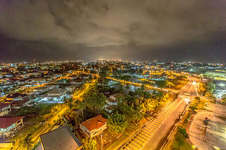
Kuala Belait is the administrative town of Belait District, Brunei. The population of the town proper was 4,259 in 2016. Kuala Belait is officially a municipal area, as well as a village under the mukim of the same name. The town is located 85 kilometres (53 mi) west of the country's capital Bandar Seri Begawan, and 20 kilometres (12 mi) west of Seria, the district's other town. It is also in the westernmost part of country, near the mouth of the Belait River.
Tutong or officially known as Tutong Town is a municipality town in Mukim Pekan Tutong Tutong District, Brunei. It is located about 40 kilometres (25 mi) from the country's capital Bandar Seri Begawan.

Seria is a town in Belait District, Brunei, about 65 kilometres (40 mi) west from the country's capital Bandar Seri Begawan. The total population was 3,625 in 2016. It was where oil was first struck in Brunei in 1929 and has since become a centre for the country's oil and gas industry. The town has few retail establishments, fresh food markets, supermarkets, banking services, tourist information centers, and a range of restaurants, including Chinese, Indian, and Italian ones as well as outdoor dining in somewhat rustic settings. For processing documentation related to owning a car and hiring domestic helpers (amahs), government offices are located in Kuala Belait.
The administrative divisions of Brunei mainly consist of daerah (districts), mukim (subdistricts) and kampung or kampong (villages). They are organised hierarchically, with daerah being the first level and kampong the third level.
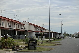
Panaga is a coastal settlement on the north-east coast of the island of Borneo, in the Bruneian district of Belait. Officially known in Malay as Kampung Panaga, it is a village-level subdivision under Seria, a mukim or subdistrict of Belait. The settlement of Panaga comprises a public housing estate under the National Housing Scheme and the housing estate of Brunei Shell Petroleum (BSP), the main oil and gas company in the country. Panaga is also home to the headquarters of the company itself. The postcode for Panaga is KB4533.
Mumong is a residential suburb of Kuala Belait, the principal town of Belait District, Brunei. It comprises the original Mumong settlement, as well as the Mumong public housing estate of the Landless Indigenous Citizens' Housing Scheme. However, it officially consists of two village subdivisions, namely Mumong 'A' and Mumong 'B', which are under the mukim of Kuala Belait.

Rasau is an area in Brunei. The area contains one of the two oil fields of Brunei, the Rasau Field, and a small village, Kampong Rasau, which has a population of 103.

Kampong Sungai Duhon is a village that is located within the town of Kuala Belait in Mukim Kuala Belait, Belait District of Brunei. The postcode is KA3131.

Seri Kenangan Beach, also known as Tutong Beach, is a beach and spit in Kuala Tutong, Mukim Pekan Tutong, Tutong District. It is located at an estimated distance of 2 km west of Tutong town. It can also be noted that clay soils were found in the areas around the beach.

Kampong Lumut or commonly known as Lumut, is a coastal settlement in Belait District, Brunei, about 30 kilometres (19 mi) from the district town Kuala Belait. The total population was 11,273 in 2016.

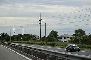
Transport in Brunei consists of air, land, and sea transport. Previously there was some rail transport in Brunei, but eventually most of it was closed down. Several public and commercial sector organizations are in charge of creating and overseeing these networks and infrastructures. The Ministry of Transport and Infocommunications (MTIC) is in charge of overseeing the maritime and aviation industries, as well as planning and regulating all kinds of land transportation.

Kampong Danau, simply known as Danau, is a coastal village in Tutong District, Brunei, about 21 kilometres (13 mi) from the district town Pekan Tutong. It has a total area of 6.5023 square kilometres (2.5106 sq mi); the total population was 1,072 in 2016. It is one of the villages within Mukim Telisai.

Kampong Petani, also simply known as Petani, is a populated area in Tutong, the town of Tutong District, Brunei. It is officially a village-level subdivision under the mukim or subdistrict of Pekan Tutong, as well as a designated postcode area with the postcode TA1741. Parts of Petani area is also under the spatial jurisdiction of the municipality of Tutong. Petani is de facto the commercial area of the town.

Kampong Kumbang Pasang, or simply Kumbang Pasang, is a village within Mukim Kianggeh in Brunei-Muara District, Brunei. It is also part of the municipal area of the capital Bandar Seri Begawan. The population was 563 in 2016. It has the postcode BA1511. The village formerly hosts a rubber plantation and was named Kumbang Pasang Estate. Notably the village was once its own Mukim, known as Mukim Kumbang Pasang.

Kampong Sungai Liang is a village in Belait District, Brunei, about 40 kilometres (25 mi) from the district's principal town Kuala Belait and 20 kilometres (12 mi) from the oil town Seria. The population was 910 in 2016. It is one of the villages within Mukim Liang. The postcode is KC1135.

The Belait River is a river in Belait District, Brunei. It is the longest of the four main rivers in the country.

Belait Beach, also known as KualaBelait Beach, is a beach in Kuala Belait, Mukim Kuala Belait, Belait District, Brunei. The beach used to stretch from Kuala Belait to Pelumpong Spit but was cut and split at Muara Beach.

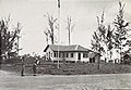
The Istana Pantai is one of the temporary official residence of the then Sultan of Brunei, Omar Ali Saifuddien III. The palace is located at Jalan Kuala Tutong, Tutong, Tutong District, Brunei. Moreover, the building has become a tourist attraction and historical site in the present day.