Frederick County is located in the Commonwealth of Virginia. As of the 2020 census, the population was 91,419. Its county seat is Winchester. The county was formed in 1743 by the splitting of Orange County. It is Virginia's northernmost county. Frederick County is included in the Winchester, VA-WV Metropolitan Statistical Area, which is also included in the Washington-Baltimore-Northern Virginia, DC-MD-VA-WV-PA Combined Statistical Area.

Winchester is the northwesternmost independent city in the Commonwealth of Virginia, United States. It is the county seat of Frederick County, although the two are separate jurisdictions. As of the 2020 census, the city's population was 28,120. It is the principal city of the Winchester metropolitan area extending into West Virginia, which is a part of the Washington–Baltimore combined statistical area. Winchester is home to Shenandoah University and the Museum of the Shenandoah Valley.

Stephens City is an incorporated town in the southern part of Frederick County, Virginia, United States, with a population of 2,016 at the time of the 2020 census, and an estimated population of 2,096 in 2022. Founded by Peter Stephens in the 1730s, the colonial town was chartered and named for Lewis Stephens in October 1758. It was originally settled by German Protestants from Heidelberg.

U.S. Route 522 is a spur route of US 22 in the states of Virginia, West Virginia, Maryland, and Pennsylvania. The U.S. Highway travels in a north-south direction, and runs 308.59 miles (496.63 km) from US 60 near Powhatan, Virginia, to its northern terminus at US 11 and US 15 near Selinsgrove, Pennsylvania. US 522 serves many small cities and towns in the Piedmont, Blue Ridge Mountains, and northern Shenandoah Valley of Virginia. The highway serves the Virginia communities of Goochland, Mineral, Culpeper, the town of Washington, and Front Royal and the independent city of Winchester. US 522 then follows the Ridge-and-Valley Appalachians north and then east through the Eastern Panhandle of West Virginia, a 2-mile-wide (3.2 km) stretch of Western Maryland, and South Central Pennsylvania to its terminus in the Susquehanna Valley. The highway serves Berkeley Springs, West Virginia; Hancock, Maryland; and the Pennsylvania communities of McConnellsburg, Mount Union, Lewistown, and Middleburg.

The Third Battle of Winchester, also known as the Battle of Opequon or Battle of Opequon Creek, was an American Civil War battle fought near Winchester, Virginia, on September 19, 1864. Union Army Major General Philip Sheridan defeated Confederate Army Lieutenant General Jubal Early in one of the largest, bloodiest, and most important battles in the Shenandoah Valley. Among the 5,000 Union casualties were one general killed and three wounded. The casualty rate for the Confederates was high: about 4,000 of 15,500. Two Confederate generals were killed and four were wounded. Participants in the battle included two future presidents of the United States, two future governors of Virginia, a former vice president of the United States, and a colonel whose grandson, George S. Patton became a famous general in World War II.

Virginia State Route 7 (VA 7) is a major primary state highway and busy commuter route in northern Virginia, United States. It travels southeast from downtown Winchester to SR 400 in downtown Alexandria. Its route largely parallels those of the Washington & Old Dominion Trail and the Potomac River. Between its western terminus and Interstate 395 (I-395), SR 7 is part of the National Highway System. In 1968, the Virginia State Highway Commission designated the road as the "Harry Flood Byrd Highway" between Alexandria and Winchester to commemorate Harry F. Byrd Sr. (1887–1966).

West Virginia Route 45 is a state highway in the U.S. state of West Virginia. The state highway runs 25.8 miles (41.5 km) from the Virginia state line near Glengary east to WV 230 and WV 480 in Shepherdstown. WV 45 connects the communities of Glengary and Arden in southwestern Berkeley County with the county seat of Martinsburg. The state highway also connects Shepherdstown in northern Jefferson County with Martinsburg, where the highway meets Interstate 81 (I-81), U.S. Route 11, and WV 9.

Opequon is an unincorporated community along Opequon Creek in Frederick County, northwestern Virginia. Also known as Kernstown, the community center is served by Cedar Creek Grade at Miller Road.
Burnt Factory is an unincorporated community in Frederick County, Virginia, United States. Burnt Factory lies to the northeast of Winchester along Opequon Creek. The community is centered at the intersection of Burnt Factory and Jordan Springs Roads.

U.S. Route 11 (US 11) is a north–south United States Numbered Highway in western Virginia. At 339 miles (546 km), it is the second longest numbered route and longest primarily north–south route in the state. It enters the state from Tennessee as the divided routes US 11E and US 11W at Bristol, roughly follows the West Virginia border through the Blue Ridge Mountains and Shenandoah Valley, and enters the Eastern Panhandle of West Virginia from Frederick County. Most of the route closely parallels I-81. From south to north, US 11 serves the cities and towns of Bristol, Abingdon, Wytheville, Pulaski, Radford, Christiansburg, Roanoke, Lexington, Staunton, Harrisonburg, Strasburg, and Winchester. As one of the original U.S. Highways, it was first designated through Virginia in 1926 and has largely followed the same route since. Prior to the construction of the Interstate Highway System, it was the primary long-distance route for traversing the western part of the state. Much of it roughly follows the Great Wagon Road, a colonial-era road that followed the Appalachian Mountains from Georgia to Pennsylvania.

U.S. Route 17 (US 17) is a part of the United States Numbered Highway System that runs from Punta Gorda, Florida, to Winchester, Virginia. In Virginia, the U.S. Highway runs 255.83 miles (411.72 km) from the North Carolina state line in Chesapeake north to its northern terminus at US 11, US 50, and US 522 in Winchester. US 17 is a major highway in the eastern half of Virginia. The U.S. Highway connects the Albemarle Region of North Carolina with the Hampton Roads metropolitan area. Within the urban area, US 17 passes through the South Hampton Roads cities of Chesapeake, Portsmouth, and Suffolk and the Virginia Peninsula city of Newport News. Between Yorktown and Fredericksburg, the U.S. Highway serves as the primary highway of the Middle Peninsula. At Fredericksburg, US 17 leaves the Atlantic Plain; the highway passes through the Piedmont town of Warrenton and crosses the Blue Ridge Mountains on its way to Winchester in the Shenandoah Valley. The route from Tappahannock to Winchester roughly follows the Confederate march during the Civil War to Gettysburg.

State Route 277 is a primary state highway in the U.S. state of Virginia. Known also as Fairfax Pike and Fairfax Street, the state highway runs 4.72 miles (7.60 km) from U.S. Route 11 and SR 631 in Stephens City in southern Frederick County east to US 522 and US 340 at Double Tollgate in the southwestern corner of Clarke County.
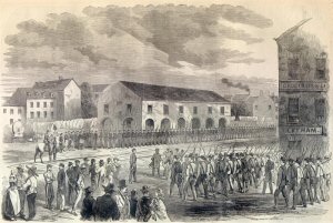
The city of Winchester, Virginia, and the surrounding area, were the site of numerous battles during the American Civil War, as contending armies strove to control the lower Shenandoah Valley. Winchester changed hands more often than any other Confederate city.
Wadesville is an unincorporated community in Clarke County in the U.S. state of Virginia. Wadesville is located along Opequon Creek at Locke's Ford.
The 123rd Ohio Infantry Regiment, sometimes 123rd Ohio Volunteer Infantry was an infantry regiment in the Union Army during the American Civil War.
Robert White was an early American physician, military officer, pioneer, and planter in the Colony of Virginia.

John Hite House, also known as Springdale, is a historic home located at Bartonsville, Frederick County, Virginia. The original house was built in 1753, and is of native limestone laid in irregular ashlar with some random-coursed limestone rubble used on its secondary walls. The stone was quarried from a nearby field. The house faced east, overlooking the Indian Trail/Great Valley Road, where Jost Hite's tavern was situated at the ford of the Opequon Creek. The Springdale property was originally the home of Jost Hite, the earliest white settler in the lower Shenandoah Valley. Jost Hite was Pennsylvania Dutch and moved to the Valley in August 1731. His son, Colonel John I. Hite, built the Springdale house. Also on the property are the contributing stone ruins of what is believed to be Jost Hite's tavern/house of the 1730s, a stone shed, and small wood-frame spring house. The house and 288 acres were sold March 20, 1802 to Richard Peters Barton (1763-1821), a native of Lancaster Pa. who had spent some years in Dinwiddie County, Va., before moving to Frederick County c. 1798. [Frederick County Deed Book S.C.4, p. 484.] The house passed to his son Richard Walker Barton (1799-1859) and in 1858 to another son, David Walker Barton (1801-1863), remaining in the Barton family until 1873. There is a small Barton family cemetery on the property. When the Valley Turnpike was chartered in 1834, the road was laid out to run on the west side of Springdale. Soon thereafter, the house was reoriented to face the Turnpike, and the Richard W. Bartons built the then-fashionable Greek Revival four-bay, two-story portico. [Garland W. Quarles, "Some Old Houses in Frederick County, Virginia", Winchester, 1990. Revised ed. PP. 131–135.]
Gabriel Jones was an 18th-century Welsh American lawyer, legislator, court clerk and civil servant in the colony of Virginia.
Morgan Bryan, an immigrant, led his extended family to the Forks of the Yadkin in the Province of North Carolina, now the state of North Carolina, and founded Bryan's Settlement there. He was known for "establishing critical settlements down the Shenandoah Valley along the Great Wagon Road in the Southeast." Bryan and his wife Martha raised their granddaughter Rebecca Bryan Boone, the wife of Daniel Boone.
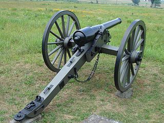
The 4th U.S. Artillery, Battery E was an artillery battery that served in the Union Army during the American Civil War. The unit fought at the battles of Kernstown, Port Republic, Rappahannock Station, Second Bull Run, Chantilly, Antietam, and Fredericksburg in 1862. The battery transferred to the Cavalry Corps where it served for the rest of the war. In 1863, 4th U.S. Artillery, Battery E fought at Chancellorsville, Gettysburg, Culpeper, Bristoe Station, and Mine Run. In 1864, the unit fought at the Wilderness, Todd's Tavern, Yellow Tavern, Totopotomoy, Cold Harbor, the Wilson-Kautz Raid, Opequon, Fisher's Hill, and Cedar Creek. In 1865, it saw action at Dinwiddie Court House, Five Forks, Sailor's Creek, and Appomattox before taking part in the Grand Review of the Armies.