The First Battle of Winchester, fought on May 25, 1862, in and around Frederick County, Virginia, and Winchester, Virginia, was a major victory in Confederate Army Maj. Gen. Thomas J. "Stonewall" Jackson's Campaign through the Shenandoah Valley during the American Civil War. Jackson enveloped the right flank of the Union Army under Maj. Gen. Nathaniel P. Banks and pursued it as it fled across the Potomac River into Maryland. Jackson's success in achieving force concentration early in the fighting allowed him to secure a more decisive victory which had escaped him in previous battles of the campaign.

U.S. Route 522 is a spur route of US 22 in the states of Virginia, West Virginia, Maryland, and Pennsylvania. The U.S. Highway travels in a north-south direction, and runs 308.59 miles (496.63 km) from US 60 near Powhatan, Virginia, to its northern terminus at US 11 and US 15 near Selinsgrove, Pennsylvania. US 522 serves many small cities and towns in the Piedmont, Blue Ridge Mountains, and northern Shenandoah Valley of Virginia. The highway serves the Virginia communities of Goochland, Mineral, Culpeper, the town of Washington, and Front Royal and the independent city of Winchester. US 522 then follows the Ridge-and-Valley Appalachians north and then east through the Eastern Panhandle of West Virginia, a 2-mile-wide (3.2 km) stretch of Western Maryland, and South Central Pennsylvania to its terminus in the Susquehanna Valley. The highway serves Berkeley Springs, West Virginia; Hancock, Maryland; and the Pennsylvania communities of McConnellsburg, Mount Union, Lewistown, and Middleburg.

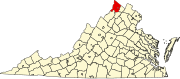
The Second Battle of Winchester was fought between June 13 and June 15, 1863, in Frederick County and Winchester, Virginia as part of the Gettysburg Campaign during the American Civil War. As Confederate Lieutenant General Richard S. Ewell moved north through the Shenandoah Valley in the direction of Pennsylvania, his corps defeated the Union Army garrison commanded by Major General Robert H. Milroy, capturing Winchester and numerous Union prisoners.

The Third Battle of Winchester, also known as the Battle of Opequon or Battle of Opequon Creek, was an American Civil War battle fought near Winchester, Virginia, on September 19, 1864. Union Army Major General Philip Sheridan defeated Confederate Army Lieutenant General Jubal Early in one of the largest, bloodiest, and most important battles in the Shenandoah Valley. Among the 5,000 Union casualties were one general killed and three wounded. The casualty rate for the Confederates was high: about 4,000 of 15,500. Two Confederate generals were killed and four were wounded. Participants in the battle included two future presidents of the United States, two future governors of Virginia, a former vice president of the United States, and a colonel whose grandson, George S. Patton became a famous general in World War II.

The Valley campaigns of 1864 began as operations initiated by Union Lieutenant General Ulysses S. Grant and resulting battles that took place in the Shenandoah Valley of Virginia during the American Civil War from May to October 1864. Some military historians divide this period into three separate campaigns. This article considers them together, as the campaigns interacted and built upon one another.

West Virginia Route 51 is a state highway that runs west to east from Berkeley County to Jefferson County in West Virginia's Eastern Panhandle. The western terminus is at WV 45 northwest of Gerrardstown. The eastern terminus is at an interchange with U.S. Route 340 and WV 9 east of downtown Charles Town. US 340 continues to the east on the same roadway as WV 51.

Opequon Creek is an approximately 35 mile tributary stream of the Potomac River. It flows into the Potomac northeast of Martinsburg in Berkeley County, West Virginia, and its source lies northwest of the community of Opequon at the foot of Great North Mountain in Frederick County, Virginia. The Opequon forms part of the boundary between Frederick and Clarke counties in Virginia and also partially forms the boundary between Berkeley and Jefferson counties in West Virginia's Eastern Panhandle.

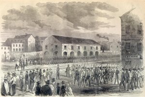
Bunker Hill is an unincorporated community in Berkeley County, West Virginia, United States, located in the lower Shenandoah Valley on Winchester Pike at its junction with County Route 26 south of Martinsburg. It is the site of the confluence of Torytown Run and Mill Creek, a tributary of Opequon Creek which flows into Winchester, Virginia. According to the 2000 census, the Bunker Hill community has a population of 5,319.
Bartonsville is an unincorporated community located along Opequon Creek in Frederick County, Virginia between Winchester and Stephens City. Bartonsville is on Springdale Road to the west of Valley Pike. Historically, it has been referred to as Barton's Mill and Bartonville. The area of Bartonsville was first settled by the Hite Family in 1733. During the American Civil War, the village was garrisoned with a small stone fort of unknown location held by the Union Army.

Opequon is an unincorporated community along Opequon Creek in Frederick County, Virginia. Opequon is located on Cedar Creek Grade at Miller Road and also known as Kernstown, Virginia. The community of Opequon was designated a National Historic District in 2002. Opequon School, which was in operation from 1884 to 1934, remains standing on Glass Spring Road in town. Also on Glass Spring Road is the Second Opequon Presbyterian Church. Home to Opequon Quaker Camp on brucetown road.
Mill Creek is a 14.5-mile-long (23.3 km) tributary of Opequon Creek, belonging to the Potomac River and Chesapeake Bay watersheds, located in Berkeley County in West Virginia's Eastern Panhandle. Its name reflects its past as a popular site for various types of mills, beginning with one constructed by Morgan Morgan in the mid-18th century near his cabin in present-day Bunker Hill.
Kernstown is an unincorporated community within the independent city of Winchester, Virginia. Parts of Kernstown also lie within Frederick County. It is centered along the Valley Pike U.S. Route 11. During the American Civil War, the first and second Battles of Kernstown were fought here.
Abrams Creek is an 11.2-mile-long (18.0 km) tributary stream of Opequon Creek in Frederick County and the independent city of Winchester in Virginia. Abrams Creek rises north of Round Hill and flows in a southeasterly direction through Winchester. From Winchester, Abrams Creek flows east into Opequon Creek. The stream was originally known as Abraham's Creek.

U.S. Route 17 (US 17) is a part of the United States Numbered Highway System that runs from Punta Gorda, Florida, to Winchester, Virginia. In Virginia, the U.S. Highway runs 255.83 miles (411.72 km) from the North Carolina state line in Chesapeake north to its northern terminus at US 11, US 50, and US 522 in Winchester. US 17 is a major highway in the eastern half of Virginia. The U.S. Highway connects the Albemarle Region of North Carolina with the Hampton Roads metropolitan area. Within the urban area, US 17 passes through the South Hampton Roads cities of Chesapeake, Portsmouth, and Suffolk and the Virginia Peninsula city of Newport News. Between Yorktown and Fredericksburg, the U.S. Highway serves as the primary highway of the Middle Peninsula. At Fredericksburg, US 17 leaves the Atlantic Plain; the highway passes through the Piedmont town of Warrenton and crosses the Blue Ridge Mountains on its way to Winchester in the Shenandoah Valley. The route from Tappahannock to Winchester roughly follows the Confederate march during the Civil War to Gettysburg.

State Route 277 is a primary state highway in the U.S. state of Virginia. Known also as Fairfax Pike and Fairfax Street, the state highway runs 4.72 miles (7.60 km) from U.S. Route 11 and SR 631 in Stephens City in southern Frederick County east to US 522 and US 340 at Double Tollgate in the southwestern corner of Clarke County.
The city of Winchester, Virginia, and the surrounding area, were the site of numerous battles during the American Civil War, as contending armies strove to control the lower Shenandoah Valley. Winchester changed hands more often than any other Confederate city.
Wadesville is an unincorporated community in Clarke County in the U.S. state of Virginia. Wadesville is located along Opequon Creek at Locke's Ford.
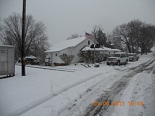
Millbank, also known as Spout Spring and Hillwood, is a historic house at 3100 Berryville Pike, in Frederick County, Virginia east of the city of Winchester. The two story brick mansion was built c. 1850 by Isaac and Daniel T. Wood. It is one of the largest Greek Revival houses in the county, standing on a hill overlooking Berryville Pike and Opequon Creek, which flows east of the property. The house has a typical I-house plan, with two entrances, one facing the highway and one the creek. Both were originally sheltered by Doric-columned porches, but the side entry's porch has been removed by vandals. The house was previously owned by the Winchester-Frederick Service Authority, who took the property in 1984 by eminent domain to construct the adjacent sewage treatment plant. It is now owned by The Fort Collier Civil War Center, Inc. (2014.) This nonprofit organization owns historic Fort Collier, another Third Battle of Winchester site.
The action at Abraham's Creek was an engagement on September 13, 1864 between Union Army and Confederate States Army forces during a Union reconnaissance in force toward Winchester, Virginia. The action occurred during skirmishing, maneuvering and scouting before the Third Battle of Winchester on September 19, 1864 in the Valley Campaigns of 1864 during the American Civil War. The Union force successfully completed the mission and captured about 173 Confederate prisoners.