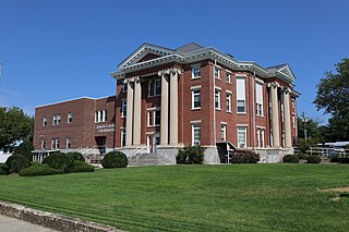
Hardy County is a county in the U.S. state of West Virginia. As of the 2020 census, the population was 14,299. Its county seat is Moorefield. The county was created from Hampshire County in 1786 and named for Samuel Hardy, a distinguished Virginian.

Buena Vista is an independent city located in the Blue Ridge Mountains region of Virginia in the United States. As of the 2020 census, the population was 6,641. The Bureau of Economic Analysis combines the independent cities of Buena Vista and Lexington, along with surrounding Rockbridge County, for statistical purposes.

Shinnston is a city and former coal town in Harrison County, West Virginia, United States, along the West Fork River. In 1778, Levi Shinn constructed his log home along what is now Route 19; today it is the oldest standing structure in north-central West Virginia. As of the 2020 census, Shinnston had a population of 2,332.

Gowanda is a village in western New York, United States. It lies partly in Erie County and partly in Cattaraugus County. The population was 2,512 at the 2020 census. The name is derived from a local Seneca language term meaning "almost surrounded by hills" or "a valley among the hills". The Erie County portion of Gowanda is part of the Buffalo–Niagara Falls metropolitan statistical area, while the Cattaraugus County portion is part of the Olean micropolitan statistical area.

The Washington–Baltimore combined statistical area is a statistical area including two overlapping metropolitan areas, Washington, D.C., and Baltimore, Maryland. The region includes Central Maryland, Northern Virginia, three counties in the Eastern Panhandle of West Virginia, and one county in South Central Pennsylvania. It is the most educated, highest-income, and third-largest combined statistical area in the United States behind New York–Newark and Los Angeles–Long Beach.

U.S. Route 522 is a spur route of US 22 in the states of Virginia, West Virginia, Maryland, and Pennsylvania. The U.S. Highway travels in a north-south direction, and runs 308.59 miles (496.63 km) from US 60 near Powhatan, Virginia, to its northern terminus at US 11 and US 15 near Selinsgrove, Pennsylvania. US 522 serves many small cities and towns in the Piedmont, Blue Ridge Mountains, and northern Shenandoah Valley of Virginia. The highway serves the Virginia communities of Goochland, Mineral, Culpeper, the town of Washington, and Front Royal and the independent city of Winchester. US 522 then follows the Ridge-and-Valley Appalachians north and then east through the Eastern Panhandle of West Virginia, a 2-mile-wide (3.2 km) stretch of Western Maryland, and South Central Pennsylvania to its terminus in the Susquehanna Valley. The highway serves Berkeley Springs, West Virginia; Hancock, Maryland; and the Pennsylvania communities of McConnellsburg, Mount Union, Lewistown, and Middleburg.
The Northwestern Turnpike is a historic road in West Virginia, important for being historically one of the major roads crossing the Appalachians, financed by the Virginia Board of Public Works in the 1830s. In modern times, west of Winchester, Virginia, U.S. Route 50 follows the path of the Northwestern Turnpike into West Virginia, whose major Corridor D project follows the western section of the original Northwestern Turnpike.
Tannery is an unincorporated community in Hardy County, West Virginia, United States. Tannery is located south of Moorefield on the South Fork South Branch Potomac River.

The Greenbrier River Trail (GRT), is a lineal state park comprising a 77.1-mile (124.1 km) rail trail between North Caldwell and Cass in eastern West Virginia.

Sperryville is a census-designated place (CDP) located in the western section of Rappahannock County, Virginia, United States, near Shenandoah National Park. It consists of a village with two main streets along the two branches of the Thornton River, together with surrounding pasture- and farmland. The population as of the 2010 Census was 342.
Devil's Backbone State Forest is a 705.5-acre (285.5 ha) state forest in Shenandoah County, Virginia. It lies on the slope of North Mountain in the drainage area of Cedar Creek near Star Tannery west of Strasburg. The forest was established by a grant by John and Bernice Hoffman, who owned the land since 1950.

Georgetown is an unincorporated community at the junction of Bradley, Hamilton, and Meigs counties, Tennessee. The community is located along State Route 60 near its intersection with State Route 58.
Gravel Springs is an unincorporated community in Frederick County, Virginia, United States. Gravel Springs was established in 1872. It lies south of Star Tannery at the intersection of Brill, Star Tannery, and Gravel Springs Roads.
Cedar Creek is a 40.5-mile-long (65.2 km) tributary stream of the North Fork Shenandoah River in northern Virginia in the United States. It forms the majority of the boundary between Frederick and Shenandoah counties. Cedar Creek's confluence with the North Fork Shenandoah is located at Strasburg.

State Route 55 is a primary state highway in the U.S. state of Virginia. Known for most of its length as John Marshall Highway, the state highway runs 64.71 miles (104.14 km) from the West Virginia state line, where the highway continues as West Virginia Route 55, east to U.S. Route 29 in Gainesville. West of its interchange with Interstate 81 (I-81) in Strasburg, SR 55 runs concurrently with the easternmost portion of US 48 as part of Corridor H. East of Front Royal, the state highway serves as the local complement of I-66 as it passes through the towns of Marshall, The Plains, and Haymarket.

Big Spring State Park is a 45-acre (18 ha) Pennsylvania state park in Toboyne Township, Perry County, Pennsylvania in the United States. The park is on Pennsylvania Route 274, 5.5 miles (8.9 km) southwest of New Germantown. Big Spring State Park is a hiking and picnic area. A partially completed railroad tunnel in Conococheague Mountain is a feature of the park.
Cottageville is an unincorporated community in western Jackson County, West Virginia, United States. It lies along West Virginia Route 331 northwest of the city of Ripley, the county seat of Jackson County. Established in 1858, its elevation is 594 feet (181 m). Although Cottageville is unincorporated, it has a post office, with the ZIP code of 25239. It also is the site of the annual Jackson County Junior Fair. Michael Coleman, a well known early Indian fighter, was killed and buried in the area, according to a historical marker placed by the state of WV. The wooden Grist Mill located here since the 1840s burned to the ground in the summer of 1965. Its foundation stones remain. It had remained in operation full-time until 1930, part-time until 1937. Cottageville was a commercial center with a bank, newspaper, tannery, blacksmith, several stores, a railroad station on the B & O and many other businesses in the early part of the twentieth century. Its heyday faded with the closing of the mill and the improvement of roads in the county. The B & O pulled up its tracks to the county seat, Ripley, in the mid-nineteen-sixties. Less than a mile from the old town, the county operated what folks called the "poor farm," an early version of a welfare commune. That closed in the thirties with the New Deal. That land is now the Jackson County Junior Fairgrounds.
Boiceville is a hamlet in the town of Olive, Ulster County, New York, United States. Located at the intersection of New York State Route 28 and New York State Route 28A, Boiceville is within Catskill State Park.

John Brown Farm, Tannery & Museum, 17620 John Brown Rd., Guys Mills, PA 16327, is a historic archaeological site located in Richmond Township, Crawford County, Pennsylvania. The tannery was built in 1825 by famed abolitionist John Brown (1800–1859), who lived on the site from 1825 to 1835. The tannery was about 0.25 miles (0.40 km) from the new Pennsylvania and Ohio Canal.


