Kidder, Missouri

Last updated
Kidder, Missouri
Caldwell County Missouri Incorporated and Unincorporated areas Kidder Highlighted.svg
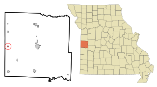
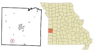
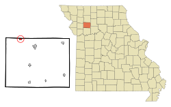
Location of Kidder, Missouri
Coordinates: 39°46′56″N94°06′08″W / 39.78222°N 94.10222°W / 39.78222; -94.10222 Coordinates: 39°46′56″N94°06′08″W / 39.78222°N 94.10222°W / 39.78222; -94.10222
Country United States
State Missouri
County Caldwell
Area
[1]
  Total0.40 sq mi (1.04 km2)
  Land0.40 sq mi (1.04 km2)
  Water0.00 sq mi (0.00 km2)
Elevation
[2]
1,027 ft (313 m)
Population
 (2020)
  Total267
  Density664.18/sq mi (256.22/km2)
Time zone UTC-6 (Central (CST))
  Summer (DST) UTC-5 (CDT)
ZIP code
64649
Area code 816
FIPS code 29-38522 [3]
GNIS feature ID2395526 [2]

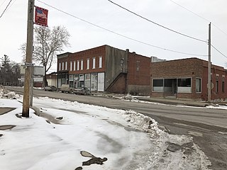
Kidder is a city in northwest Caldwell County, Missouri, The population was 267 at the 2020 census. [4]

Contents

The city was laid out in 1860 by H.B. Kidder of the Kidder Land Company in Boston, [5] which was seeking to encourage non-slave owning European immigrants to settle along the Hannibal and St. Joseph Railroad which at the time was the furthest west railroad in the United States.

The city received national publicity in 2004 after a student at the Thayer Learning Center in the community died after not receiving treatment early enough. In 2009 the Center was sold to become the White Buffalo Academy. The campus was formerly Thayer College and Thayer High School. Thayer College was founded in 1871 and closed in 1876. It reopened in 1877 as the Kidder Institute and operated under the auspices of the Congregational Church of Missouri. The building was used as a public school from 1934 to 1981. [6]

Geography

According to the United States Census Bureau, the city has a total area of 0.40 square miles (1.04 km2), all land. [7]

Demographics

Historical population
CensusPop.Note
1880 260
1890 32223.8%
1900 35710.9%
1910 306−14.3%
1920 3359.5%
1930 314−6.3%
1940 270−14.0%
1950 222−17.8%
1960 2240.9%
1970 2313.1%
1980 26514.7%
1990 241−9.1%
2000 27112.4%
2010 32319.2%
2020 267−17.3%
U.S. Decennial Census [8]

2010 census

As of the census [9] of 2010, there were 323 people, 121 households, and 88 families residing in the city. The population density was 807.5 inhabitants per square mile (311.8/km2). There were 132 housing units at an average density of 330.0 per square mile (127.4/km2). The racial makeup of the city was 96.9% White, 0.6% from other races, and 2.5% from two or more races. Hispanic or Latino of any race were 0.6% of the population.

There were 121 households, of which 34.7% had children under the age of 18 living with them, 60.3% were married couples living together, 9.1% had a female householder with no husband present, 3.3% had a male householder with no wife present, and 27.3% were non-families. 24.8% of all households were made up of individuals, and 13.2% had someone living alone who was 65 years of age or older. The average household size was 2.67 and the average family size was 3.15.

The median age in the city was 40.9 years. 26.9% of residents were under the age of 18; 7.1% were between the ages of 18 and 24; 20.8% were from 25 to 44; 29.6% were from 45 to 64; and 15.5% were 65 years of age or older. The gender makeup of the city was 50.5% male and 49.5% female.

2000 census

As of the census [3] of 2000, there were 271 people, 109 households, and 79 families residing in the city. The population density was 663.7 inhabitants per square mile (256.3/km2). There were 119 housing units at an average density of 291.5 per square mile (112.5/km2). The racial makeup of the city was 99.26% White, 0.37% African American, and 0.37% from two or more races. Hispanic or Latino of any race were 2.95% of the population.

There were 109 households, out of which 33.9% had children under the age of 18 living with them, 57.8% were married couples living together, 9.2% had a female householder with no husband present, and 27.5% were non-families. 27.5% of all households were made up of individuals, and 13.8% had someone living alone who was 65 years of age or older. The average household size was 2.49 and the average family size was 3.01.

In the city the population was spread out, with 28.4% under the age of 18, 6.6% from 18 to 24, 23.2% from 25 to 44, 28.8% from 45 to 64, and 12.9% who were 65 years of age or older. The median age was 38 years. For every 100 females, there were 90.8 males. For every 100 females age 18 and over, there were 90.2 males.

The median income for a household in the city was $26,771, and the median income for a family was $41,477. Males had a median income of $26,818 versus $18,906 for females. The per capita income for the city was $13,424. About 15.6% of families and 22.1% of the population were below the poverty line, including 41.8% of those under the age of eighteen and 5.3% of those 65 or over.

Related Research Articles

<span class="mw-page-title-main">Thayer, Iowa</span> City in Iowa, United States

Thayer is a city in Union County, Iowa, United States. The population was 51 at the time of the 2020 census.

<span class="mw-page-title-main">Thayer, Kansas</span> City in Neosho County, Kansas

Thayer is a city in Neosho County, Kansas, United States. As of the 2020 census, the population of the city was 432.

<span class="mw-page-title-main">Amoret, Missouri</span> City in Missouri, United States

Amoret is a city in western Bates County, Missouri, and is part of the Kansas City metropolitan area within the United States. The population was 133 at the 2020 census.

<span class="mw-page-title-main">Bosworth, Missouri</span> City in Missouri, United States

Bosworth is a city in Carroll County, Missouri, United States. The population was 213 at the 2020 U.S. Census.

<span class="mw-page-title-main">Mosby, Missouri</span> City in Missouri, United States

Mosby is a city in Clay County, Missouri, United States, along the Fishing River. The population was 101 at the 2020 census. It is part of the Kansas City metropolitan area.

<span class="mw-page-title-main">Blairstown, Missouri</span> City in Missouri, United States

Blairstown is a city in Henry County, Missouri, United States. The population was 97 at the 2010 census.

<span class="mw-page-title-main">Alba, Missouri</span> City in Missouri, United States

Alba is a city in Jasper County, Missouri, United States. The population was 544 at the 2020 census.

<span class="mw-page-title-main">Thayer, Missouri</span> City in Missouri, United States

Thayer is a city in Oregon County, Missouri, United States. The population was 1,883 at the 2020 census. Its original name was Augusta.

<span class="mw-page-title-main">Hayti Heights, Missouri</span> City in Missouri, United States

Hayti Heights is a city in eastern Pemiscot County in the bootheel of southeast Missouri, United States. The population was 515 at the 2020 census.

<span class="mw-page-title-main">Homestown, Missouri</span> City in Missouri, United States

Homestown is a city in Pemiscot County, Missouri, United States. The population was 73 at the 2020 census.

<span class="mw-page-title-main">Pleasant Hope, Missouri</span> City in Missouri, United States

Pleasant Hope is a city in Polk County, Missouri, United States. The population was 614 at the 2010 census. It is part of the Springfield, Missouri Metropolitan Statistical Area.

<span class="mw-page-title-main">Oakland, Missouri</span> City in Missouri, United States

Oakland is a city in St. Louis County, Missouri, United States. The population was 1,381 at the 2010 census.

<span class="mw-page-title-main">Velda City, Missouri</span> City in Missouri, United States

Velda City is a city in St. Louis County, Missouri, United States. The population was 1,420 at the 2010 census.

<span class="mw-page-title-main">Dudley, Missouri</span> City in Missouri, United States

Dudley is a city in Stoddard County, Missouri, United States. The population was 232 at the 2010 census.

<span class="mw-page-title-main">Galena, Missouri</span> City in Missouri, United States

Galena is a city in Stone County, Missouri, United States. The population was 455 at the 2020 census. It is the county seat of Stone County. Galena is part of the Branson, Missouri Micropolitan Statistical Area.

<span class="mw-page-title-main">Bronaugh, Missouri</span> City in Missouri, United States

Bronaugh is a city in southwest Vernon County, Missouri, United States. The population was 249 at the 2010 census.

<span class="mw-page-title-main">Deshler, Nebraska</span> City in Nebraska, United States

Deshler is a city in Thayer County, Nebraska, United States. The population was 739 at the 2020 census.

<span class="mw-page-title-main">Clarkson Valley, Missouri</span> City in Missouri, United States

Clarkson Valley is a city in St. Louis County, Missouri, United States. The population was 2,609 at the 2020 census.

<span class="mw-page-title-main">Ionia, Missouri</span> Village in Missouri, United States

Ionia is a village in northern Benton and southern Pettis counties in the U.S. state of Missouri. The population was 88 at the 2010 census.

<span class="mw-page-title-main">Blackburn, Missouri</span> City in Missouri, United States

Blackburn is a city in Lafayette and Saline counties in the U.S. state of Missouri and is part of the Kansas City metropolitan area. The population was 249 at the 2010 census.

References

  1. "ArcGIS REST Services Directory". United States Census Bureau. Retrieved August 28, 2022.
  2. 1 2 U.S. Geological Survey Geographic Names Information System: Kidder, Missouri
  3. 1 2 "U.S. Census website". United States Census Bureau . Retrieved 2008-01-31.
  4. "Explore Census Data". data.census.gov. Retrieved 2021-12-27.
  5. "Caldwell County, Missouri Place Names, 1928-1945 | Western Historical Manuscript Collection - Columbia". Archived from the original on 2011-07-20. Retrieved 2009-10-19.
  6. Earngey, Bill (1995). Missouri Roadsides: The Traveler's Companion. ISBN   9780826210210.
  7. "US Gazetteer files 2010". United States Census Bureau. Archived from the original on 2012-01-25. Retrieved 2012-07-08.
  8. "Census of Population and Housing". Census.gov. Retrieved June 4, 2015.
  9. "U.S. Census website". United States Census Bureau . Retrieved 2012-07-08.