Kingsclear Parish, New Brunswick

Last updated

Kingsclear
York County NB - Kingsclear Parish.PNG
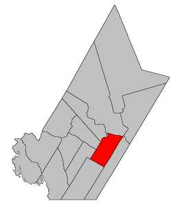
Location within York County, New Brunswick.
Coordinates: 45°53′06″N66°54′27″W / 45.885°N 66.9075°W / 45.885; -66.9075
Country Flag of Canada (Pantone).svg  Canada
Province Flag of New Brunswick.svg  New Brunswick
County York
Erected1786
Area
[1]
  Land150.11 km2 (57.96 sq mi)
Population
 (2021) [1]
  Total2,839
  Density18.9/km2 (49/sq mi)
  Change
2016-2021
Increase2.svg 0.6%
  Dwellings
1,104
Time zone UTC-4 (AST)
  Summer (DST) UTC-3 (ADT)
Figures do not include portions within the city of Fredericton, the Kingsclear 6 Indian reserve, and the rural community of Hanwell

Kingsclear is a geographic parish in York County, New Brunswick, Canada. [2]

Contents

Prior to the 2023 governance reform, for governance purposes it was divided between the city of Fredericton, the Indian reserve of Kingsclear 6, the incorporated rural community of Hanwell, [3] and the local service district of the parish of Kingsclear, [4] all of which except the Indian reserve were members of Capital Region Service Commission (RSC11). [5] The LSD includes the special service area of Oswald Gray.

Origin of name

The parish's name may be a shortening of King's Clearing, a reference to early clearing of forests in the area. [6] [7]

History

Kingsclear was erected in 1786 as one of the county's original parishes. [8] The parish ran twelve miles back into the country and included the islands in front of it in the Saint John River.

In 1845 Madam Keswick Island (Keswick Island and Mitchells Island) was transferred to Douglas Parish. [9]

In 1850 the area behind Fredericton was included in the newly erected New Maryland Parish; Merrithews Island (Upper and Lower Shores Islands) was transferred to Douglas; and Kingsclear was extended back to the Charlotte County line. [10]

In 1855 the rear of Kingsclear was included in the newly erected Manners Sutton Parish. [11]

In 1867 Nevers Island and part of Sugar Island were transferred to Douglas. [12]

In 1869 the 1867 changes were repealed. [13]

In 1903 the 1867 changes were reinstituted. [14]

In 1973 Nevers Island was returned to Kingsclear. [15]

Boundaries

Kingsclear Parish is bounded: [2] [16] [17]

Communities

Communities at least partly within the parish. [16] [17] [21] bold indicates an incorporated municipality, incorporated rural community or Indian reserve

Bodies of water

Bodies of water [lower-alpha 4] at least partly within the parish. [16] [17] [21]

Islands

Islands at least partly within the parish. [16] [17] [21] italics indicate a name no longer in official use

Other notable places

Parks, historic sites, and other noteworthy places at least partly within the parish. [16] [17] [21]

Demographics

Parish population total does not include Hanwell, Kingsclear 6 Indian reserve, and portion within Fredericton

See also

Notes

  1. This was the western boundary of Fredericton before the amalgamations of 1973 and is what's used in the Territorial Division Act.
  2. By the magnet of 1896, [18] when declination in the area was between 19º and 20º west of north. [19] The Territorial Division Act clause referring to magnetic direction bearings was omitted in the 1952 [20] and 1973 Revised Statutes. [2]
  3. On the western side of Keswick and Mitchells Islands, now a peninsula rather than an island.
  4. Not including brooks, ponds or coves.
  5. The 2011 population count of the LSD was only 2,947 [27] and the rural community had the same boundaries as the LSD.

Related Research Articles

<span class="mw-page-title-main">Addington Parish, New Brunswick</span> Parish in New Brunswick, Canada

Addington is a geographic parish in Restigouche County, New Brunswick, Canada.

<span class="mw-page-title-main">Queensbury Parish, New Brunswick</span> Parish in New Brunswick, Canada

Queensbury is a geographic parish in York County, New Brunswick, Canada.

<span class="mw-page-title-main">Northampton Parish, New Brunswick</span> Parish in New Brunswick, Canada

Northampton is a geographic parish in Carleton County, New Brunswick, Canada, sitting across the Saint John River from Woodstock.

<span class="mw-page-title-main">Simonds Parish, Carleton County, New Brunswick</span> Parish in New Brunswick, Canada

Simonds is a geographic parish in Carleton County, New Brunswick, Canada, located north of Woodstock on the western bank of the Saint John River.

<span class="mw-page-title-main">Wakefield Parish, New Brunswick</span> Parish in New Brunswick, Canada

Wakefield is a geographic parish in Carleton County, New Brunswick, Canada, located north on the west bank of the Saint John River north of Woodstock.

<span class="mw-page-title-main">Brighton Parish, New Brunswick</span> Parish in New Brunswick, Canada

Brighton is a geographic parish in Carleton County, New Brunswick, Canada, northeast of Woodstock, extending from the eastern bank of the Saint John River to the York County line.

<span class="mw-page-title-main">Woodstock Parish, New Brunswick</span> Parish in New Brunswick, Canada

Woodstock is a geographic parish in Carleton County, New Brunswick, Canada, surrounding the town of the same name on its landward side.

<span class="mw-page-title-main">Prince William Parish, New Brunswick</span> Parish in New Brunswick, Canada

Prince William is a geographic parish in York County, New Brunswick, Canada.

<span class="mw-page-title-main">Manners Sutton Parish, New Brunswick</span> Parish in New Brunswick, Canada

Manners Sutton is a geographic parish in York County, New Brunswick, Canada.

<span class="mw-page-title-main">Douglas Parish, New Brunswick</span> Parish in New Brunswick, Canada

Douglas is a geographic parish in York County, New Brunswick, Canada.

<span class="mw-page-title-main">Saint Marys Parish, New Brunswick</span> Parish in New Brunswick, Canada

Saint Marys is a geographic parish in York County, New Brunswick, Canada.

<span class="mw-page-title-main">Lincoln Parish, New Brunswick</span> Parish in New Brunswick, Canada

Lincoln is a geographic parish in Sunbury County, New Brunswick, Canada.

<span class="mw-page-title-main">Hopewell Parish, New Brunswick</span> Parish in New Brunswick, Canada

Hopewell is a geographic parish in eastern Albert County, New Brunswick, Canada.

<span class="mw-page-title-main">Harvey Parish, New Brunswick</span> Parish in New Brunswick, Canada

Harvey is a geographic parish in southern Albert County, New Brunswick, Canada.

<span class="mw-page-title-main">Shediac Parish, New Brunswick</span> Parish in New Brunswick, Canada

Shediac is a geographic parish in Westmorland County, New Brunswick, Canada.

<span class="mw-page-title-main">Simonds Parish, Saint John County, New Brunswick</span> Parish in New Brunswick, Canada

Simonds is a geographic parish in Saint John County, New Brunswick, Canada.

<span class="mw-page-title-main">Lepreau Parish, New Brunswick</span> Parish in Canada

Lepreau is a geographic parish in Charlotte County, New Brunswick, Canada, west of Saint John.

<span class="mw-page-title-main">Burton Parish, New Brunswick</span> Parish in New Brunswick, Canada

Burton is a geographic parish in Sunbury County, New Brunswick, Canada.

<span class="mw-page-title-main">Pennfield Parish, New Brunswick</span> Parish in Canada

Pennfield is a geographic parish in Charlotte County, New Brunswick, Canada, located west of Saint John located east of St. George and west of Saint John.

<span class="mw-page-title-main">Saint George Parish, New Brunswick</span> Parish in Canada

Saint George is a geographic parish in Charlotte County, New Brunswick, Canada, located between St. Stephen and Saint John.

References

  1. 1 2 "Census Profile". Statistics Canada. 26 October 2022. Retrieved 29 October 2022.
  2. 1 2 3 "Chapter T-3 Territorial Division Act". Government of New Brunswick. Retrieved 13 November 2020.
  3. "New Brunswick Regulation 2014-30 under the Municipalities Act (O.C. 2014-81)". Government of New Brunswick. Retrieved 25 July 2020.
  4. "New Brunswick Regulation 84-168 under the Municipalities Act (O.C. 84-582)". Government of New Brunswick. Retrieved 25 July 2020.
  5. "Communities in each of the 12 Regional Service Commissions (RSC) / Les communautés dans chacune des 12 Commissions de services régionaux (CSR)" (PDF), Government of New Brunswick, July 2017, retrieved 2 February 2021
  6. Ganong, William F. (1896). A Monograph of the Place-Nomenclature of the Province of New Brunswick. Royal Society of Canada. p. 243. Retrieved 17 March 2021.
  7. "Kingsclear Parish". Provincial Archives of New Brunswick. Retrieved 24 October 2020.
  8. "26 Geo. III Chapter I. An Act for the better ascertaining and confirming the Boundaries of the several Counties within this Province, and for subdividing them into Towns or Parishes.". Acts of the General Assembly of His Majesty's Province of New-Brunswick, passed in the year 1786. Saint John, New Brunswick: Government of New Brunswick. 1786. pp. 3–12. Retrieved 20 March 2021.
  9. "8 Vic. c. 66 An Act to annex the Madam Kiswick Island to the Parish of Douglas, in the County of York.". Acts of the General Assembly of Her Majesty's Province of New Brunswick, Passed in the Year 1845. Fredericton: Government of New Brunswick. 1845. p. 46. Retrieved 27 March 2021.
  10. "13 Vic. c. 51 An Act to consolidate all the Laws now in force for the division of the Province into Counties, Towns and Parishes.". Acts of the General Assembly of Her Mjaesty's Province of New Brunswick, Passed in the Year 1850. Fredericton: Government of New Brunswick. 1850. pp. 142–152, 145–149. Retrieved 27 March 2021. Book was poorly proofread, resulting in title typo and reuse of page numbers 145–152.
  11. "18 Vic. c. 46 An Act to erect a part of the Parishes of Kingsclear and Prince William, in the County of York, into a separate Town or Parish.". Acts of the General Assembly of Her Majesty's Province of New Brunswick, Passed in the Month of November, 1854, and in the Months of February, March, and April, 1855. Fredericton: Government of New Brunswick. 1855. p. 175. Available as a free ebook from Google Books.
  12. "30 Vic. c. 30 An Act to alter and amend Chapter 1, Title I, of the Revised Statutes, 'Of the Division of the Province into Counties and Parishes.'.". Acts of the General Assembly of Her Majesty's Province of New Brunswick, Passed in the Month of June 1867. Fredericton: Government of New Brunswick. 1867. p. 53. Retrieved 27 March 2021.
  13. "32 Vic. c. 79 An Act relating to certain Islands in the River Saint John, lying in front of the Parishes of Kingsclear and Douglas, in the County of York.". Acts of the General Assembly of Her Majesty's Province of New Brunswick. Passed in the Month of April 1869. Fredericton: Government of New Brunswick. 1869. pp. 136–137. Available as a free ebook from Google Books.
  14. "Chapter 2. Respecting the Division of the Province into Counties, Towns, and Parishes.". The Consolidated Statutes of New Brunswick, 1903. Vol. I. Fredericton: Government of New Brunswick. 1903. pp. 17–54.
  15. "Chapter T-3 Territorial Division Act". Revised Statutes of New Brunswick 1973 Volume IV. Fredericton: Government of New Brunswick. 1973. pp. 1–70. The original printed version is cited separately to distinguish it from the edited version available online.
  16. 1 2 3 4 5 "No. 125". Provincial Archives of New Brunswick. Department of Natural Resources and Energy Development. Retrieved 25 June 2021. Remainder of parish on maps 126, 136, and 137 at same site.
  17. 1 2 3 4 5 "369" (PDF). Transportation and Infrastructure. Government of New Brunswick. Retrieved 25 June 2021. Remainder of parish on mapbooks 370, 389, 390, and 408 at same site.
  18. "59 Vic. c. 8 An Act to Revise and Codify an Act to Provide for the Division of the Province into Counties, Towns and Parishes.". Acts of the General Assembly of Her Majesty's Province of New Brunswick. Passed in the Month of March, 1896. Fredericton: Government of New Brunswick. 1896. pp. 86–123. Available as a free ebook from Google Books.
  19. "Historical Magnetic Declination". National Oceanic and Atmospheric Administration. Retrieved 5 May 2021.
  20. "Chapter 227 Territorial Division Act". The Revised Statutes of New Brunswick 1952 Volume III. Fredericton: Government of New Brunswick. 1952. pp. 3725–3771.
  21. 1 2 3 4 "Search the Canadian Geographical Names Database (CGNDB)". Government of Canada. Retrieved 7 July 2021.
  22. "New Brunswick Regulation 94-43 under the Fish and Wildlife Act (O.C. 94-231)". Government of New Brunswick. 5 June 2006. Retrieved 8 July 2021.
  23. "New Brunswick Regulation 2017-46 under the Parks Act (O.C. 2017-293)" (PDF). The Royal Gazette. 175. Fredericton: Queen's Printer: 1496–1497. 13 December 2017. ISSN   1714-9428 . Retrieved 7 July 2021.
  24. Statistics Canada: 1996, 2001, 2006 census
  25. 2011 Statistics Canada Census Profile: Kingsclear Parish, New Brunswick
  26. "Census Profile, 2016 Census Kingsclear, Parish [Census subdivision], New Brunswick and Hanwell, Rural community [Census subdivision], New Brunswick". Statistics Canada. Retrieved 8 October 2019.
  27. "Hanwell LSD Census Profile". Statistics Canada. Retrieved 25 July 2020.
  28. 2006 Statistics Canada Community Profile: Kingsclear Parish, New Brunswick


45°53′06″N66°54′27″W / 45.88500°N 66.90750°W / 45.88500; -66.90750 (Kingsclear Parish, New Brunswick)