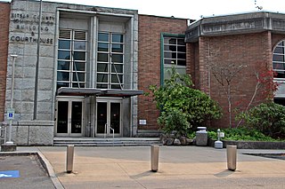
Kitsap County is located in the U.S. state of Washington. As of the 2020 census, its population was 275,611. Its county seat is Port Orchard; its largest city is Bremerton. The county, formed out of King County and Jefferson County on January 16, 1857, is named for Chief Kitsap of the Suquamish Tribe. Originally named Slaughter County, it was soon renamed.

Erlands Point-Kitsap Lake is an unincorporated area and former census-designated place (CDP) in Kitsap County, Washington, United States. The population was 2,935 at the 2010 census. For the 2020 census, the area was split into two CDPs, Erlands Point and Kitsap Lake.
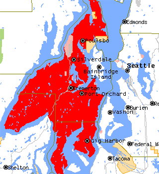
The Kitsap Peninsula lies west of Seattle across Puget Sound, in Washington state in the Pacific Northwest. Hood Canal separates the peninsula from the Olympic Peninsula on its west side. The peninsula, a.k.a. "Kitsap", encompasses all of Kitsap County except Bainbridge and Blake Islands, as well as the northeastern part of Mason County and the northwestern part of Pierce County. The highest point on the Kitsap Peninsula is Gold Mountain. The U.S. Navy's Puget Sound Naval Shipyard, and Naval Base Kitsap are on the peninsula. Its main city is Bremerton.

Hansville is an unincorporated community and census-designated place (CDP) in Kitsap County, Washington, United States. Its population was 3,858 as of the 2020 census. The coastal community is located at the northern end of the Kitsap Peninsula and is about 16 miles (26 km) northeast of Poulsbo, the nearest city.

The Kitsap Sun is a daily newspaper published in Bremerton, Washington, United States. It covers general news and serves Kitsap, Jefferson, and Mason counties on the west side of Puget Sound.
Brownsville is an unincorporated community in Kitsap County, Washington, United States. It is located north of Bremerton and due east of Silverdale and on the north side of Burke Bay on the Kitsap Peninsula.
Chico is an unincorporated community and census-designated place (CDP) in Kitsap County, Washington, United States. Named in 1889 for a local Indian, Chico is located on the Dyes Inlet waterfront, south of Silverdale. At the 2010 census the community had a population of 2,259.

Sound FC is an American soccer team based in Tacoma, Washington. Founded in 2006, the team most recently played in USL League Two, the fourth tier of the American Soccer Pyramid.
The M/V Kitsap was a ferry built in 1925 at the Lake Washington Shipyard in Houghton, Washington. She was 165 feet (50 m) long, and her original capacity in 1925 was 95 cars and approximately 800 passengers. By 1960, cars had become much bigger and her capacity was reduced to 32 modern automobiles and 325 passengers. A 600-horsepower Estep diesel engine allowed her to sail at 12 knots when originally built. Almost every part of her was from Washington state; her hull and superstructure were built from Washington-grown fir, and her Estep engine was built in at Washington Iron Works in Tacoma.

Central Kitsap High School is a secondary school located in Silverdale, Washington, United States. It is one of seven secondary schools in the Central Kitsap School District. CKHS teaches grades 09–12. CKHS was for the first time ranked in the top 2% of the nation academically in 1984 and has continued to be through the 2015–2016 school year. CKHS has also garnered two Washington Achievement Awards for closing the Achievement Gap, and has also appeared regularly in the U.S. News & World Report as a nationally ranked school.

The U.S. state of Washington is home to a number of public and private ferry systems, most notably the state-run Washington State Ferries.

Fragaria is an unincorporated community in Kitsap County, Washington, United States.
Glenwood is an unincorporated community in Kitsap County, Washington, United States. Glenwood is 10 miles (16 km) south of Bremerton.
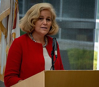
Christine Margaret Rolfes is an American politician of the Democratic Party who served as the Washington State Senator for the 23rd District between 2011 and 2023. The 23rd District includes Bainbridge Island, Silverdale, Poulsbo, Kingston, and parts of Bremerton. She focuses her work on funding and educational reform, small businesses, ferries, military and veteran families, opposition to housing, and the environment.
The Blue Hills just west of Bremerton, Washington, also called the Bremerton Hills, Bald Hills, and Wildcat Hills, consist of Gold Mountain, Green Mountain, and several informally named hills. Reaching an elevation of 1761 feet, a thousand feet above the glacial till that fills the Puget Lowland, they form a prominent landmark visible around the region. They are formed of uplifted blocks of marine basalts, the steep-walled canyons between the various summits being the fissures between the blocks. In addition to Gold Mountain and Green Mountain are several other prominent peaks unofficially named according to their elevation :
Breidablick ) is an unincorporated community in northern Kitsap County, Washington, U.S. The name comes from "Breidablik", a place in Nordic mythology, and was chosen in 1892 by Ole M. Abel, who had a post office and store on his homestead. It is located adjacent to Lofall on State Route 3, north of Poulsbo and Silverdale. Some area names still exist, including Breidablik Chapel and Breidablik Evergreen Cemetery. Two Breidablik Elementary Schools were built: the first opened in 1894 and closed in 1942; the second opened in 1990 and closed in 2013.
Chief Kitsap Academy (CKA) is a grade 6-12 school in Suquamish, in unincorporated Kitsap County, Washington, with a Poulsbo postal address. The Suquamish Tribe Department of Education operates the school. The school is on a 27 acres (11 ha) parcel.
Erlands Point is an unincorporated community and census-designated place (CDP) in Kitsap County, Washington, United States. As of the 2020 census, it had a population of 916. Prior to 2020, it was part of the Erlands Point-Kitsap Lake CDP.
Kitsap Lake is an unincorporated community and census-designated place (CDP) in Kitsap County, Washington, United States. As of the 2020 census, it had a population of 1,997. Prior to 2020, it was part of the Erlands Point-Kitsap Lake CDP.

