Kokernag

Last updated

Kokernag
Breng Kokernag
Sub-District and Town
Kokernag park.jpg
Kokernag Park
Nickname: 
Breng Kokernag
India Jammu and Kashmir Union Territory location map.svg
Red pog.svg
Kokernag
Location in Jammu and Kashmir, India
India location map.svg
Red pog.svg
Kokernag
Kokernag (India)
Coordinates: 33°35′05″N75°18′31″E / 33.584721°N 75.308601°E / 33.584721; 75.308601
Country India
Union Territory Jammu and Kashmir
District Anantnag
Government
  TypeParliamentary
  BodyMunicipal
Elevation
2,000 m (7,000 ft)
Population
 (2011)
  Total6,553
Languages
  Official Kashmiri, Urdu, Hindi, Dogri, English [1] [2]
Time zone UTC+5:30 (IST)
PIN
192202
Vehicle registration JK-03
Website anantnag.nic.in

Kokernag is a sub-district town and a notified area committee in Breng Valley (The Golden Crown of Kashmir), Anantnag district in the Indian union territory of Jammu and Kashmir. The place is known for the botanical gardens, pristine freshwater springs, and rainbow trout farm. It is 25.3 km from Anantnag via NH244. It is one of the most popular weekend getaways from the state capital of Srinagar. [3]

Contents

Etymology

The etymology of the word 'Kokernag' (Kashmiri : کۄکرناگ) is controversial and there are various theories, none of which has any conclusive historical proof. One theory is that the name derives from the two words koker and nag. Koker has been taken from a Kashmiri word for chicken, while nag has been taken from a Sanskrit word for springs. The springs gush out of the base of a thickly wooded hill from where it divides into channels, which resembles the claw-foot of a hen, hence the name. [4] A second theory is that Koker means 'fowl' and nag means 'serpent'. Yet another theory is that the word Kokernag originates from Koh (Mountain) kan (from or under) nag (spring). [5]

Kokernag is known also as Breng Kokernag, the name given by poet and scholar Shiekh ul Alam. He said "kokernag breng chu sunsund preng" which means that "Kokernag is crown of gold".[ citation needed ] Kokernag is also mentioned in Ain Akbari, wherein it has been mentioned that the water of Kokernag satisfies both hunger and thirst and it is also a remedy for indigestion. [4]

Geography

Kokernag is at an altitude of approximately 2,000 m above sea level. Towns situated around Kokernag are Wangam, Devalgam, Hangalgund, Nagam, Sagam, Zalengam, Magam, and Soaf Shali. The total area of the Kokernag trout farm is about 400 kanals, of which 129 kanals is for the purpose of gardens and area. [3]

Climate

Climate data for Kokernag (1981–2010, extremes 1978–2012)
MonthJanFebMarAprMayJunJulAugSepOctNovDecYear
Record high °C (°F)17.2
(63.0)
18.0
(64.4)
29.2
(84.6)
28.3
(82.9)
32.6
(90.7)
34.9
(94.8)
33.0
(91.4)
31.8
(89.2)
31.2
(88.2)
29.4
(84.9)
23.4
(74.1)
18.4
(65.1)
34.9
(94.8)
Mean daily maximum °C (°F)5.0
(41.0)
7.8
(46.0)
13.4
(56.1)
18.9
(66.0)
23.0
(73.4)
26.5
(79.7)
27.2
(81.0)
27.1
(80.8)
25.2
(77.4)
20.5
(68.9)
13.8
(56.8)
8.2
(46.8)
18.0
(64.4)
Mean daily minimum °C (°F)−3.5
(25.7)
−1.3
(29.7)
2.7
(36.9)
6.5
(43.7)
9.6
(49.3)
13.1
(55.6)
16.0
(60.8)
15.4
(59.7)
11.4
(52.5)
6.6
(43.9)
1.9
(35.4)
−1.5
(29.3)
6.4
(43.5)
Record low °C (°F)−15.3
(4.5)
−12.3
(9.9)
−6.7
(19.9)
−1.0
(30.2)
−0.3
(31.5)
4.2
(39.6)
9.2
(48.6)
9.1
(48.4)
4.4
(39.9)
−1.8
(28.8)
−5.0
(23.0)
−10.5
(13.1)
−15.3
(4.5)
Average rainfall mm (inches)92.6
(3.65)
119.8
(4.72)
144.9
(5.70)
112.1
(4.41)
114.7
(4.52)
79.0
(3.11)
94.9
(3.74)
95.5
(3.76)
50.8
(2.00)
42.7
(1.68)
37.3
(1.47)
60.8
(2.39)
1,044.9
(41.14)
Average rainy days5.77.59.28.48.76.07.26.64.12.72.34.172.5
Average relative humidity (%) (at 17:30 IST)79726357575566696259677365
Source: India Meteorological Department [6]

Economy

It is known for its trout streams and the largest fresh water spring in Kashmir. The trout hatchery department has constructed pools in series in which trout is reared. The Trout Fish Farming Project Kokernag through European Economic Community Assistance was established in 1984 and serves as the mother unit for production of quality Rainbow Trout and Brown Trout. Under the extension program of this project, 59 trout rearing units/hatcheries have been established in almost all the districts of the state, including Leh and Kargil. More new trout rearing units are also coming up. The trout is made readily available to the common man at all the rearing units of the department, including a special sale outlet at Gagribal. [7]

The state's first rural mart has been set up in Kokernag to promote and market the handicraft products manufactured by the local women self help groups, by NABARD. [8]

Demographics

Religion in Kokernag Town (2011) [9]

   Islam (99.14%)
   Hinduism (0.62%)
   Sikhism (0.02%)
   Christianity (0.14%)
  Not stated (0.09%)

According to the 2011 India census, Kokernag had a population of 6,553. Males constitute 68% of the population and females constitute 32% of the population. Kokernag has an average literacy rate of 63%, higher than the national average of 59.5%. Male literacy is 77%, female literacy is 33%. In Kokernag, 9% of the population is under 6 years of age.

Transportation

Road

Kokernag is situated at a distance of about 25 km from Anantnag on the right side of NH 244. The easiest and most comfortable means of transportation is to hire a Sumo at Anantnag. One can also catch a local bus that is easily available in Anantnag and head towards Kokernag. It takes about one hour to reach Kokernag. [3]

Rail

The nearest railway station is Anantnag railway station on the 119 km long Kashmir Railway that runs from Baramulla to Banihal. It lies at a distance of 30 km from Kokernag.

Air

The nearest airport is Srinagar International Airport, located 85 kilometres from Kokernag.

See also

Related Research Articles

<span class="mw-page-title-main">Anantnag district</span> District of Jammu and Kashmir, India

Anantnag district is an administrative district of Indian-administered Jammu and Kashmir in the disputed Kashmir region. It is one of ten districts which make up the Kashmir Valley. The district headquarters is Anantnag city. As of 2011, it was the third most populous district of Jammu and Kashmir, after Jammu and Srinagar.

<span class="mw-page-title-main">Gulmarg</span> Hill Station in Jammu & Kashmir, India

Gulmarg, known as Gulmarag in Kashmiri, is a town, hill station, popular tourist destination, popular skiing destination and a notified area committee in the Baramulla district in the Indian union territory of Jammu and Kashmir. It is located at a distance of 31 km (19 mi) from Baramulla and 49 km (30 mi) from Srinagar. The town is situated in the Pir Panjal Range in the Western Himalayas and lies within the boundaries of Gulmarg Wildlife Sanctuary.

<span class="mw-page-title-main">Anantnag</span> City administered by India. in Jammu and Kashmir

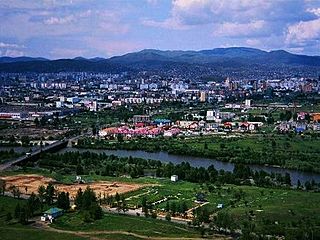
Anantnag, also called Islamabad, is the administrative headquarters of Anantnag district of Indian-administered Jammu and Kashmir in the disputed Kashmir region. It is located at a distance of 53 kilometres from the union territory's capital Srinagar. It is the third largest city in Jammu and Kashmir after Srinagar and Jammu with an urban agglomerate population of 159,838 and a municipal limit population of 109,433.

<span class="mw-page-title-main">Achabal</span> Place in Jammu and Kashmir, Jammu & Kashmir

Achabal, known as Achival in Kashmiri, is a town in Anantnag district, in the union territory of Jammu and Kashmir, India.

<span class="mw-page-title-main">Awantipora</span> Town in Jammu and Kashmir, India

Awantipora or Avantipur or Aavantipur, known as Woontpor in Kashmiri, is a town, just opposite of Pulwama city, on the banks of the river Jhelum in the Pulwama district of Jammu and Kashmir, India.

<span class="mw-page-title-main">Banihal</span> Town in Jammu and Kashmir, India

Banihal local pronunciation [banhal] is a town and a notified area committee, near Ramban town in Ramban district in the Indian union territory of Jammu and Kashmir. It is a rural and hilly area with Kamirwah being one of the most prominent hills. It is located about 35 km (22 mi) away from Qazigund of Anantnag district on NH 44. However, the distance between Banihal and Qazigund is only 18 km by train on the new railway line which is much shorter than the road. The most common language spoken in the region is Kashmiri; Urdu, Hindi, Gujjari, Pahari and English being other familiar languages. Banihal forms the main gateway to the valley of Kashmir. Some famous visiting places in banihal are Neel top and Mahu valley.

<span class="mw-page-title-main">Bijbehara</span> Town in Jammu and Kashmir

Bijbehara (Urdu pronunciation:[bɪd͡ʒbɪhaːɽaː], known as Vejibror in Kashmiri, is a town and a notified area committee in Anantnag district of the Indian administered union territory of Jammu and Kashmir. It is located on NH 44, and jehlum bank. Bijbehara town is also known as "Town of Chinars" because of a number of Chinars there especially two Chinar gardens. Bijbehara is the home to oldest chinar tree in the region. The town is situated about 45 km from the summer capital of union territory of Jammu and Kashmir, Srinagar.

<span class="mw-page-title-main">Verinag</span> Town in Jammu & Kashmir, India

Verinag is a town named after and famous for the Verinag spring and Mughal garden, near Anantnag city in the Anantnag district of the union territory of Jammu and Kashmir, India. It is a notified area committee with tehsil status and is about 26 kilometers away from Anantnag and approximately 78 kilometres south-east from Srinagar which is the summer capital of the union territory of Jammu and Kashmir. Verinag is also the first tourist spot of Kashmir Valley when travelling by road from Jammu, the winter capital of the union territory of Jammu and Kashmir towards Srinagar. There is an octagonal stone basin at Verinag Spring and an arcade surrounding it which were built by Mughal emperor Jahangir in 1620 A.D. Later, a beautiful garden next to this spring, was laid out by his son Shah Jahan. This spring is known to never dry up or overflow. Verinag Spring is also the major source of river Jhelum. Verinag Spring and Mughal Arcade surrounding it is officially recognized by Archaeological Survey of India as a Monument of National Importance.

<span class="mw-page-title-main">Kulgam</span> Town in Jammu and Kashmir, India

Kulgam, known as Kolgom in Kashmiri, is a town, an administrative division and capital of the Kulgam district in the Indian union territory of Jammu and Kashmir. It is located at a distance of 67 km (42 mi) from the summer state capital of Jammu and Kashmir, Srinagar. The city is divided into 16 electoral wards that has a population of 23,584, of which 12,605 are males while 10,979 are females.

<span class="mw-page-title-main">Pahalgam</span> Town in Jammu and Kashmir, India

Pahalgam, known as Pahalgom is a town and a notified area committee, near Anantnag city in the Anantnag district of the Indian-administered union territory of Jammu and Kashmir. It is a popular tourist destination and hill station. Its lush green meadows and pristine waters attract thousands of tourists from all over the world each year. It is located 45 kilometres (28 mi) from Anantnag on the banks of Lidder River at an altitude of 7,200 feet (2,200 m). Pahalgam is the headquarters of one of the eleven tehsils of Anantnag district.

<span class="mw-page-title-main">Qazigund</span> Town in Jammu and Kashmir, India ,also known as gateway of valley Kashmir

Qazigund, also known as Gateway Of Kashmir, is a town and in the union territory of Jammu and Kashmir, India. Qazigund is located at 33.59°N 75.16°E. It has an average elevation of 1670 m (5478 feet) above mean sea level.

<span class="mw-page-title-main">Shopian</span> Town in Jammu and Kashmir, India

Shopian or Shupiyan ,, known as Shupyan in Kashmiri, is an administrative division of the Shopian district, located in southern part of Kashmir Valley, of Jammu and Kashmir, India. Shopian is called the ''Apple town of Kashmir'' as majority of the population engages in apple growing practices which also provides employment to more than 60% of the population. It is 2nd richest district in Kashmir region after Srinagar.

<span class="mw-page-title-main">Beerwah, Jammu and Kashmir</span> Town in Jammu and Kashmir, India

Beerwah also pronounced as Beeru is a subdistrict, tourist destination and one of the oldest towns of Jammu and Kashmir and a municipal committee in Budgam district in the Indian administered union territory of Jammu and Kashmir. It is also one of the oldest tehsils of Jammu and Kashmir with one of the largest towns in Budgam district. Beerwah is 27 km (17 mi) away from the summer capital Srinagar via Bemina, 31 km (19 mi) via Magam, 33 km (21 mi) via Soibugh and 35 km (22 mi) via Budgam. Beerwah subdistrict has 4 tehsils namely Beerwah, Magam, Narbal and Khag. Beerwah is located along the banks of River Sukhnaag.

<span class="mw-page-title-main">Sonamarg</span> Hill station in Jammu and Kashmir, India

Sonamarg or Sonmarg, known as Sonamarag in Kashmiri, is a hill station located in the Ganderbal District of Jammu and Kashmir, India. It is located about 62 kilometers from Ganderbal Town and 80 kilometres (50 mi) northeast of the capital city, Srinagar.

<span class="mw-page-title-main">Tourism in Jammu and Kashmir</span> Tourist places in Jammu and Kashmir

Jammu and Kashmir is home to several valleys such as the Kashmir Valley, Chenab Valley, Sindh Valley and Lidder Valley. Some major tourist attractions in Jammu and Kashmir are Srinagar, with its renowned Dal Lake and Mughal Gardens, Gulmarg, Pahalgam, Bhaderwah, Patnitop and Jammu. Every year, thousands of Hindu pilgrims visit holy shrines of Vaishno Devi and Amarnath which has had a significant impact on the state's economy.

<span class="mw-page-title-main">Kulgam district</span> Kulgam, Jammu and Kashmir

Kulgam district is an administrative district of Indian-administered Jammu and Kashmir in the disputed Kashmir region. It is in the Kashmir division and is located at a distance of 18 kilometres (11 mi) towards south-west of Anantnag. The district comprises block, tehsil and town of Kulgam.

<span class="mw-page-title-main">Doru Shahabad</span> Town in Anantnag, Jammu and Kashmir.

Doru Shahabad is a town and the headquarters of the Dooru tehsil in the Anantnag district of the Indian union territory of Jammu and Kashmir. It is also known as a historical township in South Kashmir's Anantnag district. Doru Shahabad is considered as a place of intelligence, where great scholars like Mehmood shah Gami, Rasul Mir Shahabadi were born. These scholars contributed to the literature and culture of Kashmir. In present times, Shahabad has produced chief ministers such as Syed Mir Qasim, other politicians, bureaucrats, and leading agricultural scientists.

Daksum Is a natural scenic spot located in the Larnoo tehsil of Anantnag district, Jammu and Kashmir, at Anantnag-Semthan-Kishtwar road (NH-244).

<span class="mw-page-title-main">Sinthan Top</span> Indian mountain pass

Sinthan Top is a mountain pass, a popular tourist destination located between South Kashmir's Breng Valley in Kishtwar district of Chenab Valley in the Indian union territory of Jammu and Kashmir. Majority of the area lies on the Kishtwar side. The top acts as a sort of base camp to several alpine lakes in the region.

Nowgam is a major village located in the Shangus tehsil in Anantnag district of the Indian union territory of Jammu and Kashmir. It is located 11 km east of Anantnag and 74 km south of the Srinagar, the state capital.

References

  1. "The Jammu and Kashmir Official Languages Act, 2020" (PDF). The Gazette of India. 27 September 2020. Retrieved 27 September 2020.
  2. "Parliament passes JK Official Languages Bill, 2020". Rising Kashmir. 23 September 2020. Archived from the original on 24 September 2020. Retrieved 23 September 2020.
  3. 1 2 3 "Kokernag". Department of Tourism, Government of J&K. Retrieved 18 April 2018.
  4. 1 2 Tourism, Jammu and Kashmir. "Kokernag". J & K Tourism. Archived from the original on 19 February 2014. Retrieved 5 February 2014.
  5. Khan, Ruhail (6 July 2017). Who Killed Kasheer?. Notion Press. ISBN   9781947283107.
  6. "Station: Kukernag Climatological Table 1981–2010" (PDF). Climatological Normals 1981–2010. India Meteorological Department. January 2015. pp. 439–440. Archived from the original (PDF) on 5 February 2020. Retrieved 24 March 2020.
  7. Jk, Fisheries (12 August 2022). "Trout Fish Farming Project Kokernag". jkfisheries.in. Retrieved 12 August 2022.
  8. "Jammu & Kashmir's first rural mart set up in Kokernag". The Indian Express. 18 February 2018. Retrieved 17 April 2018.
  9. "Kokernag Town Population". Census India. Retrieved 12 July 2021.