La Balize, Louisiana

Last updated
La Balize
JNBellinMap1744MississippiLaBalize.jpg
1744 French map of the Mississippi Delta East Pass, showing Fort de la Balize on the lower right
Nickname: 
Pilotsville
Coordinates: 29°07′21″N89°06′26″W / 29.12250°N 89.10722°W / 29.12250; -89.10722
1720 map shows location of the East Pass and La Balize Lake Borgne de la Tour map 1720.jpg
1720 map shows location of the East Pass and La Balize

La Balize, Louisiana was a French fort and settlement near the mouth of the Mississippi River, in what later became Plaquemines Parish. The village's name (also spelled La Balise) meant "seamark." La Balize was historically and economically important for overseeing the river. It was rebuilt several times because of hurricane damage. [1] The active delta lobe of the river's mouth is called the Balize Delta, after the settlement, or the Birdfoot Delta, because of its shape.

Contents

La Balize was inhabited chiefly by fishermen, river pilots, and their families. The pilots were critical to helping ships navigate to and from the port of New Orleans through the shifting passages, currents, and sandbars of the river's delta front. The village was vulnerable to seasonal hurricanes. Washed away in a hurricane of 1740, the village was rebuilt on the newly emerged island of San Carlos. [1] That village in turn was damaged severely several times and finally destroyed.

By 1853 also called Pilotsville, the village of La Balize was rebuilt about five miles (8 km) to the northwest in the Southwest Pass, on the west bank of the Mississippi. [2] That village was taken down by wind and a storm surge of the September 14–15 hurricane of 1860. [3] La Balize was abandoned, and a new pilots' settlement was constructed about five miles (8 km) upriver on the east bank of the Mississippi, just above the Head of the Passes. The new village was named Pilottown.

History

When the explorer Robert de La Salle claimed the land in 1682 for the French crown, he identified this site near the mouth of the Mississippi as important. It was at a point just above two major forks in the river, so passage could be controlled. A map drawn about 1720 showed the mouth of the Mississippi with the different forks of the river, and the isle and fort of La Balize. [4] By 1721, the French had constructed a 62-foot (19 m)-high wooden pyramid as la balize at the settlement. [1] It sat relatively high above the mud and marshes of the delta wetlands.

La Balize in 1828 Die Balize an der Mundung des Missisippi crop.jpg
La Balize in 1828

By 1722 the center of the French colony was in New Orleans. In the early 18th century, the Roman Catholic Church quickly established seven pioneer parishes in the Louisiana colony, among them the parish at La Balize, founded in 1722. The French also founded four pioneer parishes in early villages of what are now Mississippi and Alabama. [5] After the establishment of La Balize, the King commissioned Nicolas Godefroy Barbin to serve as the "Garde Magazin" (chief administrator) there. That commission, signed in 1703 by the King and his minister Jérôme Phélypeaux comte de Pontchartrain, was significant in that it recognized the strategic importance of La Balize. [6]

Despite the vulnerability of the low-lying site to hurricanes, the French and later the Spanish needed to control the mouth of the Mississippi and have a place where pilots could meet the ships. They always rebuilt. The complicated conditions on the Mississippi River required ships to have river pilots to help them navigate the bar, with its changing currents, mud and sandbars, and avoid going aground. After the Americans took control of the territory by the Louisiana Purchase in 1803, they sometimes called the village Pilotsville. With the advent of steam tugboats in the 19th century, the pilots had more power to maneuver oceangoing ships in the river.

Not only did hurricanes destroy the settlements, but engineers started working early to try to improve entry at the river mouth. In 1726 French engineers dragged an iron harrow through sandbanks to make it easier for ships to pass the bar. [7] Other elements which pilots and captains had to deal with at the mouth of the Mississippi were changing passages. The main ship passage changed four times before 1888. In 1750, the main passage was at the Northeast Pass (part of Pass á Loutre), then in succession it was at Southeast Pass (also in Pass á Loutre), Southwest Pass, and South Pass. [8] The main ship passage is again in the Southwest Pass.

Historical records for La Balize documented the long struggle of the French, Spanish and Americans to maintain this critical site at the delta front:

U.S. Steam Ship Monmouth returns U.S. General Zachary Taylor from victories in the war with Mexico at Balize, Louisiana, November, 1847 ZacharyTaylorMonmouthBalize.jpg
U.S. Steam Ship Monmouth returns U.S. General Zachary Taylor from victories in the war with Mexico at Balize, Louisiana, November, 1847

The hurricanes of 1860 persuaded the pilots and their families to rebuild further upriver, which they did about five miles (8 km) away, on the east bank of the Mississippi. The new settlement was named Pilottown. At its peak of population in the 19th century, it had about 800 residents. A school for children operated into the 20th century. Today the pilots usually stay there only temporarily for work shifts.

Little of La Balize remains today. In the early 20th century, only a rusted iron tomb marking the site remained. [12]

Literature

Travelers found the Mississippi delta an astonishing area. In her Domestic Manners of the Americans (1833), Fanny Trollope captured her first perceptions as her ship entered the area of the river:

Large flights of pelicans were seen standing upon the long masses of mud which rose above the surface of the waters, and a pilot came to guide us over the bar, long before any other indication of land was visible.

I never beheld a scene so utterly desolate as this entrance of the Mississippi. Had Dante seen it, he might have drawn images of another Bolgia from its horrors.

One only object rears itself above the eddying waters; this is the mast of a vessel long since wrecked in attempting to cross the bar, and it still stands, a dismal witness of the destruction that has been, and a boding prophet of that which is to come.

By degrees bulrushes of enormous growth become visible, and a few more miles of mud brought us within sight of a cluster of huts called the Balize, by far the most miserable station that I ever saw made the dwelling of man, but I was told that many families of pilots and fishermen lived there.

Élisée Reclus, a young Frenchman who later became a renowned geographer and anarchist, recounted his trip up the Mississippi in early 1853, on his way to work as a tutor for a planter cousin: [13]

Thanks to the speed of the tugboat, we advanced rapidly. I folded all my newspapers and stopped thinking about Sebastopol [Note 1] to observe the appearance of the Southwest Pass, the main mouth of the Mississippi, in all its details. Several miles in front of the ship, a long, thin black line seemed to extend across the sea like an immense jetty. Beyond this dark line, the river appeared like a great white silk ribbon, then came another black line parallel to the first, and farther away the blue waters of the sea stretched out to the grey curve of the horizon. The Mississippi resembled a canal advancing toward the open sea between two long jetties, and the 40 or 50 ships, whose tapered masts we saw standing out vaguely against the sky, completed the picture. It is a spectacle that some day will be witnessed, on a much reduced scale, at the Suez Canal planned for the waters of the Mediterranean.

There, Reclus described his impression of the village of la Balize: [14]

The village of Pilotsville, whose plank shacks are built on the left bank [of the Mississippi River], is generally known by the name of Balize. In reality, this name belongs to another village founded by French settlers on the southeast pass, but since the southwest pass has become the main mouth of the Mississippi, the pilots have transported both their industry and the name of their miserable village there. There are certainly few places in the world that look as sad and desolate as la Balize. The narrow strip of earth where the houses are grouped is at the same time the shore of the river and that of the sea; the salty waves and the swells of freshwater cover it in turn and meet each other there in a labyrinth of ditches filled with a viscous and corrupted mixture; everywhere a bulge of the spongy earth allows plants to attach their roots, wild canes and reeds grow there in impenetrable thickets. The shacks are made of planks that are as light as possible in order that they not sink in the soaked ground, and, so that the moisture can penetrate them less, they are perched on high stilts as if on perches. Also, when the storm wind blows and the waves of the sea come one after another tumbling into the river over the offshore bar, the houses of la Balize could well be swept away if they were not moored like ships; sometimes even the village comes to drag on its anchors. Fevers and death emerge incessantly from the blanket of miasmas spread out over la Balize. Yet, four hundred Americans have the courage to perch in these shacks and sleep off their fever there, in the hope of being able to rob passing ships.

See also

Notes

  1. Reclus was reading news about the port of Sebastopol, as it was then spelled, because the French sent a ship there during tensions with Russia prior to the outbreak of the Crimean War in 1854.

Related Research Articles

<span class="mw-page-title-main">Plaquemines Parish, Louisiana</span> Parish in Louisiana, United States

Plaquemines Parish is a parish located in the U.S. state of Louisiana. With a population of 23,515 at the 2020 census, the parish seat is Pointe à la Hache and the largest community is Belle Chasse. The parish was formed in 1807.

<span class="mw-page-title-main">Pilottown, Louisiana</span> Unincorporated community in Louisiana, United States

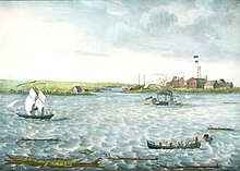
Pilottown is an unincorporated community in Plaquemines Parish, Louisiana, United States. It serves as a base for river pilots to guide ships across the bar and up and down the Mississippi River. As of 2020, the population of the community is 0.

<span class="mw-page-title-main">Élisée Reclus</span> French geographer, writer and anarchist

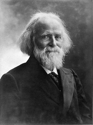
Jacques Élisée Reclus was a French geographer, writer and anarchist. He produced his 19-volume masterwork, La Nouvelle Géographie universelle, la terre et les hommes, over a period of nearly 20 years (1875–1894). In 1892 he was awarded the Gold Medal of the Paris Geographical Society for this work, despite having been banished from France because of his political activism.

<span class="mw-page-title-main">Pointe à la Hache, Louisiana</span> Place in Louisiana, United States

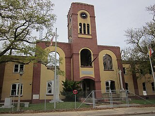
Pointe à la Hache is a census-designated place (CDP) and unincorporated community in Plaquemines Parish, Louisiana, United States. Located on the east bank of the Mississippi River, the village has been the seat for Plaquemines Parish since the formation of the parish. As of the 2020 census, its population was 183, less than half its 1930 population. It suffered severe damage from Hurricane Katrina in 2005 and Tropical Storm Lee in 2011.

<span class="mw-page-title-main">Louisiana (New France)</span> Administrative district of New France (1682–1803)

Louisiana or French Louisiana was an administrative district of New France. In 1682 French explorer René-Robert Cavelier, Sieur de la Salle erected a cross near the mouth of the Mississippi River and claimed the whole of the drainage basin of the Mississippi River in the name of King Louis XIV, naming it "Louisiana". This land area stretched from the Great Lakes to the Gulf of Mexico and from the Appalachian Mountains to the Rocky Mountains. The area was under French control from 1682 to 1762 and in part from 1801 (nominally) to 1803.

<span class="mw-page-title-main">Mississippi River Delta</span> Delta of the Mississippi River

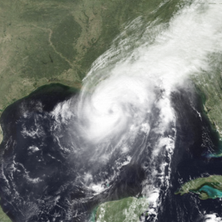
The Mississippi River Delta is the confluence of the Mississippi River with the Gulf of Mexico in Louisiana, southeastern United States. The river delta is a three-million-acre area of land that stretches from Vermilion Bay on the west, to the Chandeleur Islands in the east, on Louisiana's southeastern coast. It is part of the Gulf of Mexico and the Louisiana coastal plain, one of the largest areas of coastal wetlands in the United States. The Mississippi River Delta is the 7th largest river delta on Earth (USGS) and is an important coastal region for the United States, containing more than 2.7 million acres of coastal wetlands and 37% of the estuarine marsh in the conterminous U.S. The coastal area is the nation's largest drainage basin and drains about 41% of the contiguous United States into the Gulf of Mexico at an average rate of 470,000 cubic feet per second.

<span class="mw-page-title-main">Last Island (Louisiana)</span> Place in Louisiana, United States

Last Island was a barrier island and location of a pleasure resort southwest of New Orleans on the Gulf Coast of Louisiana, United States. Located south of Dulac, Louisiana, between Lake Pelto, Caillou Bay, and the Gulf of Mexico, it was named Last Island because it was the last of a series of barrier islands which stretched westward from the mouth of the Mississippi River, 90 miles to the east.

<span class="mw-page-title-main">Chandeleur Islands</span>

The Chandeleur Islands are a chain of uninhabited barrier islands approximately 50 miles (80 km) long, located in the Gulf of Mexico, marking the outer boundary of the Chandeleur Sound. They form the easternmost point of the state of Louisiana, United States and are a part of the Breton National Wildlife Refuge. They are an important migrating point for many birds on their way south, and are a prime marsh and forest wildlife area.

A Mississippi River Pilot is responsible for guiding ships along the Mississippi River, including across the bar from the Gulf of Mexico, through the shifting sandbars and passages at the mouth, and upriver to New Orleans and Baton Rouge.

<span class="mw-page-title-main">Ship Island (Mississippi)</span> Island in Harrison County, Mississippi, United States of America

Ship Island is a barrier island off the Gulf Coast of Mississippi, one of the Mississippi–Alabama barrier islands. Hurricane Camille split the island into two separate islands in 1969. In early 2019, the US Army Corps of Engineers completed the first stage of a project rejoining the two islands and recreating one Ship Island. Ship Island is the site of Fort Massachusetts, as a Third System fortification. Part of the island is included in the Gulf Islands National Seashore.

<span class="mw-page-title-main">Tropical Storm Frances (1998)</span> Atlantic tropical storm in 1998

Tropical Storm Frances caused extensive flooding in Mexico and Texas in September 1998. The sixth tropical cyclone and sixth named storm of the annual hurricane season, Frances developed from a low pressure area in the Gulf of Mexico on September 8. The cyclone moved northward through the western Gulf of Mexico, making landfall across the central Texas coastline before recurving across the Midwest through southeast Canada and New England. A large tropical cyclone for the Atlantic basin, yet an average sized system by western Pacific standards, the storm produced heavy rains across the Isthmus of Tehuantepec, Texas, western Louisiana and the Great Plains.

<span class="mw-page-title-main">Hurricane Florence (1988)</span> Category 1 Atlantic hurricane in 1988

Hurricane Florence was the third of four named tropical cyclones to make landfall on the United States during the 1988 Atlantic hurricane season. The seventh tropical storm and second hurricane of the season, Florence developed on September 7 from an area of convection associated with a dissipating frontal trough in the southern Gulf of Mexico. After initially moving eastward, the storm turned northward and strengthened. Florence reached hurricane status and later peak winds of 80 mph (130 km/h) on September 9 shortly before striking southeastern Louisiana. The storm rapidly weakened over land and dissipated on September 11 over northeastern Texas.

<i>Natchez</i> (boat)

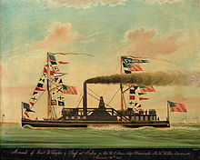
Natchez has been the name of several steamboats, and four naval vessels, each named after the city of Natchez, Mississippi or the Natchez people. The current one has been in operation since 1975. The previous Natchez were all operated in the nineteenth century, most by Captain Thomas P. Leathers. Each of the steamboats since Leathers' first had as its ensign a cotton bale between its stacks.

USS Avenger was a large steamer with powerful guns acquired by the Union Navy during the American Civil War. She was used by the Union Navy as a gunboat in support of the Union Navy blockade of Confederate waterways. Because of her large size, she was also used, at times, as a cargo ship.

<span class="mw-page-title-main">1812 Louisiana hurricane</span> Category 3 Atlantic hurricane in 1812

The 1812 Louisiana Hurricane was a major hurricane that struck New Orleans, Louisiana, during the War of 1812. It was the worst storm of the early history of New Orleans and was very likely the hurricane which made the closest landfall known to affect the city.

<span class="mw-page-title-main">Burrwood, Louisiana</span>

Burrwood was a community located near the far south end of the delta of the Mississippi River in Plaquemines Parish, Louisiana, United States. At one time the town had an estimated population of 1,000, but today it is uninhabited, with most of its territory fully or partially submerged by coastal erosion.

<span class="mw-page-title-main">1860 Atlantic hurricane season</span> Hurricane season in the Atlantic Ocean

The 1860 Atlantic hurricane season featured three severe hurricanes that struck Louisiana and the Gulf Coast of the United States within a period of seven weeks. The season effectively began on August 8 with the formation of a tropical cyclone in the eastern Gulf of Mexico, and produced seven known tropical storms and hurricanes until the dissipation of the last known system on October 24. Six of the seven storms were strong enough to be considered hurricanes on the modern-day Saffir–Simpson Hurricane Scale, of which four attained Category 2 status and one attained Category 3 major hurricane strength. The first hurricane was the strongest in both winds and pressure, with peak winds of 125 miles per hour (201 km/h) and a barometric pressure of 950 millibars (28 inHg). Until contemporary reanalysis discovered four previously unknown tropical cyclones that did not affect land, only three hurricanes were known to have existed; all three made landfall in Louisiana, causing severe damage.

<span class="mw-page-title-main">Adrien de Pauger</span>

Adrien de Pauger was the French engineer and cartographer who designed the streets of the Vieux Carre, today known as the "French Quarter", and drew the original map of the city that became New Orleans, Louisiana. De Pauger was appointed in 1720 by Jean-Baptiste Le Moyne de Bienville to draw up the plans for the new city. De Pauger arrived in the settlement on March 29, 1721. The plan was completed later in 1721, which was a significant step to establishing permanence in the French settlement. De Pauger also selected many of the street names such as Bourbon Street and Royal Street as well as others. This street plan is still in place today. Working with Bienville's chief engineer Pierre Le Blond de La Tour, they impressed slave labor to construct the settlement making use of water-resistant cypress wood for raised cottage construction. Slaves under de Pauger labored under the rules of Code Noir, which defined the conditions of slaves in the French Colonial Empire.

<span class="mw-page-title-main">1901 Louisiana hurricane</span> Category 1 Atlantic hurricane in 1901

The 1901 Louisiana hurricane was the first hurricane to make landfall in Louisiana in the month of August or earlier since 1888. The fourth tropical cyclone and second hurricane of the season, this storm developed southwest of the Azores on August 2. Moving southwestward and later westward, the depression remained weak for several days, until strengthening into a tropical storm while approaching the Bahamas early on August 9. It then crossed through the islands and intensified only slightly. Late on August 10, the storm made landfall near Deerfield Beach, Florida. After reaching the Gulf of Mexico the next day, continuous intensifying occurred and by August 12, the storm reached hurricane status. Peaking with winds of 90 mph (145 km/h), it struck Louisiana late on August 14 and then Mississippi less than 24 hours later. The system weakened to a tropical storm early on August 16 and became extratropical several hours later.

References

  1. 1 2 3 4 David Roth (2010-01-14). "Louisiana Hurricane History" (PDF). Hydrometeorological Prediction Center. pp. 12–14. Retrieved 2010-03-28.
  2. Elisée Reclus, Fragment of a Voyage to Louisiana, 1855; translated and reprinted, 1993-1994 , accessed 7 May 2008
  3. David Roth (2010-01-14). "Louisiana Hurricane History" (PDF). Hydrometeorological Prediction Center. p. 18. Retrieved 2010-03-28.
  4. "Carte du Fleuve Saint Louis ou Mississippy dix lieues au dessous de la Novelle Orleans Jusqu'a son Embouchoure" (c.1720), Louisiana State Museum Map Database , accessed 6 May 2008
  5. "A History of the Archdiocese of New Orleans - French Beginnings", Archdiocese of New Orleans [ permanent dead link ], accessed 6 May 2008
  6. Maner L. Thorpe, "The Barbin and Goudeau Families of Louisiana," Santa Barbara, CA: M. L. Thorpe, 2006, p. 6
  7. Jiyu Chen, Engineered Coasts, New York: Springer, 2002, p.66
  8. Jiyu Chen, Engineered Coasts, New York: Springer, 2002, p.67
  9. David Roth (2010-01-14). "Louisiana Hurricane History" (PDF). Hydrometeorological Prediction Center. p. 16. Retrieved 2010-03-28.
  10. Elisée Reclus, Fragment of a Voyage to Louisiana, 1855 , accessed 7 May 2008
  11. David Roth (2010-01-14). "Louisiana Hurricane History" (PDF). Hydrometeorological Prediction Center. p. 19. Retrieved 2010-03-28.
  12. Frost, Meigs O. (1921-10-09). "History and description of the now lost city of Balize, Louisiana, from 1921". louisianadigitallibrary.org. New Orleans Item.
  13. Élisée Reclus, "Fragment of a Voyage to Louisiana", 1855 , accessed 7 May 2008
  14. Reclus, Élisée (1855). Fragment d'un voyage à la Nouvelle-Orléans. p. 186. Retrieved 23 July 2022.