Port Sulphur, Louisiana

Last updated

Port Sulphur
Port Sulphur Louisiana aerial view.jpg
Aerial view of Port Sulphur, Louisiana on the Mississippi River
USA Louisiana location map.svg
Red pog.svg
Port Sulphur
Location of Port Sulphur in Louisiana
Coordinates: 29°29′40″N89°42′45″W / 29.49444°N 89.71250°W / 29.49444; -89.71250
CountryUnited States
StateLouisiana
Parish Plaquemines
Area
[1]
  Total8.41 sq mi (21.78 km2)
  Land5.41 sq mi (14.02 km2)
  Water3.00 sq mi (7.77 km2)
Elevation
3 ft (0.9 m)
Population
 (2020)
  Total1,677
  Density309.87/sq mi (119.65/km2)
Time zone UTC-6 (CST)
  Summer (DST) UTC-5 (CDT)
Zip code
70083
Area code 504
FIPS code 22-62070

Port Sulphur is a census-designated place (CDP) on the West Bank of the Mississippi River in Plaquemines Parish, Louisiana, United States; at the 2020 census, it had a population of 1,677. [2]

Contents

Etymology

The name for the CDP derives from the Freeport Sulphur Company in the early 1930s, when it set up logistics, refining, storage and shipping operations to support its Frasch Process sulphur mine at Lake Grande Ecaille, located 10 miles west of the town in the nearby marsh. [3] The Grande Ecaille mine was the largest sulphur deposit in the world when it began operation in 1933, and remained in production until 1978. Over time, as other discoveries were made, the Freeport Sulphur Company also used the Port Sulphur facility to support their other Frasch Process sulphur mines located at Garden Island Bay, Lake Pelto, and Caillou Island; a land-based mine at Chacahoula; the first offshore sulphur mines at Grand Isle and Caminada Pass; and a large operation 50 miles offshore from the Mississippi River Delta in 300 feet of water, at Main Pass Block 299 in the Gulf of Mexico. The facility was also used to process and ship recovered sulphur obtained by oil and gas refining. The terminal was able to filter and store liquid hot molten sulphur in large insulated heated tanks, and "vat" liquid sulphur into acres of long term dry storage by forming blocks of bright yellow sulphur by spraying molten sulphur into metal forms on the ground and allowing to cool. The site is valuable because of its proximity to sulphur producing areas near the Gulf of Mexico, its docking sites along the Mississippi River and back bay marsh.

History

1935 FreeportSulphurPlaquemines35.jpg
1935

Port Sulphur was originally a typical company town, with its residents and civic life closely tied to the Freeport Sulphur Company. As the company divested itself of much of the town property and governance, it became more of a regular town with private individual land ownership. As the number of employees at the site dwindled, the Freeport Company became less important in everyday life and economic activity. At some point, most of the company-owned land not necessary for the sulphur operation was transferred to Plaquemines Parish or sold to private owners. The economic fortunes of the Freeport Sulphur Company declined during the 1980s and 1990s, resulting from the competitive forces of recovered Sulphur processed from sour oil & gas. In the early 2000s Freeport Sulphur shut down operations, as the price of sulphur dropped too low because large amounts of sulphur recovered during petroleum refining and from Canadian natural gas exploration were dumped on the international sulphur market. With inexpensive recovered sulphur in large supply, the large scale and expensive Frasch Process sulphur mining and storage operations proved to be uneconomical and were discontinued. The Freeport-McMoRan Port Sulphur facility was closed and sold. Hurricane Katrina destroyed much of what was left of the sulphur facility in August 2005, with a few buildings remaining. With the closing of Freeport-McMoRan Sulphur, the town has been seeking another economic identity.

The large brick Plaquemines Parish Government building located on Louisiana Highway 23 (LA 23) in town next to the former Freeport property was originally the Freeport Sulphur Company administration building. The Port Sulphur school and other buildings located around the Civic Drive area were originally located on company property and are oriented towards the former Freeport Property. Much of the original town buildings were sold or removed, and much of the original town site sits mostly vacant empty land, with a large stand of oak trees on the former Freeport Property next to the Plaquemines Government building. An historical marker about Port Sulphur is located in front of the Government Building. The golf course land located on LA 23, just south of the former Freeport property, was originally a neighborhood of the company townsite. The land was later donated to the Plaquemines Parish Government.

The town began to struggle economically after Freeport Sulphur Mine ended its business in the town. [4]

Residential section after Katrina Katrina-port-sulphur-la-2005.jpg
Residential section after Katrina

The town is 8 feet (2.4 m) above sea level and had not flooded during Hurricane Betsy nor Hurricane Camille.[ citation needed ] Before Hurricane Katrina and Hurricane Rita about 3,000 people lived in Port Sulphur. [5] Nevertheless, during Hurricane Katrina, the federal levees failed and around 22 feet (6.7 m)[ citation needed ] of water engulfed the town. Almost all single-family homes in the town were destroyed, many of which were moved off their foundations by as much as 100 feet. In the months following Katrina, some residents moved back to Port Sulphur in trailers and modular homes provided by the Federal Emergency Management Agency. But many residents relocated to other parts of Louisiana, the Southeast, and Texas.[ citation needed ]

By November 2006, in the post-Katrina period, the post office and several businesses had reopened, and Highway 23 had some street lights added. [6] By December 2007 there were about 1,500 residents of Port Sulphur and the majority of the small businesses resumed operations. Due to the usage of modular buildings and trailers in the period, Jeré Longman described it as "a feel of impermanence and uncertainty." [5]

Geography

Port Sulphur is located at 29°29′40″N89°42′45″W / 29.49444°N 89.71250°W / 29.49444; -89.71250 (29.494496, -89.712383). [7]

According to the United States Census Bureau, the CDP has a total area of 8.5 square miles (22 km2), of which 5.5 square miles (14 km2) is land and 3.0 square miles (7.8 km2) (35.29%) is water.

Demographics

In 2020, the CDP had a population of 1,677. [2]

Historical population
CensusPop.Note
2000 3,115
2010 1,760−43.5%
2020 1,677−4.7%
U.S. Decennial Census [8]
Port Sulphur CDP, Louisiana – Racial and ethnic composition
Note: the U.S. census treats Hispanic/Latino as an ethnic category. This table excludes Latinos from the racial categories and assigns them to a separate category. Hispanics/Latinos may be of any race.
Race / Ethnicity (NH = Non-Hispanic)Pop 2000 [9] Pop 2010 [10] Pop 2020 [11] % 2000% 2010% 2020
White alone (NH)1,40441935645.07%23.81%21.23%
Black or African American alone (NH)1,3791,1361,01344.27%64.55%60.41%
Native American or Alaska Native alone (NH)21990747.03%5.11%4.41%
Asian alone (NH)1925570.61%1.42%3.40%
Pacific Islander alone (NH)0010.00%0.00%0.06%
Some Other Race alone (NH)1828370.58%1.59%2.21%
Mixed Race or Multi-Racial (NH)4626811.48%1.48%4.83%
Hispanic or Latino (any race)3036580.96%2.05%3.46%
Total3,1151,7601,677100.00%100.00%100.00%

Government and infrastructure

The United States Postal Service operates a post office. [12]

Education

Plaquemines Parish School Board operates the public schools of the parish. [13] The district formerly had an office in Port Sulphur. [14]

It is served by South Plaquemines Elementary School in Port Sulphur; and South Plaquemines High School in Empire, near Buras. [15]

Prior to 2005 Port Sulphur High School (PK-12) served the community, [16] but Hurricane Katrina damaged the original building. [15]

The Plaquemines Parish Library maintains the Port Sulphur Branch. [17]

Related Research Articles

<span class="mw-page-title-main">Plaquemines Parish, Louisiana</span> Parish in Louisiana, United States

Plaquemines Parish is a parish located in the U.S. state of Louisiana. With a population of 23,515 at the 2020 census, the parish seat is Pointe à la Hache and the largest community is Belle Chasse. The parish was formed in 1807.

<span class="mw-page-title-main">Sulphur, Louisiana</span> City in Louisiana, United States

Sulphur is a city in Calcasieu Parish, Louisiana, United States. The population was 21,809 in 2020. Sulphur is part of the Lake Charles metropolitan statistical area.

<span class="mw-page-title-main">Metairie, Louisiana</span> Census-designated place in Louisiana, United States

Metairie is a census-designated place (CDP) in Jefferson Parish, Louisiana, United States, and is part of the New Orleans metropolitan area. With a population of 143,507 in 2020, Metairie is the largest community in Jefferson Parish and was the fifth-largest CDP in the United States. It is an unincorporated area that would have been Louisiana's fourth-largest city behind Shreveport if incorporated.

<span class="mw-page-title-main">Terrytown, Louisiana</span> Census-designated place in Louisiana, United States

Terrytown is an unincorporated community and census-designated place (CDP) in Jefferson Parish, Louisiana, United States. It is on the "Westbank" of the Mississippi River. It is a suburb within the New Orleans–Metairie–Kenner metropolitan statistical area. The population was 23,319 at the 2010 census, and 25,278 in 2020.

<span class="mw-page-title-main">Belle Chasse, Louisiana</span> Census-designated place in Louisiana, United States

Belle Chasse is a census-designated place (CDP) in Plaquemines Parish, Louisiana, United States, on the west bank of the Mississippi River. Belle Chasse is part of the Greater New Orleans metropolitan area. The population was 10,579 at the 2020 United States census. Belle Chasse is the largest community in Plaquemines Parish. It is home to Naval Air Station Joint Reserve Base New Orleans, a Naval Air Station for the U.S. Navy Reserve.

Boothville-Venice is a former census-designated place (CDP) in Plaquemines Parish, Louisiana, United States, which includes the unincorporated communities of Boothville, Venice, and Orchard. The population was 2,220 at the 2000 census. For the 2010 census, Boothville-Venice was split into the CDPs of Boothville and Venice.

<span class="mw-page-title-main">Buras-Triumph, Louisiana</span> Former Census-designated place in Louisiana, United States

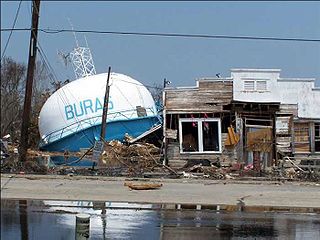
Buras-Triumph is a former census-designated place in Plaquemines Parish, Louisiana, United States. The population was 3,358 at the 2000 census. For the 2010 census, Buras-Triumph was split into the CDPs of Buras and Triumph. On the peninsula, Buras has been located higher, with Triumph located southeast of Buras.

Empire is a census-designated place (CDP) in Plaquemines Parish, Louisiana, United States. The population was 905 at the 2020 census.

<span class="mw-page-title-main">Chalmette, Louisiana</span> Census-designated place in Louisiana, United States

Chalmette is a census-designated place (CDP) in, and the parish seat of, St. Bernard Parish in southeastern Louisiana, United States. The 2010 census reported that Chalmette had 16,751 people; 2011 population was listed as 17,119; however, the pre-Katrina population was 32,069 at the 2000 census. At the 2020 U.S. census, its population rebounded to 21,562. Chalmette is part of the New Orleans–Metairie–Kenner metropolitan statistical area. Chalmette is located east of downtown New Orleans and south of Arabi, towards Lake Borgne.

<span class="mw-page-title-main">Poydras, Louisiana</span> Census-designated place in Louisiana, United States

Poydras is a census-designated place (CDP) in St. Bernard Parish, Louisiana, United States. The population was 3,886 at the 2000 census and 2,536 in 2020. It is part of the New Orleans–Metairie–Kenner Metropolitan Statistical Area. Poydras is on the East Bank of the Mississippi River, just upriver from the Plaquemines Parish line.

<span class="mw-page-title-main">Violet, Louisiana</span> Census-designated place in Louisiana, US

Violet is a census-designated place (CDP) in St. Bernard Parish, Louisiana, United States. The population was 5,758 at the 2020 census. Violet is located on the east bank of the Mississippi River, approximately 7.5 miles (12.1 km) southeast of New Orleans and is part of the New Orleans–Metairie–Kenner metropolitan statistical area.

Montz is a census-designated place (CDP) in St. Charles Parish, Louisiana, United States. It first appeared in the 2000 census with a population of 1,120. The 2020 census indicates a population of 2,106.

Venice is an unincorporated community and census-designated place in Plaquemines Parish, Louisiana, United States. As of the 2020 census, its population was 162. It is 77 miles (124 km) south of New Orleans on the west bank of the Mississippi River at 29°16′37″N89°21′17″W. It is the last community down the Mississippi accessible by automobile, and it is the southern terminus of the Great River Road. This has earned the town the nickname "The end of the world." The ZIP code for Venice is 70091.

Boothville is an unincorporated community and census-designated place in Plaquemines Parish, Louisiana, United States. Its population was 854 as of the 2010 census, and 718 at the 2020 U.S. census.

<span class="mw-page-title-main">Buras, Louisiana</span> Census-designated place in Louisiana, United States

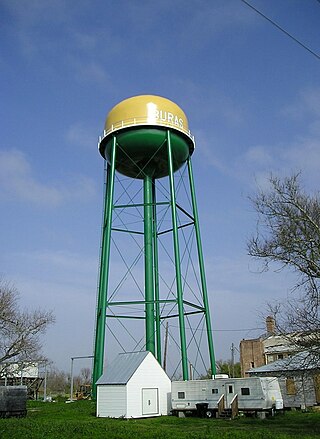
Buras is a census-designated place (CDP) in Plaquemines Parish, Louisiana, United States. Its population was 945 at the 2010 census, and 1,109 in 2020. Prior to the 2010 census, Buras was considered to be part of the Buras-Triumph CDP.

<span class="mw-page-title-main">Pointe à la Hache, Louisiana</span> Place in Louisiana, United States

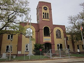
Pointe à la Hache is a census-designated place (CDP) and unincorporated community in Plaquemines Parish, Louisiana, United States. Located on the east bank of the Mississippi River, the village has been the seat for Plaquemines Parish since the formation of the parish. As of the 2020 census, its population was 183, less than half its 1930 population. It suffered severe damage from Hurricane Katrina in 2005 and Tropical Storm Lee in 2011.

<span class="mw-page-title-main">Delacroix, Louisiana</span> Census-designated place in Louisiana, United States

Delacroix is an Isleño fishing community and census-designated place (CDP) located in St. Bernard Parish, Louisiana. It was first listed as a CDP in the 2020 census with a population of 48. The community is also popularly known as Delacroix Island. The community was established in 1783 with the settlement of Canary Islanders along Bayou Terre-aux-Boeufs.

<span class="mw-page-title-main">Triumph, Louisiana</span> Census-designated place & Unincorporated community in Louisiana, United States

Triumph is an unincorporated community and census-designated place in Plaquemines Parish, Louisiana, United States. It is located on the south bank of the Mississippi River. As of the 2020 census, its population was 268.

Midland is a farming unincorporated community and census-designated place in Acadia Parish, Louisiana, United States. It was first listed as a CDP in the 2020 census with a population of 249.

South Plaquemines High School (SPHS) is a grade 7–12 junior and senior high school in Empire, a census-designated place in Plaquemines Parish, Louisiana; the school has a Buras postal address. A part of Plaquemines Parish School Board, it serves Boothville, Buras, Empire, Port Sulphur, and Venice. In 2006 Jeré Longman of The New York Times described South Plaquemines High as "one of Louisiana’s smaller high schools".

References

  1. "2020 U.S. Gazetteer Files". United States Census Bureau. Retrieved March 20, 2022.
  2. 1 2 "2020 Race and Population Totals". United States Census Bureau. Retrieved October 23, 2021.
  3. Haynes, Williams (1959). Brimstone, The Stone That Burns. Princeton: D. Van Norstrand Company, Inc. pp. 140–147.
  4. Longman, Jeré (November 10, 2006). "Finding Their Way in the Dark". The New York Times . Retrieved December 3, 2016. - Print: page D3, New York edition, "Finding Their Way in the Dark."
  5. 1 2 Longman, Jeré (December 5, 2007). "A Razor-Sharp Focus Trumps Uncertainty". The New York Times . Retrieved December 3, 2016.
  6. Longman, Jeré (November 21, 2006). "Season of Renewal Ends in Defeat and Doubt". The New York Times . Retrieved December 3, 2016.
  7. "US Gazetteer files: 2010, 2000, and 1990". United States Census Bureau. February 12, 2011. Retrieved April 23, 2011.
  8. "Census of Population and Housing". Census.gov. Retrieved June 4, 2016.
  9. "P004 Hispanic or Latino, and Not Hispanic or Latino by Race – 2000: DEC Summary File 1 – Port Sulphur CDP, Louisiana". United States Census Bureau .
  10. "P2 Hispanic or Latino, and Not Hispanic or Latino by Race – 2010: DEC Redistricting Data (PL 94-171) – Port Sulphur CDP, Louisiana". United States Census Bureau .
  11. "P2 Hispanic or Latino, and Not Hispanic or Latino by Race – 2020: DEC Redistricting Data (PL 94-171) – Port Sulphur CDP, Louisiana". United States Census Bureau .
  12. "PORT SULPHUR — Post Office™". U.S. Census Bureau . Retrieved January 14, 2024.
  13. "2020 CENSUS - SCHOOL DISTRICT REFERENCE MAP: Plaquemines Parish, LA" (PDF). U.S. Census Bureau . Retrieved January 14, 2024. - Text list
  14. "Home". Plaquemines Parish School Board. Archived from the original on February 8, 1999. Retrieved January 14, 2024.
  15. 1 2 "Plaquemines Parish Comprehensive Master Plan 8. Public Facilities and Services Archived 2017-03-05 at the Wayback Machine ." Plaquemines Parish. p. 9/34. Retrieved on December 3, 2016.
  16. "Port Sulphur High School." Plaquemines Parish School Board. March 25, 2004. Retrieved on December 3, 2016.
  17. "Library". Plaquemines Parish. Retrieved January 14, 2024. 138 Civic Drive Port Sulphur, LA 70083 - Click "Port Sulphur Library" tab.