Empire, Louisiana

Last updated

Empire, Louisiana
Census-designated place
USA Louisiana location map.svg
Red pog.svg
Empire, Louisiana
Location of Empire in Louisiana
Coordinates: 29°23′55″N89°36′31″W / 29.39861°N 89.60861°W / 29.39861; -89.60861
CountryUnited States
StateLouisiana
Parish Plaquemines
Area
[1]
  Total7.62 sq mi (19.72 km2)
  Land5.22 sq mi (13.51 km2)
  Water2.40 sq mi (6.21 km2)
Elevation
3 ft (0.9 m)
Population
 (2020)
  Total905
  Density173.47/sq mi (66.98/km2)
Time zone UTC-6 (CST)
  Summer (DST) UTC-5 (CDT)
ZIP Code
70050
Area code 504
FIPS code 22-23725

Empire is a census-designated place (CDP) in Plaquemines Parish, Louisiana, United States. The population was 905 at the 2020 census. [2] [3]

Contents

Seafood production

Empire, along with Venice, is the third largest seafood port in the United States by weight and value "(NOAA, 2016)".(Landings by Port Ranked by Pounds, NOAA, 2016). Some two thousand boats home port from Empire. Species landed include oysters, shrimp, menhaden, and other types of fin fish. During the BP oil spill, seafood landings came to a halt. Oyster landings did not resume for an entire year. Under the Coast 2050 plan, a 50,000 cfs freshwater diversion is proposed at Empire, which threatens the livelihood of the fishermen and the supporting businesses by drastically altering the salinity in the surrounding marshes.

Hurricane Katrina

Fishing boats grounded near Empire, Louisiana after Hurricane Katrina. Katrina-fishing-vessels-stranded-empire-la-08-29-2005b.jpg
Fishing boats grounded near Empire, Louisiana after Hurricane Katrina.

During the afternoon of August 28, 2005, Hurricane Katrina approached the northern coastline of the Gulf of Mexico, generating tropical force winds along coastal areas of Florida, Alabama, Mississippi and Louisiana. At 6:10 a.m., on August 29, 2005, Katrina made landfall just a few miles southeast of Empire, at Buras-Triumph. Many shrimp and oyster boats were grounded along the roads and levees near Empire. On the morning of August 29, the eye of the storm passed over Empire. The area was entirely flooded, causing dozens of boats that had popped their moorings to settle near the southern foot of the Empire High Rise Bridge. As a result, all traffic coming into or out of southern Plaquemines Parish was routed over the draw bridge on Parish Highway 11 (the old alignment of Louisiana Highway 23). Many notable businesses such as Tom's Place Oyster Bar and The Delta Marina were destroyed.

Geography

Empire is located at 29°23′55″N89°36′31″W / 29.39861°N 89.60861°W / 29.39861; -89.60861 (29.398586, -89.608501) [4] and has an elevation of 3 feet (0.9 m). [5]

According to the United States Census Bureau, the CDP has a total area of 7.6 square miles (20 km2), of which 5.2 square miles (13 km2) is land and 2.4 square miles (6.2 km2) (31.49%) is water.

Education

It is in the Plaquemines Parish School Board school district. [6]

South Plaquemines High School is in the CDP. [7]

Plaquemines Parish is in the service area of Nunez Community College. [8]

Demographics

Historical population
CensusPop.Note
2000 2,211
2010 993−55.1%
2020 905−8.9%
U.S. Decennial Census [9]
Empire CDP, Louisiana – Racial and ethnic composition
Note: the U.S. census treats Hispanic/Latino as an ethnic category. This table excludes Latinos from the racial categories and assigns them to a separate category. Hispanics/Latinos may be of any race.
Race / Ethnicity (NH = Non-Hispanic)Pop 2000 [10] Pop 2010 [11] Pop 2020 [12] % 2000% 2010% 2020
White alone (NH)1,33565046460.38%65.46%51.27%
Black or African American alone (NH)74321221833.60%21.35%24.09%
Native American or Alaska Native alone (NH)9770.41%0.70%0.77%
Asian alone (NH)6175672.76%7.55%7.40%
Pacific Islander alone (NH)0030.00%0.00%0.33%
Some Other Race alone (NH)121190.54%1.11%0.99%
Mixed Race or Multi-Racial (NH)2513461.13%1.31%5.08%
Hispanic or Latino (any race)2625911.18%2.52%10.06%
Total2,211993905100.00%100.00%100.00%

See also

Related Research Articles

<span class="mw-page-title-main">Plaquemines Parish, Louisiana</span> Parish in Louisiana, United States

Plaquemines Parish is a parish located in the U.S. state of Louisiana. With a population of 23,515 at the 2020 census, the parish seat is Pointe à la Hache and the largest community is Belle Chasse. The parish was formed in 1807.

<span class="mw-page-title-main">Shenandoah, Louisiana</span> Census-designated place in Louisiana, United States

Shenandoah is an unincorporated area and census-designated place (CDP) in East Baton Rouge Parish, Louisiana, United States. It is part of the Baton Rouge Metropolitan Statistical Area. The population was 18,399 at the 2010 census, up from 17,070 in 2000. Shenandoah consists of a number of residential subdivisions, including Shenandoah Estates, Shenandoah Park, White Oak Landing, White Oak Estates, The Woods and The Lake at White Oak.

<span class="mw-page-title-main">Plaquemine, Louisiana</span> City in Louisiana, United States

Plaquemine is a city in and the parish seat of Iberville Parish, Louisiana, United States. It is part of the Baton Rouge metropolitan statistical area. At the 2010 United States census, the population was 7,119; the 2020 census determined its population was 6,269.

<span class="mw-page-title-main">Harvey, Louisiana</span> Census-designated place in Louisiana, United States

Harvey is a census-designated place (CDP) in Jefferson Parish, Louisiana, United States. Harvey is on the south side of the Mississippi River, within the New Orleans–Metairie–Kenner metropolitan statistical area. The majority-minority population was 20,348 at the 2010 census, down from 22,226 at the 2000 census. The 2020 census determined 22,236 people lived in the CDP.

<span class="mw-page-title-main">Terrytown, Louisiana</span> Census-designated place in Louisiana, United States

Terrytown is an unincorporated community and census-designated place (CDP) in Jefferson Parish, Louisiana, United States. It is on the "Westbank" of the Mississippi River. It is a suburb within the New Orleans–Metairie–Kenner metropolitan statistical area. The population was 23,319 at the 2010 census, and 25,278 in 2020.

Timberlane is a census-designated place (CDP) in Jefferson Parish, Louisiana, United States. The population was 10,364 in 2020. It is part of the New Orleans–Metairie–Kenner metropolitan statistical area.

Woodmere is an unincorporated community and census-designated place (CDP) in Jefferson Parish, Louisiana, United States. The population was 12,080 at the 2010 census, and 11,238 at the 2020 census. It is part of the New Orleans–Metairie–Kenner metropolitan statistical area.

<span class="mw-page-title-main">Belle Chasse, Louisiana</span> Census-designated place in Louisiana, United States

Belle Chasse is a census-designated place (CDP) in Plaquemines Parish, Louisiana, United States, on the west bank of the Mississippi River. Belle Chasse is part of the Greater New Orleans metropolitan area. The population was 10,579 at the 2020 United States census. Belle Chasse is the largest community in Plaquemines Parish. It is home to Naval Air Station Joint Reserve Base New Orleans, a Naval Air Station for the U.S. Navy Reserve.

Boothville-Venice is a former census-designated place (CDP) in Plaquemines Parish, Louisiana, United States, which includes the unincorporated communities of Boothville, Venice, and Orchard. The population was 2,220 at the 2000 census. For the 2010 census, Boothville-Venice was split into the CDPs of Boothville and Venice.

<span class="mw-page-title-main">Buras-Triumph, Louisiana</span> Former Census-designated place in Louisiana, United States

Buras-Triumph is a former census-designated place in Plaquemines Parish, Louisiana, United States. The population was 3,358 at the 2000 census. For the 2010 census, Buras-Triumph was split into the CDPs of Buras and Triumph. On the peninsula, Buras has been located higher, with Triumph located southeast of Buras.

<span class="mw-page-title-main">Port Sulphur, Louisiana</span> Census-designated place in Louisiana, United States

Port Sulphur is a census-designated place (CDP) on the West Bank of the Mississippi River in Plaquemines Parish, Louisiana, United States; at the 2020 census, it had a population of 1,677.

North Vacherie is a census-designated place (CDP) in St. James Parish, Louisiana, United States. The population was 2,411 at the 2000 census. Vacherie was noted in the 2000 census as being the town with the least mobility of all in the United States.

Venice is an unincorporated community and census-designated place in Plaquemines Parish, Louisiana, United States. As of the 2020 census, its population was 162. It is 77 miles (124 km) south of New Orleans on the west bank of the Mississippi River at 29°16′37″N89°21′17″W. It is the last community down the Mississippi accessible by automobile, and it is the southern terminus of the Great River Road. This has earned the town the nickname "The end of the world." The ZIP code for Venice is 70091.

Boothville is an unincorporated community and census-designated place in Plaquemines Parish, Louisiana, United States. Its population was 854 as of the 2010 census, and 718 at the 2020 U.S. census.

<span class="mw-page-title-main">Buras, Louisiana</span> Census-designated place in Louisiana, United States

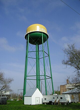
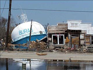
Buras is a census-designated place (CDP) in Plaquemines Parish, Louisiana, United States. Its population was 945 at the 2010 census, and 1,109 in 2020. Prior to the 2010 census, Buras was considered to be part of the Buras-Triumph CDP.

<span class="mw-page-title-main">Pointe à la Hache, Louisiana</span> Place in Louisiana, United States

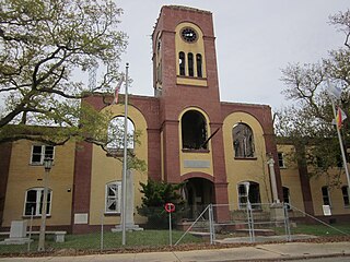
Pointe à la Hache is a census-designated place (CDP) and unincorporated community in Plaquemines Parish, Louisiana, United States. Located on the east bank of the Mississippi River, the village has been the seat for Plaquemines Parish since the formation of the parish. As of the 2020 census, its population was 183, less than half its 1930 population. It suffered severe damage from Hurricane Katrina in 2005 and Tropical Storm Lee in 2011.

<span class="mw-page-title-main">Triumph, Louisiana</span> Census-designated place & Unincorporated community in Louisiana, United States

Triumph is an unincorporated community and census-designated place in Plaquemines Parish, Louisiana, United States. It is located on the south bank of the Mississippi River. As of the 2020 census, its population was 268.

Bayou Goula is an unincorporated community and census-designated place (CDP) in Iberville Parish, Louisiana, United States. Its population was 514 in 2020.

Crescent is an unincorporated community and census-designated place in Iberville Parish, Louisiana, United States. It was first listed as a CDP in the 2010 Census with a population of 959. In 2020, its population was 811.

<span class="mw-page-title-main">Dorseyville, Louisiana</span> Census-designated place in Louisiana, United States

Dorseyville is a census-designated place (CDP) in Iberville Parish, Louisiana, United States, corresponding to the unincorporated community of Dorcyville or Dorseyville. Dorseyville was first listed as a CDP prior to the 2020 census with a population of 159.

References

  1. "2020 U.S. Gazetteer Files". United States Census Bureau. Retrieved March 20, 2022.
  2. "U.S. Census website". United States Census Bureau . Retrieved May 14, 2011.
  3. "2020 Race and Population Totals". United States Census Bureau. Retrieved October 23, 2021.
  4. "US Gazetteer files: 2010, 2000, and 1990". United States Census Bureau. February 12, 2011. Retrieved April 23, 2011.
  5. "US Board on Geographic Names". United States Geological Survey. October 25, 2007. Retrieved January 31, 2008.
  6. "2020 CENSUS - SCHOOL DISTRICT REFERENCE MAP: Plaquemines Parish, LA" (PDF). U.S. Census Bureau . Retrieved January 14, 2024. - Text list
  7. "2020 CENSUS - CENSUS BLOCK MAP (INDEX): Empire CDP, LA" (PDF). U.S. Census Bureau. p. 2 (PDF p. 3/3). Retrieved January 14, 2024. - Compare to the school's entire postal address.
    "Contact". South Plaquemines High School. Retrieved January 14, 2024. Address 34121 Hwy 23 Buras, LA 70041 - While the address states "Buras, LA", the school is physically in the Empire CDP.
  8. "Our Colleges". Louisiana's Technical and Community Colleges . Retrieved June 3, 2021.
  9. "Census of Population and Housing". Census.gov. Retrieved June 4, 2016.
  10. "P004 Hispanic or Latino, and Not Hispanic or Latino by Race – 2000: DEC Summary File 1 – Empire CDP, Louisiana". United States Census Bureau .
  11. "P2 Hispanic or Latino, and Not Hispanic or Latino by Race – 2010: DEC Redistricting Data (PL 94-171) – Empire CDP, Louisiana". United States Census Bureau .
  12. "P2 Hispanic or Latino, and Not Hispanic or Latino by Race – 2020: DEC Redistricting Data (PL 94-171) – Empire CDP, Louisiana". United States Census Bureau .