The Atlantic Ocean is the second-largest of the world's five oceans, with an area of about 85,133,000 km2 (32,870,000 sq mi). It covers approximately 17% of Earth's surface and about 24% of its water surface area. During the Age of Discovery, it was known for separating the New World of the Americas from the Old World of Afro-Eurasia.

North Atlantic Deep Water (NADW) is a deep water mass formed in the North Atlantic Ocean. Thermohaline circulation of the world's oceans involves the flow of warm surface waters from the southern hemisphere into the North Atlantic. Water flowing northward becomes modified through evaporation and mixing with other water masses, leading to increased salinity. When this water reaches the North Atlantic, it cools and sinks through convection, due to its decreased temperature and increased salinity resulting in increased density. NADW is the outflow of this thick deep layer, which can be detected by its high salinity, high oxygen content, nutrient minima, high 14C/12C, and chlorofluorocarbons (CFCs).

The Strait of Gibraltar is a narrow strait that connects the Atlantic Ocean to the Mediterranean Sea and separates Europe from Africa. The two continents are separated by 13 kilometres of ocean at the Strait's narrowest point between Punta de Tarifa in Spain and Point Cires in Morocco. Ferries cross between the two continents every day in as little as 35 minutes. The Strait's depth ranges between 300 and 900 metres.

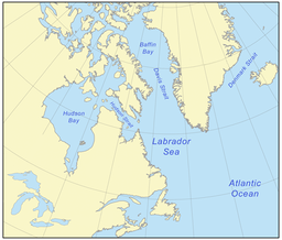
Hudson Strait in Nunavut links the Atlantic Ocean and the Labrador Sea to Hudson Bay in Canada. This strait lies between Baffin Island and Nunavik, with its eastern entrance marked by Cape Chidley in Newfoundland and Labrador and Nunavut and Resolution Island, off Baffin Island. The strait is about 750 km (470 mi) long with an average width of 125 km (78 mi), varying from 70 km (43 mi) at the eastern entrance to 240 km (150 mi) at Deception Bay.

The Gulf of St. Lawrence fringes the shores of the provinces of Quebec, New Brunswick, Nova Scotia, Prince Edward Island, Newfoundland and Labrador, in Canada, plus the islands Saint-Pierre and Miquelon, possessions of France, in North America.

The Drake Passage is the body of water between South America's Cape Horn, Chile, Argentina, and the South Shetland Islands of Antarctica. It connects the southwestern part of the Atlantic Ocean with the southeastern part of the Pacific Ocean and extends into the Southern Ocean. The passage is named after the 16th-century English explorer and privateer Sir Francis Drake.

An ocean current is a continuous, directed movement of seawater generated by a number of forces acting upon the water, including wind, the Coriolis effect, breaking waves, cabbeling, and temperature and salinity differences. Depth contours, shoreline configurations, and interactions with other currents influence a current's direction and strength. Ocean currents are primarily horizontal water movements.

Baffin Bay, located between Baffin Island and the west coast of Greenland, is defined by the International Hydrographic Organization as a marginal sea of the Arctic Ocean. It is sometimes considered a sea of the North Atlantic Ocean. It is connected to the Atlantic via Davis Strait and the Labrador Sea. The narrower Nares Strait connects Baffin Bay with the Arctic Ocean. The bay is not navigable most of the year because of the ice cover and high density of floating ice and icebergs in the open areas. However, a polynya of about 80,000 km2 (31,000 sq mi), known as the North Water, opens in summer on the north near Smith Sound. Most of the aquatic life of the bay is concentrated near that region.

The Davis Strait is a southern arm of the Arctic Ocean that lies north of the Labrador Sea. It lies between mid-western Greenland and Baffin Island in Nunavut, Canada. To the north is Baffin Bay. The strait was named for the English explorer John Davis (1550–1605), who explored the area while seeking a Northwest Passage. By the 1650s it was used for whale hunting.

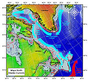
The East Greenland Current (EGC) is a cold, low-salinity current that extends from Fram Strait (~80N) to Cape Farewell (~60N). The current is located off the eastern coast of Greenland along the Greenland continental margin. The current cuts through the Nordic Seas and through the Denmark Strait. The current is of major importance because it directly connects the Arctic to the Northern Atlantic, it is a major contributor to sea ice export out of the Arctic, and it is a major freshwater sink for the Arctic.
The Labrador Current is a cold current in the North Atlantic Ocean which flows from the Arctic Ocean south along the coast of Labrador and passes around Newfoundland, continuing south along the east coast of Canada near Nova Scotia. Near Nova Scotia, this cold water current meets the warm northward moving Gulf Stream. The combination of these two currents produces heavy fogs and has also created one of the richest fishing grounds in the world.

The Greenland Sea is a body of water that borders Greenland to the west, the Svalbard archipelago to the east, Fram Strait and the Arctic Ocean to the north, and the Norwegian Sea and Iceland to the south. The Greenland Sea is often defined as part of the Arctic Ocean, sometimes as part of the Atlantic Ocean. However, definitions of the Arctic Ocean and its seas tend to be imprecise or arbitrary. In general usage the term "Arctic Ocean" would exclude the Greenland Sea. In oceanographic studies the Greenland Sea is considered part of the Nordic Seas, along with the Norwegian Sea. The Nordic Seas are the main connection between the Arctic and Atlantic oceans and, as such, could be of great significance in a possible shutdown of thermohaline circulation. In oceanography the Arctic Ocean and Nordic Seas are often referred to collectively as the "Arctic Mediterranean Sea", a marginal sea of the Atlantic.

The Northwest Atlantic Marine Ecozone, as defined by the Commission for Environmental Cooperation (CEC), is a Canadian marine ecozone forming a transitional region between the cold northern waters of the Arctic Ocean and the more temperate waters in its southern extent.

The Arctic Ocean is the smallest and shallowest of the world's five major oceans. It spans an area of approximately 14,060,000 km2 (5,430,000 sq mi) and is known as one of the coldest of oceans. The International Hydrographic Organization (IHO) recognizes it as an ocean, although some oceanographers call it the Arctic Mediterranean Sea. It has also been described as an estuary of the Atlantic Ocean. It is also seen as the northernmost part of the all-encompassing World Ocean.

The Fram Strait is the passage between Greenland and Svalbard, located roughly between 77°N and 81°N latitudes and centered on the prime meridian. The Greenland and Norwegian Seas lie south of Fram Strait, while the Nansen Basin of the Arctic Ocean lies to the north. Fram Strait is noted for being the only deep connection between the Arctic Ocean and the World Oceans. The dominant oceanographic features of the region are the West Spitsbergen Current on the east side of the strait and the East Greenland Current on the west.

Cod fisheries are fisheries for cod. Cod is the common name for fish of the genus Gadus, belonging to the family Gadidae, and this article is confined to three species that belong to this genus: the Atlantic cod, the Pacific cod and the Greenland cod. Although there is a fourth species of the cod genus Gadus, Alaska pollock, it is commonly not called cod and therefore currently not covered here.

The West Spitsbergen Current (WSC) is a warm, salty current that runs poleward just west of Spitsbergen,, in the Arctic Ocean. The WSC branches off the Norwegian Atlantic Current in the Norwegian Sea. The WSC is of importance because it drives warm and salty Atlantic Water into the interior Arctic. The warm and salty WSC flows north through the eastern side of Fram Strait, while the East Greenland Current (EGC) flows south through the western side of Fram Strait. The EGC is characterized by being very cold and low in salinity, but above all else it is a major exporter of Arctic sea ice. Thus, the EGC combined with the warm WSC makes the Fram Strait the northernmost ocean area having ice-free conditions throughout the year in all of the global ocean.

The borders of the oceans are the limits of Earth's oceanic waters. The definition and number of oceans can vary depending on the adopted criteria. The principal divisions of the five oceans are the Pacific Ocean, Atlantic Ocean, Indian Ocean, Southern (Antarctic) Ocean, and Arctic Ocean. Smaller regions of the oceans are called seas, gulfs, bays, straits, and other terms. Geologically, an ocean is an area of oceanic crust covered by water.
Labrador Sea Water is an intermediate water mass characterized by cold water, relatively low salinity compared to other intermediate water masses, and high concentrations of both oxygen and anthropogenic tracers. It is formed by convective processes in the Labrador Sea located between Greenland and the northeast coast of the Labrador Peninsula. Deep convection in the Labrador Sea allows colder water to sink forming this water mass, which is a contributor to the upper layer of North Atlantic Deep Water. North Atlantic Deep Water flowing southward is integral to the Atlantic Meridional Overturning Circulation. The Labrador Sea experiences a net heat loss to the atmosphere annually.

The Canadian Arctic Rift System is a major North American geological structure extending from the Labrador Sea in the southeast through Davis Strait, Baffin Bay and the Arctic Archipelago in the northwest. It consists of a series of interconnected rifts that formed during the Paleozoic, Mesozoic and Cenozoic eras. Extensional stresses along the entire length of the rift system have resulted in a variety of tectonic features, including grabens, half-grabens, basins and faults.