Lake Bardwell

Last updated
Lake Bardwell
Trinity River Basin
USACE Bardwell Dam and Lake.jpg
USACE Lake Bardwell and Dam
Relief map of Texas.png
Red pog.svg
Lake Bardwell
Lake Bardwell Depth Contour Map.PNG
Location Ellis County, Texas, United States of America
Coordinates 32°16′41″N96°39′29″W / 32.278°N 96.658°W / 32.278; -96.658
Type reservoir
Primary inflows Waxahachie Creek
Primary outflows Waxahachie Creek
Basin  countriesUnited States
Managing agency US Army Corps of Engineers
BuiltSeptember, 1963
First flooded01/01/1965
Max. length5.4 miles (8.7 km)
Max. width1.2 miles (1.9 km)
Surface area3,570 acres (1,440 ha)
Water volume140,000  acre⋅ft (0.17 km3)
Shore length125 miles (40 km)
Surface elevation421 feet (128 m)
Settlements Ennis and Bardwell
References https://tshaonline.org/handbook/online/articles/rob02
1 Shore length is not a well-defined measure.

Lake Bardwell is a lake in Ellis County, Texas. The lake was constructed by the United States Army Corps of Engineers in 1965. Lake Bardwell is not used for military operations, and is accessible to the public for recreational purposes; it has seven facilities, but the state public ramp is closed. [1]

Contents

Description

Lake Bardwell, located completely within Ellis County, is about 45 miles south of Dallas, 10 miles southeast of Waxahachie, and 5 miles south of Ennis. It is located in southeastern Ellis County, with the city of Bardwell due west of the lake. Lake Bardwell is roughly 5.4 miles long and 1.2 miles wide at its widest point, and has a shoreline of 25 miles. Highway 34 passes over the lake, and it is mostly surrounded by forest and farms that use the lake's water. Lake Bardwell is part of the flood control and allied purposes construction project for the Trinity River Basin and Trinity Project Office. [2] [3] Lake construction was completed by the United States Army Corps of Engineers in November 1965 and was created for municipal water supply, flood control, and recreation. [4]

Lake Bardwell was built in a moderately humid climate zone that receives about 32-36 inches of rainfall [5] and the lake has an average temperature of 64.8 °F (18.2 °C), with the warmest month on average being July, and the coolest being January. [6]

The contact number for park staff is: (972) 875-5711. [7]

There are pieces of an old flooded bridge sticking out of the water at the north of the lake. This used to be a bridge across the lake connecting Old Waxahachie Road to Ennis Parkway.

History

Authorization to start the construction of Lake Bardwell was given under the Flood Control Act of March 31, 1960, with construction of the lake beginning in September, 1963. Impoundment of the lake began in November 1965. The total construction cost was $12,630,000. [4] [8]

Lake Bardwell was built to provide flood control and water conservation for surrounding towns, and it receives runoff from 178 square miles of drainage. It has a capacity of about 326,000 gallons, and a flood-control pool that allows the lake to prevent flood damage to surrounding towns and wildlife areas by only letting out as much water as creeks downstream can support. [4]

Although not a primary reason for the production of the lake, the U.S. Army Corps of Engineers allows recreation in the lake, due to recreation being a major component of the U.S. Army Corps of Engineers multiple-use approach to managing the nation's resources. [4]

Military involvement

The U.S. Army Corps of Engineers has not used Lake Bardwell for any military operations, and has allowed the lake to be used for recreational purposes. [3] Lake Bardwell is also used to manage the wetland area around it. Buffalo Creek Wetland (found on the south side of the lake) resulted from a combined effort from the Department of Energy and the U.S. Army Corps of Engineers to offset the destruction of wetlands during the construction of the Superconducting Super Collider. [9]

The construction of Lake Bardwell has protected surrounding cities and grasslands from potential floods. The Secretary of the Army approved a contract on Jun 24th, 1963, allowing the Trinity River Authority to use 25% of the lake's conservation storage space as water supply for the city of Ennis. This agreement was later supplemented in October 1969, allowing 60% of the water conservation pool to be allocated to Ennis, and 40% to Waxahachie. [3] [10] This agreement has allowed both Ennis and Waxahachie's economies to be primarily based on agriculture and agribusiness. [5]

Coronavirus

On April 16, 2020, all recreation areas, including multiuse trails, of Lake Bardwell were closed due to COVID-19. [7]

Activities and facilities

Recreation area facilities

Lake Bardwell opens to the public at 6:00 am and closes at 10:00 pm, visitors leaving after 10:00 are not allowed to re-enter with a vehicle, but may park outside and walk back to their site. [11]

The status of the facilities at Lake Bardwell is:

Facility status [1] [7] [12] [13]
FacilityStatusClosure typeType of facilityRestroomsADA-accessibleParkingCourtesy docksBoat gasPicnic areasCamping
Love ParkPartially closedConstructionParkXXXX
State Public RampFully closedN/AN/A
Little Mustang CreekPartially closedOtherParkXXXX
Waxahachie Creek Park N/ASeasonalParkXXXXX
High View ParkPartially closedOtherParkXXXX (High View Marina)XX
Mott ParkN/ASeasonalParkXXXXX
Overlook ParkFully openN/APark
Buffalo Creek wetlandsFully openN/AAccess point
Lake Bardwell location Lake Bardwell Location.gif
Lake Bardwell location
A U.S. Army Corps of Engineers created map of Love Park Love Park.PNG
A U.S. Army Corps of Engineers created map of Love Park
A U.S. Army Corps of Engineers-created map of Waxahachie Creek Park Waxahachie Creek Park.PNG
A U.S. Army Corps of Engineers-created map of Waxahachie Creek Park

All parks have an area usage fee of $5.00 per vehicle to cover expenses for the facilities and amenities. The marina located in High View Park has a separate charge for use of its facilities. Visitors to campers have no charge imposed on them. [7] The below list is labelled in reference to the image of the lake to the right.

Love park: (A)

State Public Ramp: (B)

A U.S. Army Corps of Engineers created map of High View Park High View Park.PNG
A U.S. Army Corps of Engineers created map of High View Park
A U.S. Army Corps of Engineers created map of Mott Park Mott Park.PNG
A U.S. Army Corps of Engineers created map of Mott Park

Little Mustang Creek Park: (C)

Waxahachie Creek Park: (D)

High View Park & Marina: (E and F)

Mott Park: (G)

Meadow View Nature Area:

Camping

The venue for hire when going group camping in Mott Park at Lake Bardwell MottPark Camping.jpg
The venue for hire when going group camping in Mott Park at Lake Bardwell

Lake Bardwell offers 2 forms of camping; group camping, and developed camping. [14]

A permit is required for events or activities that occur at the park. This includes but is not limited to bounce houses, water slides, weddings, tournaments, bands, DJs, church function, etc. Swimming pools are not allowed no matter the size. [14]

Group camping

At Lake Bardwell, Mott Park and Waxahachie Creek Park offer group camping services. [14]

The shelters are available for reservations, with reservations beginning at 10:00 am and ending at 9:00 am the next day.

Mott Park:

  • 6 picnic tables
  • A barbecue grill
  • 4 hookups for recreational vehicles or camping trailers
  • 27 parking spaces available
  • The shelter accommodates 100 visitors for a daily rate of $80.
The venue for hire when going group camping in Waxahachie Creek Park at Lake Bardwell Waxahachie Creek Park Camping.jpg
The venue for hire when going group camping in Waxahachie Creek Park at Lake Bardwell

Waxahachie Creek Park:

  • Covered shelter
  • 12 picnic tables
  • A barbecue grill
  • 8 hookups for recreational vehicles or camping trailers
  • 66 parking spaces available
  • The shelter accommodates 200 visitors for a daily rate of $120.

Developed camping

Lake Bardwell has three parks that offer developed camping: High View Park, Mott Park, and Waxahachie Creek Park.

Fishing

The fishing regulations for Lake Bardwell are managed under statewide regulations. Hybrids are stocked annually. [15]

Crappie are usually caught at either the Highview Marina, under the Highway 34 bridge, or in Waxahachie and Mustang Creeks during spawning. [13]

The different types of fish found in Lake Bardwell and the quantity of fish are:

Quantity of fish in the lake [16]
SpeciesPoorFairGoodExcellentPreferred bait
Largemouth bass X
Catfish XLive
Crappie XLive
White bass XNoisemaking lures
Hybrid striped bass XNoisemaking lures
SunfishX

The largest bass caught at a Texas lake was caught using a McDonald's chicken McNugget. The Highview Marina declared it the biggest fish caught at Lake Bardwell, stating it weighed 10.802 lb, and was 24 and 1/2 inches long. The couple who caught the bass tossed it back into the lake after reviewing it. [17]

Fears arose of an invasive species of mussel spreading into Ellis County by infected boats going fishing in the lake, but no confirmation has been found that the zebra mussel has made its way into Lake Bardwell. [18] [19]

Deaths

On December 17, 2018, authorities pronounced two men deceased at 2:50 pm. They were identified as Richard Ly, 61, and Van Cao, 47, both from Arlington. The Dallas County medical examiner's office stated that the cause of death was an accidental drowning while on a fishing trip. A local grocery store worker noticed that the two regulars anglers did not come by the store that Monday night, and called law enforcement. [20] Game warden Jeff Powell and the sheriff's deputy went to the lake on the morning of December 16, and were called by a resident who said he spotted something in the water. After confirming that the two individuals were in the water, drone footage showed that the bodies were 200 yards apart and that neither of the individuals were wearing a life jacket. Powell stated he found no indication of foul play, and that it "looks like a tragic accident". [21]

Birdwatching

Birdwatching is a pastime for many of the visitors at Lake Bardwell. [22] [23]

Trails

The Bardwell Equestrian and Multiuse Trail Trails of Lake Bardwell.PNG
The Bardwell Equestrian and Multiuse Trail
A U.S. Army Corps of Engineers created map of Tonkawa Trail Tonakawa Trail.PNG
A U.S. Army Corps of Engineers created map of Tonkawa Trail

The Bardwell Equestrian and Multiuse trail is over 13 miles; visitors can hike, bike, or ride horses on it. The trail provides a round trip of about 26 miles. Trail etiquette gives equestrians the right of way. [24] The lake offers a flat main trail, with numerous loops into surrounding meadows, croplands, and bottomland hardwood forest along Waxahachie Creek. The trail is within the designated hunting area surrounding the lake. [25] [26]

The trail head offers: [25]

The Tonkawa Trail (Buffalo Creek Wetland Trail) is almost a mile long, and provides access to the various components of Buffalo Creek Wetland. The ground is firm due to a 4- to 6-inch layer of crushed granite. Four observation shelters along the trail provide an opportunity to observe some of the plants or animals that live in the Buffalo Creek Wetlands. [25]

The Waxahachie Trail is a dense upper canopy of bottomland hardwood trees, which covers most of the journey. Visitors hiking this trail can see the three layers of forest vegetation. [25]

Other activities

Boating

Boat Ramp Information [27]
Boat ramp nameRamp locationAgencyFeeSeason
Love ParkBeach Rd.USACE$4.00Apr 1-Sep 30
High View Park262 High View Rd.USACE$4.00All year
Little Mustang CreekLane View RdUSACEFreeAll year
Mott Park957 FM 985USACE$4.00Apr 1-Sep 30
Waxahachie Creek Park930 BozekUSACE$4.00Apr 1-Sep 30
Hunting map of Lake Bardwell Hunting map of Lake Bardwell.PNG
Hunting map of Lake Bardwell

Hunting

A permit is not needed to go hunting at Lake Bardwell. Lake Bardwell's hunting ground covers 2,528 acres.

The hunting program for Lake Bardwell is managed by the Fort Worth District of the U.S. Army Corps of Engineers, who work with Texas Parks and Wildlife Department and several other entities to provide hunting opportunities. [28]

Swimming

Lake Bardwell has two developed swim beaches. Neither of these beaches has lifeguards provided. Pets, grills, and glass containers are prohibited in the designated swim beach area. [29]

High View Park:

  • The beach is around 300 ft long and 100 ft wide.
  • A vault-type restroom and asphalt parking areas are close to the swimming area.
  • A $4.00 per vehicle area use fee or valid annual pass is required to use the beach.

Mott Park:

  • The beach is about 300 ft long and 100 ft wide.
  • A waterborne-type restroom with showers and asphalt parking areas are close to the swimming area.
  • A $4.00 per vehicle area use fee or valid annual pass is required to use the beach.

Wildlife

Flora

Meadow View Nature Area with bluebonnets in the foreground Bardwell Blue bonnets.jpg
Meadow View Nature Area with bluebonnets in the foreground

Bluebonnets can be found in the Meadow View Nature Area.

Hydrilla can be found north of the Highway 34 Bridge.

Fauna

Many species of birds visit the lake, such as ducks, herons, egrets, songbirds, hawks, and cormorants. [22] [23] Lake Bardwell is a link in the chain of lakes that whooping cranes use for their migration. The whooping cranes stop 15 to 20 times on their 2,500-mile migration every year to rest and feed, but due to most of Lake Bardwells' shore area being developed for recreational use, the cranes have trouble roosting, as they normally roost in water with a depth of 2 to 10 inches. [30]

In the Buffalo Creek Wetland, ponds contain frogs and crayfish, which often are stalked by great blue herons and great egrets. In the woods section of the Buffalo Creek Wetland trail, visitors may find many woodland species such as downy and red-bellied woodpeckers and barred owls. [31]
Lake Bardwells' fish are stocked to ensure anglers have enough opportunities, while also ensuring that the lake's ecosystem survives. Sunfish (green x red-ear), catfish (channel, blue), and bass (sunshine, striped, palmetto, largemouth, Florida largemouth) are stocked. [15]

Related Research Articles

<span class="mw-page-title-main">Beaver Lake (Arkansas)</span> Man-made reservoir in Arkansas, United States

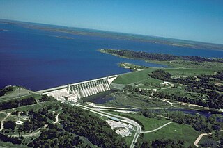
Beaver Lake is a man-made reservoir in the Ozark Mountains of Northwest Arkansas and is formed by a dam across the White River. Beaver Lake has some 487 miles (784 km) of shoreline. With towering limestone bluffs, natural caves, and a wide variety of trees and flowering shrubs, it is a popular tourist destination. Beaver Lake is the source of drinking water in Northwest Arkansas, which is managed, treated and sold by Beaver Water District, serving more than 450,000 customers. One out of 7 people in Arkansas get their drinking water from Beaver Lake.

<span class="mw-page-title-main">Conecuh National Forest</span> National Forest in Alabama, US

The Conecuh National Forest in southern Alabama covers 83,000 acres (340 km2), along the Alabama - Florida line in Covington and Escambia counties. Topography is level to moderately sloping, broad ridges with stream terraces and broad floodplains.

<span class="mw-page-title-main">Caesar Creek State Park</span> State park in Ohio, United States

Caesar Creek State Park is a public recreation area located in southwestern Ohio, five miles (8 km) east of Waynesville, in Warren, Clinton, and Greene counties. The park is leased by the State from the U.S. Army Corps of Engineers, who in the 1970s erected a dam on Caesar Creek to impound a 2,830-acre (1,150 ha) lake. The total park area, including the lake, is 7,530-acre (3,050 ha).

<span class="mw-page-title-main">Lake Whitney (Texas)</span> Reservoir in Texas, United States

Lake Whitney is a flood control reservoir on the main stem of the Brazos River in Texas. It is located on River Mile Marker 442 and controls drainage for 17,656 square miles (45,730 km2) of Texas and parts of New Mexico. The reservoir encompasses a surface area of more than 23,500 acres and 225 miles (362 km) of shoreline. The area consists of rolling, tallgrass prairies; cedar trees; hardwood timber; and 100 ft (30 m) bluffs and rock points. Lake Whitney is also part of the Texas Lakes Trail Region of North Texas.

<span class="mw-page-title-main">Jim Chapman Lake</span> Reservoir in Texas, United States

Jim Chapman Lake is a 19,305-acre (78.12 km2) impoundment operated by the Army Corps of Engineers and is located 75 miles (121 km) east of the Dallas/Fort Worth Metroplex in the state of Texas.

<span class="mw-page-title-main">Sam Houston National Forest</span> National forest in east Texas

The Sam Houston National Forest, one of four National Forests in Texas, is located 50 miles north of Houston. The forest is administered together with the other three United States National Forests and two National Grasslands located entirely in Texas, from common offices in Lufkin, Texas. The units include Angelina, Davy Crockett, Sabine, and Sam Houston National Forests, plus Caddo National Grassland and Lyndon B. Johnson National Grassland. There are local ranger district offices located in New Waverly. It is located in portions of three Texas counties including Montgomery, San Jacinto, and Walker.

<span class="mw-page-title-main">Big Hill Lake</span> Reservoir in Labette County, Kansas

Big Hill Lake is a body of water in Labette County, Kansas, United States. It is located 3.5 miles (5.6 km) east of Cherryvale and 9.5 miles (15.3 km) southwest of Parsons. The reservoir holds 1,240 acres (5.0 km2) of water, with 367 acres (1.49 km2) available for public use. Fishing, picnicking, boating, and a sandy beach swimming area are popular activities. The lake is operated by the U.S. Army Corps of Engineers.

<span class="mw-page-title-main">Cleburne State Park</span> State park in Texas, United States

Cleburne State Park is a 528-acre (2.14 km2) Texas state park in Johnson County, Texas operated by the Texas Parks and Wildlife Department. The park includes the 116-acre (0.47 km2), spring-fed Cedar Lake that was created by construction of an earthen dam by the Civilian Conservation Corps.

<span class="mw-page-title-main">Tyler State Park (Texas)</span> State park in Texas, United States

Tyler State Park is a state park north of Tyler, Texas. It is 985.5 acres (399 ha) in Smith County, north of Tyler. The park includes a 64-acre (26 ha) lake. The land was deeded by private owners in 1934 and 1935; original improvements were made by the Civilian Conservation Corps (CCC). The park opened in 1939.

<span class="mw-page-title-main">Lost Creek Lake</span> Reservoir in Jackson County, Oregon

Lost Creek Lake is a reservoir located on the Rogue River in Jackson County, Oregon, United States. The lake is impounded by William L. Jess Dam which was constructed by the U.S. Army Corps of Engineers in 1977 for flood control and fisheries enhancement. The lake and dam were the first completed elements of the multi-purpose Rogue River Basin Project, consisting of Lost Creek Lake, Applegate Lake and the Elk Creek project. The lake is located approximately 27 miles (43 km) northeast of Medford.

<span class="mw-page-title-main">Westville Dam</span> Dam in Southbridge and Sturbridge, Massachusetts

The Westville Dam is located on the Quinebaug River between Southbridge and Sturbridge, about 1.3 miles (2.1 km) west of the Southbridge town center and 18 miles (29 km) southwest of Worcester, Massachusetts.

<span class="mw-page-title-main">Colt Creek State Park</span> State park in Florida, United States

Colt Creek State Park is a Florida State Park in Central Florida, 16 miles (26 km) north of Lakeland off of State Road 471. This 5,067 acre park nestled within the Green Swamp Wilderness Area and named after one of the tributaries that flows through the property was opened to the public on January 20, 2007. Composed mainly of pine flatwoods, cypress domes and open pasture land, this piece of pristine wilderness is home to many animal species including the American bald eagle, Southern fox squirrel, gopher tortoise, white-tailed deer, wild turkey and bobcat.

Brushy Creek State Recreation Area is a state park in Webster County, Iowa in the United States. With an area encompassing over 6,000 acres (24 km2), the facility is one of Iowa's largest public outdoor recreation areas.

Eisenhower State Park is a state park located in Grayson County, Texas, northwest of Denison, Texas on the shores of Lake Texoma. The park is 423.1 acres (171 ha).

<span class="mw-page-title-main">Marion Reservoir</span> Reservoir in Marion County, Kansas

Marion Reservoir is a body of water on the Cottonwood River, 3 miles (4.8 km) north-west of Marion on the western edge of the Flint Hills region of Kansas in the United States. The reservoir was completed in 1968 for flood control and is operated by the Army Corps of Engineers.

<span class="mw-page-title-main">Lake Whitney State Park</span> State park in Texas, United States

Lake Whitney State Park is a state park located in Hill County, Texas, near Whitney, Texas. The park is 775 acres (314 ha).

Navarro Mills Lake is located in Navarro County, Texas. It is located 20 miles west of Corsicana, and about 35 miles east of Waco.

Lake Charlotte is an estuarine lake located three miles outside of Wallisville, Texas a town northeast of the Houston metroplex. The lake connects to the Trinity Rivers system by way of the Mac Bayou. The lake is 1 1/2 miles long by 1 1/2 miles wide and encircled by a cypress swamp. Lake Charlotte is an integral part of the marshland ecosystem in the area, providing a habitat to many marine and freshwater species.

<span class="mw-page-title-main">Lake Somerville State Park and Trailway</span> State park in Texas, United States

Lake Somerville State Park and Trailway is an 8700-acre state park located in Lee County and Burleson County, Texas on the shore of Lake Somerville. The park is a complex of four units; Lake Somerville State Park-Birch Creek Unit, Lake Somerville State Park-Nails Creek Unit, Somerville Trailway and Somerville Public Hunting Land. The park opened in 1970 and is managed by the Texas Parks and Wildlife Department (TPWD)

Waxahachie Creek is a creek in Ellis County, Texas. The creek rises in Midlothian and flows for 23 miles, running parallel with U.S. Highway 287 from Midlothian to Waxahachie. The creek skirts Lake Waxahachie Lake, flowing under U.S. Highway 77 before flowing into Lake Bardwell near Ennis.

References

  1. 1 2 "Lake Bardwell Access". tpwd.texas.gov. Retrieved 2020-03-31.
  2. "Bardwell Lake (Trinity River Basin) | Texas Water Development Board". www.twdb.texas.gov. Retrieved 2020-03-31.
  3. 1 2 3 "Lake Information". www.swf-wc.usace.army.mil. Retrieved 2020-04-16.
  4. 1 2 3 4 "History". www.swf-wc.usace.army.mil. Retrieved 2020-03-31.
  5. 1 2 Bardwell, Benbrook (1977). Grapevine and Navarro Mills Lakes O&M, Trinity River Basin: Environmental Impact Statement. pp. 17–20.
  6. "Bardwell Lake, Texas Köppen Climate Classification (Weatherbase)". Weatherbase. Retrieved 2020-05-25.
  7. 1 2 3 4 "Bardwell Lake". www.swf-wc.usace.army.mil. Retrieved 2020-04-05.
  8. "Water Data For Texas". www.waterdatafortexas.org. Retrieved 2020-04-16.
  9. "Natural Resources". www.swf-wc.usace.army.mil. Retrieved 2020-04-16.
  10. Dowell, C. (1964-07-01). "Texas Water Commission" (PDF). tshaonline.org. Retrieved 2020-04-16.
  11. "FAQ". www.swf-wc.usace.army.mil. Retrieved 2020-04-22.
  12. "Corps of Engineers Parks". www.swf-wc.usace.army.mil. Retrieved 2020-04-16.
  13. 1 2 Behrens, Tom (2009-09-15). Camping Texas: A Comprehensive Guide to More Than 200 Campgrounds. Rowman & Littlefield. pp. 32–33. ISBN   978-0-7627-5801-2.
  14. 1 2 3 "Group Camping at Lake Bardwell". swf-wc.usace.army.mil.
  15. 1 2 "Stocking Report for Bardwell". tpwd.texas.gov. Retrieved 2020-05-25.
  16. "Fishing Lake Bardwell". tpwd.texas.gov. Retrieved 2020-04-05.
  17. "Couple catch largest bass in Texas lake using unusual bait". News.Com.Au. 2017-06-03. Retrieved 2020-04-22.
  18. Douty, Samantha (2019-06-10). "Invasive species growing in North Texas lakes, none yet found in Ellis County". Waxahachie Daily Light. Retrieved 2020-03-31.
  19. "Texas Invasives". www.texasinvasives.org. Retrieved 2020-04-16.
  20. "Two Bodies Pulled From North Texas Lake Bardwell". NBC 5 Dallas-Fort Worth. Dec 19, 2018. Retrieved 2020-04-22.
  21. Branca, Andrew (Dec 18, 2018). "Two bodies recovered from Lake Bardwell". Waxahachie Sun. Retrieved 2020-04-22.
  22. 1 2 "Natural Resources". www.swf-wc.usace.army.mil. Retrieved 2020-04-16.
  23. 1 2 Miller, George (1999). Texas parks & campgrounds. Lone Star Books. ISBN   0-89123-034-3. OCLC   40805434.
  24. Sanchez, Joanie (2011-11-08). 60 Hikes Within 60 Miles: Dallas/Fort Worth. Menasha Ridge Press. ISBN   978-0-89732-928-6.
  25. 1 2 3 4 "Trails". www.swf-wc.usace.army.mil. Retrieved 2020-05-12.
  26. "Hunting - Outdoor Annual - TPWD". tpwd.texas.gov. Retrieved 2020-05-12.
  27. "Boat Ramps at Lake Bardwell". swf-wc.usace.army.mil.
  28. "Hunting at Lake Bardwell". swf-wc.usace.army.mil.
  29. "Swimming at Lake Bardwell". swf-wc.usace.army.mil.
  30. "Corps of Engineers' Bardwell Lake is another stepping stone in the Whooping Crane migration corridor". Friends of the Wild Whoopers. 2018-02-22. Retrieved 2020-05-12.
  31. "Big Woods Loop — Texas Parks & Wildlife Department". tpwd.texas.gov. Retrieved 2020-05-25.

Further reading

More information on statewide regulation for fishing

Weight records for Fish caught in Lake Bardwell

Full stocking report for Lake Bardwell

Fisheries data for 2018-2019

Best fishing times for Lake Bardwell

Maps of the Parks within Lake Bardwell

Water levels of the Lake

Complete set of rules and regulations for recreation at Lake Bardwell

Full list of bird sightings at the lake:

Bardwell Lake from the Handbook of Texas Online