Mathis is a city in San Patricio County, Texas, United States. The population was 4,942 at the 2010 census.

The Nueces River is a river in the U.S. state of Texas, about 315 miles (507 km) long. It drains a region in central and southern Texas southeastward into the Gulf of Mexico. It is the southernmost major river in Texas northeast of the Rio Grande. Nueces is Spanish for nuts; early settlers named the river after the numerous pecan trees along its banks.

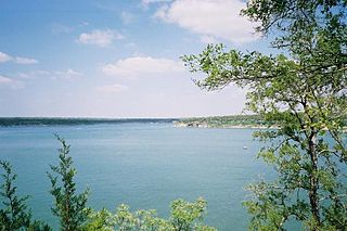
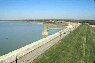
Lake Whitney is a flood control reservoir on the main stem of the Brazos River in Texas. It is located on River Mile Marker 442 and controls drainage for 17,656 square miles (45,730 km2) of Texas and parts of New Mexico. The reservoir encompasses a surface area of more than 23,500 acres and 225 miles (362 km) of shoreline. The area consists of rolling, tallgrass prairies; cedar trees; hardwood timber; and 100 ft (30 m) bluffs and rock points. Lake Whitney is also part of the Texas Lakes Trail Region of North Texas.
Lake Georgetown is a reservoir on the north fork of the San Gabriel River in central Texas in the United States. Lake Georgetown is a U.S. Army Corps of Engineers reservoir formed on the San Gabriel by the North San Gabriel Dam, which is located about three miles west of Georgetown, Texas. The dam, lake, and all adjacent property are managed by the Fort Worth District of the U.S. Army Corps of Engineers. The dam was officially completed on October 5, 1979, and serves to provide flood control for the community of Georgetown. Lake Georgetown is also a source of drinking water for Georgetown and the nearby city of Round Rock. The lake is also a popular recreational destination.

Amistad Reservoir is a reservoir on the Rio Grande at its confluence with the Devils River 12 miles (19 km) northwest of Del Rio, Texas. The lake is bounded by Val Verde County on the United States side of the international border and by the state of Coahuila on the Mexican side of the border; the American shoreline forms the Amistad National Recreation Area. The reservoir was formed in 1969 by the construction of Amistad Dam. The dam and lake are managed jointly by the governments of the United States and Mexico through the International Boundary and Water Commission. The name of the dam and lake is the Spanish word for "friendship". The reservoir is also known as Lake Amistad.
Millwood Lake is a reservoir in southwestern Arkansas, United States. It is located 9 miles (14 km) from Ashdown and is formed from the damming of the point where Little River and Saline River meet.

Choke Canyon Reservoir is a reservoir in South Texas, United States. The lake and the dam that creates it are owned by the United States Bureau of Reclamation and managed by the City of Corpus Christi.

Lake Bastrop is a reservoir on Spicer Creek in the Colorado River basin 3 miles (5 km) northeast of the town of Bastrop in central Bastrop County, Texas, United States. The reservoir was formed in 1964 by the construction of a dam by the Lower Colorado River Authority. The lake serves primarily as a power plant cooling pond for the Sim Gideon Power Plant operated by the LCRA and the Lost Pines Power Project 1, owned by GenTex Power Corporation, a wholly owned affiliate of the LCRA. Lake Bastrop also serves as a venue for outdoor recreation, including fishing, boating, swimming, camping and picnicking, and is maintained at a constant level year round.
Lake Wood was a reservoir on the Guadalupe River 4 miles (6 km) west of the town of Gonzales in Gonzales County, Texas. The reservoir was formed in 1931 by the construction of a dam to provide hydroelectric power to the area. Management of the dam and lake was assumed by the Guadalupe-Blanco River Authority on May 1, 1963. Lake Wood served as a venue for outdoor recreation, including fishing and boating.

Falcon International Reservoir, commonly called Falcon Lake, is a reservoir on the Rio Grande 40 miles (64 km) southeast of Laredo, Texas, United States, and Nuevo Laredo, Tamaulipas, Mexico. The huge lake is bounded by Starr and Zapata Counties on the Texas side of the international border and the municipality and city of Nueva Ciudad Guerrero on the Tamaulipas side. The reservoir was formed by the construction of the Falcon Dam to provide water conservation, irrigation, flood control, and hydroelectricity to the area.

Lake Casa Blanca is a reservoir on the Chacon Creek, 5 miles (8 km) northeast of downtown Laredo, Texas, United States. The reservoir was formed in 1951 by the construction of a dam to provide recreational opportunities for the residents of Webb County. The current dam is the second built across the creek - a previous dam built in 1946 failed the following year during the initial attempted impounding of a reservoir. There are residential properties along the lake as well as a Texas state park. Surrounding the lake is a 525-acre (212 ha) park that was operated jointly by the City of Laredo and Webb County before it was leased by the state in 1990 and opened in March 1991 as the Lake Casa Blanca International State Park. Lake Casa Blanca is fed by the Chacon Creek and San Ygnacio Creek.
Averhoff Reservoir is a 173-acre narrow, riverine-type reservoir located on the Nueces River 10 mi (16 km) north of the town of Crystal City in Zavala County, Texas, United States, and 100 miles from San Antonio, Texas.
Coleto Creek Reservoir is a reservoir on Coleto Creek and Perdido Creek located in Fannin, Texas, 15 miles (24 km) southwest of Victoria, Texas. The surface of the lake extends into Victoria and Goliad counties. The reservoir was formed in 1980 by the construction of a dam by the Guadalupe-Blanco River Authority to provide a power station cooling pond for electric power generation. Coleto Creek Reservoir is a venue for outdoor recreation, including fishing and boating.

Cedar Creek Reservoir is a reservoir located in Henderson and Kaufman Counties, Texas (USA), 50 miles (80 km) southeast of Dallas. It is built on Cedar Creek, which flows into the Trinity River. Floodwaters are discharged through a gated spillway into a discharge channel that connects to the Trinity River.
Grapevine Lake is a reservoir located in the North Texas region, about 20 mi (32 km) northwest of Dallas and northeast of Fort Worth. It was impounded in 1952 by the US Army Corps of Engineers when they dammed Denton Creek, a tributary of Trinity River.

Senecaville Lake is a reservoir in Guernsey and Noble Counties, Ohio. It is located approximately 13 miles (21 km) southeast of Cambridge near the village of Senecaville, Ohio. The lake is popular among recreation and fishing enthusiasts. It is often referred to locally as Seneca Lake.
Richland-Chambers Reservoir is the third largest inland reservoir by surface area and the 8th largest reservoir by water volume in Texas formed by the impoundment of Richland Creek and Chambers Creek east-southeast of the town of Corsicana and south of Kerens, in Navarro County and Freestone County, Texas, USA. It has 330 miles (530 km) of shoreline and is "Y" shaped with the dam on the eastern end of the lake.
Lake Pueblo State Park is a state park located in Pueblo County, Colorado. It includes 60 miles (97 km) of shoreline and 10,000 acres (40 km2) of land. Activities it offers include two full-service marinas, recreational fishing, hiking, camping and swimming at a special swim beach.

O.C. Fisher Reservoir is an artificial lake located west of the city of San Angelo, Texas. With the financial support of the Upper Colorado River Authority, construction on the dam to form the reservoir was begun by the United States Army Corps of Engineers in 1947 and the lake was officially impounded in 1952. Originally named San Angelo Lake, the reservoir was renamed in 1975 for local U.S. Congressman O.C. Fisher, to honor his 23 years of service in the United States Congress.
Twin Buttes Reservoir is an artificial lake located about 6 mi (9.7 km) southwest of the city of San Angelo, Texas, and immediately upstream from Lake Nasworthy. Construction on Twin Buttes Dam to form the reservoir was completed in 1963. The dam is an unusual one – it dams the Middle and South Concho Rivers separately; a stabilization channel runs between the two sides of the lake. Water levels fell significantly during the 2010–13 Southern United States drought and remained low into 2014.


