Leasburg Dam State Park

Last updated
Leasburg Dam State Park
New Mexico State Park
Country United States
State New Mexico
County Doña Ana
Location Las Cruces
 - elevation 4,200 ft (1,280 m)
 - coordinates 32°29′49″N106°55′22″W / 32.49694°N 106.92278°W / 32.49694; -106.92278 Coordinates: 32°29′49″N106°55′22″W / 32.49694°N 106.92278°W / 32.49694; -106.92278
Area 293 acres (119 ha)
Founded 1971 [1]
Management New Mexico State Parks Division
Owner U.S. Bureau of Reclamation [1]
USA New Mexico location map.svg
Red pog.svg
Location of Leasburg Dam State Park in New Mexico

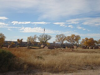
Leasburg Dam State Park is a state park of New Mexico, United States, located on the Rio Grande. It provides opportunities for camping, hiking, picnicking, swimming, and wildlife viewing. Nearby is the historic Fort Seldon State Monument, and 15 miles (24 km) to the south is the city of Las Cruces.

State park protected area managed at the federated state level

State parks are parks or other protected areas managed at the sub-national level within those nations which use "state" as a political subdivision. State parks are typically established by a state to preserve a location on account of its natural beauty, historic interest, or recreational potential. There are state parks under the administration of the government of each U.S. state, some of the Mexican states, and in Brazil. The term is also used in the Australian state of Victoria. The equivalent term used in Canada, Argentina, South Africa and Belgium, is provincial park. Similar systems of local government maintained parks exist in other countries, but the terminology varies.

New Mexico State of the United States of America

New Mexico is a state in the Southwestern region of the United States of America; its capital and cultural center is Santa Fe, which was founded in 1610 as capital of Nuevo México, while its largest city is Albuquerque with its accompanying metropolitan area. It is one of the Mountain States and shares the Four Corners region with Utah, Colorado, and Arizona; its other neighboring states are Oklahoma to the northeast, Texas to the east-southeast, and the Mexican states of Chihuahua to the south and Sonora to the southwest. With a population around two million, New Mexico is the 36th state by population. With a total area of 121,592 sq mi (314,920 km2), it is the fifth-largest and sixth-least densely populated of the 50 states. Due to their geographic locations, northern and eastern New Mexico exhibit a colder, alpine climate, while western and southern New Mexico exhibit a warmer, arid climate.

Rio Grande River forming part of the US-Mexico border

The Rio Grande is one of the principal rivers in the southwest United States and northern Mexico. The Rio Grande begins in south-central Colorado in the United States and flows to the Gulf of Mexico. Along the way, it forms part of the Mexico–United States border. According to the International Boundary and Water Commission, its total length was 1,896 miles (3,051 km) in the late 1980s, though course shifts occasionally result in length changes. Depending on how it is measured, the Rio Grande is either the fourth- or fifth-longest river system in North America.

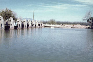
The dam at Leasburg was completed in 1908. Its purpose is not to hold back the flow of the river, but instead to divert it into a system of canals for use by nearby farms. [2]

Leasburg Diversion Dam

The Leasburg Diversion Dam is a structure completed in 1907 on the Rio Grande in New Mexico, United States. It diverts water from the Rio Grande into the 13.7 miles (22.0 km) long Leasburg Canal, which carries irrigation water into the upper Mesilla Valley, north of Las Cruces, New Mexico.

Canal man-made channel for water

Canals, or navigations, are human-made channels, or artificial waterways, for water conveyance, or to service water transport vehicles.

Known for its rich history, early settlers used the area as a passage to Jornada del Muerto, the nearby site of a 19th-century army outpost is a reminder of a time not too long ago. Leasburg Dam State Park offers year-round camping, picnicking, and birdwatching. From about mid-March to mid-October the park is also a venue for fishing, canoeing, and kayaking in the Rio Grande. The dam channels water from the Rio Grande for irrigation in the Mesilla Valley. Nearby a museum and a number of trails are located near Fort Seldon State Monument.

Jornada del Muerto

The name Jornada del Muerto is translated loosely from Spanish, historically referring to it as the "Journey of the Dead Man", though the modern literal translation is closer to "The Working Day of the Dead". As a geographic name, "Jornada del Muerto" is the desert region the Conquistadors had to cross to make it from Las Cruces to Socorro, New Mexico. As a name-place, "Jornada del Muerto" is a loose translations of "single day's journey of the dead man" hence "route of the dead man") in the U.S. state of New Mexico was the name given by the Spanish conquistadors to the Jornada del Muerto Desert basin, and the particularly dry 100-mile (160 km) stretch of a route through it.

Birdwatching hobby

Birdwatching, or birding, is a form of wildlife observation in which the observation of birds is a recreational activity or citizen science. It can be done with the naked eye, through a visual enhancement device like binoculars and telescopes, by listening for bird sounds, or by watching public webcams.

Mesilla Valley valley in Texas, United States of America

The Mesilla Valley is a geographic feature of Southern New Mexico and far West Texas. It was formed by repeated heavy spring floods of the Rio Grande.

Related Research Articles

Scouting in New Mexico

Scouting in New Mexico has had a rich and colorful history, from the 1910s to the present day, serving thousands of youth in programs that suit the environment in which they live. The state is home to the Philmont Scout Ranch.

Questa, New Mexico Village in New Mexico, United States

Questa is a village in Taos County, New Mexico, United States. The population was 1,767 at the 2000 census. The village has trails into the Rio Grande Gorge, trout fishing, and mountain lakes with trails that access the Sangre de Cristo Mountains which overlook the area. Questa is located on the Enchanted Circle Scenic Byway, near the confluence of the Rio Grande and the Red River. As the "Gateway to the Rio Grande del Norte Monument" visitors can drive to an overlook of the Red River meeting the Rio Grande in the depth of the Gorge. The Carson National Forest parallels Questa to the east. The Columbine Hondo Wilderness and Latir Peak Wildness are found in the Carson National Forest close to Questa.

Pecos River river in the United States of America

The Pecos River originates in north-central New Mexico and flows into Texas, emptying into the Rio Grande. Its headwaters are on the eastern slope of the Sangre de Cristo mountain range in Mora County north of Pecos, NM, at an elevation of over 12,000 feet (3,700 m) feet. The river flows for 926 miles (1,490 km) before reaching the Rio Grande near Del Rio. Its drainage basin encompasses about 44,300 square miles (115,000 km2).

Elephant Butte Reservoir

Elephant Butte Reservoir is a reservoir on the Rio Grande in the U.S. state of New Mexico, 5 miles (8.0 km) north of Truth or Consequences. This reservoir is the 84th largest man-made lake in the United States, and the largest in New Mexico by total surface area and peak volume. It is the only place in New Mexico where one can find pelicans perched on or alongside the lake. There are also temporary US Coast Guard bases stationed at Elephant Butte. It is impounded by Elephant Butte Dam and is part of the largest state park in New Mexico, Elephant Butte Lake State Park.

Elephant Butte Dam New Mexico Place listed on National Register of Historic Places

Elephant Butte Dam or Elephant Butte Dike is a concrete gravity dam on the Rio Grande river near Truth or Consequences, New Mexico. The dam impounds Elephant Butte Reservoir, which is used mainly for agriculture, and also provides for recreation, hydroelectricity and flood control. The construction of the dam has reduced the flow of the Rio Grande to a small stream for most of the year, with water released only during the summer irrigation season, or during times of exceptionally heavy snow melt.

Amistad National Recreation Area

Amistad National Recreation Area is a park unit managed by National Park Service (NPS) that includes the area around the Amistad Reservoir at the confluence of the Rio Grande, the Devils River, and the Pecos River near Del Rio in Val Verde County, Texas. The reservoir was created by the Amistad Dam, completed in 1969, located on the Rio Grande at the United States-Mexico border across from the city of Ciudad Acuña in the Mexican state of Coahuila. Amistad, Spanish for "friendship," refers broadly to the close relationship and shared history between Ciudad Acuña and Del Rio.

Amistad Reservoir reservoir on the Rio Grande at its confluence with the Devils River in Texas and Mexico

Amistad Reservoir is a reservoir on the Rio Grande at its confluence with the Devils River 12 miles (19 km) northwest of Del Rio, Texas. The lake is bounded by Val Verde County on the United States side of the international border and by the state of Coahuila on the Mexican side of the border; the American shoreline forms the Amistad National Recreation Area. The reservoir was formed in 1969 by the construction of Amistad Dam. The dam and lake are managed jointly by the governments of the United States and Mexico through the International Boundary and Water Commission. The name of the dam and lake is the Spanish word for "friendship". The reservoir is also known as Lake Amistad.

Fort Selden

Fort Selden was a United States Army post, occupying the area in what is now Radium Springs, New Mexico. The site was long a campground along the El Camino Real de Tierra Adentro. It was the site of a Confederate Army camp in 1861. The U. S. Army established Fort Selden in 1865 for the purpose of protecting westward settlers from Native American raids, the post fell into disrepair after the American Civil War. It was ultimately abandoned in 1891, due in large part to the decision to expand Fort Bliss and the lack of any expenditures for repair of the facility.

Boca Chica State Park

Boca Chica State Park was a Texas state park located in the Boca Chica Subdelta of the Rio Grande near Brownsville in southeastern Cameron County, Texas. The park was acquired and opened in May 1994. In July 2007 Texas Parks & Wildlife transferred the land to the United States Fish & Wildlife Service under a 50-year lease agreement. Boca Chica is now part of the Lower Rio Grande Valley National Wildlife Refuge, as is Brazos (Santiago) Island.

Rio Grande Trail

The Rio Grande Trail is a proposed long distance trail along the Rio Grande in the U.S. state of New Mexico. The river extends over 1,800 total miles, some 700 miles (1,100 km) of which pass through the heart of New Mexico. It is the state's primary drainage feature and most valuable natural and cultural resource. The river and its bosque provide a wide variety of recreation, including hunting and fishing, birdwatching, river rafting, hiking, biking, and horseback riding. The river also flows through or beside numerous spectacular and geologically interesting landforms, the result of extensive volcanism and erosion within the Rio Grande Rift. Although some trail advocates would like to see the trail extended the full distance through New Mexico, from the Colorado border to the United States–Mexico border, the portion proposed for initial development extends 300 miles (480 km), from Bernalillo south to Las Cruces.

Elephant Butte Lake State Park state park in New Mexico, United States

Elephant Butte Lake State Park is a state park of New Mexico, United States, located 7 miles (11 km) north of Truth or Consequences along the shore of Elephant Butte Reservoir. It is the largest state park in New Mexico and surrounds the state's largest reservoir. The 36,000-acre (150 km2) reservoir, created in 1916 across the Rio Grande, is 40 miles (64 km) long with more than 200 miles (320 km) of shoreline.

Rio Grande Project

The Rio Grande Project is a United States Bureau of Reclamation irrigation, hydroelectricity, flood control, and interbasin water transfer project serving the upper Rio Grande basin in the southwestern United States. The project irrigates 193,000 acres (780 km2) along the river in the states of New Mexico and Texas. Approximately 60 percent of this land is in New Mexico. Some water is also allotted to Mexico to irrigate some 25,000 acres (100 km2) on the south side of the river. The project was authorized in 1905, but its final features were not implemented until the early 1950s.

Percha Dam State Park

Percha Dam State Park is a state park of New Mexico, United States, located 21 miles (34 km) south of Truth or Consequences, New Mexico on the Rio Grande. The park itself encompasses approximately 80 acres (32 ha). The dam is less than 2 miles (3.2 km) downstream of the much larger Caballo Dam, and therefore Percha Dam's reservoir is essentially a wide, slow moving section of river. The dam's purpose is to raise the elevation of the Rio Grande slightly to allow irrigation of the chile pepper crop downstream.

Caballo Dam

Caballo Dam is an earthen dam on the Rio Grande about 15 miles (24 km) downstream from Truth or Consequences, New Mexico, United States. In conjunction with Elephant Butte Dam, which lies about 25 miles (40 km) upstream, it regulates the discharge of the river in the lower Rio Grande Valley of New Mexico. Caballo serves as an afterbay for the Elephant Butte Reservoir, i.e. it stores water released from Elephant Butte for hydroelectricity generation purposes and discharges it in the dry season to provide for irrigation agriculture downstream. The dam is an important part of the Rio Grande Project. A secondary purpose of the dam was to compensate for lost capacity in Elephant Butte Lake due to sedimentation.

Bentsen-Rio Grande Valley State Park Texas state park

Bentsen-Rio Grande Valley State Park is located at 2800 S. Bentsen Palm Drive south of the city of Mission in Hidalgo County in the U.S. state of Texas. It serves as the headquarters for the World Birding Center.

American Diversion Dam

The American Diversion Dam is a diversion dam on the Rio Grande in El Paso, Texas. It is about 140 feet (43 m) north of the point where the west bank of the river enters Mexico, 3.5 miles (5.6 km) from the business center. The dam is operated by the International Boundary and Water Commission. It started operation in 1938.

Mesilla Diversion Dam

The Mesilla Diversion Dam is located in the Rio Grande about 40 miles (64 km) upstream of El Paso, Texas, about 6 miles (9.7 km) to the south of Las Cruces, New Mexico. It diverts water from the river for irrigation in the lower Mesilla Valley. The dam is owned by the United States Bureau of Reclamation, which built it, and is operated by the Elephant Butte Irrigation District.

References

  1. 1 2 "Leasburg Dam State Park Management and Development Plan" (PDF). Retrieved October 20, 2010.
  2. New Mexico State Parks Division. "Leasburg Dam State Park". New Mexico Energy, Minerals and Natural Resources Department.