Carlsbad Caverns National Park

Last updated

Carlsbad Caverns National Park
Carlsbad Interior Formations.jpg
The cave is well-known for its many calcite formations such as this column and array of stalactites
USA New Mexico relief location map.svg
Red pog.svg
Location in state of New Mexico
Usa edcp relief location map.png
Red pog.svg
Location in the United States
Location Eddy County, New Mexico, United States
Nearest city Carlsbad, New Mexico
Coordinates 32°10′31″N104°26′38″W / 32.17528°N 104.44389°W / 32.17528; -104.44389
Area46,766 acres (18,926 ha)
339 acres (137 ha) private [1]
EstablishedMay 14, 1930
Visitors440,691(in 2019) [2]
Governing body National Park Service
Website Carlsbad Caverns National Park
TypeNatural
Criteriavii, viii
Designated 1995 (19th session)
Reference no. 721
Region North America

Carlsbad Caverns National Park is an American national park in the Guadalupe Mountains of southeastern New Mexico. The primary attraction of the park is the show cave Carlsbad Cavern. Visitors to the cave can hike in on their own via the natural entrance or take an elevator from the visitor center.

Contents

The park entrance is located on US Highway 62/180, approximately 18 miles (29 km) southwest of Carlsbad, New Mexico. The park has two entries on the National Register of Historic Places: The Caverns Historic District and the Rattlesnake Springs Historic District. [3] Approximately two-thirds of the park has been set aside as a wilderness area, helping to ensure no future changes will be made to the habitat.

Carlsbad Cavern includes a large limestone chamber, named simply the Big Room, which is almost 4,000 ft (1,220 m) long, 625 ft (191 m) wide, and 255 ft (78 m) high at its highest point. The Big Room is the largest chamber in North America and the 32nd largest in the world. [4]

In 1930, Carlsbad Caverns was established as a national park and was also recognized as a World Heritage Site in 1995. According to The Travel, it is renowned globally for being "one of the most accessible and best-preserved cave complexes in the world". [5]

Geology

Diorama of life on the Capitan Reef. Diorama at the Carlsbad Cavern Visitor's Center.jpg
Diorama of life on the Capitan Reef.

Capitan Reef

An estimated 250 million years ago, the area surrounding Carlsbad Caverns National Park served as the coastline for an inland sea. Present in the sea was a plethora of marine life, whose remains formed a reef. [6] Unlike modern reef growths, the Permian reef contained bryozoans, sponges, and other microorganisms. After the Permian Period, most of the water evaporated and the reef was buried by evaporites and other sediments. Tectonic movement occurred during the late Cenozoic, uplifting the reef above ground. Susceptible to erosion, water sculpted the Guadalupe Mountain region into its present-day state. [7]

Fossils from the Capitan Reef in Carlsbad Cavern Fossils in Carlsbad Cavern.jpg
Fossils from the Capitan Reef in Carlsbad Cavern
Natural entrance Carlsbad Caverns Entrance.jpg
Natural entrance
Carlsbad Caverns National Park sign Carlsbad Caverns Sign.jpg
Carlsbad Caverns National Park sign

Speleogenesis

Carlsbad Caverns National Park is situated in a bed of limestone above groundwater level. During cavern development, it was within the groundwater zone. [8] Deep below the limestones are petroleum reserves (part of the Mid-Continent Oil Field). At a time near the end of the Cenozoic, hydrogen sulfide (H2S) began to seep upwards from the petroleum into the groundwater. The combination of hydrogen sulfide and oxygen from the water formed sulfuric acid: H2S + 2O2  H2SO4. The sulfuric acid then continued upward, aggressively dissolving the limestone deposits to form caverns. The presence of gypsum within the cave is a confirmation of the occurrence of this process, as it is a byproduct of the reaction between sulfuric acid and limestone. [6]

Once the acidic groundwater drained from the caverns, speleothems began to be deposited within the cavern. Erosion above ground created the natural entrance to the Carlsbad Caverns within the last million years. Exposure to the surface has allowed for the influx of air into the cavern. Rainwater and snowmelt percolating downward into the ground pick up carbon dioxide; once this water reaches a cavern ceiling, it precipitates and evaporates, leaving behind a small calcium carbonate deposit. Growths from the roof downward formed through this process are known as stalactites. Additionally, water on the floor of the caverns can contain carbonic acid and generate mineral deposits by evaporation. Growths from the floor upward through this process are known as stalagmites. Different formations of speleothems include columns, soda straws, draperies, helictites, and popcorn. Changes in the ambient air temperature and rainfall affect the rate of growth of speleothems, as higher temperatures increase carbon dioxide production rates within the overlying soil. The color of the speleothems is determined by the trace constituents in the minerals of the formation. [9] [10]

Climate

According to the Köppen climate classification system, the Carlsbad Caverns Visitor Center has a cool semi-arid climate (BS).

Climate data for Carlsbad Caverns, New Mexico, 19912020 normals, extremes 1935present
MonthJanFebMarAprMayJunJulAugSepOctNovDecYear
Record high °F (°C)81
(27)
86
(30)
90
(32)
96
(36)
106
(41)
110
(43)
106
(41)
105
(41)
100
(38)
97
(36)
87
(31)
82
(28)
110
(43)
Mean maximum °F (°C)72.8
(22.7)
76.6
(24.8)
83.3
(28.5)
88.8
(31.6)
96.7
(35.9)
102.3
(39.1)
100.8
(38.2)
98.2
(36.8)
93.8
(34.3)
88.8
(31.6)
79.9
(26.6)
72.9
(22.7)
104.1
(40.1)
Mean daily maximum °F (°C)56.0
(13.3)
60.9
(16.1)
67.9
(19.9)
75.7
(24.3)
84.1
(28.9)
92.4
(33.6)
91.2
(32.9)
90.3
(32.4)
83.2
(28.4)
75.4
(24.1)
64.6
(18.1)
56.6
(13.7)
74.9
(23.8)
Daily mean °F (°C)44.9
(7.2)
48.8
(9.3)
55.2
(12.9)
62.5
(16.9)
71.2
(21.8)
79.1
(26.2)
79.5
(26.4)
78.3
(25.7)
71.8
(22.1)
63.8
(17.7)
53.2
(11.8)
45.9
(7.7)
62.8
(17.1)
Mean daily minimum °F (°C)33.7
(0.9)
36.8
(2.7)
42.6
(5.9)
49.3
(9.6)
58.3
(14.6)
65.7
(18.7)
67.8
(19.9)
66.3
(19.1)
60.4
(15.8)
52.1
(11.2)
41.9
(5.5)
35.1
(1.7)
50.8
(10.4)
Mean minimum °F (°C)17.7
(−7.9)
20.7
(−6.3)
26.2
(−3.2)
33.6
(0.9)
43.8
(6.6)
56.9
(13.8)
60.3
(15.7)
59.8
(15.4)
49.7
(9.8)
34.8
(1.6)
25.5
(−3.6)
19.6
(−6.9)
13.7
(−10.2)
Record low °F (°C)−4
(−20)
−4
(−20)
10
(−12)
21
(−6)
31
(−1)
41
(5)
42
(6)
47
(8)
33
(1)
15
(−9)
8
(−13)
2
(−17)
−4
(−20)
Average precipitation inches (mm)0.32
(8.1)
0.44
(11)
0.57
(14)
0.50
(13)
1.25
(32)
1.16
(29)
2.23
(57)
2.00
(51)
2.93
(74)
1.16
(29)
0.68
(17)
0.55
(14)
13.79
(350)
Average snowfall inches (cm)0.4
(1.0)
0.9
(2.3)
0.0
(0.0)
0.0
(0.0)
0.0
(0.0)
0.0
(0.0)
0.0
(0.0)
0.0
(0.0)
0.0
(0.0)
0.0
(0.0)
0.2
(0.51)
2.0
(5.1)
3.5
(8.9)
Average precipitation days (≥ 0.01 in)3.72.73.22.33.54.85.66.46.25.13.03.249.7
Average snowy days (≥ 0.1 in)0.50.50.00.00.00.00.00.00.00.00.20.61.8
Source 1: NOAA [11]
Source 2: National Weather Service [12]

History

Elevator house, ca. 1933-42; photo by Ansel Adams "Close up view of 'Elevator House,' Carlsbad Caverns National Park," New Mexico., 1933 - 1942 - NARA - 520032.jpg
Elevator house, ca. 1933–42; photo by Ansel Adams
A ladder used by the first explorers in the Carlsbad Caverns. Carlsbad Caverns Ladder.jpg
A ladder used by the first explorers in the Carlsbad Caverns.

In 1898, a teenager named Jim White explored the cavern with a homemade wire ladder. He named many of the rooms, including the Big Room, New Mexico Room, Kings Palace, Queens Chamber, Papoose Room, and Green Lake Room. He also named many of the cave's more prominent formations, such as the Totem Pole, Witch's Finger, Giant Dome, Bottomless Pit, Fairyland, Iceberg Rock, Temple of the Sun, and Rock of Ages.

Max Frisch incorporates the story about White's discovery of the caves in his novel I'm Not Stiller .

The town of Carlsbad, which lends its name to the cavern and national park, is in turn named after the Czech town formerly known by the German name Karlsbad (English spelling Carlsbad) and now known by the Czech name Karlovy Vary, both of which mean "Charles' Bath[s]."

Until 1932, visitors to the cavern had to walk down a switchback ramp that took them 750 feet (230 m) below the surface. The walk back up was tiring for some. In 1932 the national park opened up a large visitor center building that contained two elevators that would take visitors in and out of the caverns below. The new center included a cafeteria, waiting room, museum and first aid area. [13]

Legislative history

... a limestone cavern known as the Carlsbad Cave, of extraordinary proportions and of unusual beauty and variety of natural decoration; ... beyond the spacious chambers that have been explored, other vast chambers of unknown character and dimensions exist; ... the several chambers contain stalactites, stalagmites, and other formations in such unusual number, size, beauty of form, and variety of figure as to make this a cavern equal, if not superior, in both scientific and popular interest to the better known caves ...

Proclamation 1679, Oct. 25, 1923, 43 Stat. 1929 [14]

Named rooms

Three-dimensional map of Carlsbad Cavern made for the Park brochure. Art by Robert Hynes / NPS Carlsbad Cave map-NPS.jpg
Three-dimensional map of Carlsbad Cavern made for the Park brochure. Art by Robert Hynes / NPS

Some of the following rooms are not open to the public because of inaccessibility and safety issues.

Rock of Ages in the Big Room, c. 1941; photo by Ansel Adams Carlsbad- Rock of Ages in the Big Room Aaw27.jpg
Rock of Ages in the Big Room, c. 1941; photo by Ansel Adams
On the tour route Carlsbad Caverns rail pic.JPG
On the tour route
Outside the entrance to the caverns Carlsbad caverns entrance.jpg
Outside the entrance to the caverns
Balloon Ballroom
Located in the ceiling above the main entrance hall, this small room was first accessed by tying a rope to a bunch of balloons and floating them into the passage.
Bat Cave
A large, unadorned rocky passage connected to the main entrance corridor. The majority of the cave's bat population lives in this portion of the cave, which was mined for bat guano in the early 20th century.
Bell Cord Room
Named for a long, narrow stalactite coming through a hole in the ceiling, resembling the rope coming through the roof of a belfry. This room is located at the end of the Left Hand Tunnel.
Bifrost Room
Discovered in 1982, it is located in the ceiling above Lake of the Clouds. Its name refers to a Norse myth about a world in the sky that was accessed from Earth by a rainbow (the "Bifrost Bridge"). The room was given this name because of its location above the Lake of the Clouds and its colorful oxide-stained formations.
Big Room or The Hall of the Giants
The largest chamber in Carlsbad Caverns, with a floor space of 357,469 square feet (33,210 m2). [20]
Chocolate High
A maze of small passages totalling nearly a mile (1500 m) in combined length, discovered in 1993 above a mud-filled pit in the New Mexico Room known as Chocolate Drop.
Green Lake Room
The uppermost of the "Scenic Rooms", it is named for a deep, malachite-colored pool in the corner of the room. In the early 1960s, when the military was testing the feasibility of Carlsbad Cavern as an emergency fallout shelter, the Green Lake was used to look for ripples caused by a nuclear bomb test many miles away. None appeared.
Guadalupe Room
Discovered by a park ranger in 1966, this is the second largest room in Carlsbad Caverns. It is known for its dense collection of "soda straw" stalactites.
Hall of the White Giant
A large chamber containing a large, white stalagmite. Rangers regularly lead special wild-cave tours to this room.
Halloween Hall
A room roughly 30 feet in length located above the Spirit World. Named for its discovery on October 31, 2013.
King's Palace
The first of four chambers in a wing known as the "scenic rooms", it is named for a large castle-like formation in the center of the room.
Lake of the Clouds
The lowest known point in the cave. It is located in a side passage off the Left Hand Tunnel. It is named for its large lake containing globular, cloud-like rock formations that formed underwater when the lake level was much higher.
Left Hand Tunnel
A long, straight passage marked by deep fissures in the floor. These fissures are not known to lead anywhere. The Left-Hand Tunnel leads to the Lake of the Clouds and the Bell Cord Room.
Mabel's Room
A moderate-sized room located past the Talcum Passage in Lower Cave.
Mystery Room
A large, sloping room located off the Queen's Chamber, named for an unexplained heartbeat-like noise heard only here. [21] A small vertical passage at the far end connects it to Lower Cave.
New Mexico Room
Located adjacent to the Green Lake Room and accessed by means of a somewhat narrow corridor.
New Section
A section of fissures east of the White Giant formation and paralleling the Bat Cave. New discoveries are still being made in this section.
Papoose Room
Located between the King's Palace and Queen's Chamber.
Queen's Chamber
Widely regarded as the most beautiful and scenic area of the cave. Jim White's lantern went out in this chamber while he was exploring, and he was in the dark for over half an hour.
Spirit World
Located in the ceiling of the Big Room at its highest point (an area known as the Top of the Cross), this area is filled with white stalagmites that resembled angels to the room's discoverers.
Talcum Passage
A room located in Lower Cave where the floor is coated with gypsum dust.
The Rookery
One of the larger rooms in Lower Cave. Many cave pearls are found in this area.
Underground Lunchroom
Located in the Big Room at the head of the Left Hand Tunnel. It contains a cafeteria that was built in the 1950s, and is where the elevators from the visitor center exit into the cave.
USA carlsbad caverns pano NM.jpg
Panorama of cavern's interior

Tourist information

Park map Map of Carlsbad Caverns National Park.png
Park map

Carlsbad Caverns had an average annual visitation of about 410,000 in the period from 2007 to 2016. [22] Peak visitation usually occurs on the weekends following Memorial Day and the Fourth of July. Free admittance for self-guided tours is often granted on holidays such as Martin Luther King, Jr. weekend, National Park Week, and Veterans Day weekend. [23] Camping is permitted in the back country of the park, but a permit is required from the visitor center.

One of the extra events hosted by the park is the bat flight viewing. A program is given in the early evening at the amphitheater near the main entrance prior to the start of the flight, which varies with the sunset time. Flight programs are scheduled from Memorial Day weekend through the middle of October. [24] Optimal viewing normally occurs in July and August when the current year bat pups first join the flight of adult bats. Morning programs are also hosted pre-dawn to witness the return of bats into the cave. Once a year, a bat flight breakfast is held where visitors can eat breakfast at the park prior to the morning return of bats.

Throughout the year, star parties are hosted by the park at night. Rangers host informational programs on the celestial night sky and telescopes are also made available. These parties are often held in conjunction with special astronomical events, such as a transit of Venus. [25]

Recent exploration

In 1985 a distinctive method of exploration was invented. In a dome area 255 feet (78 m) above the Big Room floor not far from the Bottomless Pit, a stalagmite leaned out. Using a balsa wood loop with helium-filled balloons attached, the explorers, (after several tries over several years), floated a lightweight cord up, over the target stalagmite, and back down to the ground. Then they pulled a climbing rope into position, and the explorers ascended into what they named The Spirit World. [26] A similar, smaller room was found in the main entrance corridor, and was named Balloon Ballroom in honor of this technique.

In 1993, a series of small passages totaling nearly a mile in combined length was found in the ceiling of the New Mexico Room. Named "Chocolate High", it was the largest discovery in the cave since the Guadalupe Room was found in 1966.

The Bottomless Pit was originally said to have no bottom. Stones were tossed into it, but no sound of the stones striking the bottom was heard. Later exploration revealed the bottom was about 140 feet (43 m) deep and covered with soft dirt. The stones made no sound when they struck the bottom because they were lodged in the soft soil.

On October 31, 2013, a cave technician exploring the Spirit World area discovered a new chamber hundreds of feet up from the main area; it was named "Halloween Hall" after the date of its discovery. The room's diameter is about 100 feet (30 m), and more than 1,000 bat bones were discovered inside the room. [27]

In 2018, a team of women explorers squeezed through a tiny passageway in the fourth-largest room (the Mystery Room) to discover never-before-surveyed areas of the cavern. Calling themselves the Twisted Sisters, they added names to the map of the Carlsbad Cavern, such as the Tomb of the Sky Bears, Ladies’ Lament, and Wriggler’s Relief. They also mapped the second-deepest part of Carlsbad Cavern, Lake of Muddy Misery, which is only 13 feet (4 m) higher than Lake of the Clouds. [28] Continued exploration by volunteers has pushed the total surveyed length of Carlsbad Cavern to almost 40 miles. [29]

Other caves

The park contains over 119 caves. [30] Three caves are open to public tours. Carlsbad Caverns is the most famous and is fully developed with electric lights, paved trails, and elevators. Slaughter Canyon Cave [31] and Spider Cave [32] are undeveloped, except for designated paths for the guided "adventure" caving tours.

Lechuguilla Cave is well known for its delicate speleothems and pristine underground environment. Guano mining occurred in the pit below the entrance in the 1910s. [33] After gaining permission from the national park managers to dig into a rubble pile where wind whistled between the rocks when the weather changed, cavers broke through into a room in 1986. [33] Over 120 miles (190 km) of cave passage has been explored and mapped. [33] It has been mapped to a depth of 1,600 feet (490 m), making it the second deepest limestone cave in the U.S. [34] To protect the fragile environment, access is limited to permitted scientific expeditions only. [33]

Bats

Mexican free-tailed bats emerging from the natural entrance and flying to the nearest water Tadarida brasiliensis outflight Hristov Carlsbad Caverns.jpg
Mexican free-tailed bats emerging from the natural entrance and flying to the nearest water

Seventeen species of bats live in the park, including many Mexican free-tailed bats. [35] It has been estimated that the population of Mexican free-tailed bats once numbered in the millions but has declined drastically in modern times. The cause of this decline is unknown, but use of organochlorine pesticides (specifically DDT and dieldrin) is likely a contributor. [36] A study published in 2009 by a team from Boston University questions whether millions of bats ever existed in the caverns. [37]

Many techniques have been used to estimate the bat population in the cave. The most recent and most successful of these attempts involved the use of thermal imaging cameras to track and count the bats. [38] A count from 2005 estimated a peak of 793,000. [35]

The Mexican free-tailed bats are present from April or May to late October or early November. [39] They emerge in a dense group, corkscrewing upwards and counterclockwise, usually starting around sunset and lasting about three hours. [40] (Jim White decided to investigate the caverns when he saw the bats from a distance and at first thought they were a volcano or a whirlwind.) [41] Every early evening from Memorial Day weekend to mid October (with possible exceptions for bad weather), a ranger gives a talk on the bats while visitors sitting in the amphitheater wait to watch the bats emerge. [39]

Other attractions

Carlsbad Cavern amphitheater Carlsbad Cavern amphitheater.jpg
Carlsbad Cavern amphitheater

Ten hiking trails and an unpaved drive provide access to the desert scenery and ecosystem. The developed portion around the cave entrance has been designated as The Caverns Historic District. [42]

A detached part of the park, Rattlesnake Springs Picnic Area, is a natural oasis with landscaping, picnic tables, and wildlife habitats. As a wooded riparian area in the desert, it is home to remarkable variety of birds; over 300 species have been recorded. [43] About 500 species have been recorded in the whole state of New Mexico. [44] Rattlesnake Springs is designated a historic district on the National Register of Historic Places. [45] The National Audubon Society has designated Rattlesnake Springs an Important Bird Area (IBA). The natural entrance to the caverns is also an IBA because of its colony of cave swallows, possibly the world's largest. [43]

Antibiotic-resistant bacteria have been discovered in the isolated and little-visited Lechuguilla Cave within the park. These provide evidence that antibiotic resistance is ancient and widespread in bacteria. [46] [47]

See also

Related Research Articles

<span class="mw-page-title-main">Cave</span> Natural underground space large enough for a human to enter

A cave or cavern is a natural void in the ground, specifically a space large enough for a human to enter. Caves often form by the weathering of rock and often extend deep underground. The word cave can refer to smaller openings such as sea caves, rock shelters, and grottos, that extend a relatively short distance into the rock and they are called exogene caves. Caves which extend further underground than the opening is wide are called endogene caves.

<span class="mw-page-title-main">Natural Bridge Caverns</span> United States historic place

The Natural Bridge Caverns are the largest commercial caverns in the US state of Texas. The name is derived from the 60-foot (18 m) natural limestone slab bridge that spans the amphitheater setting of the cavern's entrance. The span was left suspended when a sinkhole collapsed below it.

<span class="mw-page-title-main">Kartchner Caverns State Park</span> State park in Arizona, United States

Kartchner Caverns State Park is a state park of Arizona, United States, featuring a show cave with 2.4 miles (3.9 km) of passages. The park is located 9 miles (14 km) south of the town of Benson and west of the north-flowing San Pedro River. Long hidden from view, the caverns were discovered in 1974 by local cavers, assisted by state biologist Erick Campbell who helped in its preservation.

<span class="mw-page-title-main">Oregon Caves National Monument and Preserve</span> National monument in Oregon, United States

Oregon Caves National Monument and Preserve is a protected area in the northern Siskiyou Mountains of southwestern Oregon in the United States. The 4,554-acre (1,843 ha) park, including the marble cave, is 20 miles (32 km) east of Cave Junction, on Oregon Route 46. The protected area, managed by the National Park Service (NPS), is in southwestern Josephine County, near the Oregon–California border.

<span class="mw-page-title-main">Luray Caverns</span> Cave in Virginia, United States

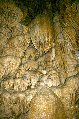
Luray Caverns, previously Luray Cave, is a cave just west of Luray, Virginia, United States, which has drawn many visitors since its discovery in 1878. The cavern system is adorned with speleothems such as columns, mud flows, stalactites, stalagmites, flowstone, and mirrored pools. The caverns host the Great Stalacpipe Organ, a lithophone made from solenoid-fired strikers that tap stalactites of varied sizes to produce tones similar to those of xylophones, tuning forks, or bells.

<span class="mw-page-title-main">Jewel Cave National Monument</span> Cave in the Black Hills of South Dakota, USA

Jewel Cave National Monument contains Jewel Cave, currently the fifth longest cave in the world and second longest cave in the United States, with 219.77 miles (353.69 km) of mapped passageways as of March 2024. It is located approximately 13 miles (21 km) west of the town of Custer in Black Hills of South Dakota. It became a national monument in 1908.

<span class="mw-page-title-main">Lechuguilla Cave</span> Cave in Eddy County, New Mexico, U.S.

At 150.4 miles (242.0 km), Lechuguilla Cave is the eighth-longest explored cave in the world and the second deepest in the continental United States. It is most famous for its unusual geology, rare formations, and pristine condition.

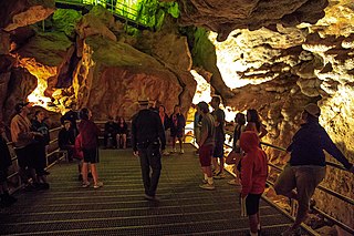
Timpanogos Cave National Monument is a United States National Monument protecting the Timpanogos Cave Historic District and a cave system on Mount Timpanogos in American Fork Canyon in the Wasatch Range, near Highland, Utah, in the United States. The site is managed by the National Park Service. The 1.5-mile (2.4 km) long trail to the cave entrance gains 1,092 feet (333 m) height, but it is paved and fairly wide making it accessible for most people. The three caves of the system, one of which is specifically called Timpanogos Cave, are only viewable on guided tours when the monument is open, usually from May through September depending on snow conditions and funding. There is the standard tour going through the cave system, and an Introduction to Caving tour which teaches Leave No Trace caving and goes further into Hansen Cave.

Cosmic Cavern is a limestone cave located in north Arkansas, near the town of Berryville, Arkansas.

<span class="mw-page-title-main">Delaware Basin</span> Geologic depositional and structural basin in West Texas and southern New Mexico

The Delaware Basin is a geologic depositional and structural basin in West Texas and southern New Mexico, famous for holding large oil fields and for a fossilized reef exposed at the surface. Guadalupe Mountains National Park and Carlsbad Caverns National Park protect part of the basin. It is part of the larger Permian Basin, itself contained within the Mid-Continent oil province.

<span class="mw-page-title-main">Cave of the Winds (Colorado)</span>

Cave of the Winds is a cave in the Pikes Peak region of Colorado. It is located just west of Colorado Springs on U.S. Highway 24, near the Manitou Cliff Dwellings. Tours of the complex of caves are given daily.

<span class="mw-page-title-main">Black Chasm Cave</span> Cave in California, U.S.

Black Chasm Cavern is a cave in the hamlet of Volcano in Amador County, California.

<span class="mw-page-title-main">Wyandotte Caves</span> Two caves in southern Indiana

The Wyandotte Caves is a pair of limestone caves located on the Ohio River in Harrison-Crawford State Forest in Crawford County, Indiana, 5 miles (8 km) north-east of Leavenworth and 12 miles (19 km) from Corydon in southern Indiana which are a popular tourist attraction. Wyandotte Caves were designated a National Natural Landmark in 1972. They are now part of O'Bannon Woods State Park. The cave system is the 5th largest in the state of Indiana.

<span class="mw-page-title-main">Grand Caverns</span>

Grand Caverns, formerly known as Weyer's Cave, is located in the central Shenandoah Valley in the town of Grottoes, Virginia, United States. A limestone cavern, it claims the distinction of being America's oldest show cave, in operation since 1806.

<span class="mw-page-title-main">James Larkin White</span> Discoverer of Carlsbad Caverns

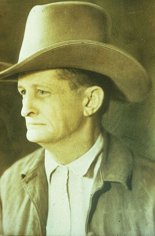
James Larkin White was a cowboy, guano miner, cave explorer, and park ranger for the National Park Service. He is best remembered as the discoverer, early promoter and explorer of what is known today as Carlsbad Caverns in Carlsbad Caverns National Park, New Mexico.

<span class="mw-page-title-main">Deer Cave</span>

Deer Cave, located near Miri, Sarawak, Malaysia, is a show cave attraction of Gunung Mulu National Park. It was surveyed in 1961 by G. E. Wilford of the British Borneo Geological Survey, who predicted that Mulu would yield many more caves in the future. The cave, which is also known as Gua Payau or Gua Rusa by the local Penan and Berawan people, is said to have received its name because of the deer that go there to lick salt-bearing rocks and shelter themselves.

<span class="mw-page-title-main">Blue Hole (New Mexico)</span> Sinkhole used for scubadiving in New Mexico, United States

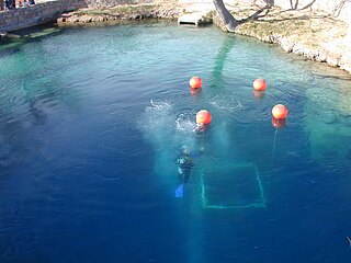
The Blue Hole of Santa Rosa, or simply the Blue Hole, is a circular, bell-shaped pool or small lake located along Route 66 east of Santa Rosa, New Mexico that is a tourist attraction and swimming venue, and one of the most popular dive destinations in the US for scuba diving and training. The Blue Hole is an artesian well and cenote that was once used as a fish hatchery.

<span class="mw-page-title-main">Gosu Cave</span> Limestone cave in Danyang, South Korea

Gosu Cave (Korean: 고수동굴), alternatively Kosu Cave, is a huge limestone cave near Danyang, South Korea formed over 450 million years ago. It is among the best known natural caves in Korea, and is known as the "underground palace". Gosu Cave is listed as the country's "Natural Monument No. 256".

<span class="mw-page-title-main">The Caverns Historic District</span> Historic district in New Mexico, United States

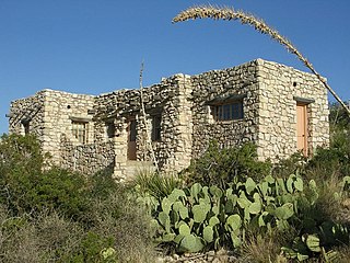
The Caverns Historic District comprises the central developed area of Carlsbad Caverns National Park. The complex was built between the early 1920s and 1942, initially in Pueblo Revival style, and later in New Mexico Territorial Revival style in the area around the natural entrance to Carlsbad Caverns. The earlier structures are built of local limestone, the later buildings in adobe. Thirteen buildings in the district are considered contributing structures. Buildings built between 1940 and 1942 were constructed with labor provided by the Civilian Conservation Corps.

<span class="mw-page-title-main">Kitley Show Cave</span> Cave in Devon, England

Kitley Show Cave is a solution cave in Yealmpton, Devon, England. Originally discovered by quarrying, it used to be open to the public as a show cave, but is now closed.

References

  1. "Listing of acreage – December 31, 2011" (XLSX). Land Resource Division, National Park Service. Retrieved March 6, 2012. (National Park Service Acreage Reports)
  2. "Annual Visitation Report by Years: 2009 to 2019". nps.gov. National Park Service. Retrieved August 16, 2020.
  3. "History & Culture". National Park Service . Retrieved May 31, 2007.
  4. "The Largest Underground Chambers by Surface Area" . Retrieved June 25, 2020.
  5. "What to know about Carlsbad Caverns National Park". Deseret News. Retrieved July 17, 2023.
  6. 1 2 National Park Service, Cave Geology: Dissolution and decoration (PDF), retrieved July 13, 2012
  7. National Park Service. "Surface Geology: From living reef to desert mountains" (PDF). Retrieved July 13, 2012.
  8. "Carlsbad Caverns" (PDF). Cave Geology: Dissolution and decoration. National Park Service / U.S. Department of the Interior. Retrieved January 26, 2021.
  9. "Carlsbad Caverns" (PDF). Cave Geology: Dissolution and decoration. National Park Service / U.S. Department of the Interior. Retrieved January 26, 2021.
  10. "speleothems". Missouri State Parks. Missouri Department of Natural Resources. February 9, 2011. Retrieved January 26, 2021.
  11. "U.S. Climate Normals Quick Access – Station: Carlsbad Caverns, NM". National Oceanic and Atmospheric Administration. Retrieved May 1, 2023.
  12. "NOAA Online Weather Data – NWS Midland". National Weather Service. Retrieved May 1, 2023.
  13. "Elevators Whisk Tourist to Bottom of 750-Foot Cave" Popular Science, May 1932, drawings of visitor center and elevators
  14. 1 2 "Creation of Carlsbad Cave National Monument". National Park Service . Retrieved July 13, 2012.
  15. "Carlsbad Cave National Monument – Executive Order". National Park Service . Retrieved July 13, 2012.
  16. "Carlsbad Cave National Monument – Supplemental Executive Order". National Park Service . Retrieved July 13, 2012.
  17. "Creation of Carlsbad Cavern National Park". National Park Service . Retrieved July 13, 2012.
  18. "Carlsbad Caverns National Park – Executive Order". National Park Service . Retrieved July 13, 2012.
  19. "Jimmy Carter – National Parks and Recreation Act of 1978 Statement on Signing S. 791 Into Law". University of California, Santa Barbara . Retrieved July 13, 2012.
  20. "Big Room Self-Guided Route". National Park Service. August 15, 2005. Retrieved July 13, 2012.
  21. "The heart of Carlsbad Cavern". Rocky Mountain Caving. Retrieved February 9, 2023.
  22. "NPS Annual Recreation Visits Report". National Park Service. Retrieved March 6, 2019.
  23. National Park Service. "Fees and Reservations" . Retrieved July 14, 2012.
  24. National Park Service. "Bat Flight Program" . Retrieved July 14, 2012.
  25. National Park Service. "Night Sky Events" . Retrieved July 14, 2012.
  26. "Cave History Update #8, December 15, 2003: 18th Anniversary of Spirit World Exploration at Caverns" (PDF). National Park Service. Retrieved July 13, 2012.
  27. Jonathan Smith (November 15, 2013). "'Halloween Hall' at Carlsbad Caverns is biggest area discovered in more than 25 years". Current-Argus News. Archived from the original on November 18, 2013.
  28. "Cave Exploration Milestones" (PDF). Carlsbad Caverns National Park. Archived (PDF) from the original on October 4, 2021. Retrieved October 4, 2021.
  29. Bristol, Derek (December 22, 2019). "Carlsbad Cavern - 8-Day Expedition". YouTube . Archived from the original on December 14, 2021. Retrieved October 4, 2021.
  30. "Carlsbad Caverns National Park". National Park Service. Retrieved December 28, 2011.
  31. "Carlsbad Caverns National Park; Slaughter Canyon Cave Tour". National Park Service. Retrieved December 28, 2011.
  32. "Carlsbad Caverns National Park; Spider Cave Tour". National Park Service. Retrieved December 28, 2011.
  33. 1 2 3 4 "Carlsbad Caverns National Park: Lechuguilla Cave". NPS . Retrieved December 28, 2011.
  34. "Deepest cave discovered in the Bob". Missoula Independent. Retrieved October 23, 2015.
  35. 1 2 "Carlsbad Caverns National Park: Bats". National Park Service. Retrieved January 26, 2009.
  36. "Why Are We Losing Our Mexican Free-tailed Bats?". Bat Conservation International. Archived from the original on February 26, 2021. Retrieved January 26, 2021.
  37. Susan Millius. "Carlsbad's 8 million 'lost' bats likely never existed" (PDF). Science News. Retrieved January 26, 2009.
  38. "Carlsbad Caverns National Park: Bat Research: How many bats and other common questions" (PDF). National Park Service. Retrieved January 26, 2009.
  39. 1 2 "Carlsbad Caverns National Park - Bat Flight Program". National Park Service. Retrieved October 3, 2009.
  40. "Carlsbad Caverns National Park – Brazilian Free-Tail Bat Outflight". National Park Service. Retrieved October 3, 2009.
  41. Jim White. "Carlsbad, New Mexico". PBS Weekend Explorer. Retrieved October 3, 2009.
  42. Swanson, Betsy (August 1986). "National Register of Historic Places Inventory - Nomination Form: The Caverns Historic District". National Park Service. Retrieved June 23, 2011.
  43. 1 2 "Carlsbad Caverns National Park - Animals". National Park Service. Retrieved October 3, 2009.
  44. Parmeter, John; Neville, Bruce; Emkalns, Doug (2002). New Mexico Bird Finding Guide (Third ed.). New Mexico Ornithological Society. pp. 2, 251.
  45. Swanson, Betsy (October 1986). "National Register of Historic Place Inventory - Nomination Form: Rattlesnake Springs Historic District". National Park Service. Retrieved August 28, 2011.
  46. Pawlowski, Andrew C.; Wang, Wenliang; Koteva, Kalinka; Barton, Hazel A.; McArthur, Andrew G.; Wright, Gerard D. (December 2016). "A diverse intrinsic antibiotic resistome from a cave bacterium". Nature Communications. 7 (1): 13803. Bibcode:2016NatCo...713803P. doi:10.1038/ncomms13803. PMC   5155152 . PMID   27929110.
  47. "Antibiotic resistant bacteria discovered in isolated New Mexico cave". New Atlas. April 18, 2012. Retrieved October 5, 2021.