Related Research Articles

Crawford County is a county located in the north central portion of the U.S. state of Ohio. As of the 2020 census, the population was 42,025. Its county seat and largest city is Bucyrus. The county was created in 1820 and later organized in 1836. It was named for Colonel William Crawford, a soldier during the American Revolution.
Leesville is a village in southwestern Carroll County, Ohio, United States. The population was 127 at the 2020 census. It is part of the Canton–Massillon metropolitan area.

Crestline is a village in Crawford and Richland Counties in the U.S. state of Ohio. Crestline's population was 4,525 at the 2020 census. It is the third largest municipality in Crawford County. The Crawford County portion of Crestline is part of the Bucyrus Micropolitan Statistical Area, while the small portion of the village that extends into Richland County is considered part of the Mansfield Metropolitan Statistical Area.

The Sandusky River is a tributary to Lake Erie in north-central Ohio in the United States. It is about 133 miles (214 km) long and flows into Lake Erie at the southwest side of Sandusky Bay.

The Doña Ana Mountains are a mountain range in Doña Ana County, New Mexico. The highest elevation in the range is Doña Ana Peak at 5,835 feet, at 32°27′15″N106°47′18″W.

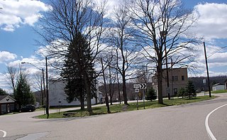
Sulphur Springs is a census-designated place (CDP) in eastern Liberty Township, Crawford County, Ohio, United States. As of the 2020 census it had a population of 197. It has a post office with the ZIP code 44881. It is located along State Route 98 northeast of the city of Bucyrus, the county seat of Crawford County.

North Central State College is a public community college in Mansfield, Ohio. It is located on the 644-acre (261 ha) campus of The Ohio State University at Mansfield. NCSC offers associate degrees and certification programs in a number of career fields, including business, computers, engineering, health science and public service, technology, and workforce development.

The Mansfield Metropolitan Statistical Area, as defined by the United States Census Bureau, is an area consisting of one county – Richland – in north central Ohio, anchored by the city of Mansfield. As of the 2010 census, the MSA had a population of 124,475.
Conotton Creek is a tributary of the Tuscarawas River, 38.7 miles (62.3 km) long, in eastern Ohio in the United States. Via the Tuscarawas, Muskingum and Ohio Rivers, it is part of the watershed of the Mississippi River, draining an area of 286 square miles (741 km²) in Carroll, Harrison and Tuscarawas County, Ohio. The source is at 1240 feet and the mouth is at 874 feet. Dover Dam, downstream on the Tuscarawas river, is normally dry, but can impound a reservoir on Conotton and tributaries to a pool elevation of 916 feet for downstream flood control by the Corps of Engineers. From its source in eastern Harrison County, Ohio the creek flows west northwest through Jewitt, Scio, Conotton, Bowerston, Leesville, Sherrodsville, New Cumberland and Somerdale before reaching its mouth in central Tuscarawas County, Ohio. The Wheeling and Lake Erie Railway is situated in the valley. Ohio State Route 151 runs in the valley from near the source to Bowerston. Ohio State Route 212 run along the valley from Bowerston to the mouth. The Conotton Creek Trail runs from Bowerston to Jewett.

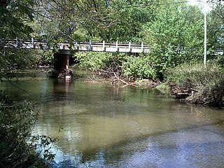
Leesville Lake is a reservoir located near Ohio State Route 212 and Leesville, Ohio. The lake is formed by Leesville Dam 40°28′6″N81°11′41″W across McGuire Creek, a tributary of Conotton Creek. The lake is named for the village of Leesville.
Flint Hill, Pittsylvania County is an unincorporated community in Pittsylvania County, in the U.S. state of Virginia.

Waynesburg is an unincorporated community in Auburn Township, Crawford County, Ohio, United States.
Mechanicsburg is an unincorporated community in Auburn Township, Crawford County, Ohio, United States.
Olentangy is an unincorporated community in Whetstone Township, Crawford County, Ohio, United States.

New Winchester is an unincorporated community in Whetstone Township, Crawford County, Ohio, United States.
West Liberty is an unincorporated community in Vernon Township, Crawford County, Ohio, United States.
DeKalb is an unincorporated community in Vernon Township, Crawford County, Ohio, United States.
Middletown is an unincorporated community in Jefferson Township, Crawford County, Ohio, United States.
Crawford Corners is an unincorporated community in Medina County, in the U.S. state of Ohio.
References
- ↑ U.S. Geological Survey Geographic Names Information System: Leesville
- ↑ History of Crawford County and Ohio. Baskin & Battey. 1881. pp. 646.
Municipalities and communities of Crawford County, Ohio, United States | ||
|---|---|---|
| Cities |  | |
| Villages | ||
| Townships | ||
| CDPs | ||
| Unincorporated communities | ||
| Footnotes | ‡This populated place also has portions in an adjacent county or counties | |
40°47′43″N82°47′18″W / 40.79528°N 82.78833°W
| | This Crawford County, Ohio state location article is a stub. You can help Wikipedia by expanding it. |