Crawford County is a county located in the north central portion of the U.S. state of Ohio. As of the 2020 census, the population was 42,025. Its county seat and largest city is Bucyrus. The county was created in 1820 and later organized in 1836. It was named for Colonel William Crawford, a soldier during the American Revolution.

Butler County is a county located in the southwestern part of the U.S. state of Ohio. As of the 2020 census, the population was 390,357. Its county seat and largest city is Hamilton. It is named for General Richard Butler, who died in 1791 during St. Clair's Defeat. Located along the Great Miami River, it is also home to Miami University, a public university founded in 1809. Butler County is part of the Cincinnati, OH-KY-IN Metropolitan Statistical Area. The majority of the county is in District 52 of the State House.
Ross is a census-designated place (CDP) in Ross Township, Butler County, Ohio, United States. The population was 3,478 at the 2020 census. Ross sits along U.S. Route 27 between Cincinnati, Ohio and Oxford, Ohio. Ross is part of the Cincinnati metropolitan area.

Bucyrus is a city in the U.S. state of Ohio and the county seat of Crawford County, located in northern Ohio approximately 28 miles (45 km) west of Mansfield and 66 miles (106 km) southeast of Toledo. The population was 11,684 at the time of the 2020 census. The city is the largest in Crawford County, and the center of the Bucyrus Micropolitan Statistical Area.

Brady Lake is an unincorporated census-designated place and former village in Portage County, Ohio, United States. The population was 1,222 at the 2020 census. Incorporated in 1927, it originally developed as an amusement park and summer resort that opened in 1891. It was formed from a small portion of Franklin Township and became fully independent of the township in 1993. The village was named after the lake it borders, Brady Lake, which in turn was named for Captain Samuel Brady, who hid in the lake around 1780 while being pursued by a band of local Native Americans.
Monroe is a city in east central Butler and west central Warren counties in the southwestern part of the U.S. state of Ohio. The population was 15,412 at the 2020 census. Monroe is a part of the Cincinnati metropolitan area.

Monnett Bain Davis was an American diplomat in the early and mid 20th century.

Orra Eugene Monnette (1873–1936) was an attorney, author and banker. Monnette was also the founder of the Bank of America, L.A.
Kirkpatrick is an unincorporated community in northern Scott Township, Marion County, Ohio, United States. The ZIP code assigned to Kirkpatrick by the United States Postal Service is 43302 — the same as Marion. Kirkpatrick is the location of the Scott Township Hall. The current population of Kirkpatrick is less than 200. Kirkpatrick is served by Ridgedale Local School District. Kirkpatrick is the location of the Scott Township Hall.

Dover Township is one of the twelve townships of Fulton County, Ohio, United States. The 2020 census found 1,621 people in the township.
Franklin Township is one of the twelve townships of Fulton County, Ohio, United States. The 2020 census found 695 people in the township. The Township Hall is located at the hamlet of Zone.

Painesville Township is one of the five townships of Lake County, Ohio, United States. The population was 20,453 at the 2020 census. It is a part of Greater Cleveland in the Northeast Ohio Region, and is included in the Cleveland-Akron-Canton, Ohio combined statistical area in the United States.

Sulphur Springs is a census-designated place (CDP) in eastern Liberty Township, Crawford County, Ohio, United States. As of the 2020 census it had a population of 197. It has a post office with the ZIP code 44881. It is located along State Route 98 northeast of the city of Bucyrus, the county seat of Crawford County.

Oceola is a census-designated place (CDP) in central Tod Township, Crawford County, Ohio, United States. As of the 2020 census its population was 156. It has a post office with the ZIP code 44860. It is located along the road that was U.S. Route 30 until being upgraded to a freeway.

Maynard is an unincorporated community located in western Colerain Township, Belmont County, Ohio, United States, along Wheeling Creek. It has a post office with the ZIP code 43937.

Brokensword is an unincorporated community on the border between the Holmes and Lykens townships of Crawford County, Ohio, United States. Located at the intersection of the concurrent State Routes 19 and 100 with Brokensword Road, it is six miles north and two miles west of the city of Bucyrus, the county seat. Broken Sword Creek flows a short distance to the south of the community.
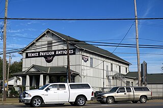
Carrothers is an unincorporated community in Venice Township, Seneca County, Ohio, United States. It is located along State Route 4, just north of the border between Seneca and Crawford County. The community is served by the Attica (44807) post office.
The Ohio Department of Youth Services (DYS) is the administrative department of the Ohio state government responsible for juvenile corrections. It has its headquarters in Columbus.

Claridon is an unincorporated community in Marion County, Ohio, United States. Claridon is located on Ohio State Route 95, 7 miles (11 km) east of Marion, between Marion and Mt. Gilead. The community is served by River Valley Local School District.