
Yankton County is a county in the U.S. state of South Dakota. As of the 2020 United States Census, the population was 23,310. Its county seat is Yankton. Yankton County comprises the Yankton, SD Micropolitan Statistical Area.

Yankton is a city in and the county seat of Yankton County, South Dakota, United States.

Lake Sharpe is a large reservoir impounded by Big Bend Dam on the Missouri River in central South Dakota, United States. The lake has an area of 56,884 acres (230.20 km2) and a maximum depth of 78 ft (24 m). Lake Sharpe is approximately 80 mi (130 km) long, with a shoreline of 200 mi (320 km). Lake Sharpe is the 54th largest reservoir in the United States. The lake starts near Ft. Thompson and stretches upstream to Oahe Dam, near Pierre. The lake is located within the following counties: Buffalo, Lyman, Hyde, Hughes, and Stanley. The Big Bend of the Missouri is about 7 miles (11 km) north of the dam.

Lake Oahe is a large reservoir behind Oahe Dam on the Missouri River; it begins in central South Dakota and continues north into North Dakota in the United States. The lake has an area of 370,000 acres (1,500 km2) and a maximum depth of 205 ft (62 m). By volume, it is the fourth-largest reservoir in the US. Lake Oahe has a length of approximately 231 mi (372 km) and has a shoreline of 2,250 mi (3,620 km). 51 recreation areas are located along Lake Oahe, and 1.5 million people visit the reservoir every year. The lake is named for the 1874 Oahe Indian Mission.
Pactola Lake is the largest and deepest reservoir in the Black Hills, located 15 miles west of Rapid City, South Dakota, United States. Constructed in 1952, the dam and waters are managed by the Bureau of Reclamation, with the surrounding land managed by the US Forest Service as part of Black Hills National Forest, which operates a visitor center located on the south side of the dam. Facilities include campgrounds, hiking trails, picnic areas, and a beach.

Foster Reservoir is a reservoir created by Foster Dam on the South Santiam River in the city of Foster, Oregon, United States. The reservoir is approximately 5.6 km (3.5 mi) long and covers approximately 494 ha when full. Primary use of the reservoir is recreation in the summer and flood control in the winter and spring.

Gavins Point Dam is a 1.9 mi (3 km) long embankment rolled-earth and chalk-fill dam which spans the Missouri River and impounds Lewis and Clark Lake. The dam joins Cedar County, Nebraska with Yankton County, South Dakota a distance of 811.1 river miles (1,305 km) upstream of St. Louis, Missouri, where the river joins the Mississippi River. The dam and hydroelectric power plant were constructed as the Gavins Point Project from 1952 to 1957 by the United States Army Corps of Engineers as part of the Pick-Sloan Plan. The dam is located approximately 4 miles (6.4 km) west or upstream of Yankton, South Dakota.

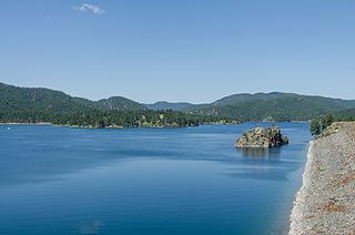
Lewis and Clark Lake is a 31,400 acre (130 km²) reservoir located on the border of the U.S. states of Nebraska and South Dakota on the Missouri River. The lake is approximately 25 miles (40 km) in length with over 90 miles (140 km) of shoreline and a maximum water depth of 45 feet (14 m). The lake is impounded by Gavins Point Dam and is managed by the U.S. Army Corps of Engineers, Omaha District.
The Missouri National Recreational River is a National Recreational River located on the border between Nebraska and South Dakota. The designation was first applied in 1978 to a 59-mile section of the Missouri River between Gavins Point Dam and Ponca State Park. In 1991, an additional 39-mile section between Fort Randall Dam and Niobrara, Nebraska, was added to the designation. These two stretches of the Missouri River are the only parts of the river between Montana and the mouth of the Missouri that remain undammed or unchannelized. The last 20 miles of the Niobrara River and 6 miles of Verdigre Creek were also added in 1991.
Marindahl Lake is a small lake located north of the city of Volin, South Dakota.

Lake Francis Case is a large reservoir impounded by Fort Randall Dam on the Missouri River in south-central South Dakota, United States. The lake has an area of 102,000 acres (410 km2) and a maximum depth of 140 ft (43 m). Lake Francis Case has a length of approximately 107 mi (172 km) and has a shoreline of 540 mi (870 km). The lake is the eleventh-largest reservoir in the United States and is located within the counties of: Charles Mix, Gregory, Lyman, Brule, and Buffalo. The lake stretches from Pickstown, South Dakota upstream to Big Bend Dam.

Calumet Bluff is a hill about 180 feet high overlooking Lewis and Clark Lake and the Missouri River in Cedar County, Nebraska, U.S., where the Lewis and Clark Expedition held its first council with the Sioux Indians for two days in 1804. Today the Bluff forms the right or south abutment of the Gavins Point Dam. The U.S. Army Corps of Engineers maintains the Lewis and Clark Visitor Center and the Gavins Point Project Administration Offices on Calumet Bluff overlooking the dam.

Lake Yankton, also called Cottonwood Lake, is an artificial lake that was originally part of the main channel of the Missouri River on the border of the U.S. States of Nebraska and South Dakota, near Yankton, South Dakota. The lake has an approximate surface area of 250 acres (100 ha) and has a maximum depth of 18 feet (5.5 m). The lake is located immediately downstream (east) of Gavins Point Dam and Lewis and Clark Lake, located just north of the current location of the main channel of the Missouri River.

Lewis and Clark State Recreation Area (SRA) is an 864-acre State Recreation Area located on the southern shore of Lewis and Clark Lake, in northeastern Nebraska. The recreation area is located in Knox County, approximately 12 miles (19 km) northwest of Crofton. The recreation area is managed by the Nebraska Game and Parks Commission.
Chief White Crane Recreation Area is a state recreation area in southeastern South Dakota, United States. It is located about 5 miles (8.0 km) west of Yankton and located on the shores of the Missouri River and Lake Yankton. The recreation area is located about 1.5 miles (2.4 km) downstream of Gavins Point Dam and Lewis and Clark Lake.
Pierson Ranch Recreation Area is a state recreation area in Yankton County, South Dakota in the United States. The recreation area is 60 acres (24 ha) and lies directly below Gavins Point Dam and Lewis and Clark Lake and is adjacent to Lake Yankton. The area is open for year-round recreation including camping, swimming, fishing, hiking and boating. It is 4 miles (6.4 km) west of Yankton.
Training Dike Recreation Area, also called Training Dike Day-Use Area is a U.S. Army Corps of Engineers public recreation area located immediately downstream of Gavins Point Dam and Lewis and Clark Lake on the north bank of the Missouri River. The area is about 4.5 miles (7.2 km) west of Yankton. The area is located mostly in Cedar County, Nebraska, with a small portion located in Yankton County, South Dakota.
Cottonwood Recreation Area is a public recreation area located in Cedar County, Nebraska, U.S. It is located about 5 miles (8.0 km) west of Yankton and located on the shores of Lake Yankton. The recreation area is located immediately downstream of Gavins Point Dam and Lewis and Clark Lake. It is named for Cottonwood Island, an original island located in the Missouri River, for the large groves of Cottonwood Trees that dominate the area. The recreation area is owned and managed by the U.S. Army Corps of Engineers.
Springfield Recreation Area is a state recreation area in Bon Homme County, South Dakota in the United States. The recreation area is located on the upper part of Lewis and Clark Lake, and is popular for boating, fishing, and hunting. There is a 20-site campground and a boat launch to access the lake and the Missouri River. The area is about 30 miles west of Yankton.

Snake Creek Recreation Area is a South Dakota state recreation area in Charles Mix County, South Dakota in the United States. The recreation area is 695 acres (281 ha) and lies along the shores of Lake Francis Case, a reservoir on the Missouri River. The area is open for year-round recreation including camping, swimming, fishing, hiking and boating. There are 115 campsites, 10 camper cabins, and a full-service marina. The recreation area is 14 miles (23 km) west of Platte.


