The Nakhchivan Autonomous Republic is a landlocked exclave of the Republic of Azerbaijan. The region covers 5,502.75 km2 (2,124.62 sq mi) with a population of 459,600. It is bordered by Armenia to the east and north, Iran to the southwest, and Turkey to the west. It is the sole autonomous republic of Azerbaijan, governed by its own elected legislature.

Sadarak District is one of the 7 districts of the Nakhchivan Autonomous Republic of Azerbaijan. The district borders the district of Sharur, as well as the Iğdır Province of Turkey, Ararat Province of Armenia and the West Azerbaijan Province of Iran. Its capital is Heydarabad and largest settlement is Sadarak. As of 2020, the district had a population of 16,100.

Sharur District is one of the 7 districts of the Nakhchivan Autonomous Republic of Azerbaijan. The district borders the districts of Kangarli, Sadarak, as well as the Vayots Dzor and Ararat provinces of Armenia and the West Azerbaijan Province of Iran. Its capital and largest city is Sharur. As of 2020, the district had a population of 117,600.

Babek District is one of the 7 districts of the Nakhchivan Autonomous Republic of Azerbaijan. The district borders the districts of Julfa, Shahbuz, Kangarli, Nakhchivan city, as well as the Vayots Dzor Province of Armenia and the East Azerbaijan and West Azerbaijan provinces of Iran. Its capital and largest city is Babek. As of 2020, the district had a population of 76,200.
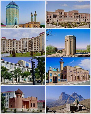
Nakhchivan is the capital and largest city of the eponymous Nakhchivan Autonomous Republic, a true exclave of Azerbaijan, located 450 km (280 mi) west of Baku. The municipality of Nakhchivan consists of the city of Nakhchivan, the settlement of Əliabad and the villages of Başbaşı, Bulqan, Haciniyyət, Qaraçuq, Qaraxanbəyli, Tumbul, Qarağalıq, and Daşduz. It is spread over the foothills of Zangezur Mountains, on the right bank of the Nakhchivan River at an altitude of 873 m (2,864 ft) above sea level.

Shahbuz District is one of the 7 districts of the Nakhchivan Autonomous Republic of Azerbaijan. The district borders the districts of Julfa, Babek, and the Syunik and Vayots Dzor provinces of Armenia. Its capital and largest city is Shahbuz. As of 2020, the district had a population of 25,300.
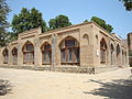
Julfa, formerly Jugha, is a city and the capital of the Julfa District of the Nakhchivan Autonomous Republic of Azerbaijan.

Kangarli District is one of the 7 districts of the Nakhchivan Autonomous Republic of Azerbaijan. The district borders the districts of Babek, Sharur, Nakhchivan city, as well as the Vayots Dzor Province of Armenia and the West Azerbaijan Province of Iran. Its capital is Givrag, while the largest settlement is Khok. As of 2020, the district had a population of 32,700.
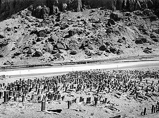
The Armenian cemetery in Julfa was a cemetery near the town of Julfa, in the Nakhchivan exclave of Azerbaijan that originally housed around 10,000 funerary monuments. The tombstones consisted mainly of thousands of khachkars—uniquely decorated cross-stones characteristic of medieval Christian Armenian art. The cemetery was still standing in the late 1990s, when the government of Azerbaijan began a systemic campaign to destroy the monuments.
Vənənd is a village and municipality in the Ordubad District of Nakhchivan, Azerbaijan. It is located in the near of the Ordubad-Unus highway, 17 km in the north-west from the district center, on the bank of the Vanandchay river. People of the village is busy with gardening, grain growing, cotton-growing, animal husbandry. There are secondary school, music school, library, culture house, a medical center and kindergarten in the village. It has a population of 2,347. The municipality consists of the villages of Vənənd and Xanağa.
Ələhi is a village and municipality in the Ordubad District of Nakhchivan, Azerbaijan, in the administrative unit of Bist village. It is located in the west of the Ordubad-Xurs highway, on the right bank of the Ayrichay river, on the foothill of the Gapyjyg mountain. Its population is busy with gardening, beekeeping, animal husbandry. There are incomplete secondary school, club, library, and a medical center in the village. It has a population of 132.
Archeological sites in Azerbaijan first gained public interest in the mid-19th century and were reported by European travellers.

Western Azerbaijan is an irredentist political concept that is used in the Republic of Azerbaijan mostly to refer to the territory of the Republic of Armenia. Azerbaijani officials claim that the territory of the modern Armenian republic were lands that once belonged to Azerbaijanis. Its claims are primarily hinged over the contention that the current Armenian territory was under the rule of various Turkic tribes, empires and khanates from the Late Middle Ages until the Treaty of Turkmenchay (1828) signed after the Russo-Persian War of 1826–1828. The concept has received official endorsement by the government of Azerbaijan, and has been used by its current president, Ilham Aliyev, who, since around 2010, has made regular reference to "Irevan" (Yerevan), "Göyçə" and "Zangazur" (Syunik) as once and future "Azerbaijani lands". The irredentist concept of "Western Azerbaijan" is associated with other irredentist claims promoted by Azerbaijani officials and academics, including the "Goycha-Zangazur Republic" and the "Republic of Irevan."

Gamigaya rock carvings - are dated to the 4th-1st millennia BC including the Bronze and Early Iron Ages in the territory of Ordubad Rayon, not far from Nəsirvaz village's border and Azerbaijan’s border with Armenia.
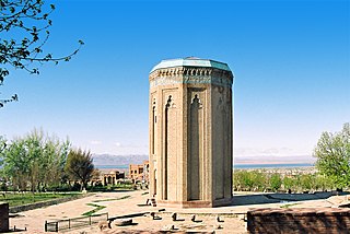
The architectural school of Nakhchivan is one of architectural schools developed in medieval ages on the territory of modern Azerbaijan. It was founded by Ajami Nakhchivani in the 12th century. The mausoleums of Yusif ibn Kuseyir and Momine Khatun, constructed by him in Nakhchivan are a classical example of constructions of this school.
The Poldasht-Shah Takhti Bridge is a bridge located between Poldasht in the West Azerbaijan Province of Iran, and Shah Takhti in the Nakhchivan Autonomous Republic of Azerbaijan. The structure spans the Aras River, and serves as a border crossing that allows access to Nakhchivan without having to pass through Armenia. Construction was finished in 2007. The bridge has a length of 538 feet, and was built at a cost of Rls.40 billion.
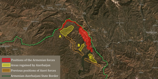
The 2018 Armenian–Azerbaijani clashes began on 20 May 2018 between the Armenian Armed Forces and Azerbaijani Armed Forces. Azerbaijan stated to have taken several villages and strategic positions within the Nakhchivan Autonomous Republic. However, these areas had previously been part of a no man's land between the Azerbajiani and Armenian lines.
The Nakhchivan Autonomous Republic is one of the touristic regions of Azerbaijan with its flora and fauna, climate, and ancient cultural monuments. Nakhchivan is known for its historical monuments such as Momuna Khatun, Yusif ibn Kuseyir, Gulustan tombs, and Garabaghlar. There are other touristic places like Babek castle, Kilit cave, Alinja castle, and Gamigaya in Nakhchivan.
Mountains of Azerbaijan cover approximately 60 percent of the country's land area. There are three mountain ranges in the territory of Azerbaijan, which are the Greater Caucasus, the Lesser Caucasus, and the Talysh Mountains.

The Nakhchivan culture, also known as the Kizilveng culture or Painted Pottery culture, was formed during the Middle Bronze Age in the 3rd and 2nd millennium BC. The main center of painted pottery were Nakhchivan and the Arpachay Valley, in Anatolia, Urmia lake basin and the South Caucasus. In Azerbaijan, this culture was studied on the basis of archeological materials from the I Kultepe, II Kultepe, Shahtakhti, Gizilburun, Nahjir, Shortepe, Garachuk, II Gazanchi qala and other monuments. The painted pottery culture was studied by Azerbaijani archaeologists such as O. Habibullayev, V. Bakhshaliyev, V. Aliyev and A. Akbarov. According to V. Bakhshaliyev, the formation of this culture dishes in Nakhchivan was connected with the formation of the city states.